Select location of well to view details.
Click on column heading to sort.
|
|
|
County: Norton Select location of well to view details. Click on column heading to sort. |
|
|
|
| View page: < Prev || 21 || 22 || 23 || 24 || 25 || 26 || 27 || 28 || 29 || 30 || Next > | |||||||||
| T-R-S | Owner | Well Depth Ascend. Desc. |
Static Water Level Ascend. Desc. |
Est. Yield Ascend. Desc. |
Well Use | Other ID | Action Taken | Completion Date Ascend. Desc. |
Scan? |
|
T3S, R22W, Sec. 31 SW SE SE |
Evans, Scott | 273 ft. | 125 ft. | Irrigation | Constructed | 26-Mar-1997 | |||
|
T3S, R22W, Sec. 31 NW NW SW |
Persinger Farms LLC | 256 ft. | 123 ft. | 25 gpm. | Domestic | Constructed | 25-Mar-2009 | ||
|
T3S, R22W, Sec. 32 SW NW NW SW |
Evans, Scott | 283 ft. | 110 ft. | 600 gpm. | Irrigation | Reconstructed | 28-Aug-2017 |
KOLAR |
|
|
T3S, R22W, Sec. 32 SW NW NW SW |
Evans, Scott | 283 ft. | 102 ft. | 800 gpm. | Irrigation | Constructed | 02-Apr-2015 |
KOLAR |
|
|
T3S, R22W, Sec. 32 SW NW NW SW |
Evans, Scott | 270 ft. | 145 ft. | 100 gpm. | Domestic, Livestock | Constructed | 01-Apr-2015 |
KOLAR |
|
|
T3S, R22W, Sec. 32 W2 SW |
Evans, Scott | 215 ft. | 139 ft. | Domestic | Constructed | 02-Mar-1996 | |||
|
T3S, R22W, Sec. 33 SW SW SW NE |
Doyle Schoen Trust | 175 ft. | 60 ft. | 50 gpm. | Domestic, Livestock | Constructed | 13-Aug-2014 |
KOLAR |
|
|
T3S, R22W, Sec. 34 NW NW NW NE |
Esslinger Ranch | 108 ft. | 35 ft. | 40 gpm. | Domestic, Livestock | Constructed | 08-Oct-2020 |
KOLAR |
|
|
T3S, R22W, Sec. 35 NE NE SE |
Esslinger Ranch | 105 ft. | Oil Field Water Supply | Constructed | 02-Nov-2010 | ||||
|
T3S, R22W, Sec. 35 SE NE NE |
Esslinger Ranch | 104 ft. | 55 ft. | Domestic | Constructed | 28-Feb-1990 | |||
|
T3S, R22W, Sec. 35 SE SW SW |
Sansom, Rod | 88 ft. | 40 ft. | 25 gpm. | Domestic, Livestock | Constructed | 09-Oct-2024 |
KOLAR |
|
|
T3S, R23W, Sec. 1 SW SW SW |
Allen, Ronald | 120 ft. | 106 ft. | Domestic | Constructed | 16-Aug-1985 | |||
|
T3S, R23W, Sec. 1 NE NW NE |
Allen, Ronald | 78 ft. | 37 ft. | 20 gpm. | Domestic | Constructed | 24-Sep-1976 | ||
|
T3S, R23W, Sec. 1 NW NE NE |
Cozad, David | 70 ft. | 41 ft. | 11 gpm. | Domestic | Constructed | 02-Feb-1977 | ||
|
T3S, R23W, Sec. 1 NE NW NE |
Enfield, Andy | 77 ft. | 33 ft. | 15 gpm. | Domestic | Constructed | 12-Sep-2023 |
KOLAR |
|
|
T3S, R23W, Sec. 1 NW NW NE |
Enfield, Larry | 75 ft. | 37 ft. | 30 gpm. | Domestic | Constructed | 24-Mar-1978 | ||
|
T3S, R23W, Sec. 1 NE NE NW |
Johnson, Donald | 75 ft. | 35 ft. | 35 gpm. | Domestic | Constructed | 17-Mar-1977 | ||
|
T3S, R23W, Sec. 1 NE NE SE |
McCormick, Bernard | 140 ft. | 120 ft. | 15 gpm. | Domestic | Constructed | 02-Oct-1980 | ||
|
T3S, R23W, Sec. 2 N2 SW |
Bohl, Mable | 60 ft. | 42 ft. | Domestic | Constructed | 24-Aug-1994 | |||
|
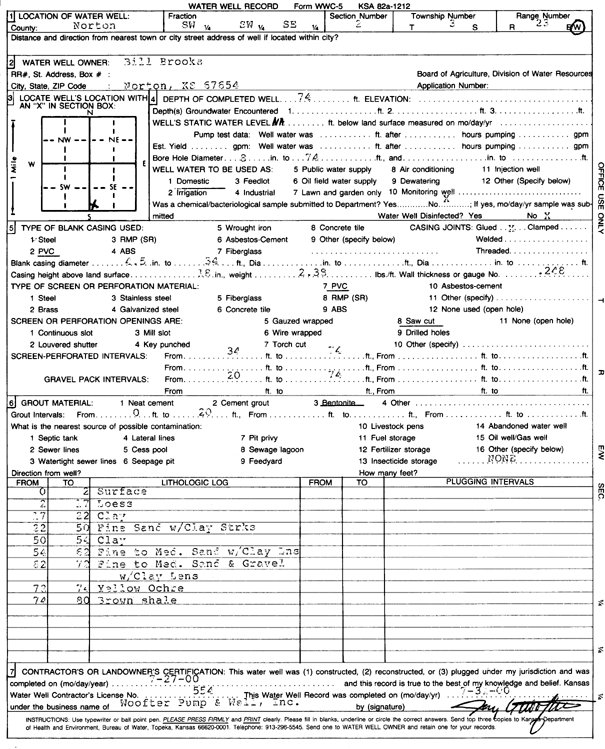
T3S, R23W, Sec. 2 SW SW SE |
Brooks, Bill | 74 ft. | Domestic | Constructed | 27-Jul-2000 | Scan | |||
|
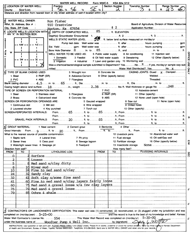
T3S, R23W, Sec. 2 SE SE SE |
Fisher, Ron | 85 ft. | 58 ft. | Domestic | Constructed | 25-May-2000 | Scan | ||
|
T3S, R23W, Sec. 2 NE NE SE |
Grysch, Anthony | 78 ft. | 45 ft. | 20 gpm. | Domestic | Constructed | 27-May-2005 | ||
|
T3S, R23W, Sec. 2 SE NW NW NW |
KDHE | 44 ft. | 29.86 ft. | Monitoring well/observation/piezometer | MW 6 | Constructed | 01-Feb-2018 |
KOLAR |
|
|
T3S, R23W, Sec. 2 SE SW NW NW |
KDHE | 26 ft. | 8.44 ft. | Monitoring well/observation/piezometer | MW 1 | Constructed | 01-Feb-2018 |
KOLAR |
|
|
T3S, R23W, Sec. 2 SW NW NW NW |
KDHE | 50 ft. | 32.63 ft. | Monitoring well/observation/piezometer | MW 4 | Constructed | 09-Feb-2018 |
KOLAR |
|
|
T3S, R23W, Sec. 2 SE SW NW NW |
KDHE | 25.2 ft. | 6.17 ft. | Monitoring well/observation/piezometer | MW 3 | Constructed | 01-Feb-2018 |
KOLAR |
|
|
T3S, R23W, Sec. 2 SW NW NW NW |
KDHE | 50.1 ft. | 38.55 ft. | Monitoring well/observation/piezometer | MW 5 | Constructed | 08-Feb-2018 |
KOLAR |
|
|
T3S, R23W, Sec. 2 SW SW NW NW |
KDHE | 26.8 ft. | 7.54 ft. | Monitoring well/observation/piezometer | MW 2 | Constructed | 31-Jan-2018 |
KOLAR |
|
|
T3S, R23W, Sec. 2 NW NW NW |
KDHE-BER | 55 ft. | 35.39 ft. | Monitoring well/observation/piezometer | SWP 5 D | Constructed | 02-May-2012 | ||
|
T3S, R23W, Sec. 2 NW NW NW |
KDHE-BER | 45 ft. | 35.42 ft. | Monitoring well/observation/piezometer | SWP 5 S | Constructed | 01-May-2012 | ||
|
T3S, R23W, Sec. 2 NE NE NE |
Little, John | 70 ft. | 36 ft. | 30 gpm. | Domestic | Constructed | 05-Aug-1977 | ||
|
T3S, R23W, Sec. 2 NW SW NE |
Peak, Stephen | 55 ft. | 34 ft. | 20 gpm. | Domestic | Constructed | 22-Aug-1975 | ||
|
T3S, R23W, Sec. 2 SE NW SW |
Poage, Genevieve | 70 ft. | 28 ft. | Irrigation | Constructed | 31-Dec-1996 | |||
|
T3S, R23W, Sec. 2 NW NE NE |
Vogt, John | 65 ft. | 30 ft. | Domestic | Constructed | 06-Jul-1993 | |||
|
T3S, R23W, Sec. 2 SW NE SE |
White Robin Hills Inc. | 74 ft. | 38 ft. | 400 gpm. | Domestic | Constructed | 03-Sep-1992 | ||
|
T3S, R23W, Sec. 2 C SE |
White Robin Hills Inc. | 74 ft. | 38 ft. | Irrigation | Plugged | 03-Sep-1992 | |||
|
T3S, R23W, Sec. 3 N2 S2 NE |
Briery, Ron | 69 ft. | 23 ft. | Domestic, Lawn and Garden | Constructed | 29-Oct-2010 | |||
|
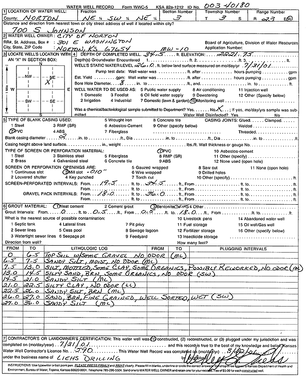
T3S, R23W, Sec. 3 NE SW NE |
City of Norton | 34.5 ft. | 26 ft. | Monitoring well/observation/piezometer | MW 10 | Constructed | 31-Jul-2001 | Scan | |
|
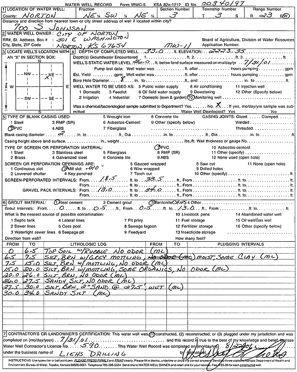
T3S, R23W, Sec. 3 NE SW NE |
City of Norton | 33 ft. | 26 ft. | Monitoring well/observation/piezometer | MW 11 | Constructed | 31-Jul-2001 | Scan | |
|
T3S, R23W, Sec. 3 NE SW NE |
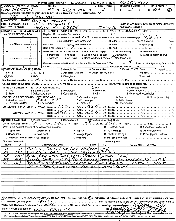
City of Norton | 27 ft. | 22.5 ft. | Monitoring well/observation/piezometer | MW 12 | Constructed | 31-Jul-2001 | Scan | |
|
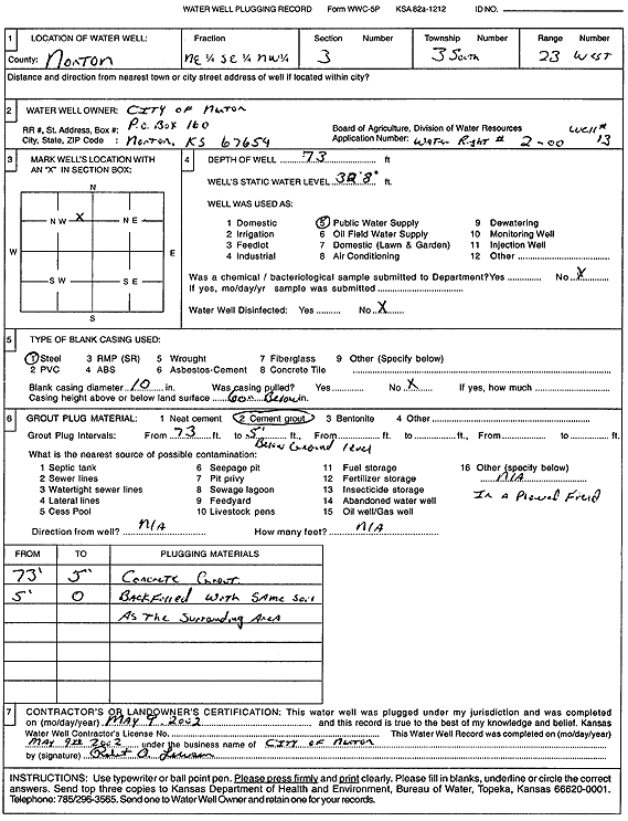
T3S, R23W, Sec. 3 NE SE NW |
City of Norton | 73 ft. | 32.67 ft. | Public Water Supply | Well 13 | Plugged | 09-May-2002 | Scan | |
|
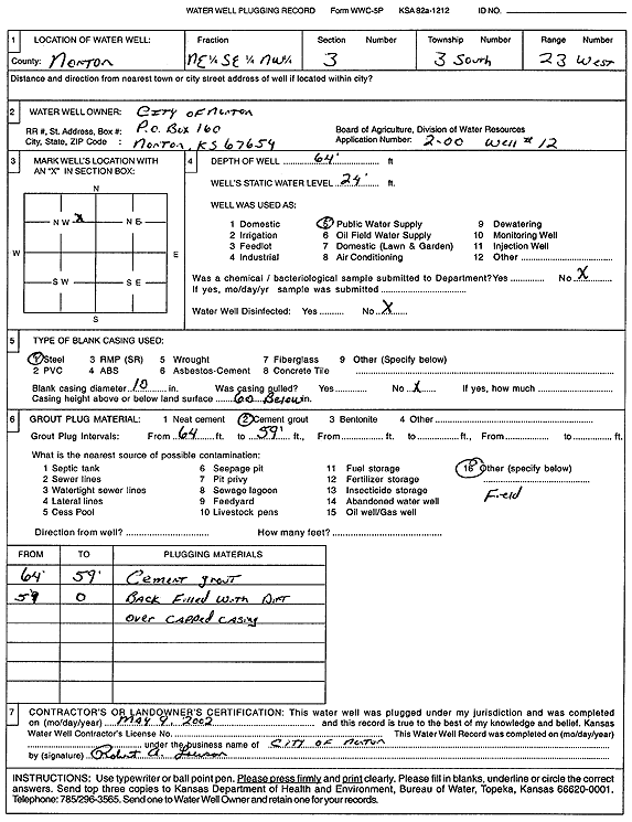
T3S, R23W, Sec. 3 NE SE NW |
City of Norton | 64 ft. | 24 ft. | Public Water Supply | Well 12 | Plugged | 09-May-2002 | Scan | |
|
T3S, R23W, Sec. 3 NW SE NW |
City of Norton | 70 ft. | 36 ft. | Public Water Supply | 17 | Plugged | 06-Jan-2010 | ||
|
T3S, R23W, Sec. 3 NE SW NE |
City of Norton | 33 ft. | Monitoring well/observation/piezometer | MW 11 | Plugged | 27-May-2008 | |||
|
T3S, R23W, Sec. 3 NW SW NW |
City of Norton | 70 ft. | 33 ft. | Public Water Supply | 11 | Plugged | 06-Jan-2010 | ||
|
T3S, R23W, Sec. 3 NW SW NW |
City of Norton | 73 ft. | 35 ft. | Public Water Supply | 20 | Plugged | 04-Feb-2010 | ||
|
T3S, R23W, Sec. 3 NE SW NW |
City of Norton | 70 ft. | 39 ft. | Public Water Supply | 18 | Plugged | 08-Jan-2010 | ||
|
T3S, R23W, Sec. 3 NW SW NW |
City of Norton | 82 ft. | 35 ft. | 350 gpm. | Public Water Supply | Constructed | 19-Nov-2009 | ||
|
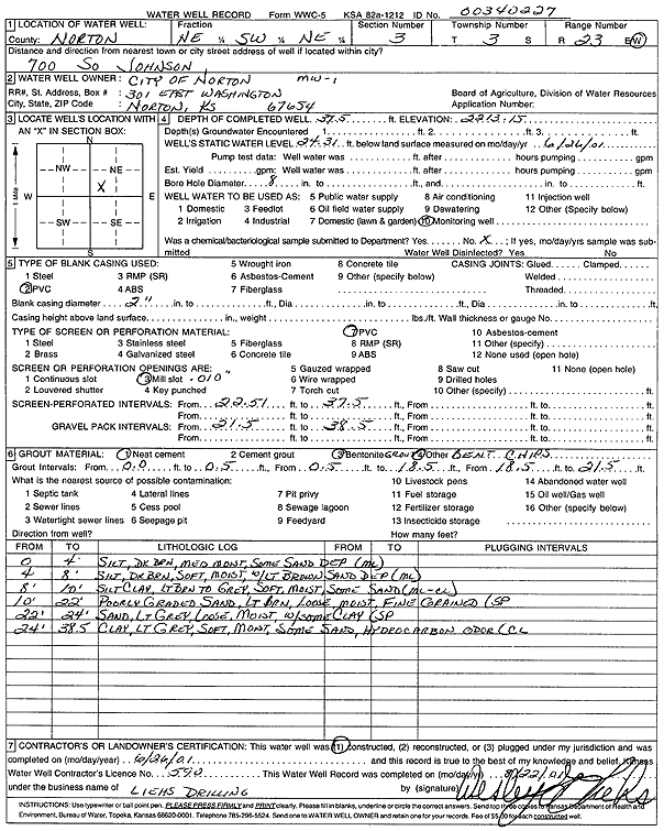
T3S, R23W, Sec. 3 NE SW NE |
City of Norton | 37.5 ft. | 24.31 ft. | Monitoring well/observation/piezometer | MW 1 | Constructed | 26-Jun-2001 | Scan | |
|
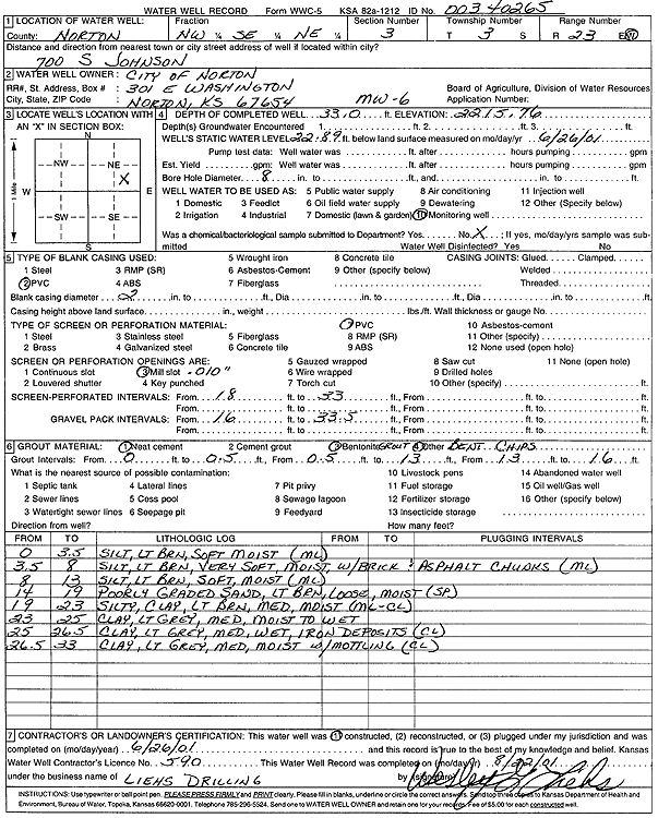
T3S, R23W, Sec. 3 NW SE NE |
City of Norton | 33 ft. | 22.89 ft. | Monitoring well/observation/piezometer | MW 6 | Constructed | 26-Jun-2001 | Scan | |
| View page: < Prev || 21 || 22 || 23 || 24 || 25 || 26 || 27 || 28 || 29 || 30 || Next > | |||||||||