Select location of well to view details.
Click on column heading to sort.
|
|
|
County: Phillips Select location of well to view details. Click on column heading to sort. |
|
|
|
| View page: < Prev || 31 || 32 || 33 || 34 || 35 || 36 | |||||||||
| T-R-S | Owner | Well Depth Ascend. Desc. |
Static Water Level Ascend. Desc. |
Est. Yield Ascend. Desc. |
Well Use | Other ID | Action Taken | Completion Date Ascend. Desc. |
Scan? |
|
T5S, R20W, Sec. 16 NE SW SW |
Wilkison, Ken | 38 ft. | 20 ft. | 40 gpm. | Domestic | Constructed | 23-Apr-1997 | ||
|
T5S, R20W, Sec. 19 NW SW SE |
Murfin Drilling Co. | 19.5 ft. | 12 ft. | Monitoring well/observation/piezometer | MW 2 | Plugged | 14-Nov-2012 | ||
|
T5S, R20W, Sec. 19 SW SW SE |
Murfin Drilling Co. | 22 ft. | 18 ft. | Monitoring well/observation/piezometer | MW 3 | Plugged | 14-Nov-2012 | ||
|
T5S, R20W, Sec. 19 SW NW SE |
Murfin Drilling Co. | 13.5 ft. | 11 ft. | Monitoring well/observation/piezometer | MW 1 | Plugged | 14-Nov-2012 | ||
|
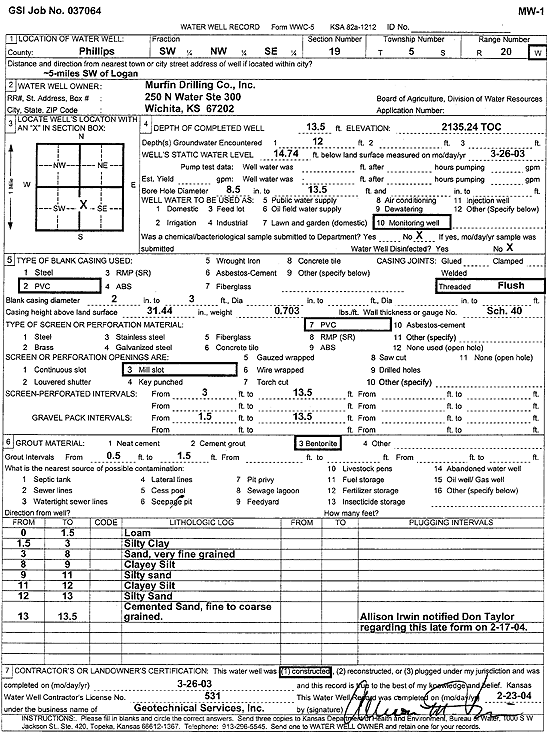
T5S, R20W, Sec. 19 SW NW SE |
Murfin Drilling Co. | 13.5 ft. | 14.74 ft. | Monitoring well/observation/piezometer | MW 1 | Constructed | 26-Mar-2003 | Scan | |
|
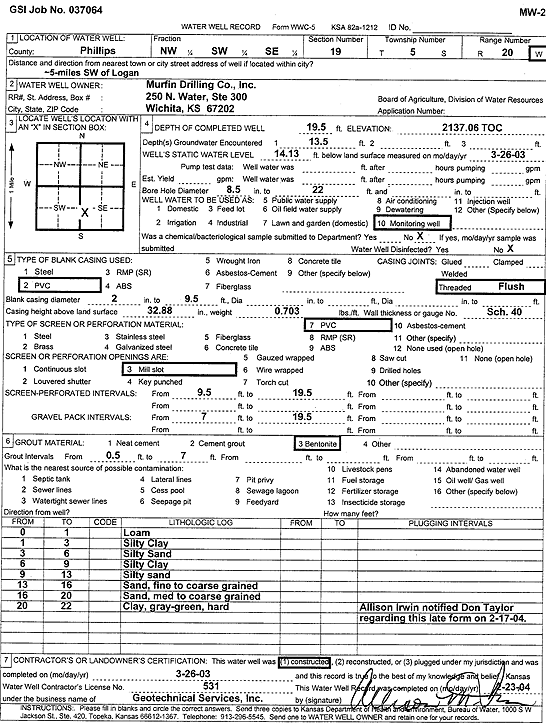
T5S, R20W, Sec. 19 NW SW SE |
Murfin Drilling Co. | 19.5 ft. | 14.13 ft. | Monitoring well/observation/piezometer | MW 2 | Constructed | 26-Mar-2003 | Scan | |
|
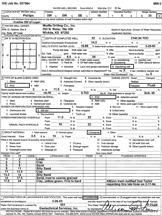
T5S, R20W, Sec. 19 SW SW SE |
Murfin Drilling Co. | 22 ft. | 19.86 ft. | Monitoring well/observation/piezometer | MW 3 | Constructed | 26-Mar-2003 | Scan | |
|
T5S, R20W, Sec. 20 NE NE SW |
Hansen Trust | 55 ft. | Domestic | Constructed | 01-Jun-2005 | ||||
|
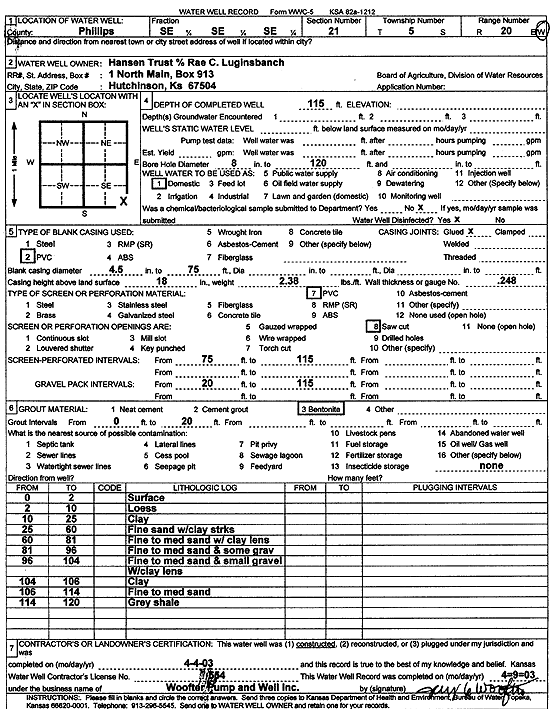
T5S, R20W, Sec. 21 SE SE SE |
Hansen Trust | 115 ft. | Domestic | Constructed | 04-Apr-2003 | Scan | |||
|
T5S, R20W, Sec. 23 NE NE SW |
Brown, Joyce | 90 ft. | 76 ft. | Domestic, Livestock | Constructed | 29-Mar-1983 | |||
|
T5S, R20W, Sec. 27 SE SW SW |
Wilkison, Kenny | 40 ft. | 22 ft. | 40 gpm. | Domestic | Constructed | 02-Aug-1989 | ||
|
T5S, R20W, Sec. 29 SE SE SE NW |
Dane Hansen Trust | 135 ft. | 100 ft. | 16 gpm. | Domestic, Livestock | Constructed | 27-Jun-2011 | ||
|
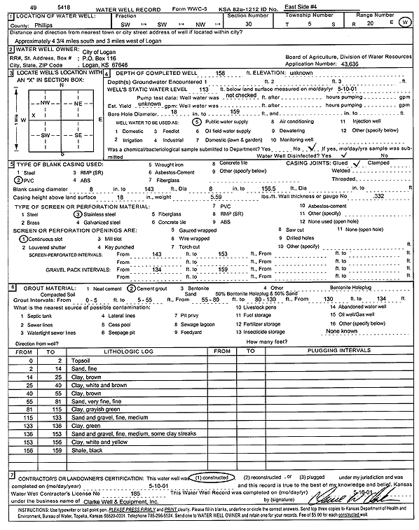
T5S, R20W, Sec. 30 SW SW NW |
City of Logan | 158 ft. | 113 ft. | Public Water Supply | East side 4 | Constructed | 10-May-2001 | Scan | |
|
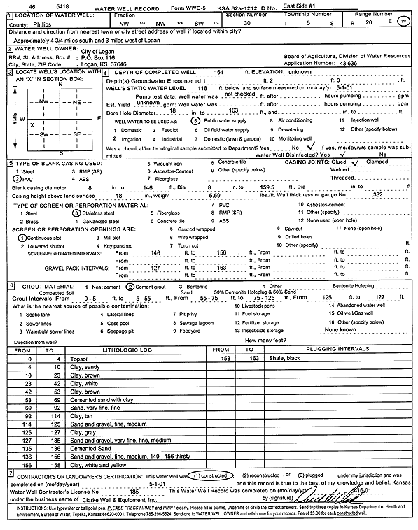
T5S, R20W, Sec. 30 NW NW SW |
City of Logan | 161 ft. | 118 ft. | Public Water Supply | East side 1 | Constructed | 01-May-2001 | Scan | |
|
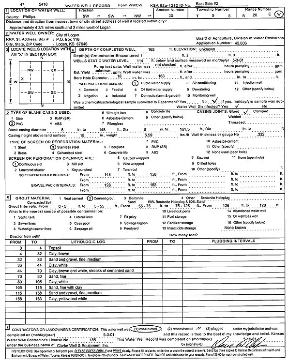
T5S, R20W, Sec. 30 SW SW NW |
City of Logan | 163 ft. | 114 ft. | Public Water Supply | East side 2 | Constructed | 03-May-2001 | Scan | |
|
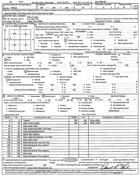
T5S, R20W, Sec. 30 SW SW NW |
City of Logan | 163 ft. | 115 ft. | Public Water Supply | East side 3 | Constructed | 09-May-2001 | Scan | |
|
T5S, R20W, Sec. 30 SE NW NE |
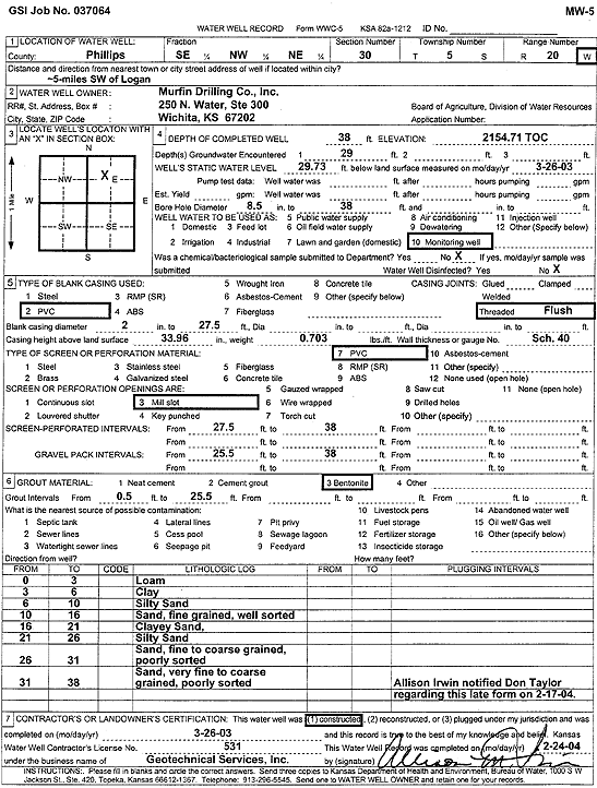
Murfin Drilling Co. | 38 ft. | 29.73 ft. | Monitoring well/observation/piezometer | MW 5 | Constructed | 26-Mar-2003 | Scan | |
|
T5S, R20W, Sec. 30 NW NW SE |
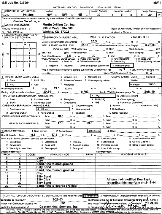
Murfin Drilling Co., Inc. | 29.5 ft. | 22.38 ft. | Monitoring well/observation/piezometer | MW 4 | Constructed | 26-Mar-2003 | Scan | |
|
T5S, R20W, Sec. 30 NW NW NE |
Murfin Drilling Co., Inc. | 29.5 ft. | 20.5 ft. | Monitoring well/observation/piezometer | MW 4 | Plugged | 14-Nov-2012 | ||
|
T5S, R20W, Sec. 30 SE NW NE |
Murfin Drilling Co., Inc. | 49.5 ft. | 37 ft. | Monitoring well/observation/piezometer | MW 6 | Plugged | 14-Nov-2012 | ||
|
T5S, R20W, Sec. 30 SE NW NE |
Murfin Drilling Co., Inc. | 38 ft. | 28 ft. | Monitoring well/observation/piezometer | MW 5 | Plugged | 14-Nov-2012 | ||
|
T5S, R20W, Sec. 32 S2 NE |
James E Carpenter Trust 1 | 90 ft. | Domestic | Constructed | 30-Jul-2008 | ||||
|
T5S, R20W, Sec. 32 SE SE NW NW |
States Enterprises | 118 ft. | 93 ft. | 15 gpm. | Domestic, Livestock | Constructed | 21-Dec-2012 | ||
|
T5S, R20W, Sec. 34 NW NW SW |
Gottschalk, Terrance | 68 ft. | 57 ft. | 18 gpm. | Domestic | Constructed | 21-Jul-2009 | ||
|
T5S, R20W, Sec. 36 SE SE SW |
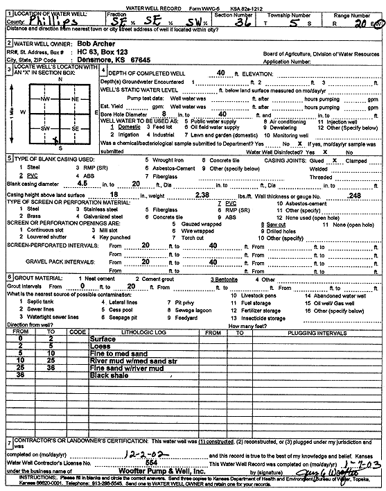
Archer, Bob | 40 ft. | Domestic | Constructed | 02-Dec-2002 | Scan | |||
| View page: < Prev || 31 || 32 || 33 || 34 || 35 || 36 | |||||||||