Select location of well to view details.
Click on column heading to sort.
|
|
|
County: Phillips Select location of well to view details. Click on column heading to sort. |
|
|
|
| View page: 1 || 2 || 3 || 4 || 5 || 6 || 7 || 8 || 9 || 10 || Next > | |||||||||
| T-R-S | Owner | Well Depth Ascend. Desc. |
Static Water Level Ascend. Desc. |
Est. Yield Ascend. Desc. |
Well Use | Other ID | Action Taken | Completion Date Ascend. Desc. |
Scan? |
|
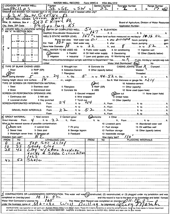
T2S, R17W, Sec. 22 SE SE SW |
Baily, Vernon | 52 ft. | 16.58 ft. | 10 gpm. | Domestic | Constructed | 16-Oct-2002 | Scan | |
|
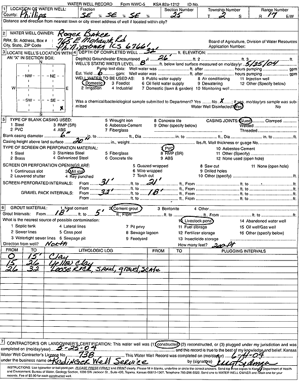
T2S, R17W, Sec. 25 SE SE SE |
Baker, Roger | 32 ft. | 8 ft. | 6 gpm. | Domestic | Constructed | 25-May-2004 | Scan | |
|
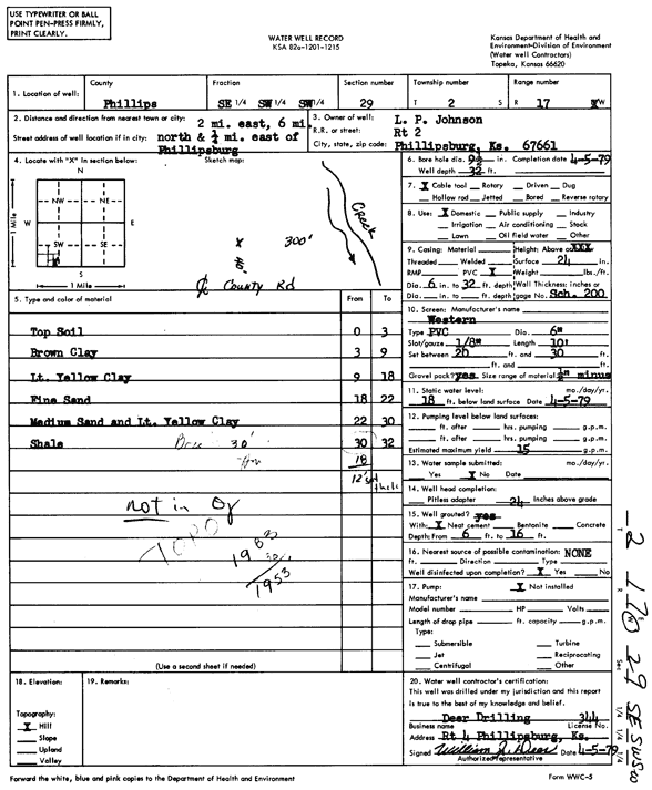
T2S, R17W, Sec. 29 SE SW SW |
Johnson, L.P. | 32 ft. | 18 ft. | 15 gpm. | Domestic | Constructed | 05-Apr-1979 | Scan | |
|
T2S, R17W, Sec. 30 NE NW NW |
Johnson, Kenneth | 22 ft. | 16 ft. | 2.5 gpm. | Domestic, Livestock | Constructed | 23-Nov-2004 | ||
|
T2S, R17W, Sec. 30 SW NW SE |
Taylor, Lee | 32.5 ft. | 19 ft. | 4 gpm. | Domestic | Constructed | 28-Dec-2004 | ||
|
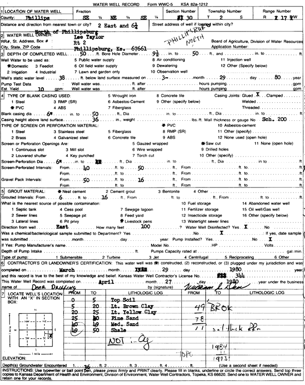
T2S, R17W, Sec. 30 SE NE SE |
Taylor, Lee | 50 ft. | 38 ft. | 10 gpm. | Domestic | Constructed | 29-Mar-1980 | Scan | |
|
T2S, R17W, Sec. 32 NE NW NW |
Johnson, Kenneth | 41 ft. | 26 ft. | 5 gpm. | Domestic, Livestock | Constructed | 06-Nov-2006 | ||
|
T2S, R17W, Sec. 33 SW NW NW |
Johnson, Ken | 31 ft. | 12 ft. | 6 gpm. | Domestic, Livestock | Constructed | 05-Nov-2005 | ||
|
T2S, R17W, Sec. 36 NE NE SE NW |
Baker, Roger | 45 ft. | 16 ft. | 3 gpm. | Domestic, Livestock | Constructed | 07-Dec-2015 |
KOLAR |
|
|
T2S, R17W, Sec. 36 NE NE SE |
Baker, Roger | 38 ft. | 21 ft. | Domestic, Livestock | Constructed | 21-Jul-2023 |
KOLAR |
||
|
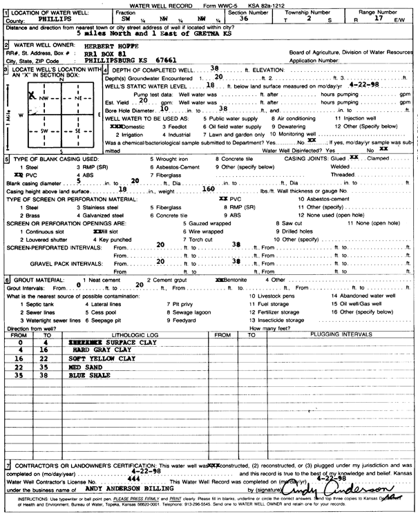
T2S, R17W, Sec. 36 SW NW NW |
Hoppe, Herbert | 38 ft. | 18 ft. | 20 gpm. | Domestic | Constructed | 22-Apr-1998 | Scan | |
|
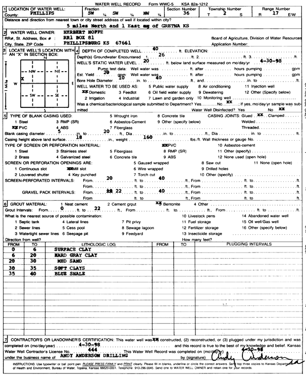
T2S, R17W, Sec. 36 SW SW NW |
Hoppe, Herbert | 40 ft. | 20 ft. | 20 gpm. | Domestic | Constructed | 30-Apr-1998 | Scan | |
|
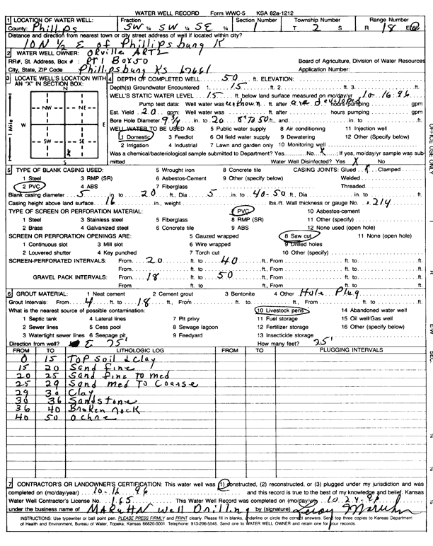
T2S, R18W, Sec. 1 SW SW SE |
Artz, Orville | 50 ft. | 15 ft. | 20 gpm. | Domestic | Constructed | 16-Oct-1996 | Scan | |
|
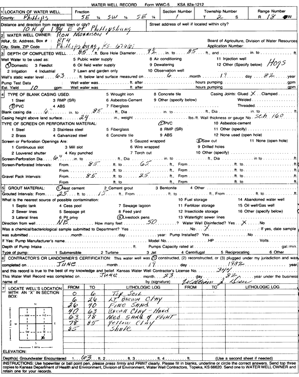
T2S, R18W, Sec. 1 SE SW SE |
Morrison, Ron | 85 ft. | 63 ft. | 10 gpm. | Domestic | Constructed | 19-Jun-1982 | Scan | |
|
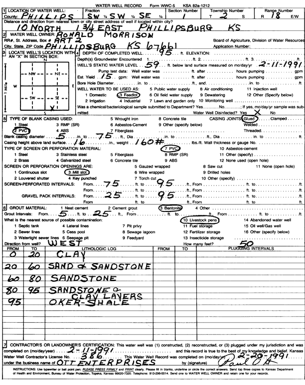
T2S, R18W, Sec. 1 SW SW SE |
Morrison, Ronald | 95 ft. | 59 ft. | 15 gpm. | Feedlot | Constructed | 11-Feb-1991 | Scan | |
|
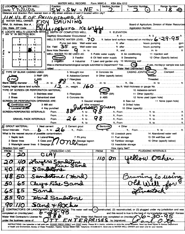
T2S, R18W, Sec. 2 SW SW NE |
Bruning, Floy | 98 ft. | 70 ft. | 35 gpm. | Domestic | Constructed | 28-Jun-1995 | Scan | |
|
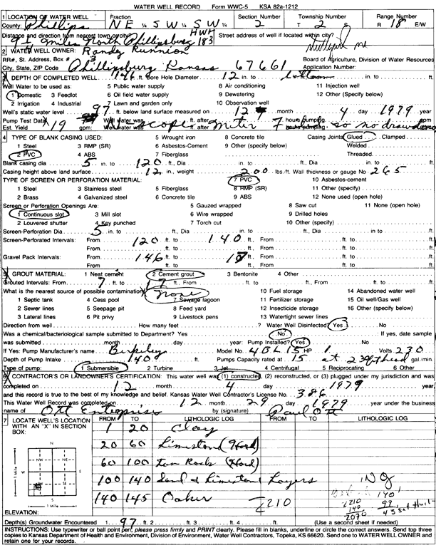
T2S, R18W, Sec. 2 NE SW SW |
Runnion, Randy | 146 ft. | 97 ft. | 19 gpm. | Domestic | Constructed | 04-Dec-1979 | Scan | |
|
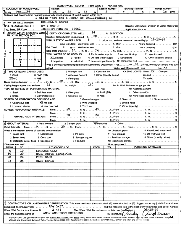
T2S, R18W, Sec. 2 NE SE SE |
Smith, Russell | 24 ft. | 8 ft. | 6 gpm. | Domestic | Constructed | 15-Oct-1997 | Scan | |
|
T2S, R18W, Sec. 3 NW NE NE |
Jackson, Rodney | 80 ft. | 65 ft. | Domestic, Livestock | Plugged | 13-Dec-2024 |
KOLAR |
||
|
T2S, R18W, Sec. 3 NW NE NE |
Jackson, Rodney | 115 ft. | 65 ft. | 10 gpm. | Domestic, Livestock | Constructed | 13-Dec-2024 |
KOLAR |
|
|
T2S, R18W, Sec. 3 SE SW |
Stapel, David | 180 ft. | 100 ft. | 20 gpm. | Domestic, Livestock | Constructed | 23-May-2011 | ||
|
T2S, R18W, Sec. 4 SE NE NE |
Jackson, Jerry | 170 ft. | 131 ft. | 10 gpm. | Domestic | Constructed | 15-Mar-2006 | ||
|
T2S, R18W, Sec. 5 NW NE NW |
Gebhard, Charles | 104 ft. | 3 gpm. | Domestic | Constructed | 25-Jun-2005 | |||
|
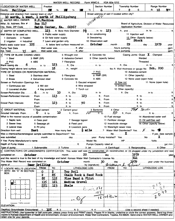
T2S, R18W, Sec. 6 SW NW NW |
Faubion, H.H. | 123 ft. | 105 ft. | 15 gpm. | Domestic, Livestock | Constructed | 20-Oct-1979 | Scan | |
|
T2S, R18W, Sec. 7 NW NW NW |
City of Phillipsburg | 103 ft. | 64.5 ft. | (unstated)/abandoned | Constructed | 23-Aug-2005 | |||
|
T2S, R18W, Sec. 7 NE NE NE |
City of Phillipsburg | 126 ft. | 32 ft. | (unstated)/abandoned | Constructed | 23-Aug-2005 | |||
|
T2S, R18W, Sec. 7 SW NE NE |
City of Phillipsburg | 162 ft. | 112.5 ft. | Domestic | Constructed | 25-Aug-2005 | |||
|
T2S, R18W, Sec. 7 NW NE NW |
City of Phillipsburg | 148 ft. | 109 ft. | (unstated)/abandoned | Constructed | 18-Aug-2005 | |||
|
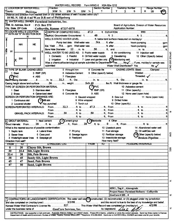
T2S, R18W, Sec. 7 NW SW SW |
Farmland Industries Inc. | 47.3 ft. | Monitoring well/observation/piezometer | MW 1 | Constructed | 03-Mar-1998 | Scan | ||
|
T2S, R18W, Sec. 11 NW NW NW NW |
Bruning, Floy | 175 ft. | 85 ft. | 12 gpm. | Domestic, Livestock | Constructed | 22-May-2014 | ||
|
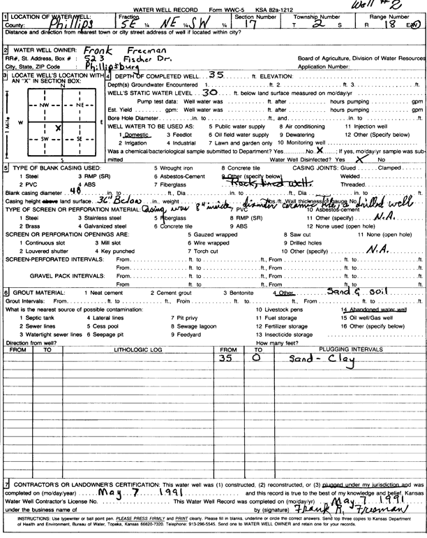
T2S, R18W, Sec. 17 SE NE SW |
Freeman, Frank | 35 ft. | 30 ft. | Domestic | Plugged | 07-May-1991 | Scan | ||
|
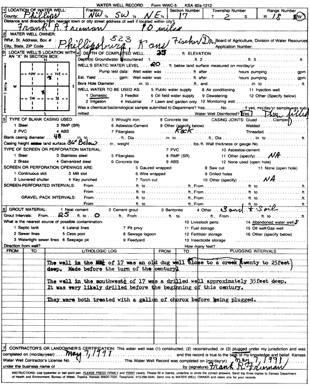
T2S, R18W, Sec. 17 NW SW NE |
Freeman, Frank | 25 ft. | 20 ft. | Domestic | Plugged | 07-May-1991 | Scan | ||
|
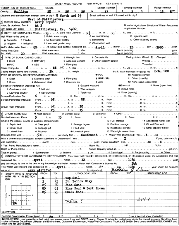
T2S, R18W, Sec. 17 SE SW SW |
Hopson, Avery | 95 ft. | 80 ft. | 20 gpm. | Domestic | Constructed | 12-Apr-1980 | Scan | |
|
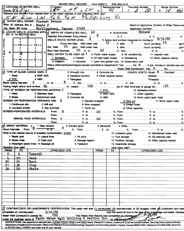
T2S, R18W, Sec. 21 NW NE SW |
Peters, Forrest | 40 ft. | 8 ft. | 10 gpm. | Domestic | Constructed | 30-Jun-1988 | Scan | |
|
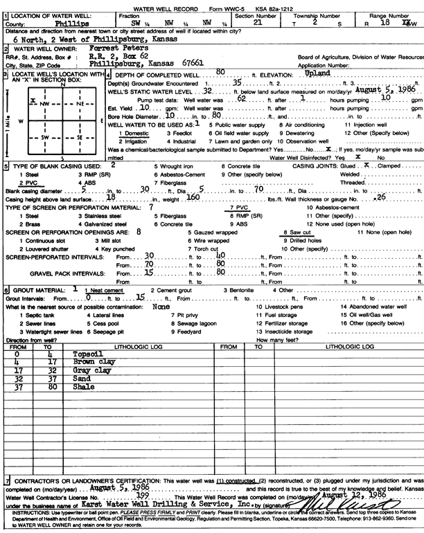
T2S, R18W, Sec. 21 SW NW NW |
Peters, Forrest | 80 ft. | 32 ft. | 10 gpm. | Domestic | Constructed | 05-Aug-1986 | Scan | |
|
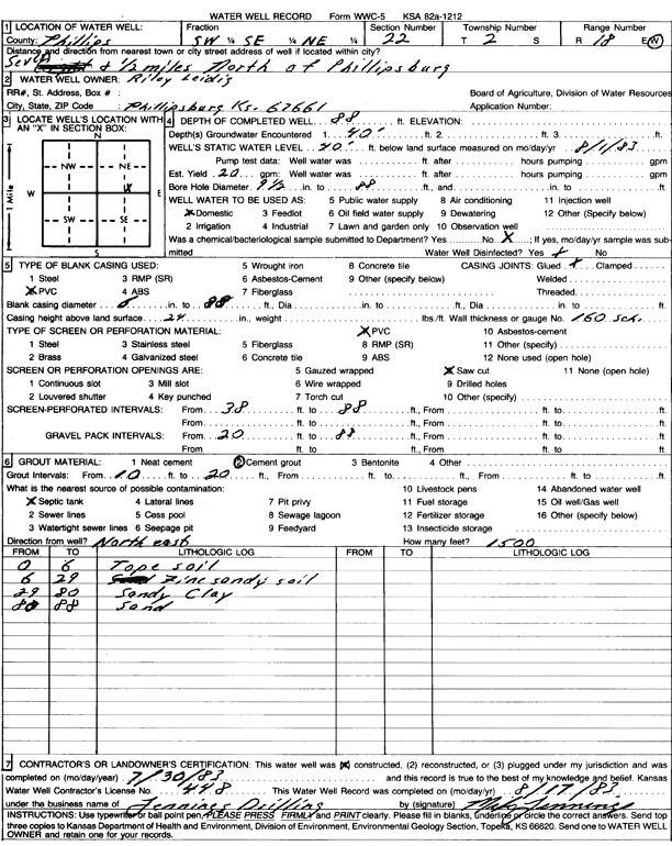
T2S, R18W, Sec. 22 SW SE NE |
Leidig, Riley | 88 ft. | 40 ft. | 20 gpm. | Domestic | Constructed | 30-Jul-1983 | Scan | |
|
T2S, R18W, Sec. 23 NE NE SW |
Johnson, Neil and Norma | 38 ft. | Domestic | Plugged | 27-May-1991 | ||||
|
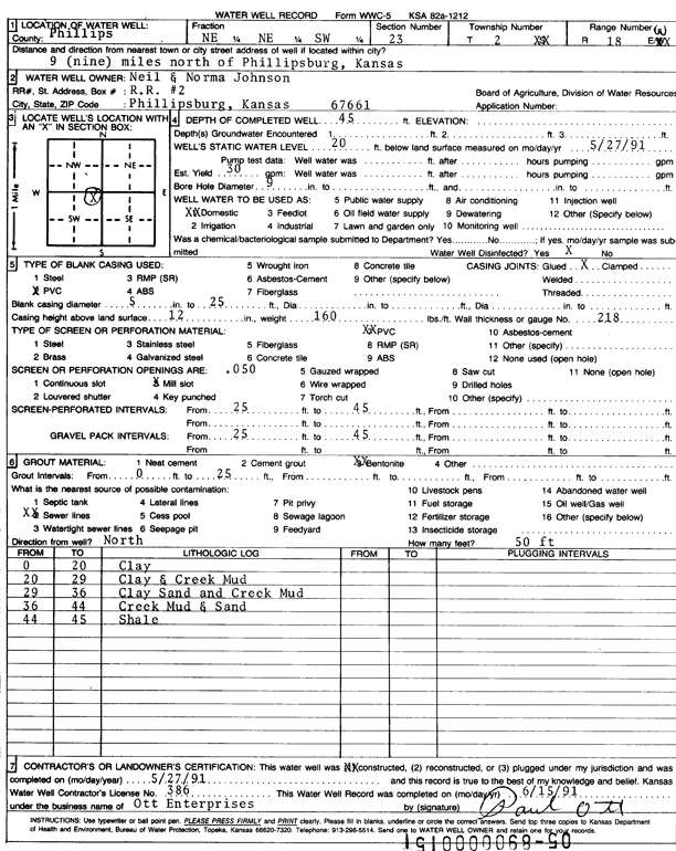
T2S, R18W, Sec. 23 NE NE SW |
Johnson, Neil and Norma | 45 ft. | 20 ft. | 30 gpm. | Domestic | Constructed | 27-May-1991 | Scan | |
|
T2S, R18W, Sec. 23 SE SE NW |
Morrison, Ron | 54 ft. | 28 ft. | Domestic | well 2 | Constructed | 18-Sep-2004 | ||
|
T2S, R18W, Sec. 23 SE SE NW |
Morrison, Ron | 44 ft. | 9 ft. | 3 gpm. | Domestic | well 1 | Constructed | 19-Sep-2004 | |
|
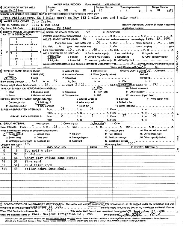
T2S, R18W, Sec. 25 NW NW SW |
Taylor, Tony | 59 ft. | 30 ft. | Domestic | Constructed | 25-Sep-2001 | Scan | ||
|
T2S, R18W, Sec. 27 NE NW SE |
Coffeyville Resources Terminal, LLC | 35 ft. | Monitoring well/observation/piezometer | J 3 | Constructed | 05-Jun-2009 | |||
|
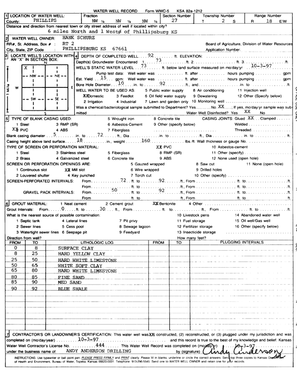
T2S, R18W, Sec. 27 NW NW NW |
Schurz, Hank | 92 ft. | 73 ft. | 15 gpm. | Domestic | Constructed | 03-Oct-1997 | Scan | |
|
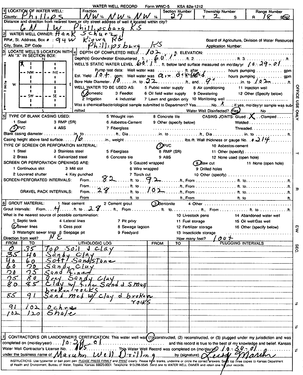
T2S, R18W, Sec. 27 NW NW NW |
Schurz, Hank | 102 ft. | 60.08 ft. | 10 gpm. | Domestic | Constructed | 29-Oct-2001 | Scan | |
|
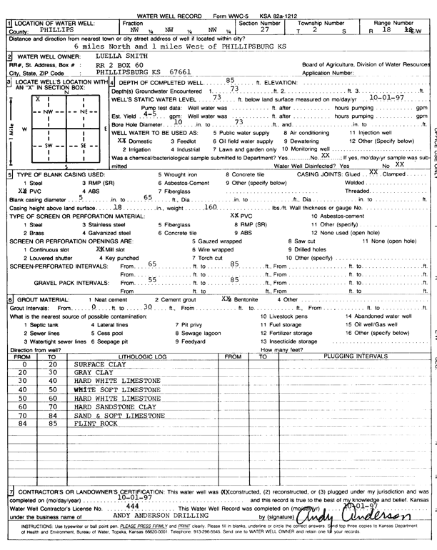
T2S, R18W, Sec. 27 NW NW NW |
Smith, Luella | 85 ft. | 73 ft. | 4 gpm. | Domestic | Constructed | 01-Oct-1997 | Scan | |
|
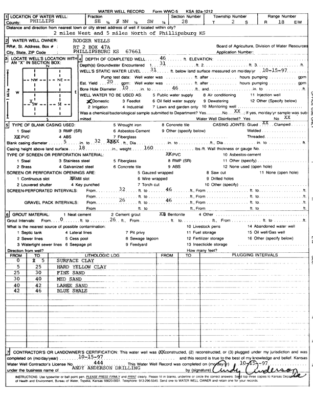
T2S, R18W, Sec. 28 SE NW SW |
Wells, Roger | 46 ft. | 31 ft. | 20 gpm. | Domestic | Constructed | 15-Oct-1997 | Scan | |
|
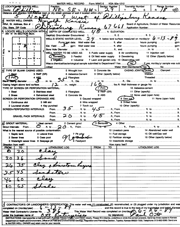
T2S, R18W, Sec. 29 NE SE NW |
Kaiser, Harold | 45 ft. | 24 ft. | 5 gpm. | Domestic | Constructed | 13-Jun-1989 | Scan | |
|
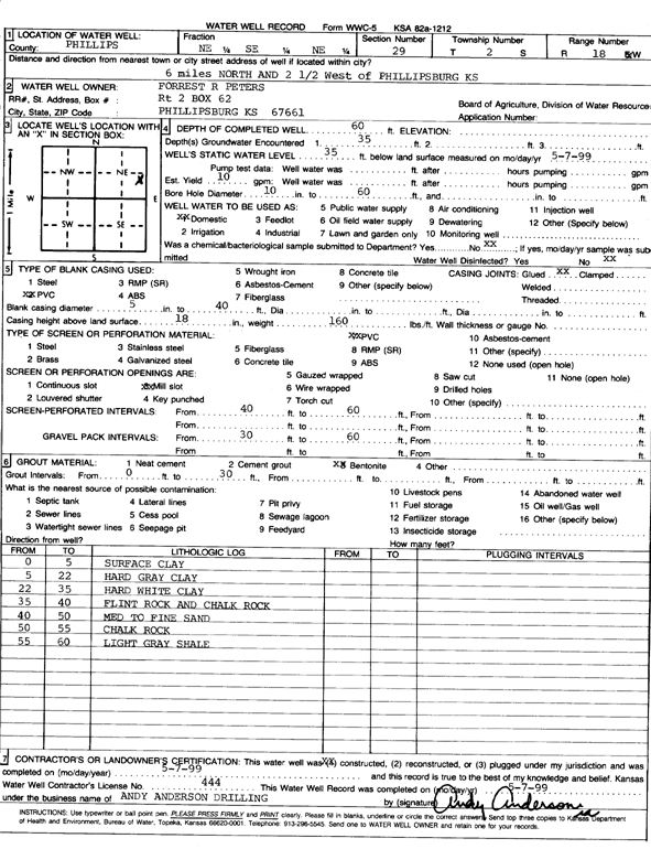
T2S, R18W, Sec. 29 NE SE NE |
Peters, Forrest R. | 60 ft. | 35 ft. | 10 gpm. | Domestic | Constructed | 07-May-1999 | Scan | |
|
T2S, R18W, Sec. 30 SW SW NW NW |
Waggoner, Rick | 39 ft. | 21 ft. | 12 gpm. | Domestic, Livestock | Constructed | 15-Jun-2013 | ||
|
T2S, R18W, Sec. 31 SW NW SW |
Leonard, Dennis | 75 ft. | 14 ft. | 1 gpm. | Domestic, Livestock | Constructed | 10-Oct-2023 |
KOLAR |
|
| View page: 1 || 2 || 3 || 4 || 5 || 6 || 7 || 8 || 9 || 10 || Next > | |||||||||