Select location of well to view details.
Click on column heading to sort.
|
|
|
County: Pottawatomie Select location of well to view details. Click on column heading to sort. |
|
|
|
| View page: < Prev || 51 || 52 || 53 || 54 || 55 || 56 || 57 || 58 || 59 | |||||||||
| T-R-S | Owner | Well Depth Ascend. Desc. |
Static Water Level Ascend. Desc. |
Est. Yield Ascend. Desc. |
Well Use | Other ID | Action Taken | Completion Date Ascend. Desc. |
Scan? |
|
T10S, R12E, Sec. 10 NE NW SW SE |
Zapp, Paul | 43.25 ft. | 29.55 ft. | Monitoring well/observation/piezometer | MW 1 R | Constructed | 16-Feb-2017 | ||
|
T10S, R12E, Sec. 10 NE NW SW SE |
Zapp, Paul | 33.2 ft. | 18.93 ft. | Monitoring well/observation/piezometer | MW 10 | Constructed | 14-Feb-2017 | ||
|
T10S, R12E, Sec. 10 NW NW SW SE |
Zapp, Paul | 43.93 ft. | 27.73 ft. | Monitoring well/observation/piezometer | MW 8 | Constructed | 13-Feb-2017 | ||
|
T10S, R12E, Sec. 10 NW SW SE |
Zapp, Paul | 36.8 ft. | Monitoring well/observation/piezometer | MW 7 | Plugged | 14-May-2014 | |||
|
T10S, R12E, Sec. 10 NW SW SE |
Zapp, Paul | 36.65 ft. | Monitoring well/observation/piezometer | MW 4 | Plugged | 14-May-2014 | |||
|
T10S, R12E, Sec. 10 NW SW SE |
Zapp, Paul | 33.6 ft. | Monitoring well/observation/piezometer | MW 2 | Plugged | 14-May-2014 | |||
|
T10S, R12E, Sec. 10 NW SW SE |
Zapp, Paul | 35.5 ft. | 28.5 ft. | Monitoring well/observation/piezometer | MW 6 | Constructed | 26-Jun-2008 | ||
|
T10S, R12E, Sec. 10 NW SW SE |
Zapp, Paul | 37 ft. | 26.8 ft. | Monitoring well/observation/piezometer | MW 7 | Constructed | 26-Jun-2008 | ||
|
T10S, R12E, Sec. 10 NE NW SW SE |
Zapp, Paul | 43.84 ft. | 29.47 ft. | Monitoring well/observation/piezometer | MW 7 R | Constructed | 16-Feb-2017 | ||
|
T10S, R12E, Sec. 11 C SE SE |
City of St Marys | 58 ft. | 31 ft. | 200 gpm. | Irrigation | Constructed | 12-Aug-1994 | ||
|
T10S, R12E, Sec. 11 NE NE NW |
Ells, Gary | 60 ft. | 35 ft. | 2 gpm. | Domestic | Constructed | 04-Aug-1978 | ||
|
T10S, R12E, Sec. 11 SW SW SW |
St Marys State Bank | 46 ft. | 30 ft. | 50 gpm. | Domestic, Lawn and Garden | Constructed | 06-Mar-1997 | ||
|
T10S, R12E, Sec. 14 SE SE NE |
Brunin, Bill | 38 ft. | 10 ft. | 1050 gpm. | Irrigation | Constructed | 02-Jun-1976 | ||
|
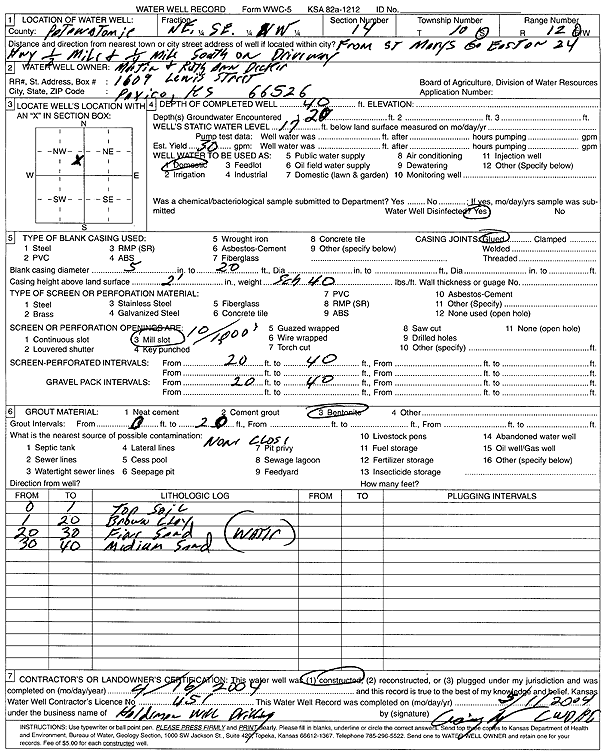
T10S, R12E, Sec. 14 NE SE NW |
Decker, Martin and Ruth Ann | 40 ft. | 17 ft. | 30 gpm. | Domestic | Constructed | 16-Apr-2004 | Scan | |
|
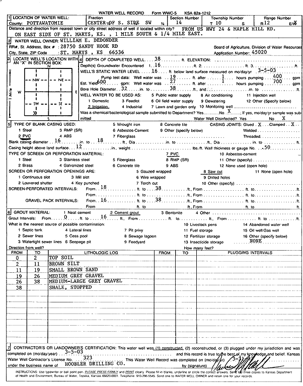
T10S, R12E, Sec. 14 C S2 SW |
Dedonder, William E. | 38 ft. | 16 ft. | 600 gpm. | Irrigation | Constructed | 05-Mar-2003 | Scan | |
|
T10S, R12E, Sec. 14 SE SE NW |
Garrett, Jim | 40 ft. | 20 ft. | 20 gpm. | Domestic | Constructed | 28-Apr-1989 | ||
|
T10S, R12E, Sec. 14 NE SE NW |
Kolde Concrete | 46 ft. | 20 ft. | 50 gpm. | Domestic | Constructed | 26-Dec-1996 | ||
|
T10S, R12E, Sec. 14 NW NW NW NE |
Moats, Nick | 91 ft. | 30 ft. | .5 gpm. | Domestic | Constructed | 02-May-2020 |
KOLAR |
|
|
T10S, R12E, Sec. 14 C E2 NW |
Murphy, Dennis | 60 ft. | 20 ft. | 2 gpm. | Domestic | Constructed | 27-Jun-1988 | ||
|
T10S, R12E, Sec. 14 SW SW SW |
Vanderputten, John and Diane | 46 ft. | 21 ft. | 40 gpm. | Domestic | Constructed | 21-Sep-1989 | ||
|
T10S, R12E, Sec. 14 SE NW NW |
Vanderputten, John W. | 48 ft. | 19 ft. | 50 gpm. | Domestic | Constructed | 15-Nov-1995 | ||
|
T10S, R12E, Sec. 14 NE NE NW |
Wiltz, Mike | 47 ft. | 20 ft. | 50 gpm. | Domestic | Constructed | 14-Sep-1996 | ||
|
T10S, R12E, Sec. 15 NW NW NE |
City of St Marys | 47 ft. | 21 ft. | 1200 gpm. | Public Water Supply | Constructed | 25-Apr-1984 | ||
|
T10S, R12E, Sec. 15 SE NE NE |
City of St Marys | 44 ft. | 20 ft. | Public Water Supply | Well 8 | Constructed | 12-Aug-2003 | ||
|
T10S, R12E, Sec. 15 NW NE NE |
Leisler Oil Co. | 30 ft. | 24.34 ft. | Monitoring well/observation/piezometer | MW 9 | Constructed | 02-Sep-2025 |
KOLAR |
|
|
T10S, R12E, Sec. 15 SW SE SW SE |
Lindstrom, Jim | 85 ft. | 17 ft. | 1000 gpm. | Irrigation | Constructed | 02-Mar-2021 |
KOLAR |
|
|
T10S, R12E, Sec. 15 NE SW NE |
MCM Properties | 46 ft. | 13.5 ft. | (unstated)/abandoned | Plugged | 01-Nov-2005 | |||
|
T10S, R12E, Sec. 15 C NW |
Minnis, Winifred V. | 41 ft. | 18 ft. | 750 gpm. | Irrigation | Constructed | 28-Jul-1995 | ||
|
T10S, R12E, Sec. 15 C NW |
Minnis, Winnifred V. | 41 ft. | 19 ft. | 750 gpm. | Irrigation | Constructed | 25-Aug-2002 | ||
|
T10S, R12E, Sec. 15 NW NW NW NW |
Rogelia, Gil | 37 ft. | 13 ft. | 30 gpm. | Domestic | Constructed | 17-May-2019 |
KOLAR |
|
|
T10S, R12E, Sec. 15 C NW NE |
USD 321 | 42 ft. | 23 ft. | 200 gpm. | Irrigation | Constructed | 04-May-1989 | ||
|
T10S, R12E, Sec. 22 E2 SE SE |
Brunin, Eugene J. | 68 ft. | 25 ft. | 2000 gpm. | Irrigation | Constructed | 21-Jul-1976 | ||
|
T10S, R12E, Sec. 22 NW SE NE |
MCM Properties LLC | 80 ft. | Irrigation | Constructed | 03-Mar-2009 | ||||
|
T10S, R12E, Sec. 23 C N2 |
Meyer, Clarence | 69 ft. | 16 ft. | 2000 gpm. | Irrigation | Constructed | 15-Oct-1976 | ||
|
T10S, R12E, Sec. 23 SE NW SW |
Parr, Howard | 72 ft. | 18 ft. | Irrigation | Plugged | 15-Jun-2023 |
KOLAR |
||
|
T10S, R12E, Sec. 23 NE NW SW |
Parr, Howard | 75 ft. | 15 ft. | Irrigation | Constructed | 14-Dec-2021 |
KOLAR |
||
|
T10S, R12E, Sec. 26 C NW |
Dedonder Farms | 62 ft. | 14 ft. | 2000 gpm. | Irrigation | Constructed | 30-Oct-1993 | ||
|
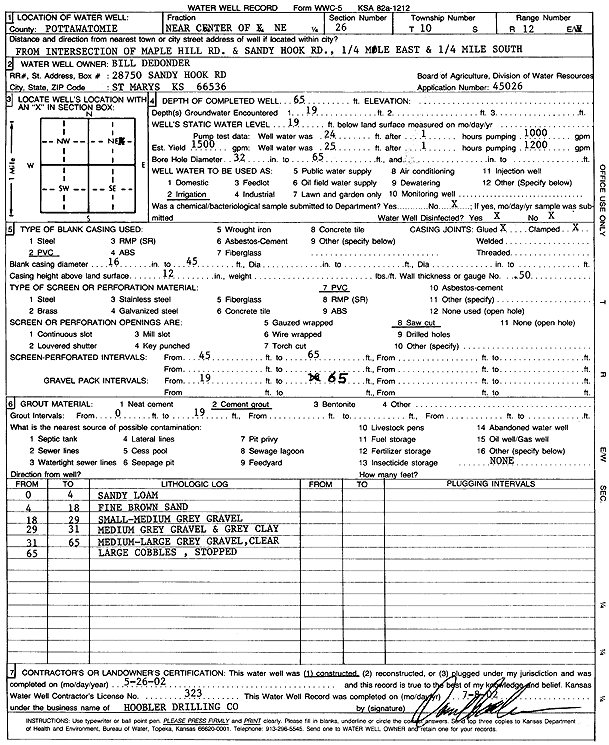
T10S, R12E, Sec. 26 NE |
Dedonder, Bill | 65 ft. | 19 ft. | 1500 gpm. | Irrigation | Constructed | 26-May-2002 | Scan | |
|
T10S, R12E, Sec. 26 NE NE NE |
Schoemann, Henry | 55 ft. | 18 ft. | 60 gpm. | Domestic | Constructed | 20-Feb-1991 | ||
|
T10S, R12E, Sec. 27 C SW |
Pessemier Co. | 41 ft. | 13 ft. | 1500 gpm. | Irrigation | Constructed | 21-Feb-1989 | ||
|
T10S, R12E, Sec. 27 C NW |
Royer, Christian | 62 ft. | 19 ft. | 2000 gpm. | Irrigation | Constructed | 19-May-1989 | ||
|
T10S, R12E, Sec. 28 C N2 NE |
Fally, Bert | 66 ft. | 22 ft. | 1200 gpm. | Irrigation | Constructed | 21-Jan-1992 | ||
|
T10S, R12E, Sec. 28 SE SE NE |
J.B. Farms | 47 ft. | 19 ft. | 2000 gpm. | Irrigation | Constructed | 21-Apr-1976 | ||
|
T10S, R12E, Sec. 28 SW SW NE NW |
Royer, Chris | 46 ft. | 11 ft. | 800 gpm. | Irrigation | Constructed | 23-Dec-2016 |
KOLAR |
|
|
T10S, R12E, Sec. 28 C NW |
Royer, Frances B. | 47 ft. | 12 ft. | 700 gpm. | Irrigation | Constructed | 27-Oct-1993 | ||
|
T10S, R12E, Sec. 35 NE |
Hesse, F. Burns | 36 ft. | 11 ft. | 700 gpm. | Irrigation | Constructed | 20-May-2005 | ||
|
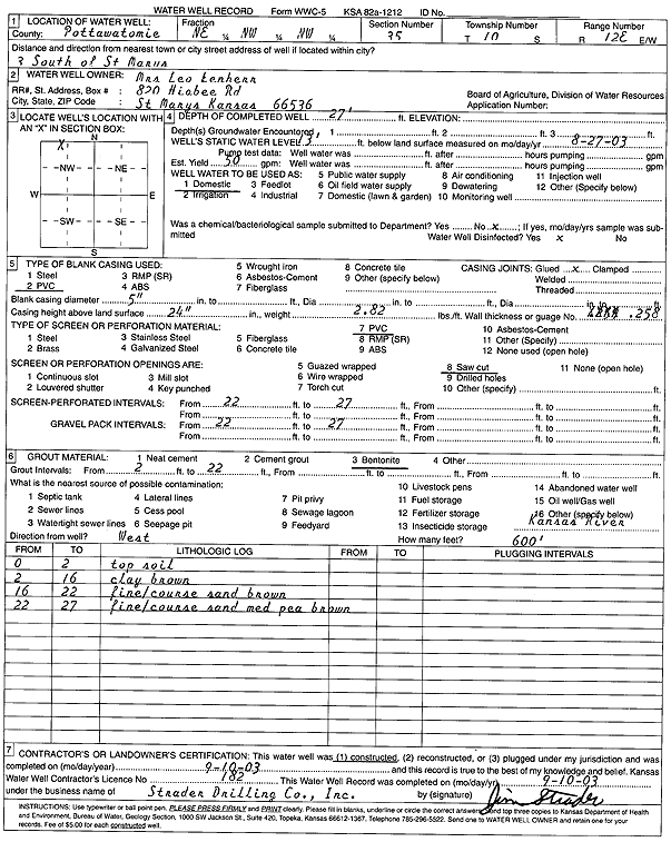
T10S, R12E, Sec. 35 NE NW NW |
Lenherr | 27 ft. | 13 ft. | 50 gpm. | Domestic | Constructed | 10-Sep-2003 | Scan | |
|
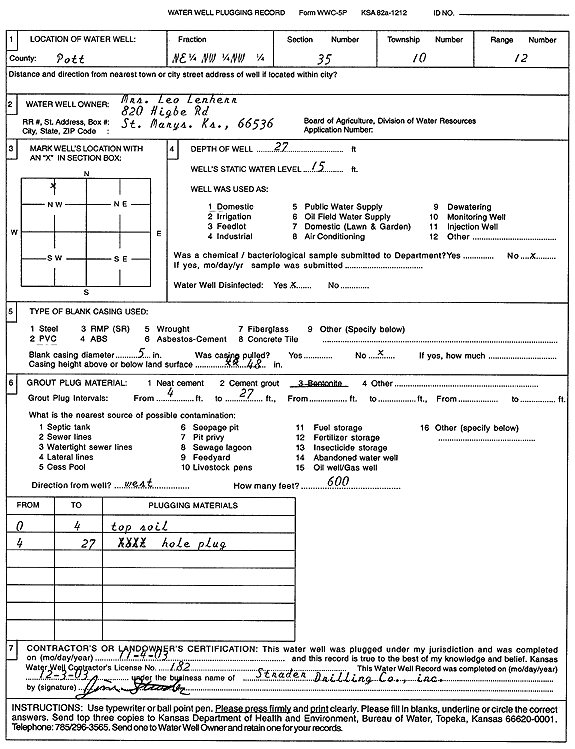
T10S, R12E, Sec. 35 NE NW NW |
Lenherr | 27 ft. | 15 ft. | Domestic | Plugged | 04-Nov-2003 | Scan | ||
|
T10S, R12E, Sec. 35 NW NW NE |
Versahelden, A.T. | 40 ft. | 20 ft. | 50 gpm. | Domestic | Constructed | 19-Mar-1981 | ||
| View page: < Prev || 51 || 52 || 53 || 54 || 55 || 56 || 57 || 58 || 59 | |||||||||