Select location of well to view details.
Click on column heading to sort.
|
|
|
County: Butler Select location of well to view details. Click on column heading to sort. |
|
|
|
| View page: < Prev || 51 || 52 || 53 || 54 || 55 || 56 || 57 || 58 || 59 || 60 || Next > | |||||||||
| T-R-S | Owner | Well Depth Ascend. Desc. |
Static Water Level Ascend. Desc. |
Est. Yield Ascend. Desc. |
Well Use | Other ID | Action Taken | Completion Date Ascend. Desc. |
Scan? |
|
T26S, R5E, Sec. 15 SW SW NW |
Getty Refining and Marketing Co. | 94.7 ft. | 10.1 ft. | Monitoring well/observation/piezometer | MW 22 | Constructed | 12-Sep-1978 | ||
|
T26S, R5E, Sec. 15 SW NW NW |
Getty Refining and Marketing Co. | 71.1 ft. | 17.9 ft. | Monitoring well/observation/piezometer | MW 30 | Constructed | 09-Oct-1978 | ||
|
T26S, R5E, Sec. 15 NE NW NW |
Getty Refining and Marketing Co. | 37 ft. | 15.6 ft. | Monitoring well/observation/piezometer | MW 73 | Constructed | 06-Dec-1978 | ||
|
T26S, R5E, Sec. 15 NE NE NE |
Getty Refining and Marketing Co. | 15.08 ft. | 6.53 ft. | 25 gpm. | Environmental Remediation, Recovery | ER 8 | Constructed | 11-Mar-1981 | |
|
T26S, R5E, Sec. 15 NE SW NW |
Getty Refining and Marketing Co. | 77.7 ft. | 24.7 ft. | Monitoring well/observation/piezometer | MW 24 | Constructed | 13-Sep-1978 | ||
|
T26S, R5E, Sec. 15 NE NE NE |
Getty Refining and Marketing Co. | 49.7 ft. | 13.6 ft. | Monitoring well/observation/piezometer | MW 15 | Constructed | 27-Sep-1978 | ||
|
T26S, R5E, Sec. 15 NE NW NE |
Getty Refining and Marketing Co. | 31 ft. | 11.6 ft. | Monitoring well/observation/piezometer | MW 27A | Constructed | 25-Sep-1978 | ||
|
T26S, R5E, Sec. 15 NE NE NE |
Getty Refining and Marketing Co. | 18.1 ft. | 9 ft. | Monitoring well/observation/piezometer | OE 9 | Constructed | 17-Mar-1981 | ||
|
T26S, R5E, Sec. 15 SW SW NW |
Getty Refining and Marketing Co. | 67.8 ft. | 11.6 ft. | Monitoring well/observation/piezometer | MW 19 | Constructed | 12-Sep-1978 | ||
|
T26S, R5E, Sec. 15 NE NW NW |
Getty Refining and Marketing Co. | 84.5 ft. | 22.3 ft. | Monitoring well/observation/piezometer | MW 29 | Constructed | 09-Oct-1978 | ||
|
T26S, R5E, Sec. 15 NE NE NE |
Getty Refining and Marketing Co. | 31.2 ft. | 13.1 ft. | Monitoring well/observation/piezometer | OE 11 | Constructed | 17-Mar-1981 | ||
|
T26S, R5E, Sec. 15 NE NE NE |
Getty Refining and Marketing Co. | 27 ft. | 8.2 ft. | 10 gpm. | Environmental Remediation, Recovery | ER 10 | Constructed | 09-Mar-1981 | |
|
T26S, R5E, Sec. 15 NE NE NE |
Getty Refining and Marketing Co. | 28 ft. | 7.7 ft. | Monitoring well/observation/piezometer | OE 10 | Constructed | 17-Mar-1981 | ||
|
T26S, R5E, Sec. 15 NW NW NW |
Getty Refining and Marketing Co. | 79.1 ft. | 17.3 ft. | Monitoring well/observation/piezometer | MW 31 | Constructed | 11-Sep-1978 | ||
|
T26S, R5E, Sec. 15 NW NW NW |
Getty Refining and Marketing Co. | 40.2 ft. | 22.3 ft. | Monitoring well/observation/piezometer | MW 77 | Constructed | 04-Dec-1978 | ||
|
T26S, R5E, Sec. 15 NW NW NW |
Getty Refining and Marketing Co. | 40 ft. | 22.3 ft. | Monitoring well/observation/piezometer | MW 78 | Constructed | 05-Dec-1978 | ||
|
T26S, R5E, Sec. 15 NW NW NW |
Getty Refining and Marketing Co. | 77.1 ft. | 11.2 ft. | Monitoring well/observation/piezometer | MW 45 | Constructed | 06-Sep-1978 | ||
|
T26S, R5E, Sec. 15 NW SW NW |
Getty Refining and Marketing Co. | 28 ft. | 4 ft. | Monitoring well/observation/piezometer | MW 79 | Constructed | 06-Dec-1978 | ||
|
T26S, R5E, Sec. 15 NE NE NE |
Getty Refining and Marketing Co. | 16 ft. | 7.15 ft. | 30 gpm. | Environmental Remediation, Recovery | ER 9 | Constructed | 11-Mar-1981 | |
|
T26S, R5E, Sec. 15 SE NE NE |
Getty Refining and Marketing Co. | 31 ft. | 19.6 ft. | Monitoring well/observation/piezometer | MW 88 | Constructed | 10-Aug-1979 | ||
|
T26S, R5E, Sec. 15 NE SE NE |
Getty Refining and Marketing Co. | 46 ft. | 20 ft. | Monitoring well/observation/piezometer | MW 9 | Constructed | 09-Oct-1978 | ||
|
T26S, R5E, Sec. 15 NW SE NW |
Getty Refining and Marketing Co. | 72.6 ft. | 27.5 ft. | Monitoring well/observation/piezometer | MW 25 | Constructed | 01-Mar-1978 | ||
|
T26S, R5E, Sec. 15 SW SW SW |
Monoze, Manual | 127 ft. | 25 ft. | 50 gpm. | Domestic, Lawn and Garden | Constructed | 24-Oct-2005 | ||
|
T26S, R5E, Sec. 15 SE SE NW |
Texaco Refining and Marketing, Inc. | 25 ft. | (unstated)/abandoned | W 4 | Plugged | 18-Sep-1997 | |||
|
T26S, R5E, Sec. 15 SE SE NE |
Texaco Refining and Marketing, Inc. | 23.7 ft. | (unstated)/abandoned | W 9 | Plugged | 19-Sep-1997 | |||
|
T26S, R5E, Sec. 15 SE SE SE |
Texaco Refining and Marketing, Inc. | 37 ft. | 20 ft. | Domestic | Plugged | 26-Aug-1995 | |||
|
T26S, R5E, Sec. 15 SE SE NW |
Texaco Refining and Marketing, Inc. | 17 ft. | (unstated)/abandoned | W 40 | Plugged | 17-Sep-1997 | |||
|
T26S, R5E, Sec. 15 NE NW NE |
Texaco Refining and Marketing, Inc. | 8.5 ft. | Monitoring well/observation/piezometer | W 27 | Plugged | 18-Sep-1997 | |||
|
T26S, R5E, Sec. 15 SE NE NE |
Texaco Refining and Marketing, Inc. | 33.6 ft. | (unstated)/abandoned | W 11 | Plugged | 18-Sep-1997 | |||
|
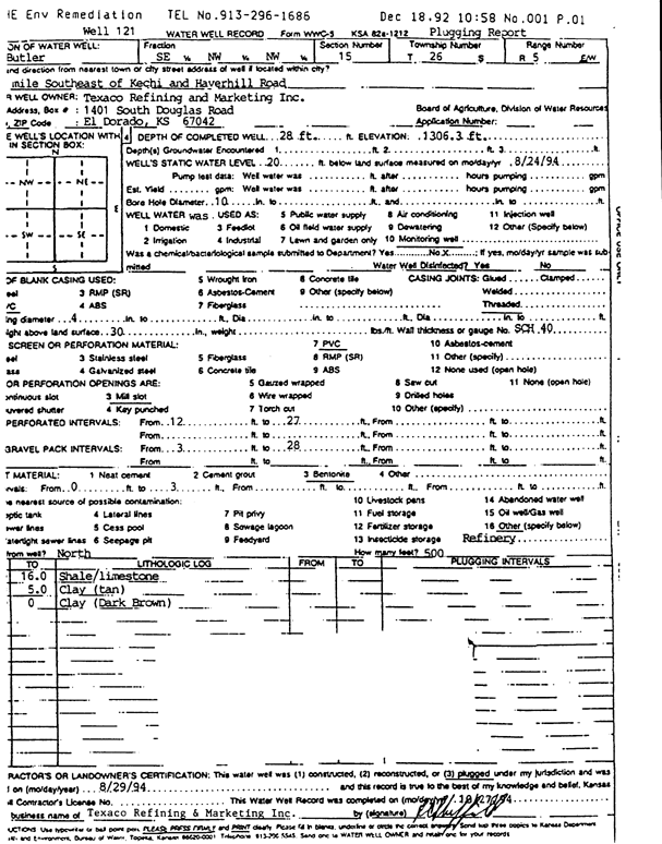
T26S, R5E, Sec. 15 SE NW NW |
Texaco Refining and Marketing, Inc. | 28 ft. | 20 ft. | Monitoring well/observation/piezometer | Well 121 | Plugged | 29-Aug-1994 | Scan | |
|
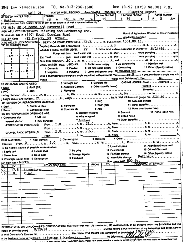
T26S, R5E, Sec. 15 SE NW NW |
Texaco Refining and Marketing, Inc. | 79.2 ft. | 22 ft. | Monitoring well/observation/piezometer | Well 21 | Plugged | 29-Aug-1994 | Scan | |
|
T26S, R5E, Sec. 16 NE NE NE NE |
Tri-Hydro | 15.5 ft. | 9 ft. | Monitoring well/observation/piezometer | Constructed | 27-Feb-2009 | |||
|
T26S, R5E, Sec. 17 E2 SE SE |
Shell Oil Products | 9 ft. | 2.5 ft. | Monitoring well/observation/piezometer | MW 4 | Constructed | 10-Sep-2007 | ||
|
T26S, R5E, Sec. 17 NE SE SE |
Shell Oil Products | 7 ft. | 2.5 ft. | Monitoring well/observation/piezometer | MW 8 | Constructed | 01-Feb-2008 | ||
|
T26S, R5E, Sec. 17 NE SE SE |
Shell Oil Products | 6.5 ft. | 2.85 ft. | Monitoring well/observation/piezometer | MW 10 | Constructed | 01-Feb-2008 | ||
|
T26S, R5E, Sec. 17 E2 SE SE |
Shell Oil Products | 7 ft. | 2.75 ft. | Monitoring well/observation/piezometer | MW 6 | Constructed | 10-Sep-2007 | ||
|
T26S, R5E, Sec. 17 E2 SE SE |
Shell Oil Products | 7.5 ft. | 2.75 ft. | Monitoring well/observation/piezometer | MW 5 | Constructed | 10-Sep-2007 | ||
|
T26S, R5E, Sec. 17 NE NE SE SE |
Shell Oil Products | 8 ft. | Monitoring well/observation/piezometer | Constructed | 12-Mar-2009 | ||||
|
T26S, R5E, Sec. 17 SE SE SE |
Shell Oil Products | 8.5 ft. | 2.95 ft. | Monitoring well/observation/piezometer | MW 9 | Constructed | 01-Feb-2008 | ||
|
T26S, R5E, Sec. 17 SE SE SE |
Shell Oil Products | 6 ft. | 2.75 ft. | Monitoring well/observation/piezometer | MW 7 | Constructed | 01-Feb-2008 | ||
|
T26S, R5E, Sec. 17 SE SE NE |
Shell Oil Products US | 10 ft. | 3.92 ft. | Monitoring well/observation/piezometer | MW 1 | Constructed | 18-Apr-2006 | ||
|
T26S, R5E, Sec. 17 SE SE NE |
Shell Oil Products US | 9 ft. | 5.4 ft. | Monitoring well/observation/piezometer | MW 2 | Constructed | 19-Apr-2006 | ||
|
T26S, R5E, Sec. 17 SE SE NE |
Shell Oil Products US | 10 ft. | Monitoring well/observation/piezometer | MW 3 | Constructed | 19-Apr-2006 | |||
|
T26S, R5E, Sec. 18 NE SW SE SE |
Pullen, Andy | 97 ft. | 24 ft. | 40 gpm. | Domestic, Lawn and Garden | Constructed | 07-Aug-2019 |
KOLAR |
|
|
T26S, R5E, Sec. 19 SE NE NW |
Vestering, Bob | 125 ft. | 40 ft. | 20 gpm. | Domestic, Lawn and Garden | Constructed | 16-Nov-2012 | ||
|
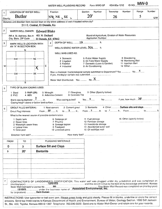
T26S, R5E, Sec. 20 NW NE SE |
Blake, Edward | 19 ft. | Monitoring well/observation/piezometer | MW 9 | Plugged | 01-Dec-2003 | Scan | ||
|
T26S, R5E, Sec. 21 SW SW |
Butler County Landfill | 20 ft. | 8.1 ft. | Monitoring well/observation/piezometer | PZ 9 | Constructed | 18-Aug-2004 | ||
|
T26S, R5E, Sec. 21 SW SW |
Butler County Landfill | 16 ft. | 5.7 ft. | Monitoring well/observation/piezometer | PZ 7 | Constructed | 18-Aug-2004 | ||
|
T26S, R5E, Sec. 21 SW SW |
Butler County Landfill | 20 ft. | 10.8 ft. | Monitoring well/observation/piezometer | PZ 8 | Constructed | 18-Aug-2004 | ||
|
T26S, R5E, Sec. 21 SW SW |
Butler County Landfill | 18.5 ft. | 11.6 ft. | Monitoring well/observation/piezometer | PZ 6 | Constructed | 18-Aug-2004 | ||
| View page: < Prev || 51 || 52 || 53 || 54 || 55 || 56 || 57 || 58 || 59 || 60 || Next > | |||||||||