Select location of well to view details.
Click on column heading to sort.
|
|
|
County: Rawlins Select location of well to view details. Click on column heading to sort. |
|
|
|
| View page: 1 || 2 || 3 || 4 || 5 || 6 || 7 || 8 || 9 || 10 || Next > | |||||||||
| T-R-S | Owner | Well Depth Ascend. Desc. |
Static Water Level Ascend. Desc. |
Est. Yield Ascend. Desc. |
Well Use | Other ID | Action Taken | Completion Date Ascend. Desc. |
Scan? |
|
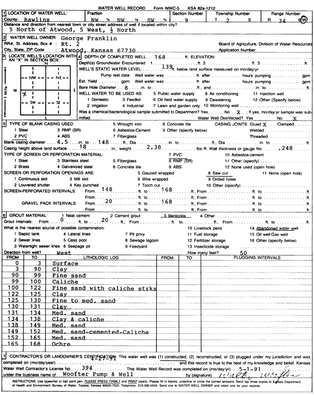
T2S, R34W, Sec. 9 NW NW SW |
Franklin, George | 168 ft. | 139 ft. | Domestic | Constructed | 27-Apr-1991 | Scan | ||
|
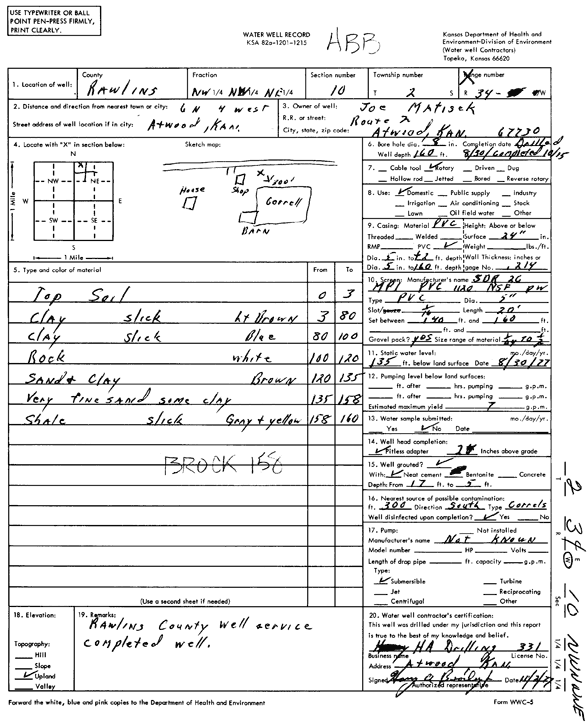
T2S, R34W, Sec. 10 NW NW NE |
Matisek, Joe | 160 ft. | 135 ft. | 7 gpm. | Domestic | Constructed | 30-Aug-1977 | Scan | |
|
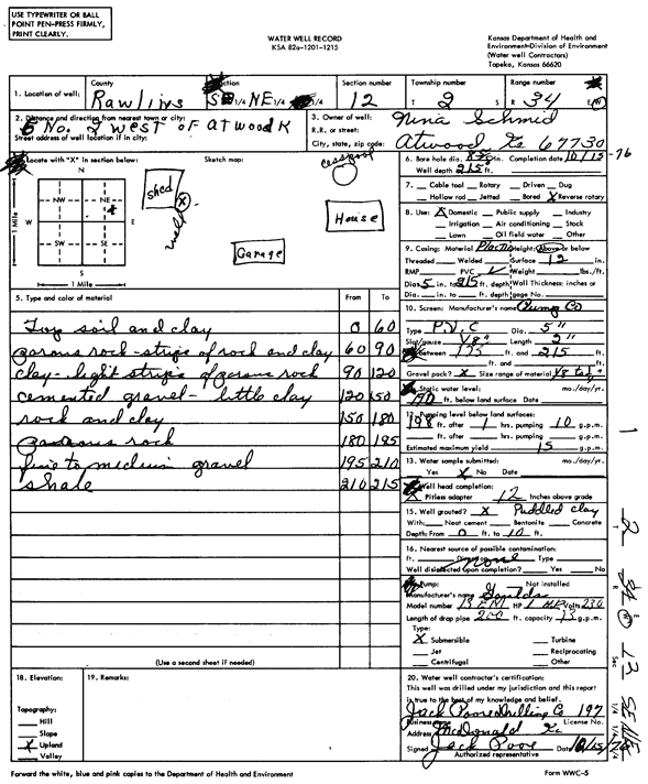
T2S, R34W, Sec. 12 SE NE |
Schmid, Nina | 215 ft. | 190 ft. | 15 gpm. | Domestic | Constructed | 15-Oct-1976 | Scan | |
|
T2S, R34W, Sec. 16 SE SE SE SW |
Castle Resources | 185 ft. | 161 ft. | 10 gpm. | Oil Field Water Supply | Warley 1 | Constructed | 01-Jan-2018 | |
|
T2S, R34W, Sec. 16 SE SE SE SW |
Castle Resources | 181 ft. | 161 ft. | 10 gpm. | Oil Field Water Supply | Warley 1 | Constructed | 01-Jan-2018 | |
|
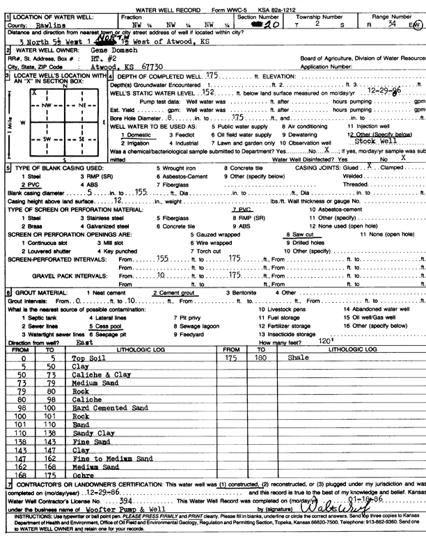
T2S, R34W, Sec. 20 NW NW NW |
Domsch, Gene | 175 ft. | 152 ft. | Domestic, Livestock | Constructed | 29-Dec-1986 | Scan | ||
|
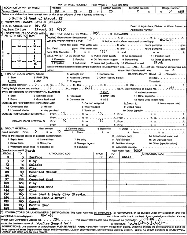
T2S, R34W, Sec. 20 NW SE SE |
Heussman, Gerald | 185 ft. | 126 ft. | Domestic | Constructed | 01-Oct-1986 | Scan | ||
|
T2S, R34W, Sec. 21 SE NE NW NW |
Crouse, Sam | 160 ft. | 100 ft. | 25 gpm. | Domestic, Livestock | Constructed | 22-May-2014 |
KOLAR |
|
|
T2S, R34W, Sec. 22 SW NW SW NW |
Murfin Drilling Co. | 182 ft. | 160 ft. | Oil Field Water Supply | Focke Unit 1-22 | Plugged | 07-Nov-2017 |
KOLAR |
|
|
T2S, R34W, Sec. 22 SW NW SW NW |
Murfin Drilling Co. | 182 ft. | 160 ft. | 8 gpm. | Oil Field Water Supply | Focke Unit 1-22 | Constructed | 15-May-2017 |
KOLAR |
|
T2S, R34W, Sec. 24 NE NE SW |
Loeffler, Chris | 177 ft. | Domestic | Constructed | 12-Mar-2015 | ||||
|
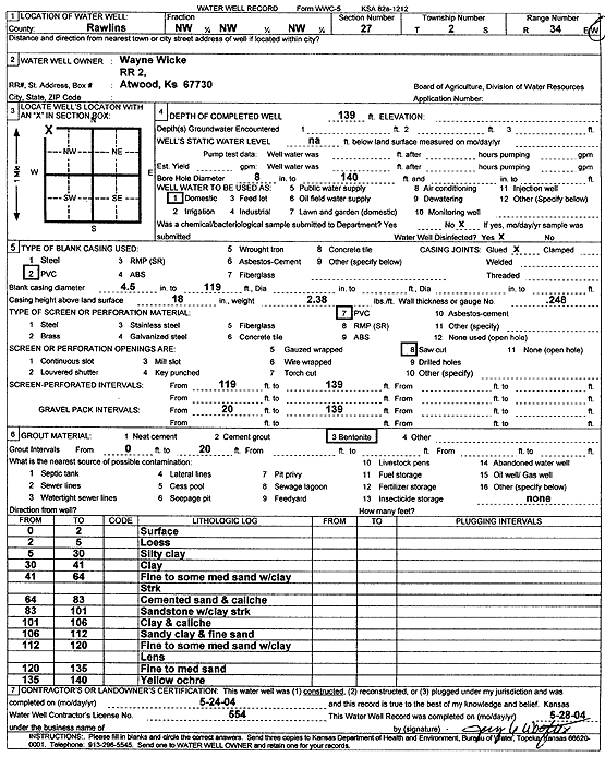
T2S, R34W, Sec. 27 NW NW NW |
Wicke, Wayne | 139 ft. | Domestic | Constructed | 24-May-2004 | Scan | |||
|
T2S, R34W, Sec. 29 NW NW SE |
Crouse, Sam | 37 ft. | 15 ft. | 25 gpm. | Domestic, Livestock | Constructed | 23-Apr-2026 |
KOLAR |
|
|
T2S, R34W, Sec. 29 SE SE SW |
Crouse, Sam | 35 ft. | 24 ft. | Domestic | Constructed | 19-Aug-2004 | |||
|
T2S, R34W, Sec. 32 SE NE SW SE |
Ziegler, James | 80 ft. | 30 ft. | 15 gpm. | Domestic, Livestock | Constructed | 29-Jul-2013 |
KOLAR |
|
|
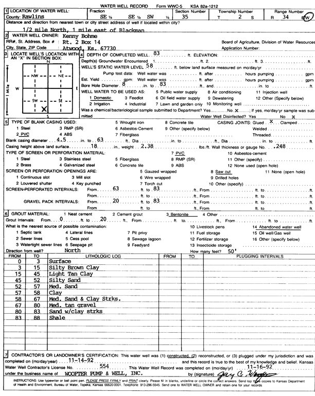
T2S, R34W, Sec. 35 SE SE SW |
Bohme, Kenny | 83 ft. | 58 ft. | Domestic | Constructed | 14-Nov-1992 | Scan | ||
|
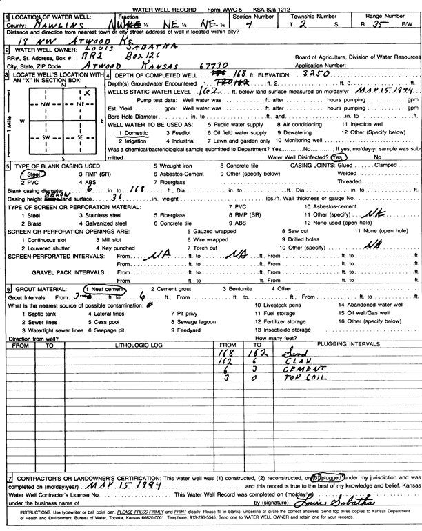
T2S, R35W, Sec. 4 NW NE NE |
Sabatha, Louis | 168 ft. | 162 ft. | Domestic | Plugged | 15-May-1994 | Scan | ||
|
T2S, R35W, Sec. 8 NW NW NW NW |
Eugene Jones | 225 ft. | 160 ft. | Oil Field Water Supply | Plugged | 26-Mar-2018 |
KOLAR |
||
|
T2S, R35W, Sec. 8 NW NW NW |
Jones, Eugene | 225 ft. | Oil Field Water Supply | Constructed | 18-Feb-2008 | ||||
|
T2S, R35W, Sec. 13 NW SW NW NE |
Kopriva Farms, Inc. | 210 ft. | 169 ft. | 75 gpm. | Irrigation | Well 4 | Constructed | 20-Apr-2017 |
KOLAR |
|
T2S, R35W, Sec. 13 SW NE SE SW |
Kopriva Farms, Inc. | 210 ft. | 152 ft. | 100 gpm. | Irrigation | Constructed | 19-Apr-2017 |
KOLAR |
|
|
T2S, R35W, Sec. 13 SE NE NE NW |
Kopriva Farms, Inc. | 210 ft. | 168 ft. | 75 gpm. | Irrigation | Constructed | 24-Apr-2017 |
KOLAR |
|
|
T2S, R35W, Sec. 13 NW NE SE SW |
Kopriva Farms, Inc. | 210 ft. | 154 ft. | 75 gpm. | Irrigation | Constructed | 18-Apr-2017 |
KOLAR |
|
|
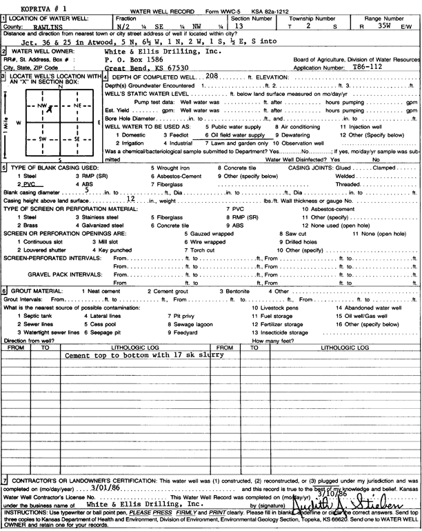
T2S, R35W, Sec. 13 N2 SE NW |
White and Ellis Drilling, Inc. | 208 ft. | Oil Field Water Supply | Kopriva 1 | Plugged | 01-Mar-1986 | Scan | ||
|
T2S, R35W, Sec. 14 NW NE SE NW |
Murfin Drilling Co. | 210 ft. | 145 ft. | 50 gpm. | Oil Field Water Supply | Kopriva 1-14 | Constructed | 05-Jun-2017 |
KOLAR |
|
T2S, R35W, Sec. 15 SW SW SW |
Frisbie, Dave | 195 ft. | 130 ft. | 20 gpm. | Domestic, Livestock | Constructed | 18-Aug-2009 | ||
|
T2S, R35W, Sec. 15 SW SW SW |
Frisbie, Dave | 195 ft. | 130 ft. | 20 gpm. | Domestic, Livestock | Constructed | 18-Apr-2010 | ||
|
T2S, R35W, Sec. 17 SW SW SW NW |
Frisbie, David | 243 ft. | 171 ft. | 250 gpm. | Irrigation | Constructed | 01-Feb-2012 | ||
|
T2S, R35W, Sec. 17 SW SW SW NW |
Frisbie, David | 245 ft. | 171 ft. | 250 gpm. | Irrigation | Constructed | 10-Jan-2012 | ||
|
T2S, R35W, Sec. 17 SW SW SW NW |
Frisbie, David | 250 ft. | 171 ft. | 250 gpm. | Irrigation | Constructed | 15-Jan-2012 | ||
|
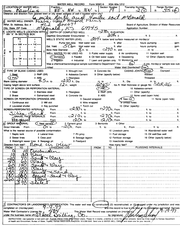
T2S, R35W, Sec. 19 NE NW NW |
Frisbie Farms | 270 ft. | 204 ft. | 50 gpm. | Domestic | Constructed | 09-Sep-1997 | Scan | |
|
T2S, R35W, Sec. 19 NW NW NE NW |
Frisbie Wheat | 275 ft. | 170 ft. | 50 gpm. | Domestic | Constructed | 25-Apr-2011 | ||
|
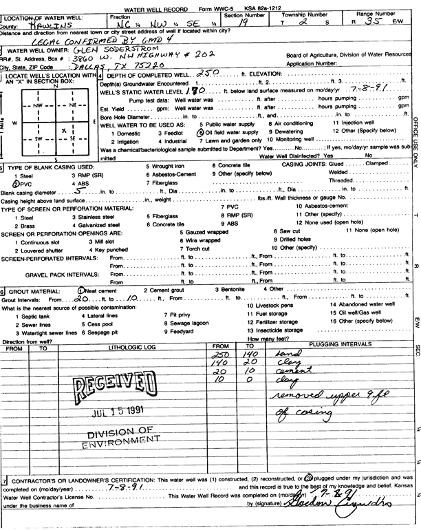
T2S, R35W, Sec. 19 C NW SE |
Soderstrom, Glen | 250 ft. | 170 ft. | Oil Field Water Supply | Plugged | 08-Jul-1991 | Scan | ||
|
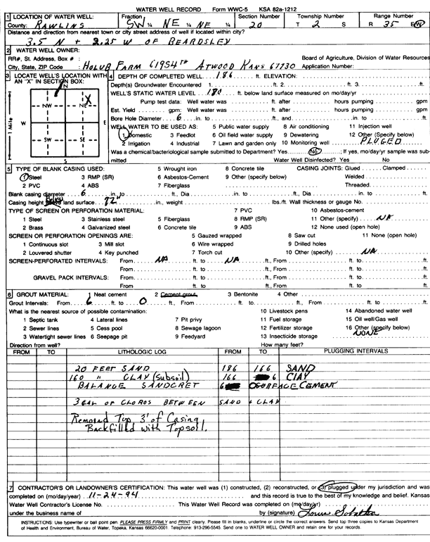
T2S, R35W, Sec. 20 SW NE NE |
Holub Farm | 186 ft. | 180 ft. | Domestic | Plugged | 24-Nov-1994 | Scan | ||
|
T2S, R35W, Sec. 20 NW SE NE SE |
Uhlgender, Ted and Karen | 272 ft. | 167 ft. | 10 gpm. | Domestic, Livestock | Constructed | 07-Aug-2008 | ||
|
T2S, R35W, Sec. 21 SE SW SW SW |
City of Atwood | 282 ft. | 171 ft. | Test hole/well | test well | Plugged | 11-Nov-2010 | ||
|
T2S, R35W, Sec. 21 NE SW SE SW |
City of Atwood | 285 ft. | Test hole/well | Constructed | 21-Sep-2009 | ||||
|
T2S, R35W, Sec. 21 SW SE SE SW |
City of Atwood | 297 ft. | 174 ft. | 375 gpm. | Public Water Supply | well 8 | Constructed | 13-Sep-2010 | |
|
T2S, R35W, Sec. 21 SW SW NE SW |
City of Atwood | 277 ft. | 176 ft. | Irrigation | Plugged | 11-Nov-2010 | |||
|
T2S, R35W, Sec. 23 NE SE SW SE |
Five Pochop LLC | 127 ft. | 41 ft. | 12 gpm. | Domestic, Livestock | Constructed | 25-Aug-2021 |
KOLAR |
|
|
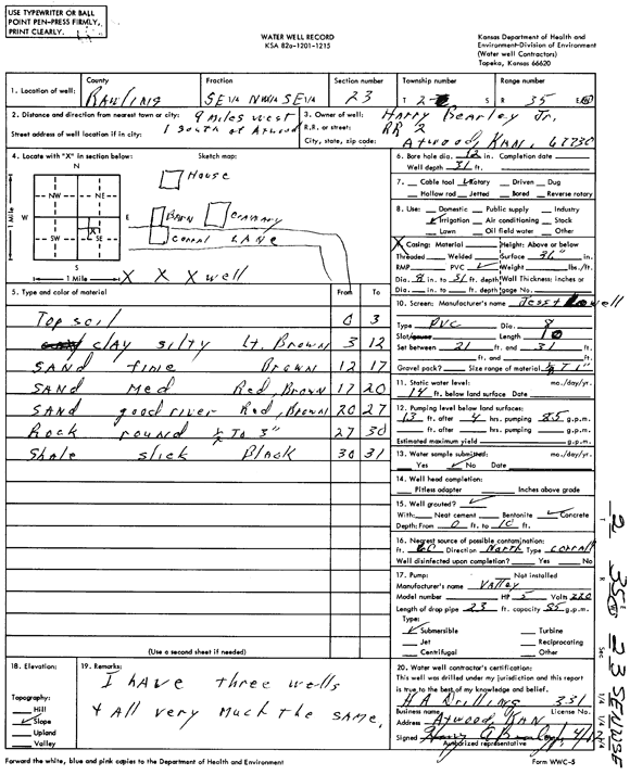
T2S, R35W, Sec. 23 SE NW SE |
Harry Bearley, Jr. | 31 ft. | 14 ft. | Irrigation | Constructed | 12-Apr-1977 | Scan | ||
|
T2S, R35W, Sec. 26 NW NW NE NW |
Pochop, Gerard | 195 ft. | 117 ft. | 12 gpm. | Domestic, Livestock | Constructed | 17-Feb-2020 |
KOLAR |
|
|
T2S, R35W, Sec. 26 SW SE SE |
Ralph and Vince Pochop Trust | 61 ft. | 26 ft. | Domestic, Livestock | Constructed | 16-Oct-2007 | |||
|
T2S, R35W, Sec. 26 N2 NE SE NE |
Wederski, Leon | 125 ft. | Domestic | Constructed | 26-Mar-2010 | ||||
|
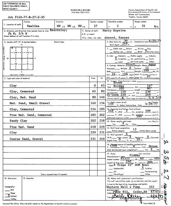
T2S, R35W, Sec. 27 NW NW NW |
Kopriva, Marty | 249 ft. | 150 ft. | 599 gpm. | Irrigation | Constructed | 25-Apr-1977 | Scan | |
|
T2S, R35W, Sec. 27 NW NE SE SW |
Victor, Pochop | 206 ft. | 109 ft. | 10 gpm. | Domestic, Livestock | Constructed | 10-Apr-2023 | ||
|
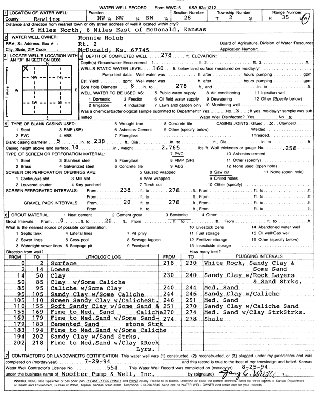
T2S, R35W, Sec. 28 NW NW NW |
Holub, Ronnie | 278 ft. | 160 ft. | Domestic | Constructed | 29-Jul-1994 | Scan | ||
|
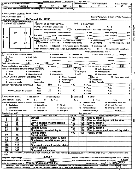
T2S, R35W, Sec. 28 SE SE NE |
Orten, Don | 190 ft. | 82 ft. | Domestic | Constructed | 20-May-2002 | Scan | ||
|
T2S, R35W, Sec. 29 SE SE SW NE |
Uhlaender, Karen (was Murfin Drilling) | 265 ft. | 180 ft. | 50 gpm. | Domestic, changed from Oil Field Water Supply | Uhlaender 1-29 | Constructed | 14-Aug-2017 |
KOLAR |
|
T2S, R35W, Sec. 32 NE NE NE NE |
City of Atwood | 251 ft. | 132 ft. | 150 gpm. | Public Water Supply | well 7 | Constructed | 09-Sep-2010 | |
| View page: 1 || 2 || 3 || 4 || 5 || 6 || 7 || 8 || 9 || 10 || Next > | |||||||||