Select location of well to view details.
Click on column heading to sort.
|
|
|
County: Rush Select location of well to view details. Click on column heading to sort. |
|
|
|
| View page: < Prev || 11 || 12 || 13 || 14 || 15 || 16 || 17 || 18 || 19 || 20 || Next > | |||||||||
| T-R-S | Owner | Well Depth Ascend. Desc. |
Static Water Level Ascend. Desc. |
Est. Yield Ascend. Desc. |
Well Use | Other ID | Action Taken | Completion Date Ascend. Desc. |
Scan? |
|
T17S, R19W, Sec. 1 SE SE SE |
Schneider, Mary | 275 ft. | 160 ft. | Domestic | Constructed | 10-May-1984 | |||
|
T17S, R19W, Sec. 2 SE NE SE |
Burton, Randy | 280 ft. | 176 ft. | 10 gpm. | Domestic, Livestock | Constructed | 05-Feb-2025 |
KOLAR |
|
|
T17S, R19W, Sec. 5 SE SW SW |
Olkers, Shelly | 450 ft. | 166 ft. | Domestic, Livestock | Constructed | 03-Jul-2025 |
KOLAR |
||
|
T17S, R19W, Sec. 6 SE SW SE |
Herman, Blake | 420 ft. | 145 ft. | Domestic, Livestock | Constructed | 30-Dec-2024 |
KOLAR |
||
|
T17S, R19W, Sec. 9 SE SE NE |
Weber, Harold | 417 ft. | 150 ft. | Domestic, Livestock | Constructed | 15-Aug-1983 | |||
|
T17S, R19W, Sec. 10 SW SW SW |
Schwindt Farms | 425 ft. | 211 ft. | Domestic, Livestock | Constructed | 11-Oct-2023 |
KOLAR |
||
|
T17S, R19W, Sec. 11 SW NE SW |
Schwindt Farms | 405 ft. | 138 ft. | Domestic, Livestock | Constructed | 11-Oct-2023 |
KOLAR |
||
|
T17S, R19W, Sec. 11 SE SE SE |
Schwindt Farms | 415 ft. | 120 ft. | Domestic, Livestock | Constructed | 11-Oct-2023 |
KOLAR |
||
|
T17S, R19W, Sec. 12 SE SE SE |
Littler, Eugene | Domestic | Plugged | 16-Apr-1998 | |||||
|
T17S, R19W, Sec. 12 SE SE NW |
Littler, Eugene | 305 ft. | Domestic | Plugged | 19-Apr-1998 | ||||
|
T17S, R19W, Sec. 12 NE SW SW SW |
Schulte Farms, LLC | 380 ft. | 176 ft. | 15 gpm. | Domestic, Livestock | Constructed | 22-Oct-2019 |
KOLAR |
|
|
T17S, R19W, Sec. 13 NW NW NW |
Huber, Julie | 405 ft. | 81 ft. | Domestic, Livestock | Constructed | 27-Dec-2024 |
KOLAR |
||
|
T17S, R19W, Sec. 15 SW SW NE SE |
Brack, John | 460 ft. | 144 ft. | 60 gpm. | Domestic, Livestock | Constructed | 28-Dec-2017 | ||
|
T17S, R19W, Sec. 15 SE SE NW |
Wilson, Bruce | 350 ft. | 160 ft. | Domestic | Plugged | 30-Aug-2006 | |||
|
T17S, R19W, Sec. 15 NE NE NE |
Wilson, Bruce | 450 ft. | 270 ft. | Domestic | Constructed | 29-Apr-2006 | |||
|
T17S, R19W, Sec. 16 NE NE NE |
Schroter, Bill | 457 ft. | 256 ft. | 6 gpm. | Domestic | Constructed | 26-Apr-2013 | ||
|
T17S, R19W, Sec. 20 NW SW SE |
Farmers Union Coop | 16 ft. | 6.09 ft. | Monitoring well/observation/piezometer | MW 1 | Constructed | 11-Jul-1995 | ||
|
T17S, R19W, Sec. 20 NW SW SE |
Farmers Union Coop | 40 ft. | 31.18 ft. | Monitoring well/observation/piezometer | MW 8 | Constructed | 25-Jul-1995 | ||
|
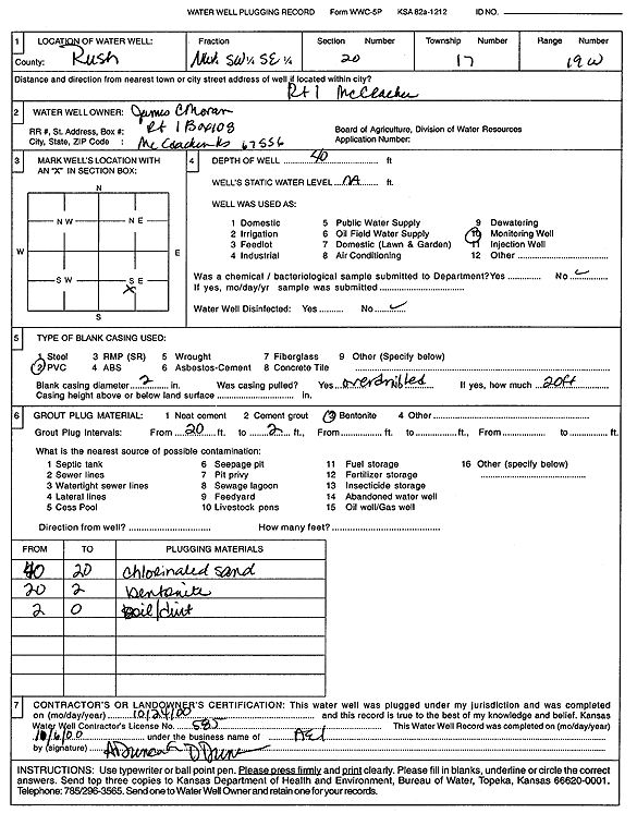
T17S, R19W, Sec. 20 NE SW SE |
Moran, James | 48.05 ft. | 20.6 ft. | Monitoring well/observation/piezometer | MW 3 | Plugged | 12-Sep-2023 |
KOLAR |
|
|
T17S, R19W, Sec. 20 NE SW SE |
Moran, James | 35.55 ft. | 18 ft. | Monitoring well/observation/piezometer | MW 7 | Plugged | 12-Sep-2023 |
KOLAR |
|
|
T17S, R19W, Sec. 20 NE SW SE |
Moran, James | 44 ft. | 19.86 ft. | Monitoring well/observation/piezometer | MW 2 | Plugged | 12-Dec-2022 |
KOLAR |
|
|
T17S, R19W, Sec. 20 NW SW SE |
Moran, James C | 40 ft. | 6.95 ft. | Monitoring well/observation/piezometer | MW 5 | Constructed | 19-Jul-1995 | ||
|
T17S, R19W, Sec. 20 NW SW SE |
Moran, James C | 44.5 ft. | 28.02 ft. | Monitoring well/observation/piezometer | MW 2 | Constructed | 19-Jul-1995 | ||
|
T17S, R19W, Sec. 20 NW SW SE |
Moran, James C | 40 ft. | 23.02 ft. | Monitoring well/observation/piezometer | MW 6 | Constructed | 20-Jul-1995 | ||
|
T17S, R19W, Sec. 20 NW SW SE |
Moran, James C | 49 ft. | 26.51 ft. | Monitoring well/observation/piezometer | MW 3 | Constructed | 19-Jul-1995 | ||
|
T17S, R19W, Sec. 20 NW SW SE |
Moran, James C | 40 ft. | 37.78 ft. | Monitoring well/observation/piezometer | MW 10 | Constructed | 25-Jul-1995 | ||
|
T17S, R19W, Sec. 20 NW SW SE |
Moran, James C | 40 ft. | 24.44 ft. | Monitoring well/observation/piezometer | MW 9 | Constructed | 24-Jul-1995 | ||
|
T17S, R19W, Sec. 20 NW SW SE |
Moran, James C | 40 ft. | 24.16 ft. | Monitoring well/observation/piezometer | MW 7 | Constructed | 24-Jul-1995 | ||
|
T17S, R19W, Sec. 20 NW SW SE |
Moran, James C | 40 ft. | 27.65 ft. | Monitoring well/observation/piezometer | MW 4 | Constructed | 19-Jul-1995 | ||
|
T17S, R19W, Sec. 20 NW SW SE |
Moran, James C. | 40 ft. | Monitoring well/observation/piezometer | Plugged | 24-Oct-2000 | Scan | |||
|
T17S, R19W, Sec. 20 NW NE SW SE |
Moran, Paul | 40 ft. | 26.29 ft. | Monitoring well/observation/piezometer | MW 13 | Constructed | 05-Mar-2018 | ||
|
T17S, R19W, Sec. 20 NE SW SE |
Moran, Paul | 40 ft. | 13.1 ft. | Monitoring well/observation/piezometer | MW 14 | Plugged | 12-Sep-2023 |
KOLAR |
|
|
T17S, R19W, Sec. 20 NE SW SE |
Moran, Paul | 40.05 ft. | 14.15 ft. | Monitoring well/observation/piezometer | MW 13 | Plugged | 12-Sep-2023 |
KOLAR |
|
|
T17S, R19W, Sec. 20 NW NE SW SE |
Moran, Paul | 40 ft. | 26.73 ft. | Monitoring well/observation/piezometer | MW 14 | Constructed | 27-Nov-2018 | ||
|
T17S, R19W, Sec. 20 NW SW SE |
Westhusin, Vance | 45 ft. | 38.4 ft. | Monitoring well/observation/piezometer | MW 11 | Constructed | 08-Apr-2009 | ||
|
T17S, R19W, Sec. 20 NW SW SE |
Westhusin, Vance | 45 ft. | 36.29 ft. | Monitoring well/observation/piezometer | MW 12 | Constructed | 08-Apr-2009 | ||
|
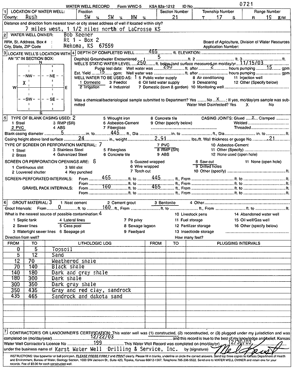
T17S, R19W, Sec. 21 SW SW NW |
Keener, Bob | 465 ft. | 250 ft. | 15 gpm. | Domestic | Constructed | 22-Dec-2003 | Scan | |
|
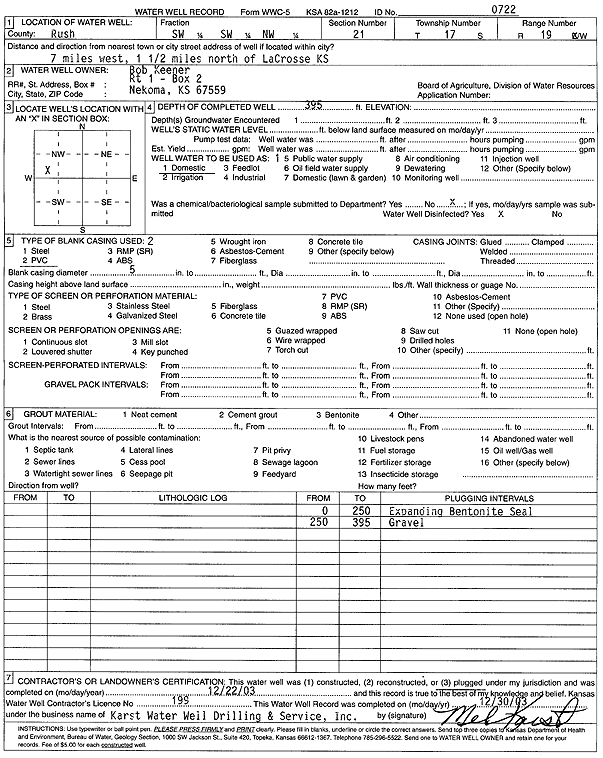
T17S, R19W, Sec. 21 SW SW NW |
Keener, Bob | 395 ft. | Domestic | Plugged | 22-Dec-2003 | Scan | |||
|
T17S, R19W, Sec. 21 SE SE SE |
Keener, Bob | 480 ft. | 256 ft. | 15 gpm. | Domestic | Constructed | 23-Jul-2013 | ||
|
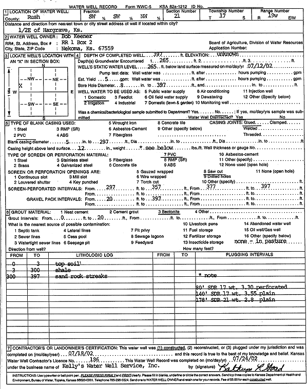
T17S, R19W, Sec. 21 SW SW NW |
Keener, Bob | 397 ft. | 265 ft. | 5 gpm. | Domestic | Constructed | 18-Jul-2002 | Scan | |
|
T17S, R19W, Sec. 21 NW NE NE |
Olkers, Shelly | 500 ft. | 255 ft. | 10 gpm. | Domestic, Livestock | Constructed | 02-Jul-2025 |
KOLAR |
|
|
T17S, R19W, Sec. 23 SW NW NW |
Werth, Harland | 395 ft. | 159 ft. | Domestic, Livestock | Constructed | 19-Oct-2023 |
KOLAR |
||
|
T17S, R19W, Sec. 24 SE SW SE |
Wet Walnut Watershed | 431 ft. | 185 ft. | Domestic, Livestock | Constructed | 19-Apr-1983 | |||
|
T17S, R19W, Sec. 25 NE NE NW |
Burton, Randy | 380 ft. | 198 ft. | 30 gpm. | Domestic, Livestock | Constructed | 30-Apr-2026 |
KOLAR |
|
|
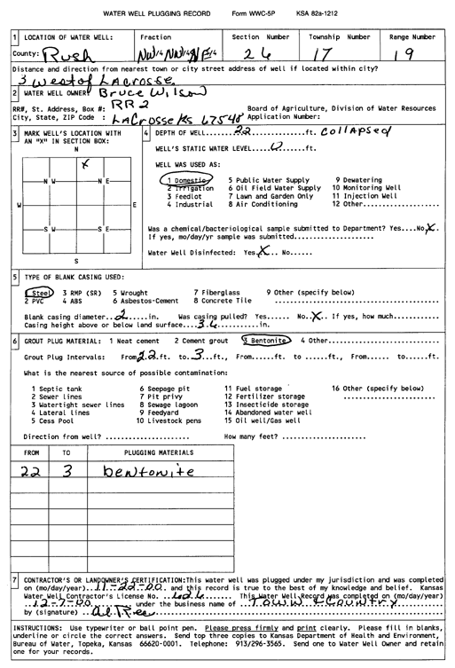
T17S, R19W, Sec. 26 NW NW NE |
Wilson, Bruce | 22 ft. | Domestic | Plugged | 22-Nov-2000 | Scan | |||
|
T17S, R19W, Sec. 28 NE NE SW |
Albers, E B | 450 ft. | 180 ft. | 15 gpm. | Domestic | Constructed | 07-Jan-1981 | ||
|
T17S, R20W, Sec. 1 NE SE SE |
Baldwin, Richard | 45 ft. | 20 ft. | 10 gpm. | Domestic | Constructed | 23-Jun-2005 | ||
|
T17S, R20W, Sec. 2 SE SW SW |
Rogers, Les | 40 ft. | 24 ft. | Domestic | Constructed | 11-Dec-1981 | |||
|
T17S, R20W, Sec. 2 W2 E2 SW SW |
Rogers, Leslie | 457 ft. | 265 ft. | 18 gpm. | Domestic | Constructed | 02-Apr-2014 |
KOLAR |
|
|
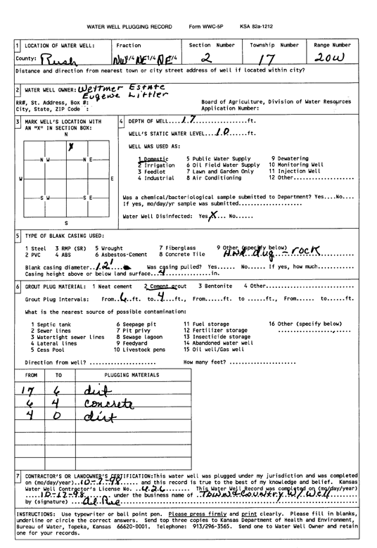
T17S, R20W, Sec. 2 NW NE NE |
Weytmer Estate | 17 ft. | 10 ft. | Domestic | Plugged | 17-Oct-1998 | Scan | ||
| View page: < Prev || 11 || 12 || 13 || 14 || 15 || 16 || 17 || 18 || 19 || 20 || Next > | |||||||||