Select location of well to view details.
Click on column heading to sort.
|
|
|
County: Rush Select location of well to view details. Click on column heading to sort. |
|
|
|
| View page: < Prev || 21 || 22 || 23 || 24 || 25 || 26 || 27 || 28 || 29 || 30 || Next > | |||||||||
| T-R-S | Owner | Well Depth Ascend. Desc. |
Static Water Level Ascend. Desc. |
Est. Yield Ascend. Desc. |
Well Use | Other ID | Action Taken | Completion Date Ascend. Desc. |
Scan? |
|
T18S, R20W, Sec. 20 SE SW SE |
Farmer's Co-Op Oil and Supply Co | 39 ft. | 31.1 ft. | Monitoring well/observation/piezometer | MW 4 | Constructed | 27-Jan-1993 | ||
|
T18S, R20W, Sec. 20 SE SW SE |
Farmer's Co-Op Oil and Supply Co | 39.5 ft. | 30.12 ft. | Monitoring well/observation/piezometer | MW 3 | Constructed | 27-Jan-1993 | ||
|
T18S, R20W, Sec. 20 SE SW SE |
Farmer's Co-Op Oil and Supply Co | 25 ft. | Environmental Remediation, Soil Vapor Extraction | VE 7 | Constructed | 03-Mar-1995 | |||
|
T18S, R20W, Sec. 20 SE SW SE |
Farmer's Co-Op Oil and Supply Co | 40 ft. | 30 ft. | Monitoring well/observation/piezometer | MW 14 | Constructed | 12-Mar-1994 | ||
|
T18S, R20W, Sec. 20 SE SW SE |
Farmers Coop Oil and Supply Co | 44.17 ft. | 27.1 ft. | Environmental Remediation, Air Sparge | AS 9 | Plugged | 16-Jul-2021 | ||
|
T18S, R20W, Sec. 20 SE SW SE |
Farmers Coop Oil and Supply Co | 44.28 ft. | 27.41 ft. | Environmental Remediation, Air Sparge | AS 8 | Plugged | 16-Jul-2021 | ||
|
T18S, R20W, Sec. 20 SE SW SE |
Farmers Coop Oil and Supply Co | 44.6 ft. | 27.79 ft. | Environmental Remediation, Air Sparge | AS 7 | Plugged | 16-Jul-2021 | ||
|
T18S, R20W, Sec. 20 SE SW SE |
Farmers Coop Oil and Supply Co | 43.8 ft. | 27.8 ft. | Environmental Remediation, Air Sparge | AS 6 | Plugged | 16-Jul-2021 | ||
|
T18S, R20W, Sec. 20 SE SW SE |
Farmers Coop Oil and Supply Co | 33.23 ft. | 28.06 ft. | Environmental Remediation, Soil Vapor Extraction | SVE 4 | Plugged | 16-Jul-2021 | ||
|
T18S, R20W, Sec. 20 SE SW SE |
Farmers Coop Oil and Supply Co | 45.12 ft. | 27.83 ft. | Environmental Remediation, Air Sparge | AS 5 | Plugged | 16-Jul-2021 | ||
|
T18S, R20W, Sec. 20 SE SW SE |
Farmers Coop Oil and Supply Co | 33.88 ft. | 28.14 ft. | Environmental Remediation, Soil Vapor Extraction | SVE 2 | Plugged | 16-Jul-2021 | ||
|
T18S, R20W, Sec. 20 SE SW SE |
Farmers Coop Oil and Supply Co | 29.88 ft. | 27.42 ft. | Environmental Remediation, Soil Vapor Extraction | SVE 1 | Plugged | 16-Jul-2021 | ||
|
T18S, R20W, Sec. 20 SE SW SE |
Farmers Coop Oil and Supply Co | 33.19 ft. | 27.59 ft. | Environmental Remediation, Soil Vapor Extraction | SVE 5 | Plugged | 16-Jul-2021 | ||
|
T18S, R20W, Sec. 20 SE SW SE |
Farmers Coop Oil and Supply Co | 45.41 ft. | 28.18 ft. | Environmental Remediation, Air Sparge | AS 3 | Plugged | 16-Jul-2021 | ||
|
T18S, R20W, Sec. 20 SE SW SE |
Farmers Coop Oil and Supply Co | 34.13 ft. | 28.04 ft. | Environmental Remediation, Soil Vapor Extraction | SVE 3 | Plugged | 16-Jul-2021 | ||
|
T18S, R20W, Sec. 20 NE SW SW |
Mid-State Farmers Coop | 34 ft. | Environmental Remediation, Soil Vapor Extraction | SVE 3 | Constructed | 27-May-2011 | |||
|
T18S, R20W, Sec. 20 NE SW SW |
Mid-State Farmers Coop | 34 ft. | Environmental Remediation, Soil Vapor Extraction | SVE 6 | Constructed | 23-May-2011 | |||
|
T18S, R20W, Sec. 20 NE SW SW |
Mid-State Farmers Coop | 44.5 ft. | Environmental Remediation, Air Sparge | AS 7 | Constructed | 25-May-2011 | |||
|
T18S, R20W, Sec. 20 NE SW SW |
Mid-State Farmers Coop | 34 ft. | Environmental Remediation, Soil Vapor Extraction | SVE 4 | Constructed | 27-May-2011 | |||
|
T18S, R20W, Sec. 20 NE SW SW |
Mid-State Farmers Coop | 44.5 ft. | Environmental Remediation, Air Sparge | AS 10 | Constructed | 26-May-2011 | |||
|
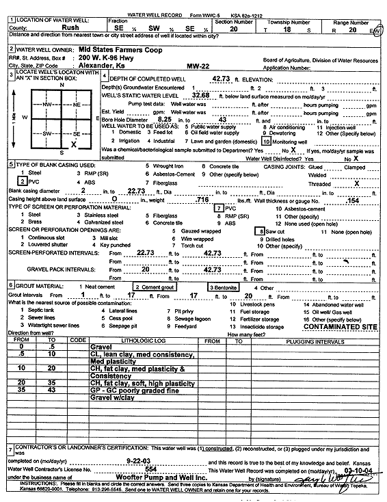
T18S, R20W, Sec. 20 SE SW SE |
Mid-State Farmers Coop | 42.73 ft. | 32.68 ft. | Monitoring well/observation/piezometer | MW 22 | Constructed | 22-Sep-2003 | Scan | |
|
T18S, R20W, Sec. 20 NE SW SW SE |
Mid-State Farmers Coop | 42.5 ft. | Environmental Remediation, Air Sparge | AS 1 | Constructed | 25-Jun-2009 | |||
|
T18S, R20W, Sec. 20 NE SW SW SE |
Mid-State Farmers Coop | 34 ft. | 27.57 ft. | Monitoring well/observation/piezometer | MW 11 | Constructed | 24-Jun-2009 | ||
|
T18S, R20W, Sec. 20 NE SW SW SE |
Mid-State Farmers Coop | 47 ft. | 28.25 ft. | Monitoring well/observation/piezometer | MW 12 D | Constructed | 23-Jun-2009 | ||
|
T18S, R20W, Sec. 20 SW SW SE |
Mid-State Farmers Coop | 35 ft. | 28.63 ft. | Monitoring well/observation/piezometer | MW 8 | Constructed | 21-Jan-2009 | ||
|
T18S, R20W, Sec. 20 NE SW SW SE |
Mid-State Farmers Coop | 46 ft. | 27.55 ft. | Monitoring well/observation/piezometer | MW 11 D | Constructed | 01-Jul-2009 | ||
|
T18S, R20W, Sec. 20 SW SW SE |
Mid-State Farmers Coop | 35 ft. | 29.09 ft. | Monitoring well/observation/piezometer | MW 4 | Constructed | 21-Jan-2009 | ||
|
T18S, R20W, Sec. 20 SW SW SE |
Mid-State Farmers Coop | 35 ft. | 28.65 ft. | Monitoring well/observation/piezometer | MW 1 | Constructed | 20-Jan-2009 | ||
|
T18S, R20W, Sec. 20 SW SW SE |
Mid-State Farmers Coop | 35 ft. | 29.21 ft. | Monitoring well/observation/piezometer | MW 7 | Constructed | 20-Jan-2009 | ||
|
T18S, R20W, Sec. 20 NE SW SW SE |
Mid-State Farmers Coop | 42.5 ft. | Monitoring well/observation/piezometer | ASOBW 1 | Constructed | 26-Jun-2009 | |||
|
T18S, R20W, Sec. 20 NE SW SW SE |
Mid-State Farmers Coop | 35 ft. | 28.15 ft. | Monitoring well/observation/piezometer | MW 12 | Constructed | 23-Jun-2009 | ||
|
T18S, R20W, Sec. 20 NE SW SW SE |
Mid-State Farmers Coop | 47 ft. | 27.77 ft. | Monitoring well/observation/piezometer | MW 10 D | Constructed | 01-Jul-2009 | ||
|
T18S, R20W, Sec. 20 NE SW SW SE |
Mid-State Farmers Coop | 34 ft. | Monitoring well/observation/piezometer | VOB 1 | Constructed | 24-Jun-2009 | |||
|
T18S, R20W, Sec. 20 NE SW SW SE |
Mid-State Farmers Coop | 34 ft. | Environmental Remediation, Soil Vapor Extraction | SVE 1 | Constructed | 25-Jun-2009 | |||
|
T18S, R20W, Sec. 20 SW SW SE |
Mid-State Farmers Coop | 35 ft. | 28.9 ft. | Monitoring well/observation/piezometer | MW 2 | Constructed | 20-Jan-2009 | ||
|
T18S, R20W, Sec. 20 SW SW SE |
Mid-State Farmers Coop | 35 ft. | 29.04 ft. | Monitoring well/observation/piezometer | MW 5 | Constructed | 22-Jan-2009 | ||
|
T18S, R20W, Sec. 20 NE SW SW SE |
Mid-State Farmers Coop | 34 ft. | 28.87 ft. | Monitoring well/observation/piezometer | MW 10 | Constructed | 01-Jul-2009 | ||
|
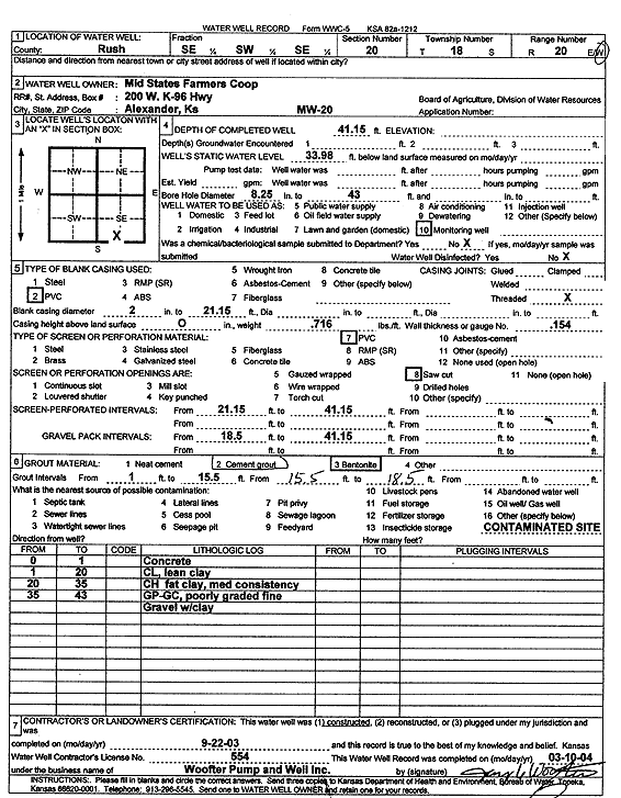
T18S, R20W, Sec. 20 SE SW SE |
Mid-State Farmers Coop | 41.15 ft. | 33.98 ft. | Monitoring well/observation/piezometer | MW 20 | Constructed | 22-Sep-2003 | Scan | |
|
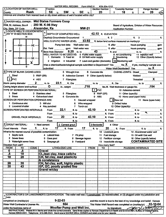
T18S, R20W, Sec. 20 SE SW SE |
Mid-State Farmers Coop | 42.1 ft. | 33.92 ft. | Monitoring well/observation/piezometer | MW 21 | Constructed | 22-Sep-2003 | Scan | |
|
T18S, R20W, Sec. 20 SW SW SE |
Mid-State Farmers Coop | 35 ft. | 29.08 ft. | Monitoring well/observation/piezometer | MW 3 | Constructed | 20-Jan-2009 | ||
|
T18S, R20W, Sec. 20 SW SW SE |
Mid-State Farmers Coop | 35 ft. | 28.97 ft. | Monitoring well/observation/piezometer | MW 6 | Constructed | 21-Jan-2009 | ||
|
T18S, R20W, Sec. 20 SW SW SE |
Mid-State Farmers Coop | 35 ft. | 28.94 ft. | Monitoring well/observation/piezometer | MW 9 | Constructed | 22-Jan-2009 | ||
|
T18S, R20W, Sec. 20 NW SW SW SE |
Mid-State Farmers Coop | 42.35 ft. | 28.71 ft. | Monitoring well/observation/piezometer | MW 13 | Plugged | 28-Jun-2017 | ||
|
T18S, R20W, Sec. 20 NE SW SW SE |
Mid-State Farmers Coop | 34.44 ft. | 28.7 ft. | Monitoring well/observation/piezometer | MW 9 | Plugged | 28-Jun-2017 | ||
|
T18S, R20W, Sec. 20 NE SW SW SE |
Mid-State Farmers Coop | 44.2 ft. | 28.52 ft. | Environmental Remediation, Air Sparge | AS 9 | Plugged | 28-Jun-2017 | ||
|
T18S, R20W, Sec. 20 NE SW SW SE |
Mid-State Farmers Coop | 44.4 ft. | 28.59 ft. | Environmental Remediation, Air Sparge | AS 3 | Plugged | 28-Jun-2017 | ||
|
T18S, R20W, Sec. 20 NW SW SW SE |
Mid-State Farmers Coop | 44.35 ft. | 28.55 ft. | Environmental Remediation, Air Sparge | AS 8 | Plugged | 28-Jun-2017 | ||
|
T18S, R20W, Sec. 20 SE NW SW SE |
Mid-State Farmers Coop | 34.91 ft. | 27.46 ft. | Monitoring well/observation/piezometer | MW 12 | Plugged | 28-Jun-2017 | ||
|
T18S, R20W, Sec. 20 NW SW SW SE |
Mid-State Farmers Coop | 41.85 ft. | 28.4 ft. | Environmental Remediation, Air Sparge | AS 1 | Plugged | 28-Jun-2017 | ||
|
T18S, R20W, Sec. 20 NW SW SW SE |
Mid-State Farmers Coop | 44.35 ft. | 28.47 ft. | Environmental Remediation, Air Sparge | AS 2 | Plugged | 28-Jun-2017 | ||
| View page: < Prev || 21 || 22 || 23 || 24 || 25 || 26 || 27 || 28 || 29 || 30 || Next > | |||||||||