Select location of well to view details.
Click on column heading to sort.
|
|
|
County: Russell Select location of well to view details. Click on column heading to sort. |
|
|
|
| View page: < Prev || 21 || 22 || 23 || 24 || 25 || 26 || 27 || 28 || 29 || 30 || Next > | |||||||||
| T-R-S | Owner | Well Depth Ascend. Desc. |
Static Water Level Ascend. Desc. |
Est. Yield Ascend. Desc. |
Well Use | Other ID | Action Taken | Completion Date Ascend. Desc. |
Scan? |
|
T14S, R11W, Sec. 7 NE SE NW |
Vondrocek, Steven | 62 ft. | 45 ft. | 15 gpm. | Domestic, Lawn and Garden | Constructed | 29-Jun-1995 | ||
|
T14S, R11W, Sec. 8 SE NE NW |
Gress, Michael E. | 120 ft. | 79 ft. | Domestic, Livestock | Constructed | 18-Aug-2025 |
KOLAR |
||
|
T14S, R11W, Sec. 9 SE NE NE |
Homeier, Ralph | 264 ft. | 210 ft. | 10 gpm. | Domestic | Constructed | 25-Jul-2012 | ||
|
T14S, R11W, Sec. 9 SE SE SE |
Johnson, Jon and Michele | 230 ft. | 179 ft. | 13 gpm. | Domestic | Constructed | 29-Oct-1996 | ||
|
T14S, R11W, Sec. 9 NE NW NW |
Reilly, L.S. | 35 ft. | 18 ft. | 5 gpm. | Domestic, Livestock | Constructed | 12-Sep-1994 | ||
|
T14S, R11W, Sec. 10 NE SE SE |
Soukup, Jerry | 180 ft. | 150 ft. | 12 gpm. | Domestic, Livestock | Constructed | 03-Apr-2024 |
KOLAR |
|
|
T14S, R11W, Sec. 11 SE NW NW |
Pasek, Larry | 277 ft. | 170 ft. | 20 gpm. | Domestic, Livestock | Constructed | 29-Apr-2013 | ||
|
T14S, R11W, Sec. 11 NE NW NE |
Soukup, Leonard | 290 ft. | 238 ft. | 20 gpm. | Domestic, Livestock | Constructed | 06-Nov-2024 |
KOLAR |
|
|
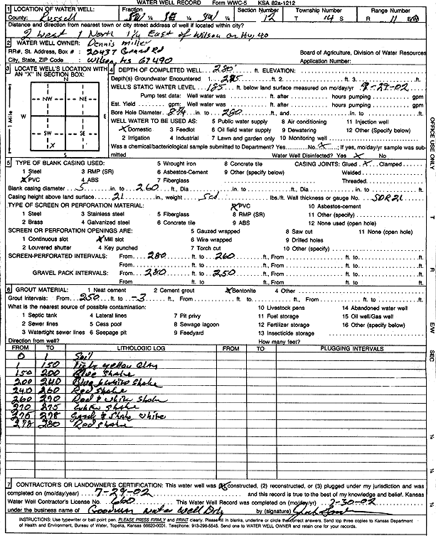
T14S, R11W, Sec. 12 SW SE SW |
Miller, Dennis | 280 ft. | 185 ft. | Domestic | Constructed | 29-Jul-2002 | Scan | ||
|
T14S, R11W, Sec. 15 NW SE SE |
Hutchinson, Jay | 60 ft. | 38 ft. | 20 gpm. | Domestic | Constructed | 28-Dec-1984 | ||
|
T14S, R11W, Sec. 15 NW SE SE |
Lloyd, Tom | 60 ft. | 36 ft. | 20 gpm. | Domestic, Lawn and Garden | Constructed | 23-Aug-2013 | ||
|
T14S, R11W, Sec. 15 SW SW SW |
Major, Steven | 37 ft. | 32 ft. | 8 gpm. | Public Water Supply | Constructed | 04-Jul-1986 | ||
|
T14S, R11W, Sec. 19 NE SW NW SW |
Herber, Gary | 200 ft. | Geothermal, Closed Loop, Vertical | Constructed | 12-Feb-2015 | ||||
|
T14S, R11W, Sec. 19 NE SW NW SW |
Herber, Gary | 148 ft. | 82 ft. | 25 gpm. | Domestic, Lawn and Garden | Constructed | 12-Feb-2015 | ||
|
T14S, R11W, Sec. 20 SW SE SE |
Hatzenbuehler, Dean | 242 ft. | 185 ft. | 12 gpm. | Domestic | Constructed | 26-Oct-2011 | ||
|
T14S, R11W, Sec. 20 NE NW NW |
Holt, Gordon | 50 ft. | 30 ft. | 10 gpm. | Domestic | Constructed | 22-Jan-1996 | ||
|
T14S, R11W, Sec. 20 SW SW SE |
Whitmer, Richard | 45 ft. | 22 ft. | 20 gpm. | Domestic | Constructed | 15-Mar-2010 | ||
|
T14S, R11W, Sec. 20 SW SW SE |
Whitmer, Richard | 104 ft. | Domestic | Plugged | 15-Mar-2010 | ||||
|
T14S, R11W, Sec. 20 SW SW SE |
Whitmer, Richard | 17 ft. | 15 ft. | Domestic | Plugged | 15-Mar-2010 | |||
|
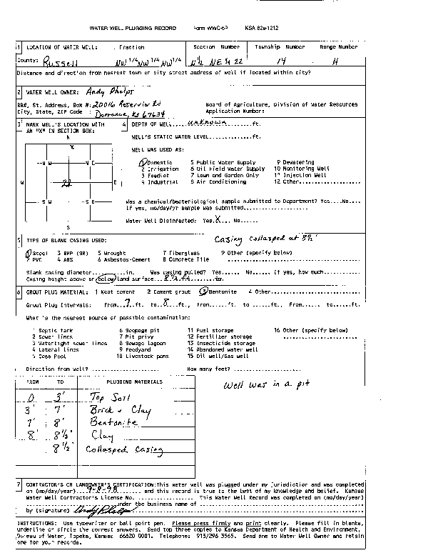
T14S, R11W, Sec. 22 NW NE NE |
Phelps, Andy | 33.9 ft. | 24 ft. | Domestic | Plugged | 08-Sep-1998 | |||
|
T14S, R11W, Sec. 22 NW NE NE |
Phelps, Andy | 50 ft. | 25 ft. | 12 gpm. | Domestic | Constructed | 02-Dec-1998 | ||
|
T14S, R11W, Sec. 22 NW NW NE |
Phelps, Andy | Domestic | Plugged | 08-Sep-1998 | Scan | ||||
|
T14S, R11W, Sec. 24 NE NW NW |
Sebesta, Duane | 38 ft. | 32 ft. | Domestic | Plugged | 12-Apr-2002 | Scan | ||
|
T14S, R11W, Sec. 24 NW NW SW |
Sebesta, Ernest | 137 ft. | 117 ft. | 17 gpm. | Domestic | Constructed | 29-Jun-1986 | ||
|
T14S, R11W, Sec. 26 NW SE SW |
Lamatsch, Vernon | 65 ft. | 40 ft. | Domestic | Constructed | 11-Apr-2002 | Scan | ||
|
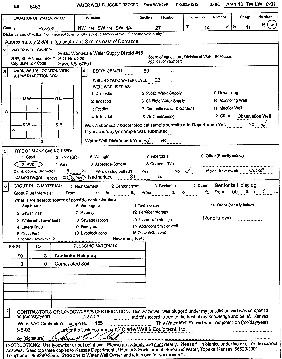
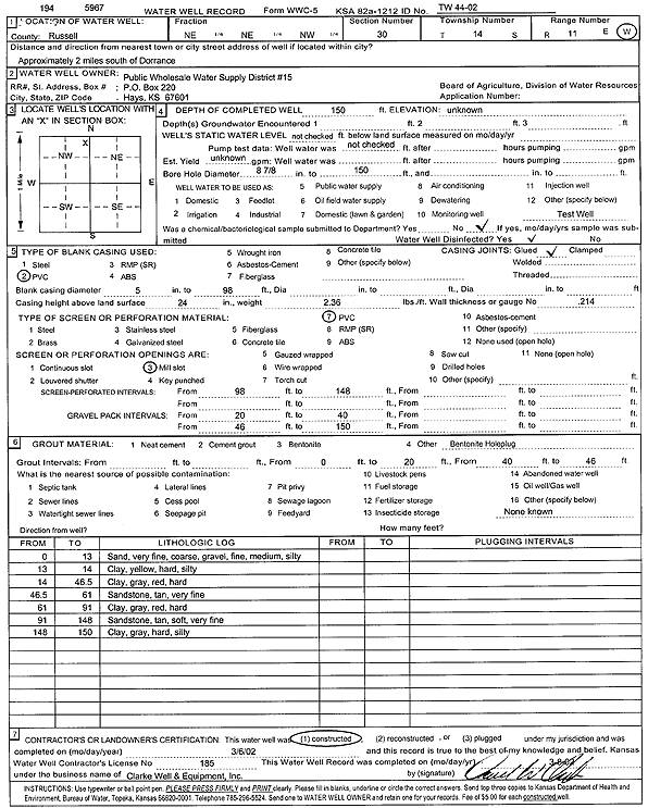
T14S, R11W, Sec. 27 NW SW SW |
Public Wholesale Water Supply District 15 | 59 ft. | 26 ft. | Monitoring well/observation/piezometer | Area 10, TW LW 10-01 | Plugged | 27-Feb-2003 | Scan | |
|
T14S, R11W, Sec. 27 NE NE NE |
Steinle, Henry T. | 48 ft. | 33 ft. | 60 gpm. | Domestic | Constructed | 10-Feb-1984 | ||
|
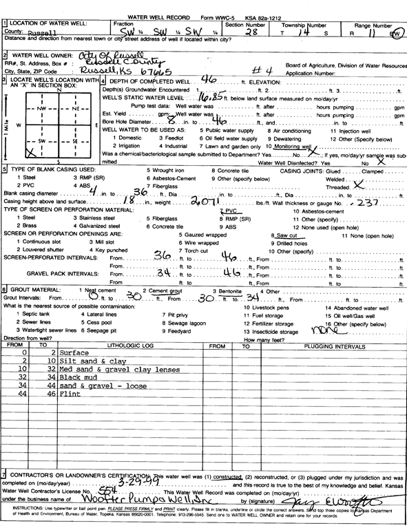
T14S, R11W, Sec. 28 SW SW SW |
City of Russell | 46 ft. | 16.85 ft. | Monitoring well/observation/piezometer | 4 | Constructed | 29-Mar-1999 | Scan | |
|
T14S, R11W, Sec. 28 SW SW SW |
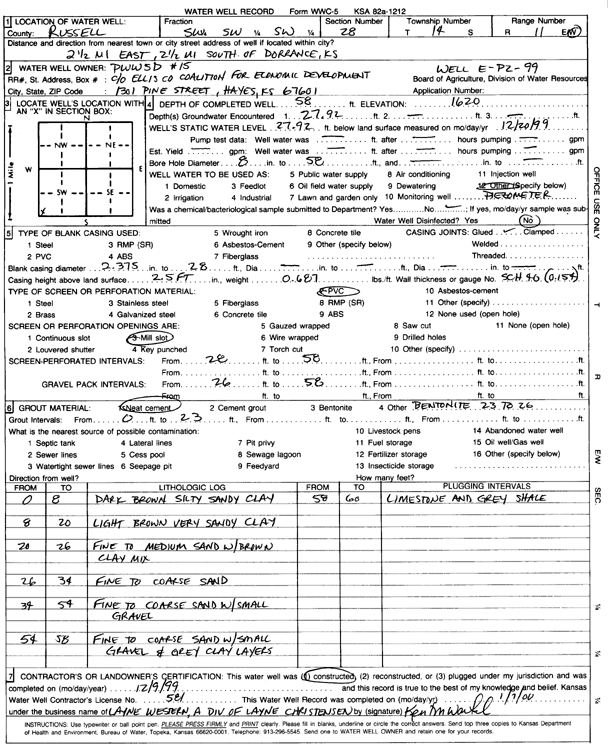
Public Wholesale Water Supply District 15 | 58 ft. | 27.92 ft. | Monitoring well/observation/piezometer | E P2 99 | Constructed | 09-Dec-1999 | Scan | |
|
T14S, R11W, Sec. 28 SW SW SW |
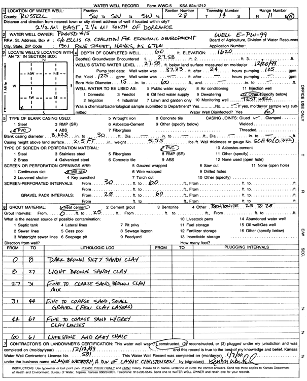
Public Wholesale Water Supply District 15 | 60 ft. | 27.58 ft. | 125 gpm. | Test hole/well | E PW 99 | Constructed | 14-Dec-1999 | Scan |
|
T14S, R11W, Sec. 29 SW NE SE |
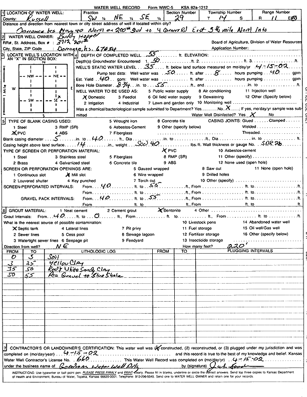
Hopper, Buddy | 55 ft. | 35 ft. | 40 gpm. | Domestic | Constructed | 15-Apr-2002 | Scan | |
|
T14S, R11W, Sec. 29 SW NE SE |
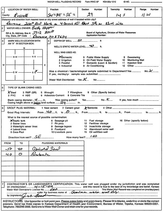
Hopper, Buddy | 50 ft. | 40 ft. | Domestic | Plugged | 15-Apr-2002 | Scan | ||
|
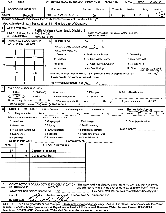
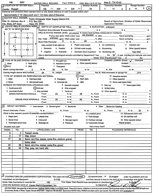
T14S, R11W, Sec. 29 NE NW SW |
Public Wholesale Water Supply District 15 | 57 ft. | 19 ft. | Monitoring well/observation/piezometer | Area 9, TW 45-02 | Plugged | 27-Feb-2003 | Scan | |
|
T14S, R11W, Sec. 29 NE NW SW |
Public Wholesale Water Supply District 15 | 60 ft. | Test hole/well | Area 9, TW 45-02 | Constructed | 07-Mar-2002 | Scan | ||
|
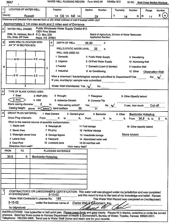
T14S, R11W, Sec. 29 C2 NE |
Public Wholesale Water Supply District 15 | 36.9 ft. | 26 ft. | Monitoring well/observation/piezometer | E Cross Section Montoya | Plugged | 13-May-2002 | Scan | |
|
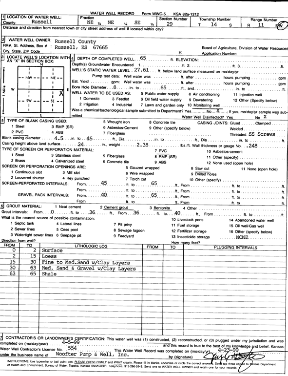
T14S, R11W, Sec. 29 NE NE SE |
Russell County | 65 ft. | 27.61 ft. | Monitoring well/observation/piezometer | E | Constructed | 05-Apr-1999 | Scan | |
|
T14S, R11W, Sec. 30 SW SE NE |
Heinze, Lloyd | 38 ft. | 8 ft. | Domestic | Plugged | 21-Aug-2001 | Scan | ||
|
T14S, R11W, Sec. 30 NE NE NE |
Heinze, Lloyd | 27 ft. | 17 ft. | Domestic | Plugged | 21-Aug-2001 | Scan | ||
|
T14S, R11W, Sec. 30 NE NE NW |
Public Wholesale Water Supply District 15 | 150 ft. | Test hole/well | TW 44-02 | Constructed | 06-Mar-2002 | Scan | ||
|
T14S, R11W, Sec. 31 NE SE SE |
Allen Drilling Co. | 46 ft. | 16 ft. | 50 gpm. | Oil Field Water Supply | Constructed | 07-Jul-1978 | ||
|
T14S, R11W, Sec. 31 NE NE SE |
Habiger, Wayne | 35 ft. | 16 ft. | 8 gpm. | Domestic | Constructed | 28-Oct-2005 | ||
|
T14S, R11W, Sec. 31 NW NW SE |
Sander, Cody | 50 ft. | 18 gpm. | Domestic, Livestock | Constructed | 21-Aug-2015 | |||
|
T14S, R11W, Sec. 32 NW SE NW |
Sander, Cody | 210 ft. | 140 ft. | 15 gpm. | Domestic, Livestock | Constructed | 08-Aug-2012 | ||
|
T14S, R12W, Sec. 1 NW NW NW |
Galliart, Dale | 320 ft. | 225 ft. | 10 gpm. | Domestic | Constructed | 29-Aug-2012 | ||
|
T14S, R12W, Sec. 1 SE SE SE |
Galliart, Dale | 315 ft. | 130 ft. | 15 gpm. | Domestic | Constructed | 13-Nov-2010 | ||
|
T14S, R12W, Sec. 1 SW SE SW |
Steinlo, Scott | 230 ft. | Domestic | Constructed | 20-Oct-2002 | Scan | |||
|
T14S, R12W, Sec. 2 NE NE NE |
Galliart, Reuben | 267 ft. | 242 ft. | 5 gpm. | Domestic | Constructed | 26-Feb-1986 | ||
|
T14S, R12W, Sec. 3 SE NW NW |
Mahoney, Kenneth | 276 ft. | 210 ft. | Domestic | Constructed | 28-Jun-2006 | |||
|
T14S, R12W, Sec. 5 SE SE SW |
Ross, Jerry | 335 ft. | 190 ft. | 20 gpm. | Domestic | Constructed | 20-Oct-1995 | ||
|
T14S, R12W, Sec. 6 SW SW SW |
Michigan Reutilization LLC | 28.1 ft. | 17.72 ft. | Monitoring well/observation/piezometer | MW 2 | Constructed | 12-Jul-2007 | ||
| View page: < Prev || 21 || 22 || 23 || 24 || 25 || 26 || 27 || 28 || 29 || 30 || Next > | |||||||||