Select location of well to view details.
Click on column heading to sort.
|
|
|
County: Russell Select location of well to view details. Click on column heading to sort. |
|
|
|
| View page: < Prev || 21 || 22 || 23 || 24 || 25 || 26 || 27 || 28 || 29 || 30 || Next > | |||||||||
| T-R-S | Owner | Well Depth Ascend. Desc. |
Static Water Level Ascend. Desc. |
Est. Yield Ascend. Desc. |
Well Use | Other ID | Action Taken | Completion Date Ascend. Desc. |
Scan? |
|
T14S, R14W, Sec. 2 NE SW SW NW |
Dunn, Angela | 27.87 ft. | 18.36 ft. | Monitoring well/observation/piezometer | MW 20 | Plugged | 06-Feb-2019 | ||
|
T14S, R14W, Sec. 2 SW NW SW NW |
Dunn, Angela | 28.94 ft. | 14.05 ft. | Monitoring well/observation/piezometer | MW 19 | Plugged | 06-Feb-2019 | ||
|
T14S, R14W, Sec. 2 NW SW NW |
Dunn, Angela | 23.1 ft. | 15.52 ft. | Monitoring well/observation/piezometer | MW 1 | Plugged | 06-Feb-2019 | ||
|
T14S, R14W, Sec. 2 NW SW NW |
Dunn, Angela | 27 ft. | 15.65 ft. | Monitoring well/observation/piezometer | MW 2 | Plugged | 06-Feb-2019 | ||
|
T14S, R14W, Sec. 2 NW SW NW |
Dunn, Angela | 24.55 ft. | 14.9 ft. | Monitoring well/observation/piezometer | MW 4 | Plugged | 06-Feb-2019 | ||
|
T14S, R14W, Sec. 2 NW SW NW |
Dunn, Angela | 24.38 ft. | 18.52 ft. | Monitoring well/observation/piezometer | MW 6 | Plugged | 06-Feb-2019 | ||
|
T14S, R14W, Sec. 2 NW SW NW |
Dunn, Angela | 28.7 ft. | 17.5 ft. | Monitoring well/observation/piezometer | MW 7 | Plugged | 06-Feb-2019 | ||
|
T14S, R14W, Sec. 2 NW SW NW |
Dunn, Angela | 26.28 ft. | 14.8 ft. | Monitoring well/observation/piezometer | MW 9 | Plugged | 06-Feb-2019 | ||
|
T14S, R14W, Sec. 2 NW SW NW |
Dunn, Angela | 33.79 ft. | 16.58 ft. | Monitoring well/observation/piezometer | MW 10 R | Plugged | 06-Feb-2019 | ||
|
T14S, R14W, Sec. 2 NW SW NW |
Dunn, Angela | 29.7 ft. | 16.46 ft. | Monitoring well/observation/piezometer | MW 15 | Plugged | 06-Feb-2019 | ||
|
T14S, R14W, Sec. 2 SW SW NW |
Dunn, Angela | 35.21 ft. | 18.06 ft. | Monitoring well/observation/piezometer | MW 17 R | Plugged | 06-Feb-2019 | ||
|
T14S, R14W, Sec. 2 SW NW SW NW |
Dunn, Angela | 28.74 ft. | 13.6 ft. | Monitoring well/observation/piezometer | MW 18 | Plugged | 06-Feb-2019 | ||
|
T14S, R14W, Sec. 2 SW NW SW NW |
Dunn, Angela | 28.94 ft. | 14.05 ft. | Monitoring well/observation/piezometer | MW 19 | Plugged | 06-Feb-2019 | ||
|
T14S, R14W, Sec. 2 SW SW SW |
Gage, Chas A | 25 ft. | 10 ft. | 40 gpm. | Domestic | Constructed | 29-Dec-1977 | ||
|
T14S, R14W, Sec. 2 NE SW SW NW |
KDHE | 35.2 ft. | 21.9 ft. | Monitoring well/observation/piezometer | MW-17R | Constructed | 11-May-2015 |
KOLAR |
|
|
T14S, R14W, Sec. 2 SW NW SW NW |
KDHE | 35 ft. | 19.55 ft. | Monitoring well/observation/piezometer | MW 10R | Constructed | 11-May-2015 |
KOLAR |
|
|
T14S, R14W, Sec. 2 NW SW NW |
Pasek, Rick | 33 ft. | 15 ft. | 5 gpm. | Domestic, Lawn and Garden | Constructed | 25-Oct-2014 | ||
|
T14S, R14W, Sec. 2 NW NW NW |
Pasek, Rick | 100 ft. | Domestic, Lawn and Garden | Plugged | 17-Apr-2014 | ||||
|
T14S, R14W, Sec. 2 NW SW NW |
Phillips 66 Co. | 24.3 ft. | Monitoring well/observation/piezometer | MW 5 | Plugged | 14-May-2008 | |||
|
T14S, R14W, Sec. 2 NW SW NW |
Phillips 66 Co. | 24.1 ft. | Monitoring well/observation/piezometer | MW 4 | Plugged | 14-May-2008 | |||
|
T14S, R14W, Sec. 2 NW SW NW |
Phillips 66 Co. | 24.3 ft. | Monitoring well/observation/piezometer | MW 6 | Plugged | 14-May-2008 | |||
|
T14S, R14W, Sec. 2 NW SW NW |
Phillips 66 Co. | 28.3 ft. | Monitoring well/observation/piezometer | MW 1 R | Plugged | 14-May-2008 | |||
|
T14S, R14W, Sec. 2 NW SW NW |
Phillips 66 Co. | 24 ft. | Monitoring well/observation/piezometer | MW 11 | Plugged | 14-May-2008 | |||
|
T14S, R14W, Sec. 2 NW SW NW |
Phillips 66 Co. | 21.4 ft. | Monitoring well/observation/piezometer | MW 2 | Plugged | 14-May-2008 | |||
|
T14S, R14W, Sec. 2 NW SW NW |
Phillips 66 Co. | 24.13 ft. | Monitoring well/observation/piezometer | MW 3 | Plugged | 14-May-2008 | |||
|
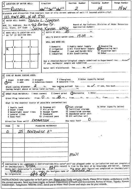
T14S, R14W, Sec. 2 NW SW NW |
Sampson, Darwin L | 25 ft. | 17.09 ft. | Monitoring well/observation/piezometer | MW 1 | Plugged | 17-Sep-2002 | Scan | |
|
T14S, R14W, Sec. 2 NW SW NW |
Sampson, Darwin L | 25 ft. | 16.15 ft. | Monitoring well/observation/piezometer | MW 5 | Constructed | 28-Jun-1994 | ||
|
T14S, R14W, Sec. 2 NW SW NW |
Sampson, Darwin L | 25 ft. | 15.68 ft. | Monitoring well/observation/piezometer | MW 11 | Constructed | 29-Jun-1994 | ||
|
T14S, R14W, Sec. 2 NW SW NW |
Sampson, Darwin L | 25 ft. | 16.6 ft. | Monitoring well/observation/piezometer | MW 2 | Constructed | 27-Jun-1994 | ||
|
T14S, R14W, Sec. 2 NW SW NW |
Sampson, Darwin L | 25 ft. | 17.04 ft. | Monitoring well/observation/piezometer | MW 4 | Constructed | 27-Jun-1994 | ||
|
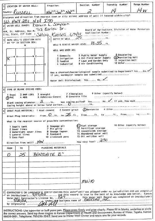
T14S, R14W, Sec. 2 NW SW NW |
Sampson, Darwin L | 25 ft. | 18.35 ft. | Monitoring well/observation/piezometer | MW 10 | Constructed | 28-Jun-1994 | ||
|
T14S, R14W, Sec. 2 NW SW NW |
Sampson, Darwin L | 25 ft. | 17.31 ft. | Monitoring well/observation/piezometer | MW 8 | Constructed | 28-Jun-1994 | ||
|
T14S, R14W, Sec. 2 NW SW NW |
Sampson, Darwin L | 25 ft. | 17.09 ft. | Monitoring well/observation/piezometer | MW 1 | Constructed | 27-Jun-1994 | ||
|
T14S, R14W, Sec. 2 NW SW NW |
Sampson, Darwin L | 25 ft. | 16.5 ft. | Monitoring well/observation/piezometer | MW 6 | Constructed | 28-Jun-1994 | ||
|
T14S, R14W, Sec. 2 NW SW NW |
Sampson, Darwin L | 25 ft. | 18.08 ft. | Monitoring well/observation/piezometer | MW 3 | Constructed | 27-Jun-1994 | ||
|
T14S, R14W, Sec. 2 NW SW NW |
Sampson, Darwin L | 25 ft. | 18.35 ft. | Monitoring well/observation/piezometer | MW 10 | Plugged | 17-Sep-2002 | Scan | |
|
T14S, R14W, Sec. 2 NW SW NW |
Sampson, Darwin L Trust 1 | 28 ft. | 20.46 ft. | Monitoring well/observation/piezometer | MW 1 R | Constructed | 17-Oct-2007 | ||
|
T14S, R14W, Sec. 3 NW NE NE |
Carbonaro, Heidi and Alan (was Becker, Wayne) | 47 ft. | 31 ft. | 18 gpm. | Domestic, Lawn and Garden | Constructed | 31-Aug-1996 | ||
|
T14S, R14W, Sec. 3 NE NE NE |
Encore Antiques | 300 ft. | Heat Pump (Closed Loop/Disposal), Geothermal | Constructed | 17-Jun-2010 | ||||
|
T14S, R14W, Sec. 3 NE SE NE |
I-70 Conoco | 30 ft. | 16.86 ft. | Monitoring well/observation/piezometer | MW 1 | Constructed | 09-Nov-1998 | ||
|
T14S, R14W, Sec. 3 NE SE NE |
I-70 Conoco | 25 ft. | 17.22 ft. | Monitoring well/observation/piezometer | MW 6 | Constructed | 10-Nov-1998 | ||
|
T14S, R14W, Sec. 3 NE SE NE |
I-70 Conoco | 22 ft. | 15.16 ft. | Monitoring well/observation/piezometer | MW 4 | Constructed | 10-Nov-1998 | ||
|
T14S, R14W, Sec. 3 NE SE NE |
I-70 Conoco | 25 ft. | 16.69 ft. | Monitoring well/observation/piezometer | MW 2 | Constructed | 09-Nov-1998 | ||
|
T14S, R14W, Sec. 3 NE SE NE |
I-70 Conoco | 25 ft. | 15.78 ft. | Monitoring well/observation/piezometer | MW 14 | Constructed | 12-Nov-1998 | ||
|
T14S, R14W, Sec. 3 NE SE NE |
I-70 Conoco | 25 ft. | 16.35 ft. | Monitoring well/observation/piezometer | MW 3 | Constructed | 09-Nov-1998 | ||
|
T14S, R14W, Sec. 3 NE SE NE |
I-70 Conoco | 25 ft. | 16.7 ft. | Monitoring well/observation/piezometer | MW 5 | Constructed | 10-Nov-1998 | ||
|
T14S, R14W, Sec. 3 NE SE NE |
I-70 Conoco | 23 ft. | 15.94 ft. | Monitoring well/observation/piezometer | MW 7 | Constructed | 11-Nov-1998 | ||
|
T14S, R14W, Sec. 3 NE SE NE |
I-70 Conoco | 25 ft. | 15.65 ft. | Monitoring well/observation/piezometer | MW 13 | Constructed | 12-Nov-1998 | ||
|
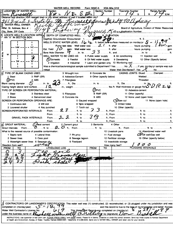
T14S, R14W, Sec. 3 NW NE SE |
Jefferies, Keith | 33 ft. | 16.5 ft. | 10 gpm. | Domestic | Constructed | 12-May-1999 | Scan | |
|
T14S, R14W, Sec. 3 NW NW NW |
New Oil Company of Kansas Inc. | 13 ft. | 5.61 ft. | Monitoring well/observation/piezometer | MW 6 | Constructed | 06-Aug-1998 | ||
| View page: < Prev || 21 || 22 || 23 || 24 || 25 || 26 || 27 || 28 || 29 || 30 || Next > | |||||||||