Select location of well to view details.
Click on column heading to sort.
|
|
|
County: Scott Select location of well to view details. Click on column heading to sort. |
|
|
|
| View page: < Prev || 11 || 12 || 13 || 14 || 15 || 16 || 17 || 18 || 19 || 20 || Next > | |||||||||
| T-R-S | Owner | Well Depth Ascend. Desc. |
Static Water Level Ascend. Desc. |
Est. Yield Ascend. Desc. |
Well Use | Other ID | Action Taken | Completion Date Ascend. Desc. |
Scan? |
|
T18S, R32W, Sec. 5 NE NE NW |
Deeds, Craig | 230 ft. | 164 ft. | 100 gpm. | Irrigation | Constructed | 11-Jun-2011 | ||
|
T18S, R32W, Sec. 5 SW SE NE |
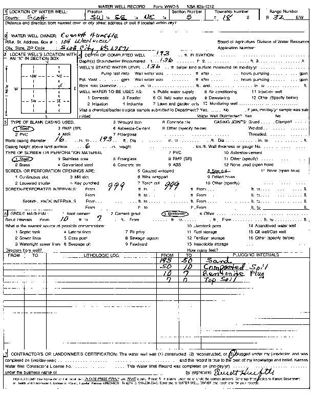
Hueftle, Everett | 193 ft. | 136 ft. | Domestic | Plugged | Scan | |||
|
T18S, R32W, Sec. 6 NE NE NE |
Deeds, Nellie | 264 ft. | 120 ft. | Domestic | Plugged | 10-Nov-1997 | |||
|
T18S, R32W, Sec. 6 NE NE NE |
Deeds, Nellie | 264 ft. | 120 ft. | 25 gpm. | Domestic | Constructed | 06-Nov-1997 | ||
|
T18S, R32W, Sec. 6 NE NE NE |
Deeds, Warren | 115 ft. | Domestic | Plugged | 20-Aug-1992 | ||||
|
T18S, R32W, Sec. 7 NE NE NW NW |
Berning, Jerome | 270 ft. | 156 ft. | 460 gpm. | Irrigation | Reconstructed | 24-Oct-2014 |
KOLAR |
|
|
T18S, R32W, Sec. 7 SE SW NE |
Filson Family Farms | 215 ft. | 150 ft. | 174 gpm. | Irrigation | Constructed | 08-May-2024 |
KOLAR |
|
|
T18S, R32W, Sec. 7 NE NW NW |
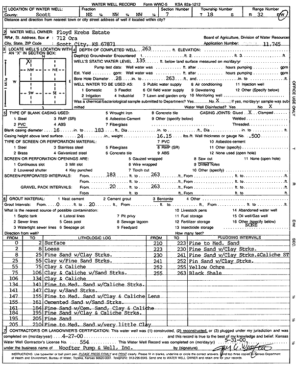
Floyd Krebs Estate | 263 ft. | 135 ft. | Irrigation | Reconstructed | 27-Apr-2000 | Scan | ||
|
T18S, R32W, Sec. 7 NE SE SE |
Hoeme, Robert and Allan | 150 ft. | 115 ft. | 15 gpm. | Domestic | Constructed | 15-Apr-1993 | ||
|
T18S, R32W, Sec. 7 NW NW SW |
Krebs, Floyd | 240 ft. | 127 ft. | Irrigation | Test 1 | Constructed | 13-Nov-1989 | ||
|
T18S, R32W, Sec. 7 NW NW SW |
Krebs, Floyd | 220 ft. | Irrigation | Plugged | 03-Dec-1989 | ||||
|
T18S, R32W, Sec. 7 SW SE SE |
Young, Frederick | 103 ft. | Irrigation | Plugged | 03-Jul-1990 | ||||
|
T18S, R32W, Sec. 7 SW SE NE |
Young, Frederick | 50 ft. | Irrigation | Plugged | 03-Jul-1990 | ||||
|
T18S, R32W, Sec. 8 SE NW SW |
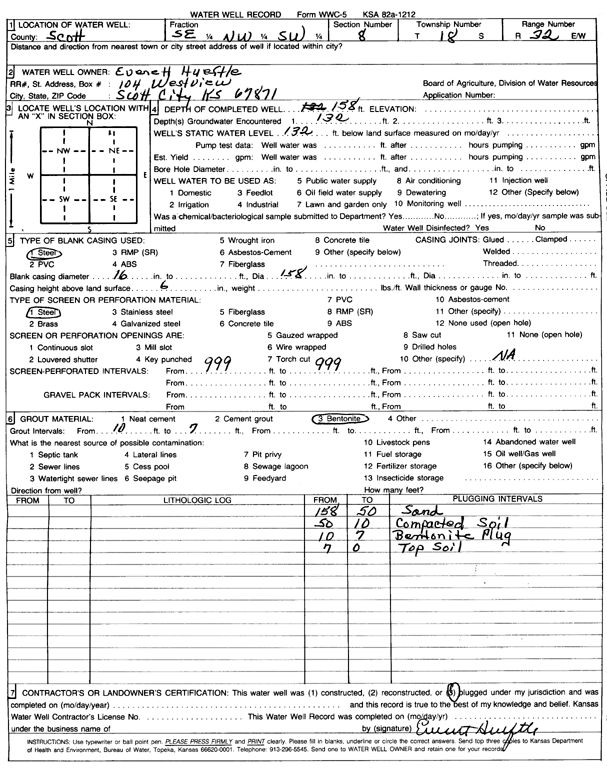
Hueftle, Everett | 158 ft. | 132 ft. | (unstated)/abandoned | Plugged | Scan | |||
|
T18S, R32W, Sec. 9 W2 W2 NW |
Erksin, Elmer | 124.67 ft. | 124 ft. | Irrigation | W well | Plugged | 01-Jun-1992 | ||
|
T18S, R32W, Sec. 9 E2 E2 NW |
Erskin, Elmer | 124 ft. | 157 ft. | Irrigation | Plugged | 18-Jun-2007 | |||
|
T18S, R32W, Sec. 9 SE NE NW |
Erskin, Elmer and Luella | 180 ft. | 126 ft. | Irrigation | Constructed | 25-May-2007 | |||
|
T18S, R32W, Sec. 9 SW SE SE SE |
Hineman, Andy | 170 ft. | 107 ft. | 25 gpm. | Domestic | Constructed | 21-Aug-2013 |
KOLAR |
|
|
T18S, R32W, Sec. 11 SW SE SE |
Carpenter, William G | 158 ft. | 92 ft. | 433 gpm. | Irrigation | Constructed | 18-Dec-1978 | ||
|
T18S, R32W, Sec. 11 NW NW SW |
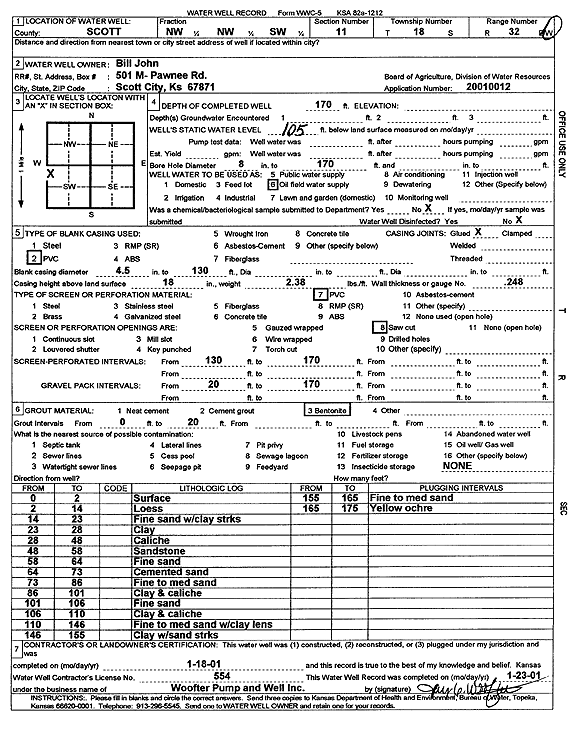
John, Bill | 170 ft. | 105 ft. | Oil Field Water Supply | Constructed | 18-Jan-2001 | Scan | ||
|
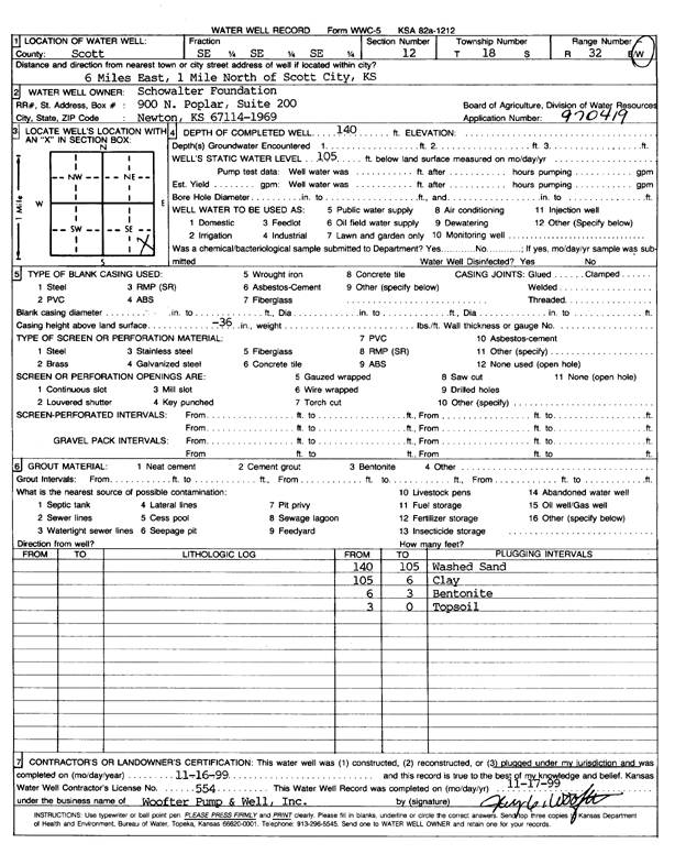
T18S, R32W, Sec. 12 SE SE SE |
Schowalter Foundation | 140 ft. | 105 ft. | Oil Field Water Supply | Plugged | 16-Nov-1999 | Scan | ||
|
T18S, R32W, Sec. 12 SE SE SE |
Schowalter Foundation | 140 ft. | 105 ft. | Oil Field Water Supply | Constructed | 19-Nov-1997 | |||
|
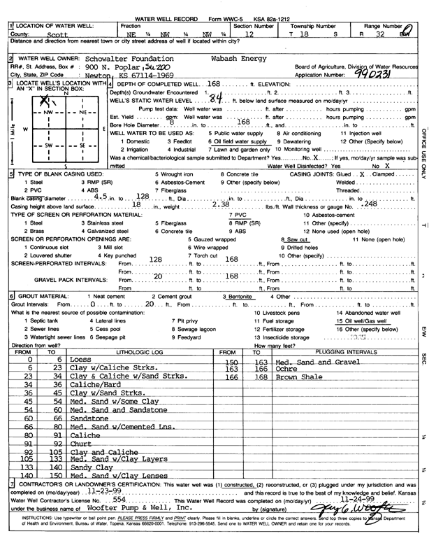
T18S, R32W, Sec. 12 NE NW NW |
Schowalter Foundation/Wabash Energy | 168 ft. | 84 ft. | Oil Field Water Supply | Constructed | 23-Nov-1999 | Scan | ||
|
T18S, R32W, Sec. 13 SE NW |
Beckley, Ruth/Wabash Energy | 165 ft. | 111 ft. | Oil Field Water Supply | Constructed | 28-Jul-1998 | |||
|
T18S, R32W, Sec. 14 NE SW SW |
Carpenter, Bill | 150 ft. | 100.67 ft. | Domestic | Constructed | 31-Jul-1990 | |||
|
T18S, R32W, Sec. 14 NE SW SW |
Carpenter, Bill | 108 ft. | 101 ft. | Domestic | Plugged | 23-Aug-1990 | |||
|
T18S, R32W, Sec. 14 SW SW SW |
John, Bill | 150 ft. | 109 ft. | 50 gpm. | Domestic | Constructed | 04-Aug-2020 | ||
|
T18S, R32W, Sec. 14 SE SE NE |
John, Bill | 160 ft. | 118 ft. | Domestic | Constructed | 25-Jun-1998 | |||
|
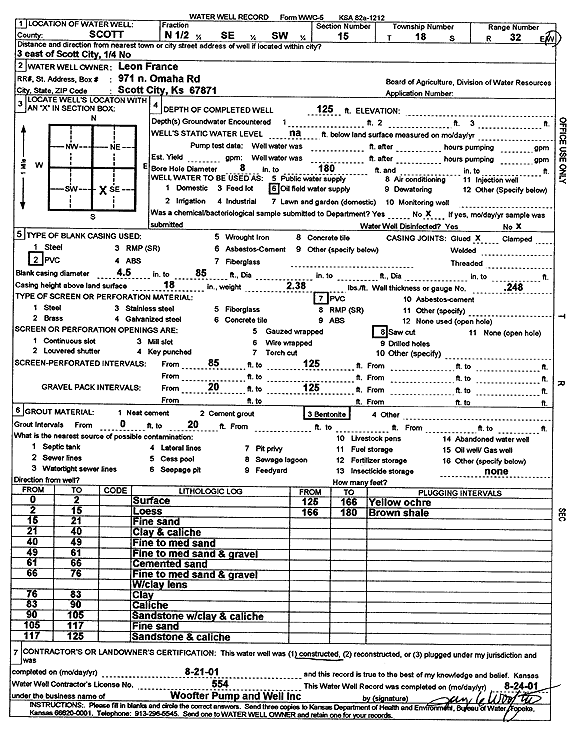
T18S, R32W, Sec. 15 N2 SE SW |
France, Leon | 125 ft. | Oil Field Water Supply | Constructed | 21-Aug-2001 | Scan | |||
|
T18S, R32W, Sec. 16 NW SW NW |
Agri Biz/Dearden, Larry | 139.58 ft. | 137.17 ft. | Domestic, Livestock | Plugged | 17-Jul-2015 | |||
|
T18S, R32W, Sec. 16 NE NE NW |
C A Steele and Sons | 145 ft. | 96 ft. | 320 gpm. | Irrigation | Constructed | 02-Jul-1975 | ||
|
T18S, R32W, Sec. 16 SW NW NW |
C A Steele and Sons | 145 ft. | 115 ft. | Domestic, Livestock | Constructed | 10-Sep-1984 | |||
|
T18S, R32W, Sec. 16 NW NE NW |
C A Steele and Sons | 145 ft. | 96 ft. | 410 gpm. | Irrigation | Constructed | 02-Jul-1975 | ||
|
T18S, R32W, Sec. 17 NW SW SE |
Bailey, Gary | 164 ft. | 129 ft. | 25 gpm. | Domestic | Constructed | 08-Mar-2017 | ||
|
T18S, R32W, Sec. 17 SE SE SE |
Berry, Roy | 165 ft. | 110 ft. | 200 gpm. | Domestic | Constructed | 01-Aug-1977 | ||
|
T18S, R32W, Sec. 17 NW NW NE |
Burnett, H R | 176 ft. | 125 ft. | 100 gpm. | Domestic, Livestock | Constructed | 30-Jan-1977 | ||
|
T18S, R32W, Sec. 17 NE NW NE |
Burnett, Harold | 154 ft. | 145 ft. | Domestic | Plugged | 22-Mar-2018 | |||
|
T18S, R32W, Sec. 17 NE NW NE |
Burnett, Harold | 165 ft. | 144 ft. | 35 gpm. | Domestic | Constructed | 07-Mar-2018 | ||
|
T18S, R32W, Sec. 17 SE NE SE |
Burnett, Harold | 19 ft. | Domestic, Livestock | Plugged | 27-Jan-2014 | ||||
|
T18S, R32W, Sec. 17 NE NE NW |
Burnett, Harold | 108 ft. | Irrigation | Plugged | 11-Jun-2014 | ||||
|
T18S, R32W, Sec. 17 NW SW SW |
City of Scott City | 168 ft. | 140 ft. | Test hole/well | Plugged | 05-Aug-2025 |
KOLAR |
||
|
T18S, R32W, Sec. 17 NE SW SW |
City of Scott City | 199 ft. | 144 ft. | 238 gpm. | Public Water Supply | Well 12 | Constructed | 09-Apr-2025 |
KOLAR |
|
T18S, R32W, Sec. 17 NW SW SW |
City of Scott City | 180 ft. | 140 ft. | Test hole/well | Plugged | 05-Aug-2025 |
KOLAR |
||
|
T18S, R32W, Sec. 17 SE SE SE |
Eaton, Ronald | 155 ft. | 94 ft. | 50 gpm. | Domestic | Constructed | 30-May-1980 | ||
|
T18S, R32W, Sec. 17 NE SE SE |
Erskin, Elmer | 160 ft. | 109 ft. | 15 gpm. | Other | Constructed | 11-Dec-1991 | ||
|
T18S, R32W, Sec. 17 NE SE SE |
Gamble, Gene | 170 ft. | 110 ft. | Domestic | Constructed | 18-May-1979 | |||
|
T18S, R32W, Sec. 17 SW SW SE |
Gamble, Gene | 168 ft. | 105 ft. | 36 gpm. | Domestic | Constructed | 28-May-1993 | ||
|
T18S, R32W, Sec. 17 NW SW SW |
Lawrence, Gabe | 181 ft. | 130 ft. | 400 gpm. | Monitoring well/observation/piezometer | Constructed | 03-Jun-2009 | ||
|
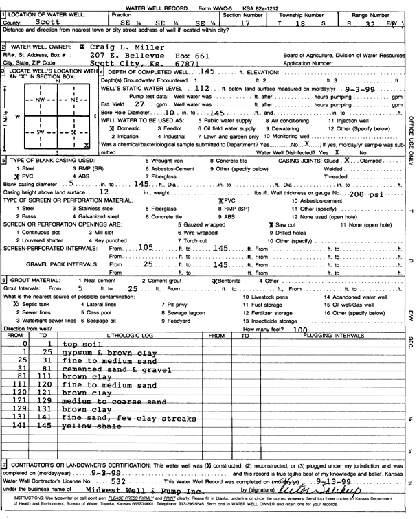
T18S, R32W, Sec. 17 SE SE SE |
Miller, Craig L. | 145 ft. | 112 ft. | 27 gpm. | Domestic | Constructed | 03-Sep-1999 | Scan | |
|
T18S, R32W, Sec. 17 SE NE SE |
Pitman, Wesley | 150 ft. | 88 ft. | 10 gpm. | Domestic | Constructed | 08-Aug-1975 | ||
| View page: < Prev || 11 || 12 || 13 || 14 || 15 || 16 || 17 || 18 || 19 || 20 || Next > | |||||||||