Select location of well to view details.
Click on column heading to sort.
|
|
|
County: Seward Select location of well to view details. Click on column heading to sort. |
|
|
|
| View page: < Prev || 11 || 12 || 13 || 14 || 15 || 16 || 17 || 18 || 19 || 20 || Next > | |||||||||
| T-R-S | Owner | Well Depth Ascend. Desc. |
Static Water Level Ascend. Desc. |
Est. Yield Ascend. Desc. |
Well Use | Other ID | Action Taken | Completion Date Ascend. Desc. |
Scan? |
|
T32S, R33W, Sec. 9 NW |
Specht, Glenn | 400 ft. | 192 ft. | 60 gpm. | Domestic | Constructed | 15-May-1985 | ||
|
T32S, R33W, Sec. 9 NE NE |
Zenith Drilling | 260 ft. | 160 ft. | 80 gpm. | Oil Field Water Supply | Specht 1 | Constructed | 21-Dec-1993 | |
|
T32S, R33W, Sec. 10 NE SE |
Harris Oil and Gas | 340 ft. | 223 ft. | 75 gpm. | Oil Field Water Supply | D. Johnson 1-10 | Constructed | 10-Aug-1985 | |
|
T32S, R33W, Sec. 13 SE SW SE |
Elder and Vaughn | 360 ft. | 160 ft. | Oil Field Water Supply | Clawson 1-13 | Plugged | 23-Jan-1996 | ||
|
T32S, R33W, Sec. 13 SE SW SE |
Elder and Vaughn | 360 ft. | 160 ft. | 90 gpm. | Oil Field Water Supply | Clawson 1-13 | Constructed | 26-Dec-1995 | |
|
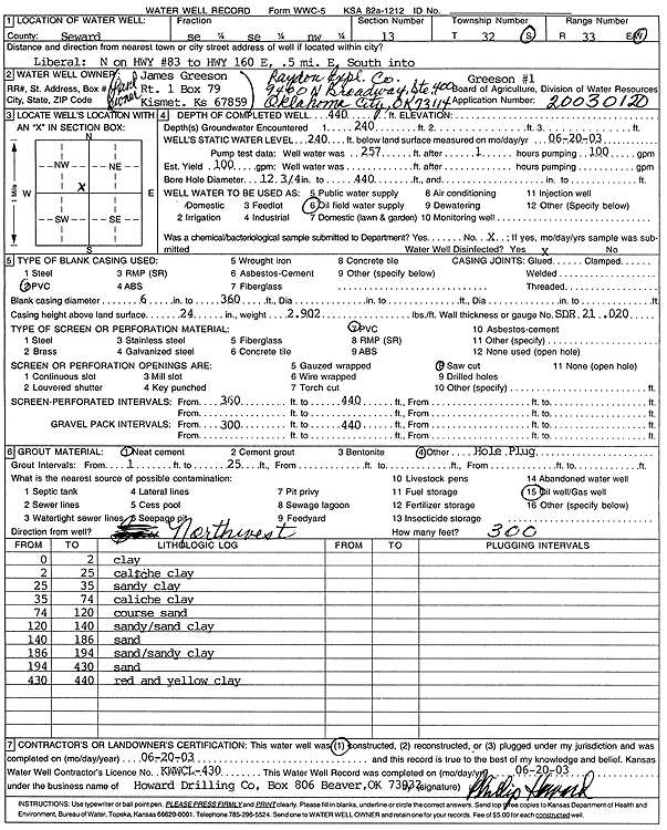
T32S, R33W, Sec. 13 SE SE NW |
James Greeson/Raydon Exploration Co. | 440 ft. | 240 ft. | 100 gpm. | Oil Field Water Supply | Constructed | 20-Jun-2003 | Scan | |
|
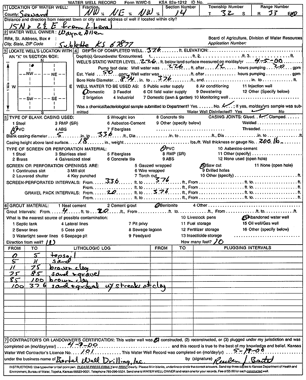
T32S, R33W, Sec. 14 NW NE NW |
Allen, Wayne | 376 ft. | 226 ft. | Domestic | Constructed | 07-Apr-2000 | Scan | ||
|
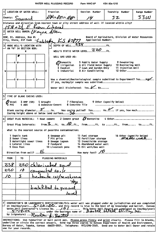
T32S, R33W, Sec. 14 NW NE NW |
Allen, Wayne | 238 ft. | 220 ft. | Domestic | Plugged | 20-May-2000 | Scan | ||
|
T32S, R33W, Sec. 14 C SW |
Service Drilling Co. | 300 ft. | 180 ft. | 40 gpm. | Oil Field Water Supply | Printz 1 | Constructed | 25-May-1977 | |
|
T32S, R33W, Sec. 14 C SE SW |
Service Drilling Co. | 280 ft. | 150 ft. | 50 gpm. | Oil Field Water Supply | B H Lemert | Constructed | 12-May-1977 | |
|
T32S, R33W, Sec. 14 NE SW SW |
Unit Drilling Co | 200 ft. | 100 ft. | 45 gpm. | Industrial | Lemert Trent 2-14 | Constructed | 18-Jun-1975 | |
|
T32S, R33W, Sec. 15 SE SW SE NE |
Allen, Wayne | 400 ft. | 265 ft. | 50 gpm. | Domestic, Livestock | Constructed | 05-Aug-2016 |
KOLAR |
|
|
T32S, R33W, Sec. 15 SE SE |
Amoco Production Co | 240 ft. | 135 ft. | 40 gpm. | Oil Field Water Supply | Edna Scott 1 | Constructed | 16-Apr-1975 | |
|
T32S, R33W, Sec. 15 NW SW |
Rains and Williamson Oil Co. | 220 ft. | 120 ft. | 60 gpm. | Oil Field Water Supply | Hettie Jones 2-15 | Constructed | 26-Aug-1976 | |
|
T32S, R33W, Sec. 15 SW NE |
Service Drilling Co. | 280 ft. | 185 ft. | 50 gpm. | Oil Field Water Supply | Constructed | 15-Jun-1977 | ||
|
T32S, R33W, Sec. 15 SESW |
Service Drilling Co. | 220 ft. | 102 ft. | 50 gpm. | Oil Field Water Supply | Constructed | 16-Apr-1977 | ||
|
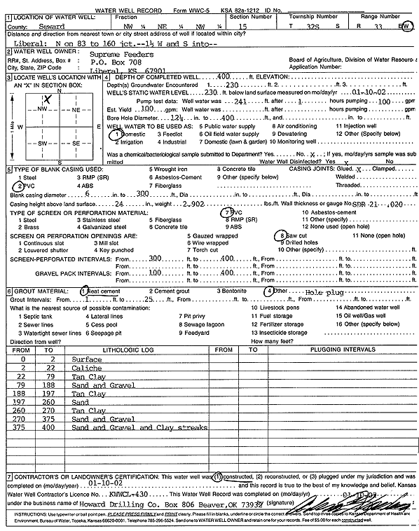
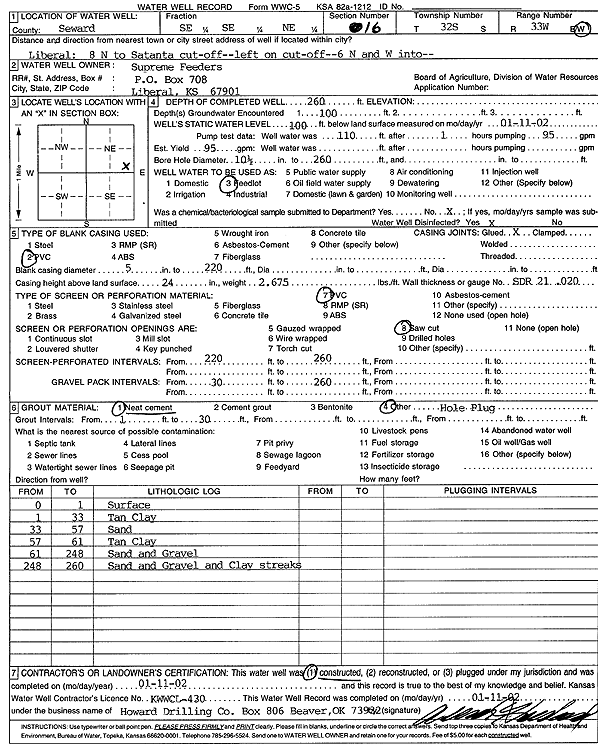
T32S, R33W, Sec. 15 NW NE NW |
Supreme Feeders | 400 ft. | 230 ft. | 100 gpm. | Domestic | Constructed | 10-Jan-2002 | Scan | |
|
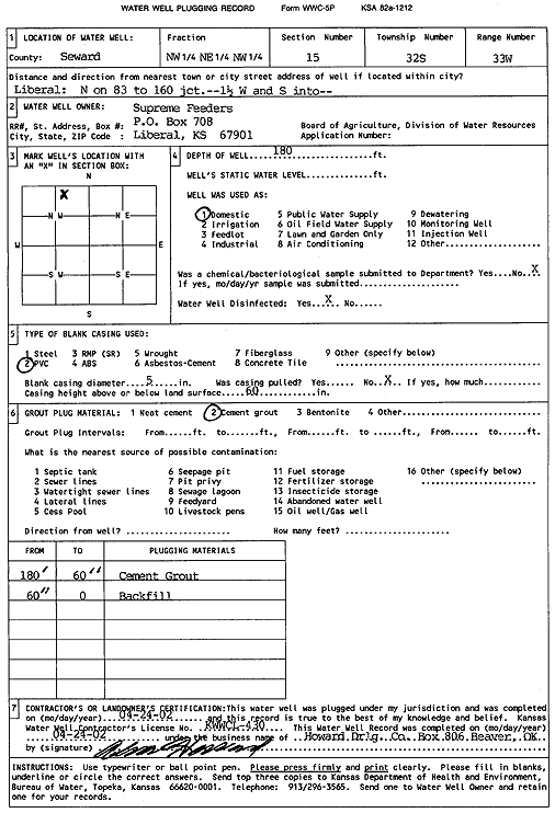
T32S, R33W, Sec. 15 NW NE NW |
Supreme Feeders | 180 ft. | Domestic | Plugged | 24-Apr-2002 | Scan | |||
|
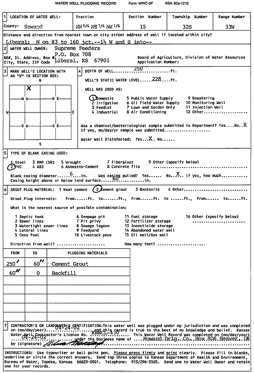
T32S, R33W, Sec. 15 NW NE NW |
Supreme Feeders | 250 ft. | 228 ft. | Domestic | Plugged | 24-Apr-2002 | Scan | ||
|
T32S, R33W, Sec. 15 NW NW |
Supreme Feeders Inc | 300 ft. | 167 ft. | 50 gpm. | Domestic | WW 4 | Constructed | 27-Jul-1976 | |
|
T32S, R33W, Sec. 15 C NW |
Whitman, Bill | 280 ft. | 179 ft. | 65 gpm. | Domestic | Constructed | 28-Apr-1979 | ||
|
T32S, R33W, Sec. 16 C SE |
Mustang Drilling | 280 ft. | 155 ft. | 65 gpm. | Oil Field Water Supply | Frantz | Constructed | 10-Mar-1985 | |
|
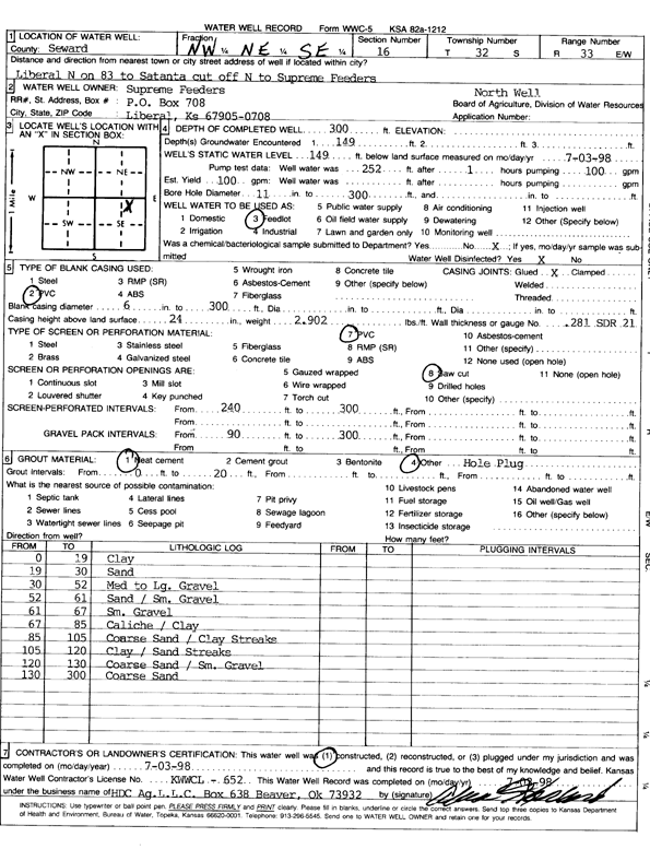
T32S, R33W, Sec. 16 NW NE SE |
Supreme Feeders | 300 ft. | 149 ft. | Feedlot | North Well | Constructed | 03-Jul-1998 | Scan | |
|
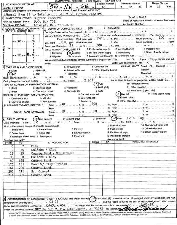
T32S, R33W, Sec. 16 SW NW SE |
Supreme Feeders | 300 ft. | 140 ft. | Feedlot | South Well | Constructed | 02-Jul-1998 | Scan | |
|
T32S, R33W, Sec. 16 NE SE NE |
Supreme Feeders | 446 ft. | 175 ft. | 2500 gpm. | Feedlot | Constructed | 27-Sep-1982 | ||
|
T32S, R33W, Sec. 16 SE SE NE |
Supreme Feeders | 260 ft. | 100 ft. | 95 gpm. | Feedlot/Livestock/Windmill | Constructed | 11-Jan-2002 | Scan | |
|
T32S, R33W, Sec. 16 NW NW NW |
Supreme Feeders Inc | 381 ft. | 122 ft. | 1600 gpm. | Irrigation | Constructed | 10-Dec-1991 | ||
|
T32S, R33W, Sec. 16 SW SE SE |
Supreme Feeders Inc | 415 ft. | 164 ft. | 1400 gpm. | Irrigation | Constructed | 10-Dec-1991 | ||
|
T32S, R33W, Sec. 17 NE NE NW |
Alexander, Scotty | 330 ft. | 140 ft. | 25 gpm. | Domestic | 1 Elog No | Constructed | 21-Aug-1979 | |
|
T32S, R33W, Sec. 17 SE NW NW |
Supreme Feeders | 350 ft. | 210 ft. | 70 gpm. | Oil Field Water Supply | Johnson 2-17 | Constructed | 10-Mar-1992 | |
|
T32S, R33W, Sec. 18 NW NW SW |
Boles Land and Cattle | 260 ft. | 103 ft. | Irrigation | Constructed | 13-May-2023 |
KOLAR |
||
|
T32S, R33W, Sec. 18 NE SW NE |
Boles, Paul | 150 ft. | 18.5 ft. | 3200 gpm. | Irrigation | Constructed | 11-May-1976 | ||
|
T32S, R33W, Sec. 19 C SW SW |
Cabot Oil and Gas | 280 ft. | 100 ft. | 100 gpm. | Oil Field Water Supply | Hitch 1-19 | Constructed | 29-Dec-1992 | |
|
T32S, R33W, Sec. 19 SE NE NE |
Supreme Feeders | 175 ft. | 63 ft. | 100 gpm. | Domestic | Constructed | 12-Sep-2003 | ||
|
T32S, R33W, Sec. 20 SW NE NE |
Cabot Oil and Gas | 280 ft. | 80 ft. | 110 gpm. | Oil Field Water Supply | Mercer 2-20 | Constructed | 30-Oct-1991 | |
|
T32S, R33W, Sec. 20 NW SE SE |
Mercer, Homer | 150 ft. | 14 ft. | 3000 gpm. | Irrigation | Constructed | 14-May-1976 | ||
|
T32S, R33W, Sec. 20 SE NE NE |
Supreme Feeders | 200 ft. | 63 ft. | 100 gpm. | Domestic | Constructed | 15-Sep-2003 | ||
|
T32S, R33W, Sec. 20 SE NW SW |
Supreme Feeders | 338 ft. | 87 ft. | 50 gpm. | Domestic, Livestock | Constructed | 05-Sep-2013 | ||
|
T32S, R33W, Sec. 20 NW SW NE |
Supreme Feeders | 215 ft. | 45 ft. | 1410 gpm. | Irrigation | Constructed | 28-Oct-1996 | ||
|
T32S, R33W, Sec. 21 SE SE SW |
Mercer, Homer | 59 ft. | 18 ft. | Domestic | Plugged | 16-Jun-1988 | |||
|
T32S, R33W, Sec. 21 SE SE SW |
Mercer, Homer | 100 ft. | 36 ft. | Domestic | Constructed | 01-Jun-1988 | |||
|
T32S, R33W, Sec. 22 C NW NW |
Lemert, Mildred/Gulf Oil Company | 260 ft. | 123 ft. | 75 gpm. | Oil Field Water Supply | Bettie Lemert 2-22 | Constructed | 08-Aug-1984 | |
|
T32S, R33W, Sec. 22 C NW NE |
Service Drilling Co. | 280 ft. | 150 ft. | 50 gpm. | Oil Field Water Supply | Constructed | 29-Apr-1977 | ||
|
T32S, R33W, Sec. 23 NW NW |
Rains and Williamson Oil Co. | 260 ft. | 120 ft. | 60 gpm. | Oil Field Water Supply | Baughman 1 U | Constructed | 04-Aug-1976 | |
|
T32S, R33W, Sec. 24 C SW SW |
Murfin Drilling Co., Inc | 260 ft. | 95 ft. | 100 gpm. | Oil Field Water Supply | Lemert | Constructed | 05-Mar-1983 | |
|
T32S, R33W, Sec. 24 NE SW |
Sage Drilling Co | 200 ft. | 95 ft. | 60 gpm. | Oil Field Water Supply | Kane-Baughman 1 | Constructed | 02-Nov-1977 | |
|
T32S, R33W, Sec. 25 C SW |
Kane, Don | 230 ft. | 47 ft. | 3500 gpm. | Irrigation | Constructed | 11-Sep-1975 | ||
|
T32S, R33W, Sec. 25 SW NE NW |
Oxy USA, Inc. | 320 ft. | 148 ft. | 100 gpm. | Oil Field Water Supply | Baughman K 3 | Constructed | 27-Jan-2005 | |
|
T32S, R33W, Sec. 25 NE NE SW |
Rinehart, Mike | 240 ft. | 71 ft. | 100 gpm. | Domestic | Constructed | 10-Sep-1997 | Scan | |
|
T32S, R33W, Sec. 25 SW NE |
Rinehart, Mike | 80 ft. | Domestic | Plugged | 18-Aug-2007 | ||||
| View page: < Prev || 11 || 12 || 13 || 14 || 15 || 16 || 17 || 18 || 19 || 20 || Next > | |||||||||