Select location of well to view details.
Click on column heading to sort.
|
|
|
County: Sherman Select location of well to view details. Click on column heading to sort. |
|
|
|
| View page: 1 || 2 || 3 || 4 || 5 || 6 || 7 || 8 || 9 || 10 || Next > | |||||||||
| T-R-S | Owner | Well Depth Ascend. Desc. |
Static Water Level Ascend. Desc. |
Est. Yield Ascend. Desc. |
Well Use | Other ID | Action Taken | Completion Date Ascend. Desc. |
Scan? |
|---|---|---|---|---|---|---|---|---|---|
|
T9S, R42W, Sec. 14 NE NE NE |
Kansas Geological Survey | 282 ft. | 129.4 ft. | Monitoring well/observation/piezometer | 9-42-14 AAA 01 | Constructed | 22-Oct-1964 | ||
|
T9S, R42W, Sec. 8 NE NE NE |
Kansas Geological Survey | 265 ft. | 131.89 ft. | Monitoring well/observation/piezometer | 9-42-8 AAA 01 | Constructed | 21-Oct-1964 | ||
|
T8S, R39W, Sec. 20 SW NW SW |
Bishop, Bill | 209.7 ft. | 201.95 ft. | Monitoring well/observation/piezometer | AS 1 | Plugged | 12-Feb-2013 | ||
|
T6S, R37W, Sec. 34 NE NE NE SE |
Questa Energy Corp. | 280 ft. | 190 ft. | 50 gpm. | Oil Field Water Supply | Bear 34-1 | Constructed | 04-Apr-2018 |
KOLAR |
|
T6S, R38W, Sec. 9 NW NE NE NW |
Beims, Ron | 295 ft. | 180 ft. | 60 gpm. | Oil Field Water Supply | Beims 1-9 | Constructed | 12-Oct-2016 |
KOLAR |
|
T6S, R38W, Sec. 9 NW NE NE NW |
Beims, Ron | 295 ft. | 180 ft. | Oil Field Water Supply | Beims 1-9 | Plugged | 09-Nov-2016 |
KOLAR |
|
|
T8S, R39W, Sec. 18 SW SW SW |
Sherman County | 221.5 ft. | 188.91 ft. | Monitoring well/observation/piezometer | BH 3/MW 1 | Constructed | 10-Aug-1998 | ||
|
T7S, R37W, Sec. 23 NE NW SW SW |
Brito Oil Co. | 280 ft. | 180 ft. | 50 gpm. | Oil Field Water Supply | Carpenter 'A' 1-23 | Constructed | 06-Jun-2017 |
KOLAR |
|
T6S, R37W, Sec. 1 SE NE SW NE |
Cutshaw, Agnes | 300 ft. | 150 ft. | 75 gpm. | Oil Field Water Supply | Cutshaw-Lee 1 | Constructed | 30-Mar-2013 |
KOLAR |
|
T6S, R37W, Sec. 1 SE NE SW NE |
Cutshaw, Agnes | 300 ft. | 150 ft. | 75 gpm. | Oil Field Water Supply | Cutshaw-Lee 1 | Plugged | 15-Apr-2013 |
KOLAR |
|
T6S, R42W, Sec. 26 NE NE NE NW |
Wise, Bret | 300 ft. | Irrigation | D2 | Plugged | 10-Feb-2012 | |||
|
T7S, R37W, Sec. 14 NE SE NE NE |
Brito Oil Co. | 280 ft. | 190 ft. | Oil Field Water Supply | Egeland 1-14 | Plugged | 13-Mar-2018 |
KOLAR |
|
|
T7S, R37W, Sec. 14 NE SE NE NE |
Brito Oil Co. | 280 ft. | 190 ft. | 70 gpm. | Oil Field Water Supply | Egeland 1-14 | Constructed | 01-Feb-2018 |
KOLAR |
|
T6S, R38W, Sec. 23 NE NW NW NE |
Finegan, Evelyn | 202 ft. | 120 ft. | 30 gpm. | Oil Field Water Supply | Finnegan 1-23 | Constructed | 12-Aug-2013 |
KOLAR |
|
T6S, R37W, Sec. 16 SE SE NW NW |
Hoyt, Leone | 278 ft. | 120 ft. | 30 gpm. | Oil Field Water Supply | Hoyt 4-14 | Constructed | 13-Aug-2013 |
KOLAR |
|
T8S, R39W, Sec. 19 NW SW SE NE |
Prints and the Paper | 222.15 ft. | 208.05 ft. | Environmental Remediation, Injection | IW 1 | Plugged | 18-Apr-2017 |
KOLAR |
|
|
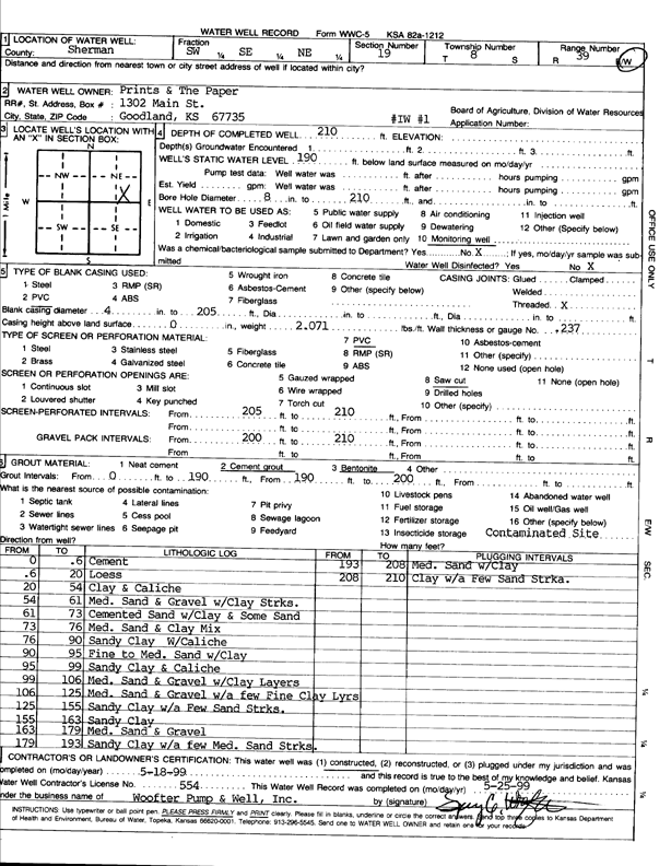
T8S, R39W, Sec. 19 SW SE NE |
Prints and the Paper | 210 ft. | 190 ft. | Monitoring well/observation/piezometer | IW 1 | Constructed | 18-May-1999 | Scan | |
|
T6S, R37W, Sec. 12 SE SW NW |
Black Oak Exploration | 300 ft. | 200 ft. | Oil Field Water Supply | Miller 1-12 | Plugged | 27-Dec-2022 |
KOLAR |
|
|
T6S, R37W, Sec. 12 SE SW NW |
Black Oak Exploration | 300 ft. | 200 ft. | 50 gpm. | Oil Field Water Supply | Miller 1-12 | Constructed | 30-Nov-2022 |
KOLAR |
|
T8S, R38W, Sec. 22 NE SW SE |
Edson Agri Services | 162.22 ft. | 159.8 ft. | Monitoring well/observation/piezometer | MW 1 | Plugged | 13-Oct-2006 | ||
|
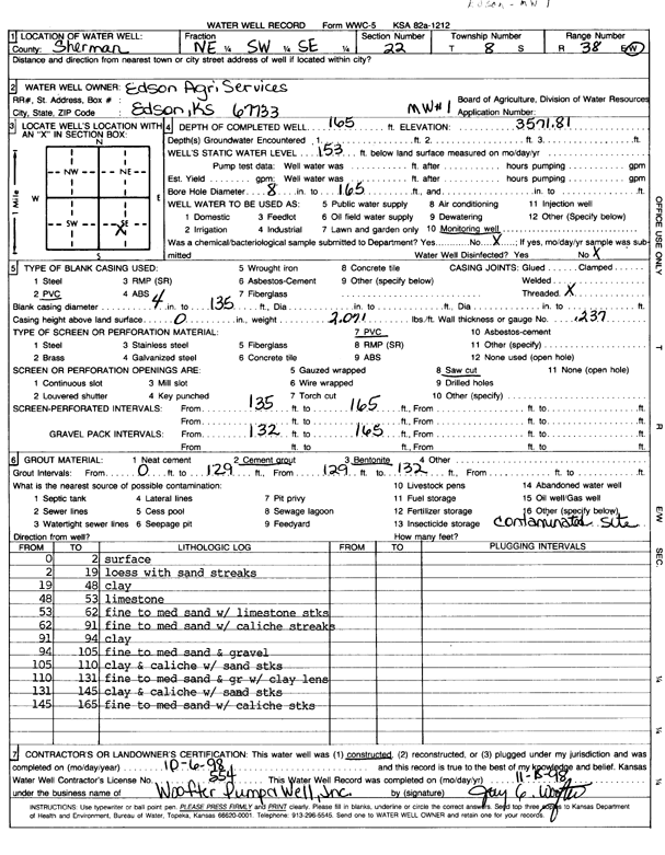
T8S, R38W, Sec. 22 NE SW SE |
Edson Agricultural Services | 165 ft. | 153 ft. | Monitoring well/observation/piezometer | MW 1 | Constructed | 06-Oct-1998 | Scan | |
|
T8S, R39W, Sec. 8 NE NE NE |
Sherman County | 227 ft. | 144 ft. | Monitoring well/observation/piezometer | MW 1 | Constructed | 13-May-1987 | ||
|
T8S, R39W, Sec. 18 SE SE SE |
Kabredlo's | 211.34 ft. | 188.92 ft. | Monitoring well/observation/piezometer | MW 1 | Plugged | 04-Feb-2008 | ||
|
T8S, R39W, Sec. 19 SE NE SE |
Coastal Mart, Inc. | 206 ft. | 189 ft. | Monitoring well/observation/piezometer | MW 1 | Constructed | 19-Mar-2002 | ||
|
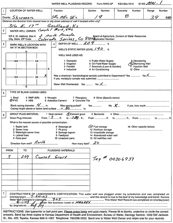
T8S, R39W, Sec. 19 SE NE SE |
Coastal Mart, Inc. | 209 ft. | 190 ft. | Monitoring well/observation/piezometer | MW 1 | Plugged | 24-Jul-2003 | Scan | |
|
T8S, R39W, Sec. 19 NW NE NE |
Dave's Auto Repair | 205 ft. | 187.32 ft. | Monitoring well/observation/piezometer | MW 1 | Constructed | 17-Sep-1997 | ||
|
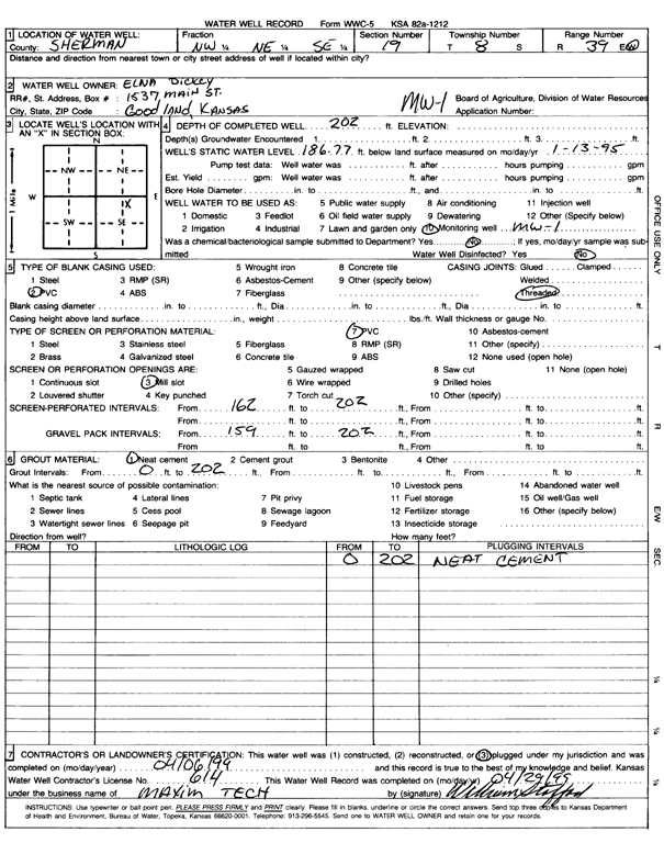
T8S, R39W, Sec. 19 NW NE SE |
Dickey, Elna | 202 ft. | 186.77 ft. | Monitoring well/observation/piezometer | MW 1 | Constructed | 12-Jan-1995 | ||
|
T8S, R39W, Sec. 19 NW NE SE |
Dickey, Elna | 202 ft. | 186.77 ft. | Monitoring well/observation/piezometer | MW 1 | Plugged | 06-Apr-1999 | Scan | |
|
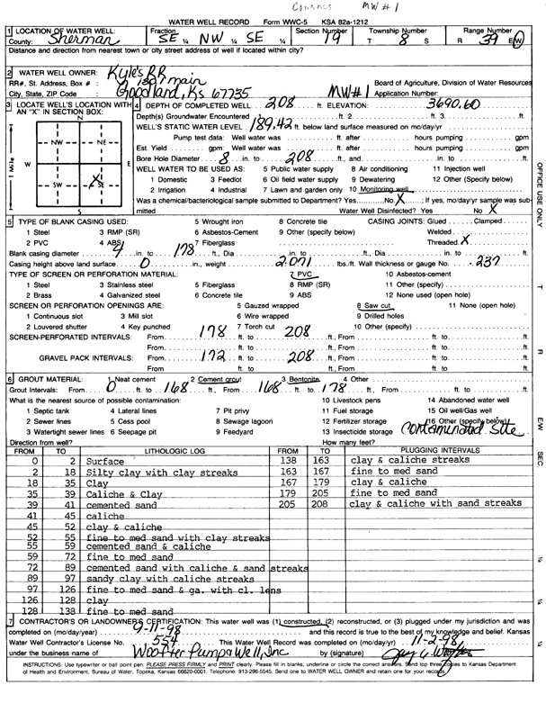
T8S, R39W, Sec. 19 SE NW SE |
Kyle Railroad | 208 ft. | 189.42 ft. | Monitoring well/observation/piezometer | MW 1 | Constructed | 11-Sep-1998 | Scan | |
|
T8S, R39W, Sec. 19 NE SE NW SE |
Kyle Railroad Co. | 208 ft. | 208 ft. | Monitoring well/observation/piezometer | MW 1 | Plugged | 10-Oct-2018 |
KOLAR |
|
|
T8S, R39W, Sec. 19 NW SW SE NE |
Prints and the Paper | 224.06 ft. | 208.06 ft. | Monitoring well/observation/piezometer | MW 1 | Plugged | 19-Apr-2017 |
KOLAR |
|
|
T8S, R39W, Sec. 19 SW SE NE |
Prints and the Paper | 215 ft. | 190.22 ft. | Monitoring well/observation/piezometer | MW 1 | Constructed | 14-Mar-1998 | ||
|
T8S, R39W, Sec. 19 SW SW SW SW |
Short & Son, Inc | 201.8 ft. | Monitoring well/observation/piezometer | MW 1 | Plugged | 20-Dec-2019 | |||
|
T8S, R39W, Sec. 19 SW SW SW |
Short and Sons | 210 ft. | 187 ft. | Monitoring well/observation/piezometer | MW 1 | Constructed | 14-Apr-1992 | ||
|
T8S, R39W, Sec. 20 SW NW SW |
Bishop, Bill | 209.85 ft. | 202.22 ft. | Monitoring well/observation/piezometer | MW 1 | Plugged | 12-Feb-2013 | ||
|
T8S, R39W, Sec. 20 SE NW SW |
City of Goodland | 207 ft. | 187.94 ft. | Monitoring well/observation/piezometer | MW 1 | Constructed | 20-Sep-1993 | ||
|
T8S, R39W, Sec. 29 SW NE SE NE |
Stage Stop Ventures | 215 ft. | 186.08 ft. | Monitoring well/observation/piezometer | MW 1 | Constructed | 28-Mar-2005 | ||
|
T8S, R39W, Sec. 29 NE SE NE |
Stage Stop Ventures | 215 ft. | 189.15 ft. | Monitoring well/observation/piezometer | MW 1 | Plugged | 06-Oct-2006 | ||
|
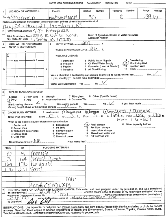
T8S, R39W, Sec. 30 NW NW NW |
4 Js Enterprises | 207 ft. | 186 ft. | Monitoring well/observation/piezometer | MW 1 | Plugged | 28-Feb-2000 | Scan | |
|
T8S, R39W, Sec. 30 NW NW NW |
4 Js Enterprises | 207 ft. | 186 ft. | Monitoring well/observation/piezometer | MW 1 | Constructed | 07-Jul-1994 | ||
|
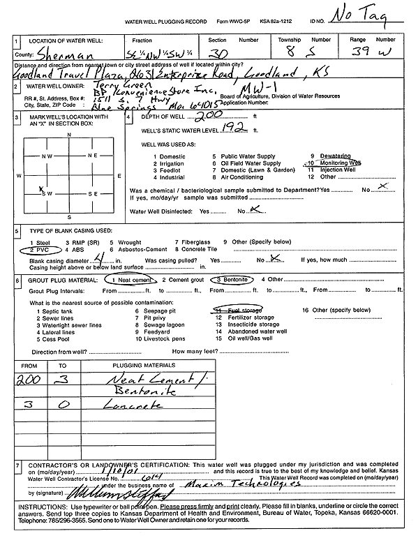
T8S, R39W, Sec. 30 SE NW SW |
BP Convenience Store | 200 ft. | 192 ft. | Monitoring well/observation/piezometer | MW 1 | Plugged | 10-Jan-2001 | Scan | |
|
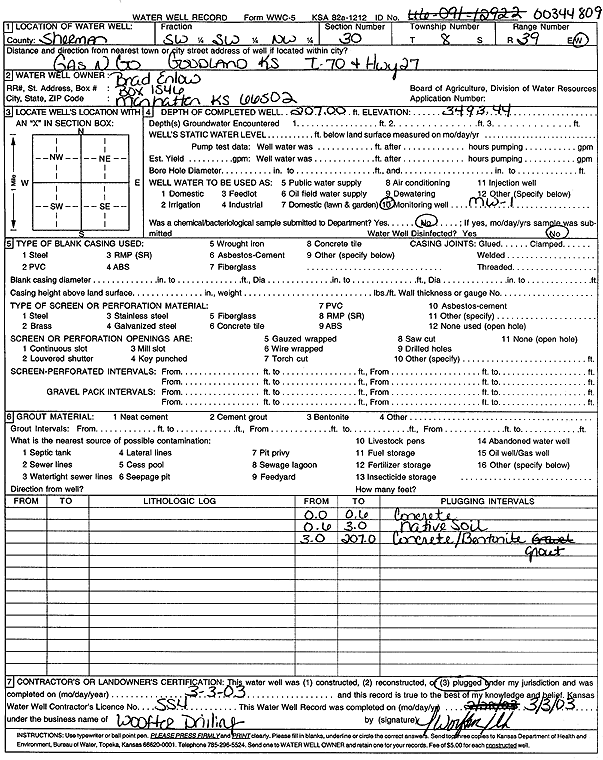
T8S, R39W, Sec. 30 SW SW NW |
Enlow, Brad | 207 ft. | Monitoring well/observation/piezometer | MW 1 | Plugged | 03-Mar-2003 | Scan | ||
|
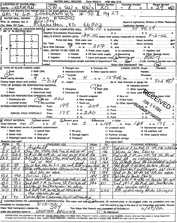
T8S, R39W, Sec. 30 SW SW NW |
Enlow, Brad | 206.1 ft. | 187.75 ft. | Monitoring well/observation/piezometer | MW 1 | Constructed | 12-Mar-2002 | Scan | |
|
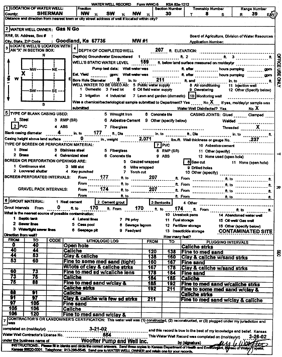
T8S, R39W, Sec. 30 NW SW NW |
Gas N Go | 207 ft. | 189 ft. | Monitoring well/observation/piezometer | MW 1 | Constructed | 21-Mar-2002 | Scan | |
|
T8S, R39W, Sec. 30 SW NW NW |
Goodland Travel Plaza | 202 ft. | 180.2 ft. | Monitoring well/observation/piezometer | MW 1 | Constructed | 18-Feb-1995 | ||
|
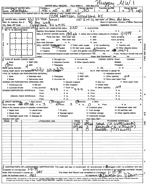
T8S, R39W, Sec. 30 NE NE NE |
Northwest Kansas Technical School | 220 ft. | 189.66 ft. | Monitoring well/observation/piezometer | MW 1 | Plugged | 11-Jan-1999 | Scan | |
|
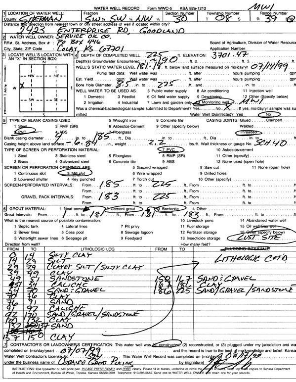
T8S, R39W, Sec. 30 SW SW NW |
Service Oil Co. | 225 ft. | 186 ft. | Monitoring well/observation/piezometer | MW 1 | Plugged | 24-Aug-2005 | ||
|
T8S, R39W, Sec. 30 SW SW NW |
Service Oil Co. | 225 ft. | 181.18 ft. | Monitoring well/observation/piezometer | MW 1 | Constructed | 07-Jul-1999 | Scan | |
|
T8S, R40W, Sec. 24 SW SE SE |
Frontier Ag | 210 ft. | Monitoring well/observation/piezometer | MW 1 | Plugged | 07-Aug-2008 | |||
|
T8S, R40W, Sec. 25 NE SE NE |
Barnett Oil Co. | 220 ft. | 184 ft. | Monitoring well/observation/piezometer | MW 1 | Plugged | 01-Jun-2005 | ||
| View page: 1 || 2 || 3 || 4 || 5 || 6 || 7 || 8 || 9 || 10 || Next > | |||||||||