Select location of well to view details.
Click on column heading to sort.
|
|
|
County: Stanton Select location of well to view details. Click on column heading to sort. |
|
|
|
| View page: < Prev || 11 || 12 || 13 || 14 || 15 || 16 || 17 || 18 || 19 || 20 || Next > | |||||||||
| T-R-S | Owner | Well Depth Ascend. Desc. |
Static Water Level Ascend. Desc. |
Est. Yield Ascend. Desc. |
Well Use | Other ID | Action Taken | Completion Date Ascend. Desc. |
Scan? |
|
T28S, R43W, Sec. 32 NW NE NE |
Toole, Mike | 307 ft. | 163 ft. | 12 gpm. | Domestic | Constructed | 04-Jan-2006 | ||
|
T29S, R39W, Sec. 1 SW SE SW |
Garey, Melvin | 553 ft. | 317 ft. | Irrigation | Constructed | 05-Jun-2008 | |||
|
T29S, R39W, Sec. 1 SE SE SE |
Shultz, Roger | 400 ft. | 180 ft. | 25 gpm. | Domestic | Constructed | 28-Dec-1979 | ||
|
T29S, R39W, Sec. 2 NW NW NW |
ADM Collingwood Grain | 176 ft. | 133.9 ft. | Monitoring well/observation/piezometer | MW 1 | Plugged | 30-Oct-2008 | ||
|
T29S, R39W, Sec. 2 NW NW NW |
ADM Collingwood Grain | 180 ft. | 139.2 ft. | Monitoring well/observation/piezometer | MW 2 | Plugged | 30-Oct-2008 | ||
|
T29S, R39W, Sec. 2 NW NW NW |
ADM Collingwood Grain | 180 ft. | 150.39 ft. | Monitoring well/observation/piezometer | MW 5 | Plugged | 30-Oct-2008 | ||
|
T29S, R39W, Sec. 2 NW NW NW |
ADM Collingwood Grain | 179 ft. | 140.58 ft. | Monitoring well/observation/piezometer | MW 3 | Plugged | 30-Oct-2008 | ||
|
T29S, R39W, Sec. 2 NW NW NW |
ADM Collingwood Grain | 65.9 ft. | Recovery/Soil Vapor Extraction/Soil Vent | SVE | Plugged | 30-Oct-2008 | |||
|
T29S, R39W, Sec. 2 NE NE |
Bell, Douglas F. | 470 ft. | 362 ft. | Irrigation | Plugged | 16-Dec-2013 | |||
|
T29S, R39W, Sec. 2 SW SW SE |
Bell, Douglas F. | 379 ft. | 332 ft. | Irrigation | Reconstructed | 01-Nov-2013 | |||
|
T29S, R39W, Sec. 2 SW NW NW SE |
Bell, Douglas F. and Renell M. | 621 ft. | 346 ft. | 600 gpm. | Irrigation | Constructed | 18-Nov-2016 |
KOLAR |
|
|
T29S, R39W, Sec. 2 NW NW NW |
Collingwood Grain, Inc. | 505 ft. | 195 ft. | Industrial | Constructed | 03-Jun-1982 | |||
|
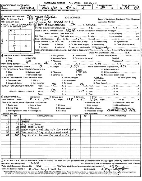
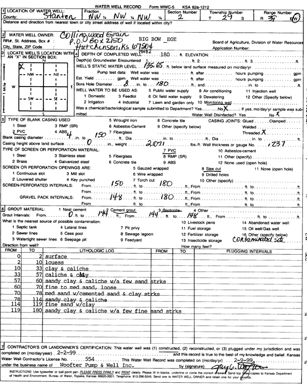
T29S, R39W, Sec. 2 NW NW NW |
Collingwood Grain, Inc. | 171 ft. | 137.74 ft. | Monitoring well/observation/piezometer | MW 4 | Constructed | 03-Feb-1999 | Scan | |
|
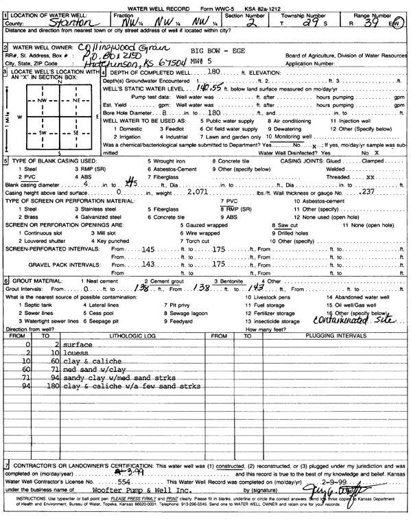
T29S, R39W, Sec. 2 NW NW NW |
Collingwood Grain, Inc. | 180 ft. | 140.5 ft. | Monitoring well/observation/piezometer | MW 5 | Constructed | 03-Feb-1999 | Scan | |
|
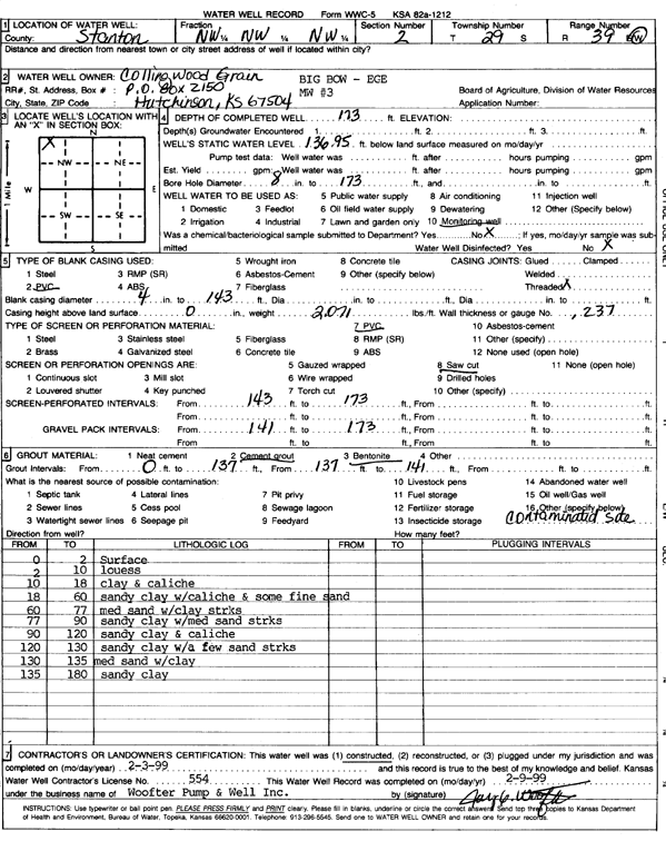
T29S, R39W, Sec. 2 NW NW NW |
Collingwood Grain, Inc. | 173 ft. | 136.95 ft. | Monitoring well/observation/piezometer | MW 3 | Constructed | 03-Feb-1999 | Scan | |
|
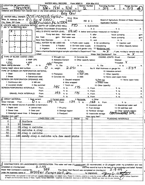
T29S, R39W, Sec. 2 NW NW NW |
Collingwood Grain, Inc. | 175 ft. | 119.6 ft. | Monitoring well/observation/piezometer | MW 1 | Constructed | 01-Feb-1999 | Scan | |
|
T29S, R39W, Sec. 2 NW NW NW |
Collingwood Grain, Inc. | 180 ft. | 135.6 ft. | Monitoring well/observation/piezometer | MW 2 | Constructed | 02-Feb-1999 | Scan | |
|
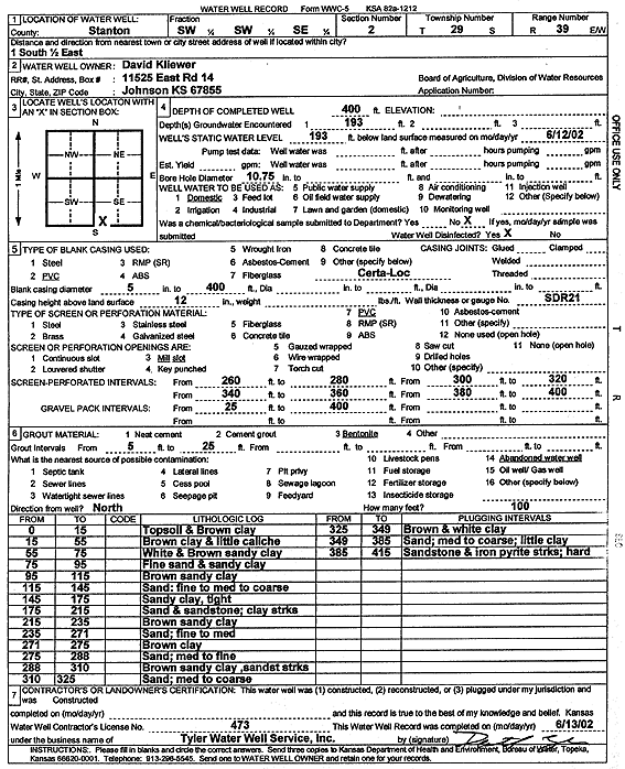
T29S, R39W, Sec. 2 SW SW SE |
Kliewer, David | 400 ft. | 193 ft. | Domestic | Constructed | 13-Jun-2002 | Scan | ||
|
T29S, R39W, Sec. 2 NE SW NE |
Lynlo Land Corp. | 455 ft. | 202 ft. | 1300 gpm. | Irrigation | Constructed | 24-May-1976 | ||
|
T29S, R39W, Sec. 2 NW NE NE NE |
Nelson, Wesley C. and Sharon M. | 647 ft. | 362 ft. | 522 gpm. | Irrigation | Constructed | 30-Jul-2013 |
KOLAR |
|
|
T29S, R39W, Sec. 3 SW SW NE |
Cornett, B.F. | 500 ft. | 230 ft. | Irrigation | Plugged | 30-Nov-1990 | |||
|
T29S, R39W, Sec. 3 SE SE NE |
Cornett, B.F. | 548 ft. | 230 ft. | 1200 gpm. | Irrigation | Plugged | 25-Oct-2005 | ||
|
T29S, R39W, Sec. 3 SE SE NE |
Cornett, B.F. | 548 ft. | 230 ft. | 1200 gpm. | Irrigation | Reconstructed | 19-Jul-1990 | ||
|
T29S, R39W, Sec. 3 NW NE NE |
Cornett, B.F. | 460 ft. | 240 ft. | Irrigation | Plugged | 08-Nov-1990 | |||
|
T29S, R39W, Sec. 3 SE NW SE |
Cornett, B.F. | 526 ft. | Irrigation | Constructed | 15-Apr-1987 | ||||
|
T29S, R39W, Sec. 3 NW NW NE |
Cornett, B.F. | 570 ft. | 190 ft. | 850 gpm. | Irrigation | Constructed | 15-Apr-1977 | ||
|
T29S, R39W, Sec. 3 SE SE NE |
Cornett, Viola | 477 ft. | 242 ft. | Irrigation | Constructed | 04-Oct-2000 | Scan | ||
|
T29S, R39W, Sec. 3 SE NE NE NE |
Garcia, Refulio | 480 ft. | 360 ft. | 15 gpm. | Domestic | Constructed | 05-Jun-2020 | ||
|
T29S, R39W, Sec. 3 NW SW SW NW |
Image Farms | 460 ft. | 324 ft. | Irrigation | Constructed | 01-Jun-2011 | |||
|
T29S, R39W, Sec. 5 SW SW SW |
Kilgore, Leon | 475 ft. | 186 ft. | 1800 gpm. | Irrigation | Constructed | 10-Mar-1975 | ||
|
T29S, R39W, Sec. 5 SW SE SW |
Kilgore, Leon | 340 ft. | 160 ft. | 15 gpm. | Domestic | Constructed | 27-Jan-1977 | ||
|
T29S, R39W, Sec. 6 NW |
EMJ Farms Inc. | 393 ft. | 325 ft. | Irrigation | Plugged | 28-Mar-2008 | |||
|
T29S, R39W, Sec. 6 NW NW |
EMJ Farms Inc. | 561 ft. | 309 ft. | Irrigation | and 3351 | Constructed | 20-Nov-2007 | ||
|
T29S, R39W, Sec. 6 NW SW SW |
Nairin and Nairin Farms | 600 ft. | 413 ft. | 25 gpm. | Domestic | Constructed | 21-Mar-2025 |
KOLAR |
|
|
T29S, R39W, Sec. 6 SW NW NE |
Nairn and Nairn Farms | 630 ft. | 378 ft. | 650 gpm. | Irrigation | Constructed | 22-Mar-2023 |
KOLAR |
|
|
T29S, R39W, Sec. 6 NE SW SW |
Nairn and Nairn Farms | 630 ft. | 386 ft. | 550 gpm. | Irrigation | Constructed | 15-Mar-2023 |
KOLAR |
|
|
T29S, R39W, Sec. 7 NE SW SE |
Oxy USA, Inc. | 380 ft. | 237 ft. | 100 gpm. | Oil Field Water Supply | Henry A 1 | Constructed | 20-Oct-2010 | |
|
T29S, R39W, Sec. 8 C SE SW |
Trans-Pacific Oil Corp. | 360 ft. | 250 ft. | 85 gpm. | Oil Field Water Supply | Powell 1-8 | Constructed | 16-Jul-1992 | |
|
T29S, R39W, Sec. 9 SE SE SE |
Dotzor Trust | 223 ft. | Irrigation | Plugged | 29-Mar-1988 | ||||
|
T29S, R39W, Sec. 10 NW SW SW |
Dotzor Trust | 141 ft. | Irrigation | Plugged | 29-Mar-1988 | ||||
|
T29S, R39W, Sec. 10 NE NE SW |
McPherson College | 465 ft. | 300 ft. | Irrigation | Constructed | 21-Jul-2000 | Scan | ||
|
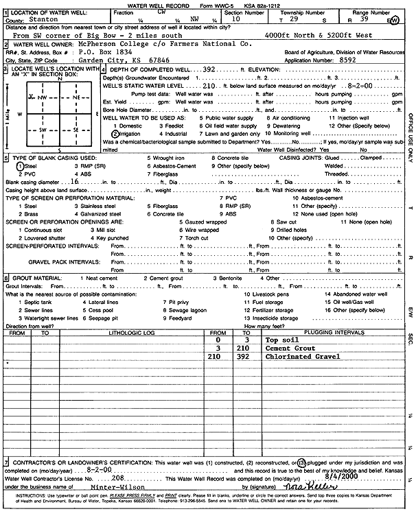
T29S, R39W, Sec. 10 C W2 NW |
McPherson College | 392 ft. | 210 ft. | Irrigation | Plugged | 02-Aug-2000 | Scan | ||
|
T29S, R39W, Sec. 11 SE NE |
Bell, Douglas F. | 475 ft. | 360 ft. | Irrigation | Plugged | 16-Dec-2013 | |||
|
T29S, R39W, Sec. 11 SE SE NE |
Saw Farming | 611 ft. | 368 ft. | Irrigation | 2-24 | Constructed | 29-Jun-2024 |
KOLAR |
|
|
T29S, R39W, Sec. 12 NE SW NE |
Lorlovick, Don | 562 ft. | 175 ft. | 1200 gpm. | Irrigation | Constructed | 27-Dec-1976 | ||
|
T29S, R39W, Sec. 12 SE SW SW NE |
Nelson, Seth and Jodi | 602 ft. | 350 ft. | 250 gpm. | Irrigation | Constructed | 15-Jun-2015 |
KOLAR |
|
|
T29S, R39W, Sec. 13 SE SE NE |
Mahle, William | 561.1 ft. | 260 ft. | 1400 gpm. | Irrigation | Constructed | 15-Sep-1976 | ||
|
T29S, R39W, Sec. 14 NW NW SE |
Byer, Joe | 554 ft. | 144 ft. | 1000 gpm. | Irrigation | Constructed | 17-Apr-1976 | ||
|
T29S, R39W, Sec. 14 C N2 NW |
Jones, Roger | 340 ft. | 160 ft. | Domestic | Constructed | 24-Apr-1991 | |||
|
T29S, R39W, Sec. 15 SW NW SW NW |
Charles Garey Trust and K.U. Endowment Assoc. | 579 ft. | 314 ft. | 772 gpm. | Irrigation | Constructed | 15-Nov-2013 |
KOLAR |
|
| View page: < Prev || 11 || 12 || 13 || 14 || 15 || 16 || 17 || 18 || 19 || 20 || Next > | |||||||||