Select location of well to view details.
Click on column heading to sort.
|
|
|
County: Stanton Select location of well to view details. Click on column heading to sort. |
|
|
|
| View page: < Prev || 11 || 12 || 13 || 14 || 15 || 16 || 17 || 18 || 19 || 20 || Next > | |||||||||
| T-R-S | Owner | Well Depth Ascend. Desc. |
Static Water Level Ascend. Desc. |
Est. Yield Ascend. Desc. |
Well Use | Other ID | Action Taken | Completion Date Ascend. Desc. |
Scan? |
|
T29S, R40W, Sec. 35 SW NW NE |
Amoco Oil Co. | 400 ft. | 220 ft. | 75 gpm. | Oil Field Water Supply | Constructed | 31-Jan-1996 | ||
|
T29S, R40W, Sec. 35 C SE SW |
Amoco Oil Co. | 390 ft. | 260 ft. | 100 gpm. | Oil Field Water Supply | Mitchell Greta 1-35 | Constructed | 20-Mar-1996 | |
|
T29S, R40W, Sec. 35 SE SE SE SE |
Hay Hook Ag | 560 ft. | 378 ft. | 20 gpm. | Domestic, Livestock | Constructed | 14-Dec-2021 | ||
|
T29S, R40W, Sec. 35 SW SW NE |
Hay Hook Farms | 380 ft. | 200 ft. | Domestic | Constructed | 13-Jan-1981 | |||
|
T29S, R40W, Sec. 35 SE SE SE |
Hay Hook Farms | 400 ft. | 180 ft. | Domestic | Constructed | 15-Jan-1981 | |||
|
T29S, R40W, Sec. 35 NE NE SE |
Martin, Wylie | 590 ft. | 318 ft. | Irrigation | Constructed | 26-Aug-2008 | |||
|
T29S, R41W, Sec. 1 SW SW SE |
Arnold, Richard | 438 ft. | Irrigation | Plugged | 01-Jul-2008 | ||||
|
T29S, R41W, Sec. 1 SW SW SW |
J.M. Huber Corp. | 420 ft. | 210 ft. | 60 gpm. | Oil Field Water Supply | Richard Arnold 1-1 | Constructed | 23-Jan-1997 | |
|
T29S, R41W, Sec. 1 SW SW SW |
J.M. Huber Corp. | 420 ft. | 210 ft. | Oil Field Water Supply | Richard Arnold 1-1 | Plugged | 05-Sep-1997 | ||
|
T29S, R41W, Sec. 2 SE SE SE |
Arnold, Richard | 550 ft. | 327 ft. | Irrigation | Constructed | 16-Jul-1996 | |||
|
T29S, R41W, Sec. 3 NW NW SE NE |
Mendoza, Arnoldo | 480 ft. | 327 ft. | 15 gpm. | Domestic, Livestock | Constructed | 05-Aug-2019 | ||
|
T29S, R41W, Sec. 3 NE NE NE |
Rios, Joe | 404 ft. | 327 ft. | 50 gpm. | Domestic | Constructed | 20-Jul-1998 | ||
|
T29S, R41W, Sec. 3 NE NE NE |
Roth, Marc | 413 ft. | 320 ft. | 30 gpm. | Domestic | Constructed | 16-Aug-1994 | ||
|
T29S, R41W, Sec. 3 NE NW NW |
Smith, Frank | 412 ft. | 264 ft. | 500 gpm. | Irrigation | Constructed | 23-Jul-1975 | ||
|
T29S, R41W, Sec. 4 SE SE SW |
Kirkland, Lloyd | 403 ft. | 260 ft. | Domestic | Constructed | 17-Apr-1985 | |||
|
T29S, R41W, Sec. 4 SW SW SE |
Lewis, Doyle | 397 ft. | 260 ft. | 30 gpm. | Domestic | Constructed | 31-Dec-1985 | ||
|
T29S, R41W, Sec. 4 NE NE SE SW |
Tucker, Wade | 440 ft. | 246 ft. | 50 gpm. | Domestic, Livestock | Constructed | 28-Feb-2020 | ||
|
T29S, R41W, Sec. 6 NW SE NE |
J.M. Huber Corp. | 340 ft. | 230 ft. | 100 gpm. | Oil Field Water Supply | Dorr 6-1 | Constructed | 29-Nov-1994 | |
|
T29S, R41W, Sec. 7 SE SE NE |
Davidson, Lyle, Sr. | 387.6 ft. | 220 ft. | 1200 gpm. | Irrigation | Constructed | 25-Jun-1980 | ||
|
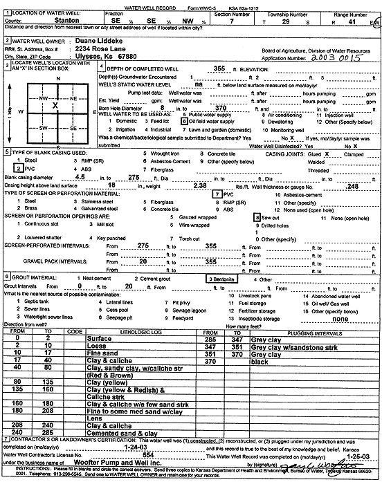
T29S, R41W, Sec. 7 SE SE NW |
Liddeke, Duane | 355 ft. | Oil Field Water Supply | Constructed | 24-Jan-2003 | Scan | |||
|
T29S, R41W, Sec. 9 NW NW NW |
Householder, Wendell | 440 ft. | Domestic | Constructed | 30-Mar-2011 | ||||
|
T29S, R41W, Sec. 10 W2 SE NW |
H & L Operating | 460 ft. | 320 ft. | 90 gpm. | Oil Field Water Supply | Powell 1-10 | Constructed | 04-Sep-1995 | |
|
T29S, R41W, Sec. 11 SE SE SE |
Arnold, Glenn | 500 ft. | 260 ft. | 60 gpm. | Domestic | Constructed | 12-Jul-1977 | ||
|
T29S, R41W, Sec. 11 SW SW SW |
J.M. Huber Corp. | 440 ft. | 260 ft. | 100 gpm. | Oil Field Water Supply | Ruby Arnold 11-3 | Constructed | 17-Sep-1996 | |
|
T29S, R41W, Sec. 11 SW SW SW |
J.M. Huber Corp. | 440 ft. | 260 ft. | Oil Field Water Supply | Ruby Arnold 11-3 | Plugged | 05-Sep-1997 | ||
|
T29S, R41W, Sec. 11 NW NW NW |
Murfin Drilling/Glen and Ruby Arnold | 380 ft. | 50 ft. | Oil Field Water Supply | Plugged | 03-Jan-1994 | |||
|
T29S, R41W, Sec. 11 NW NW NW |
Murfin Drilling/Glen and Ruby Arnold | 380 ft. | 290 ft. | Oil Field Water Supply | Constructed | 03-Dec-1993 | |||
|
T29S, R41W, Sec. 12 NW NW NE |
Arnold, Earl | 520 ft. | Oil Field Water Supply | Constructed | 13-Aug-1996 | ||||
|
T29S, R41W, Sec. 12 N SE SW NW |
Arnold, Earl | 443 ft. | Irrigation | Plugged | 01-Jul-2008 | ||||
|
T29S, R41W, Sec. 12 SW SE SW |
Arnold, Earl | 485 ft. | 179 ft. | 50 gpm. | Domestic | Constructed | 02-May-1997 | ||
|
T29S, R41W, Sec. 12 SE SE NE |
J.M. Huber Corp. | 460 ft. | 305 ft. | 75 gpm. | Oil Field Water Supply | Arnold 12-3 | Constructed | 30-Sep-1994 | |
|
T29S, R41W, Sec. 12 SE SE NE |
J.M. Huber Corp. | 460 ft. | 305 ft. | Oil Field Water Supply | Arnold 12-3 | Plugged | 15-Nov-1994 | ||
|
T29S, R41W, Sec. 12 NW NE NW |
Murfin Drilling/Richard Arnold | 360 ft. | 285 ft. | Oil Field Water Supply | Constructed | 28-Mar-1994 | |||
|
T29S, R41W, Sec. 13 SW SW SW NE |
Bell, Souglas F & Renell M | 644 ft. | 336 ft. | 250 gpm. | Irrigation | Constructed | 06-Apr-2016 |
KOLAR |
|
|
T29S, R41W, Sec. 13 SW NW SW |
J.M. Huber Corp. | 460 ft. | 210 ft. | 90 gpm. | Oil Field Water Supply | Richard Arnold 13-1 | Constructed | 19-Oct-1994 | |
|
T29S, R41W, Sec. 13 SW NW SW |
J.M. Huber Corp. | 460 ft. | 210 ft. | Oil Field Water Supply | Richard Arnold 13-1 | Plugged | 15-Nov-1994 | ||
|
T29S, R41W, Sec. 13 NE NE NE |
Jones, Carl | 450 ft. | 260 ft. | 35 gpm. | Domestic | Constructed | 22-May-1978 | ||
|
T29S, R41W, Sec. 14 SW SE SW |
Kendrick, Gary | 585 ft. | 245.5 ft. | Irrigation | Constructed | 14-Jun-1994 | |||
|
T29S, R41W, Sec. 14 C NE |
Webber Supply | 640 ft. | 280 ft. | 60 gpm. | Oil Field Water Supply | Brett Kendrick | Constructed | 12-Apr-1995 | |
|
T29S, R41W, Sec. 15 NW NE NE |
Cheyenne Drilling | 420 ft. | 250 ft. | 75 gpm. | Oil Field Water Supply | Kendrick 15-1 | Constructed | 23-Aug-1993 | |
|
T29S, R41W, Sec. 15 NW NE NE |
Cheyenne Drilling | 410 ft. | 250 ft. | Oil Field Water Supply | Kendrick 15-1 | Plugged | 06-Apr-1995 | ||
|
T29S, R41W, Sec. 15 NE NE NW |
Tucker, Wendell L. | 630 ft. | 200 ft. | 1100 gpm. | Irrigation | Constructed | 11-Jul-1977 | ||
|
T29S, R41W, Sec. 16 NE NE NE |
Murfin Drilling Co. | 400 ft. | 230 ft. | 75 gpm. | Oil Field Water Supply | Fretz 16-1 | Constructed | 13-Feb-1992 | |
|
T29S, R41W, Sec. 16 NE NE NE |
Murfin Drilling Co. | 400 ft. | 230 ft. | Oil Field Water Supply | Fretz 16-1 | Plugged | 24-Mar-1993 | ||
|
T29S, R41W, Sec. 20 SE SW SE |
Haney, William F. | 381 ft. | 120 ft. | 15 gpm. | Domestic | Constructed | 29-Jul-1977 | ||
|
T29S, R41W, Sec. 21 NE SE NE |
H-40 Drilling | 300 ft. | 200 ft. | 95 gpm. | Oil Field Water Supply | G. Scott 21-1 | Constructed | 24-Feb-1993 | |
|
T29S, R41W, Sec. 22 NE NE NE |
Smith, Frank | 401 ft. | 230 ft. | 1000 gpm. | Irrigation | Constructed | 09-Aug-1975 | ||
|
T29S, R41W, Sec. 23 SW SW SE |
Walker, Kim | 507 ft. | 274 ft. | 30 gpm. | Domestic | Constructed | 13-Dec-1997 | ||
|
T29S, R41W, Sec. 25 NW NW NW |
Cockreham, Herman | 290 ft. | 220 ft. | 30 gpm. | Domestic | Constructed | 12-Jun-1978 | ||
|
T29S, R41W, Sec. 25 NW NW NW |
Fiss, Vernon | 413 ft. | 262 ft. | 20 gpm. | Domestic | Constructed | 05-Oct-1995 | ||
| View page: < Prev || 11 || 12 || 13 || 14 || 15 || 16 || 17 || 18 || 19 || 20 || Next > | |||||||||