Select location of well to view details.
Click on column heading to sort.
|
|
|
County: Stanton Select location of well to view details. Click on column heading to sort. |
|
|
|
| View page: 1 || 2 || 3 || 4 || 5 || 6 || 7 || 8 || 9 || 10 || Next > | |||||||||
| T-R-S | Owner | Well Depth Ascend. Desc. |
Static Water Level Ascend. Desc. |
Est. Yield Ascend. Desc. |
Well Use | Other ID | Action Taken | Completion Date Ascend. Desc. |
Scan? |
|
T28S, R41W, Sec. 1 SE SE SE |
Cross and Nichols | 577 ft. | 151 ft. | 1000 gpm. | Irrigation | Constructed | 05-Sep-1980 | ||
|
T28S, R41W, Sec. 1 NW NE NE |
Cross and Nichols | 589 ft. | 234 ft. | Monitoring well/observation/piezometer | Constructed | 10-Jan-1998 | |||
|
T28S, R41W, Sec. 1 NW NE NE |
Cross and Nichols | 589 ft. | 234 ft. | Irrigation | Constructed | 08-Jan-1998 | |||
|
T28S, R41W, Sec. 1 SW SW SE |
Dimmitt, J.W. | 290 ft. | 85 ft. | 40 gpm. | Domestic | Constructed | 10-Apr-1980 | ||
|
T28S, R41W, Sec. 1 SW NE NE |
Five-N Feeders | 635 ft. | 235 ft. | Irrigation | Constructed | 24-Oct-2003 | Scan | ||
|
T28S, R41W, Sec. 1 SE SE NE |
Five-N Feeders | 577 ft. | 213 ft. | 60 gpm. | Domestic | Constructed | 01-Jun-2000 | Scan | |
|
T28S, R41W, Sec. 2 NW SW SW |
Canny, Lester | 280 ft. | 192 ft. | Domestic | Constructed | 19-Aug-1982 | |||
|
T28S, R41W, Sec. 2 SW SW NW |
Seger, Robert | 340 ft. | 270 ft. | Domestic | Constructed | 06-Oct-1975 | |||
|
T28S, R41W, Sec. 2 SE SW SW |
Wilkerson, Bryce | 614 ft. | 298 ft. | Irrigation | Constructed | 04-Mar-2026 |
KOLAR |
||
|
T28S, R41W, Sec. 5 SW SW NW |
Cockrum, Leroy | 635 ft. | 205 ft. | 1326 gpm. | Irrigation | Constructed | 18-Mar-1975 | ||
|
T28S, R41W, Sec. 5 SW SE SE |
Triple L Farms | 340 ft. | 261 ft. | Irrigation | Constructed | 06-Jun-1994 | |||
|
T28S, R41W, Sec. 6 NW NW SE |
Lawhead, Charles | 350 ft. | 285 ft. | Irrigation | Constructed | 22-Nov-1999 | Scan | ||
|
T28S, R41W, Sec. 6 NW NW NE |
Peterson, Mrs. Charles | 376 ft. | 291 ft. | Irrigation | Constructed | 26-Apr-2003 | Scan | ||
|
T28S, R41W, Sec. 6 W2 NW |
Roach, Dave | 387 ft. | 223 ft. | 1466 gpm. | Irrigation | Constructed | 09-Dec-1976 | ||
|
T28S, R41W, Sec. 6 SW SW SW |
Roach, David | 628 ft. | 287 ft. | Irrigation | Plugged | 24-Dec-1999 | Scan | ||
|
T28S, R41W, Sec. 8 NW NW SW |
Cockrum, Leroy | 554 ft. | 238 ft. | 950 gpm. | Irrigation | Constructed | 25-Sep-1979 | ||
|
T28S, R41W, Sec. 11 SW SE NE |
Canny, Roger | 525 ft. | 306 ft. | 25 gpm. | Domestic | Constructed | 17-Sep-1998 | Scan | |
|
T28S, R41W, Sec. 11 SE SW SE NW |
Canny, Roger | 540 ft. | 318 ft. | 30 gpm. | Domestic, Livestock | Constructed | 01-Aug-2019 | ||
|
T28S, R41W, Sec. 14 SW SW SW |
City of Johnson | 340 ft. | 160 ft. | Other | Constructed | 07-Oct-1975 | |||
|
T28S, R41W, Sec. 15 NE NW SE |
Seyb, Bill | 375 ft. | 224 ft. | Domestic, Livestock | Constructed | 12-Oct-1980 | |||
|
T28S, R41W, Sec. 16 NE SE SW |
Canny, Lester | 348 ft. | 220 ft. | 1435 gpm. | Irrigation | Constructed | 14-Nov-1975 | ||
|
T28S, R41W, Sec. 17 SE SE SW |
Canny Farms | 621 ft. | 267 ft. | Irrigation | Constructed | 04-Sep-1999 | Scan | ||
|
T28S, R41W, Sec. 19 SE SW SE |
Nairn, Arch | 378 ft. | 235 ft. | 1150 gpm. | Irrigation | Constructed | 23-Sep-1997 | ||
|
T28S, R41W, Sec. 20 NE NE SE |
Cockrum, Olie | 505 ft. | Irrigation | Constructed | 20-Apr-1976 | ||||
|
T28S, R41W, Sec. 20 NW NW SE |
Nairn Land LLC | 387 ft. | 259 ft. | Irrigation | Constructed | 30-May-2011 | |||
|
T28S, R41W, Sec. 20 NW NW SE |
Nairn, Archie | 643 ft. | 252 ft. | 636 gpm. | Irrigation | Constructed | 03-Jun-1998 | ||
|
T28S, R41W, Sec. 21 SW SW SW SW |
Dominguez, Hector | 615 ft. | 302 ft. | 25 gpm. | Domestic, Livestock | Constructed | 02-Apr-2019 |
KOLAR |
|
|
T28S, R41W, Sec. 21 C SE |
Dorsey, J.H. | 348 ft. | 225 ft. | 1200 gpm. | Irrigation | Constructed | 17-May-1975 | ||
|
T28S, R41W, Sec. 23 NW NW SW |
Canny Farms | 624 ft. | 372 ft. | Irrigation | Constructed | 30-Mar-2000 | Scan | ||
|
T28S, R41W, Sec. 23 SW NE SE |
Canny, Lester | 360 ft. | 270 ft. | 25 gpm. | Domestic | Constructed | 01-Jul-1979 | ||
|
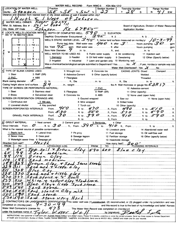
T28S, R41W, Sec. 23 SE SE SW |
Canny, Roger | 590 ft. | 345 ft. | 45 gpm. | Domestic | Constructed | 30-Sep-1999 | Scan | |
|
T28S, R41W, Sec. 23 SE NE NW |
Stanton County Landfill | 589 ft. | 346 ft. | Domestic | Constructed | 13-Mar-2003 | Scan | ||
|
T28S, R41W, Sec. 24 SW SW SW |
Brady, Robert | 360 ft. | 190 ft. | Domestic | Constructed | 13-Jan-1981 | |||
|
T28S, R41W, Sec. 24 C NW |
Dimitt, Jim | 380 ft. | 231 ft. | 1200 gpm. | Irrigation | Constructed | 15-Apr-1975 | ||
|
T28S, R41W, Sec. 24 NE NE SW |
KU Endowment Association | 632 ft. | 331 ft. | Irrigation | Constructed | 16-Dec-2000 | Scan | ||
|
T28S, R41W, Sec. 24 SE SE NE |
Winger, Melvin | 614 ft. | 330 ft. | Irrigation | Constructed | 14-Jun-2002 | Scan | ||
|
T28S, R41W, Sec. 25 NE SW NE |
Beredco Inc. | 430 ft. | 290 ft. | 120 gpm. | Oil Field Water Supply | Roberts 1 | Constructed | 29-Nov-1996 | |
|
T28S, R41W, Sec. 25 C NE SW |
Premier Farms | 613 ft. | 346 ft. | 1120 gpm. | Irrigation | Constructed | 17-Apr-1998 | ||
|
T28S, R41W, Sec. 26 SE SE NW |
J.M. Huber Corp. | 460 ft. | 272 ft. | 120 gpm. | Oil Field Water Supply | Nairn 26-2 | Constructed | 17-May-1995 | |
|
T28S, R41W, Sec. 26 C NE |
Nairn, Archie | 343 ft. | 325 ft. | Irrigation | Plugged | 10-Sep-1992 | |||
|
T28S, R41W, Sec. 26 C NE |
Nairn, Archie L. | 625 ft. | 327 ft. | Irrigation | Constructed | 23-Jun-1992 | |||
|
T28S, R41W, Sec. 28 SW SE NW |
Brown, Hugh | 380 ft. | 310 ft. | 25 gpm. | Domestic | Constructed | 21-Jun-1994 | ||
|
T28S, R41W, Sec. 28 NW SW SW |
Garrison, Jim | 384 ft. | 311 ft. | 15 gpm. | Domestic | Constructed | 01-Oct-1999 | Scan | |
|
T28S, R41W, Sec. 28 NW SW NE |
McKinney, Letticia Rene | 710 ft. | 345 ft. | 375 gpm. | Irrigation | Constructed | 21-Aug-2024 |
KOLAR |
|
|
T28S, R41W, Sec. 28 SE NE SW |
Pauls, Duane | 420 ft. | 345 ft. | 50 gpm. | Domestic | Constructed | 01-Aug-1994 | ||
|
T28S, R41W, Sec. 29 NW NW NE |
McKinney, Brad | 320.4 ft. | 207 ft. | 735 gpm. | Irrigation | Constructed | 30-Aug-1977 | ||
|
T28S, R41W, Sec. 29 SW SW SW |
McKinney, Marvin | 300 ft. | 230 ft. | 20 gpm. | Domestic | Constructed | 07-Dec-1976 | ||
|
T28S, R41W, Sec. 30 SW SW NE |
McKinney, Marvin | 334 ft. | 180 ft. | 1000 gpm. | Irrigation | Constructed | 02-Apr-1975 | ||
|
T28S, R41W, Sec. 30 SE NE NE |
Newby Family Legacy LLC | 440 ft. | 258 ft. | 40 gpm. | Domestic, Livestock | Constructed | 20-May-2025 |
KOLAR |
|
|
T28S, R41W, Sec. 31 SE NE NE NW |
McKinney, Brad | 365 ft. | 222 ft. | 60 gpm. | Domestic | Constructed | 12-Feb-2016 | ||
| View page: 1 || 2 || 3 || 4 || 5 || 6 || 7 || 8 || 9 || 10 || Next > | |||||||||