Select location of well to view details.
Click on column heading to sort.
|
|
|
County: Stevens Select location of well to view details. Click on column heading to sort. |
|
|
|
| View page: < Prev || 21 || 22 || 23 || 24 || 25 || 26 || 27 || 28 || 29 || 30 || Next > | |||||||||
| T-R-S | Owner | Well Depth Ascend. Desc. |
Static Water Level Ascend. Desc. |
Est. Yield Ascend. Desc. |
Well Use | Other ID | Action Taken | Completion Date Ascend. Desc. |
Scan? |
|
T33S, R37W, Sec. 6 NE SW NE NW |
Mueller, Jay | 400 ft. | 107 ft. | Domestic | Constructed | 25-Aug-2014 | |||
|
T33S, R37W, Sec. 7 NW NW NE |
Leonard, Jerryt | 543 ft. | 140 ft. | 1615 gpm. | Irrigation | Constructed | 12-Mar-1996 | ||
|
T33S, R37W, Sec. 8 C SW SW |
Exxon Mobil Production | 180 ft. | 150 ft. | Oil Field Water Supply | Ratcliff 3-4 | Plugged | 07-Oct-2005 | ||
|
T33S, R37W, Sec. 8 SW NW NE |
McCoy Petroleum/Thomas Schnittker | 360 ft. | 110 ft. | 105 gpm. | Oil Field Water Supply | Ratcliff 1-8 | Constructed | 19-Aug-1988 | |
|
T33S, R37W, Sec. 8 NW SW NW |
Schnittker, Thomas | 555 ft. | 135 ft. | 1780 gpm. | Irrigation | Constructed | 04-Feb-1997 | ||
|
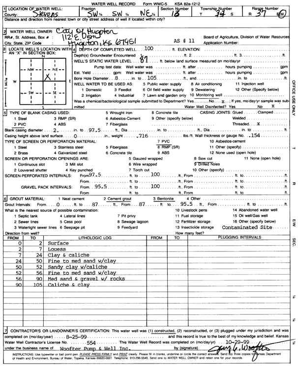
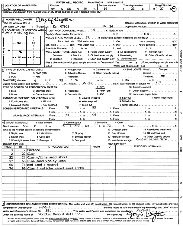
T33S, R37W, Sec. 9 SW NW SE |
City of Hugoton | 540 ft. | 253 ft. | Monitoring well/observation/piezometer | Constructed | 11-Dec-2003 | Scan | ||
|
T33S, R37W, Sec. 9 NW SE SW |
City of Hugoton | 536 ft. | 87 ft. | Public Water Supply | Well 7 | Plugged | 20-Jan-1985 | ||
|
T33S, R37W, Sec. 9 NW NW SE |
City of Hugoton | 544 ft. | 126 ft. | Public Water Supply | Constructed | 29-Dec-2004 | |||
|
T33S, R37W, Sec. 9 SW SW SW |
City of Hugoton | 535 ft. | 97 ft. | 650 gpm. | Public Water Supply | Constructed | 29-Apr-1986 | ||
|
T33S, R37W, Sec. 9 SW SE SE |
City of Hugoton | 562 ft. | 105 ft. | Public Water Supply | Constructed | 14-Apr-1999 | Scan | ||
|
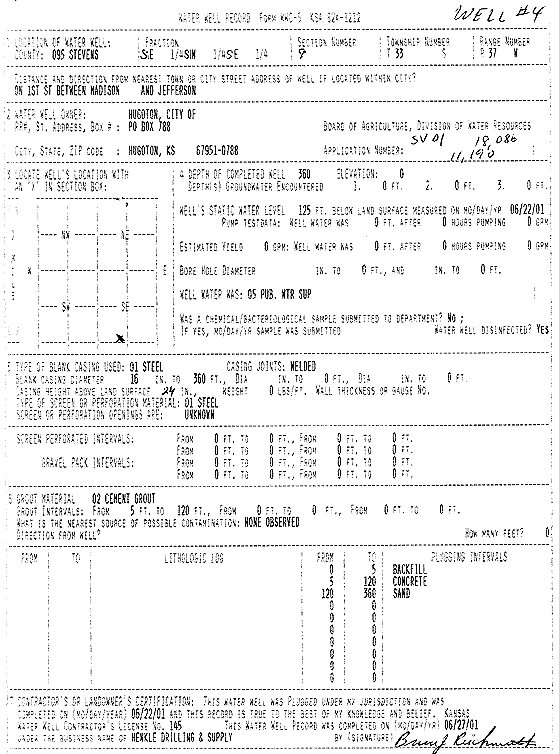
T33S, R37W, Sec. 9 SE SW SE |
City of Hugoton | 360 ft. | 125 ft. | Public Water Supply | Well 4 | Plugged | 22-Jun-2001 | Scan | |
|
T33S, R37W, Sec. 9 W2 W2 SW NW |
Dennis and Elizabeth Moser Farms Trust | 526 ft. | 168 ft. | 1256 gpm. | Irrigation | Constructed | 10-Jul-2012 |
KOLAR |
|
|
T33S, R37W, Sec. 9 SW NW NE |
Hancock Electric | 360 ft. | 100 ft. | 25 gpm. | Domestic | Constructed | 25-Aug-1995 | ||
|
T33S, R37W, Sec. 9 SE NE SW |
Thompson, David | 215 ft. | 150 ft. | (unstated)/abandoned | Plugged | 14-Sep-2004 | |||
|
T33S, R37W, Sec. 10 NE NE NW |
Stevens County | 100 ft. | Monitoring well/observation/piezometer | MW 3 | Constructed | 13-May-1993 | |||
|
T33S, R37W, Sec. 10 NE NE NW |
Stevens County | 93 ft. | Monitoring well/observation/piezometer | MW 4 | Plugged | 25-Jun-2009 | |||
|
T33S, R37W, Sec. 10 NE NE NW |
Stevens County | 93 ft. | Monitoring well/observation/piezometer | MW 1 | Constructed | 11-May-1993 | |||
|
T33S, R37W, Sec. 10 NE NE NW |
Stevens County | 91 ft. | Monitoring well/observation/piezometer | MW 2 | Plugged | 26-Jun-2009 | |||
|
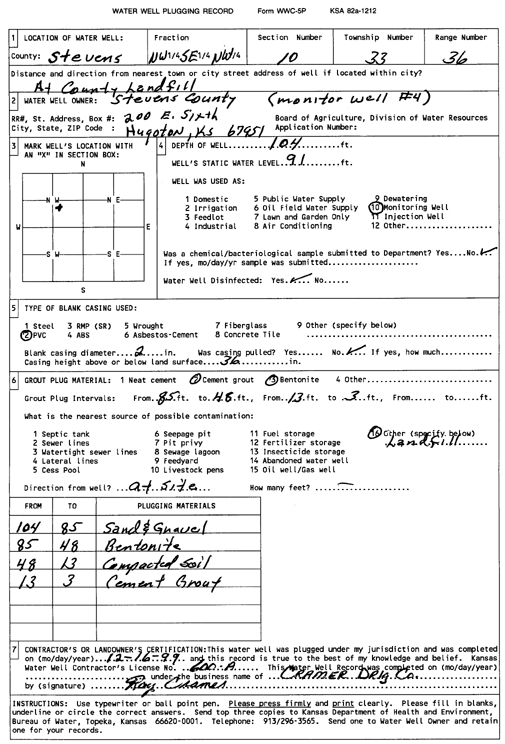
T33S, R37W, Sec. 10 NW SE NW |
Stevens County | 104 ft. | 90 ft. | Monitoring well/observation/piezometer | MW 4 | Constructed | 11-Apr-1994 | ||
|
T33S, R37W, Sec. 10 NE NE NW |
Stevens County | 91 ft. | Monitoring well/observation/piezometer | MW 2 | Constructed | 12-May-1993 | |||
|
T33S, R37W, Sec. 10 NE NE NW |
Stevens County | 180 ft. | 80 ft. | 23 gpm. | Domestic | Constructed | 16-Mar-1979 | ||
|
T33S, R37W, Sec. 10 NW SE NW |
Stevens County | 104 ft. | 91 ft. | Monitoring well/observation/piezometer | MW 4 | Plugged | 16-Dec-1999 | Scan | |
|
T33S, R37W, Sec. 10 SE SE NE NW |
Stevens County Landfill | 130 ft. | 99.1 ft. | Monitoring well/observation/piezometer | MW 3 A | Constructed | 25-Jun-2009 | ||
|
T33S, R37W, Sec. 10 SE NE SE NW |
Stevens County Landfill | 120 ft. | 92.5 ft. | Monitoring well/observation/piezometer | MW 5 A | Constructed | 24-Jun-2009 | ||
|
T33S, R37W, Sec. 10 SE SE SE NW |
Stevens County Landfill | 123.5 ft. | 93.4 ft. | Monitoring well/observation/piezometer | MW 7 A | Constructed | 25-Jun-2009 | ||
|
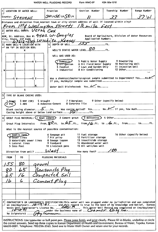
T33S, R37W, Sec. 11 SW SE SE |
Cox, Verna | 155 ft. | 80 ft. | Domestic | Plugged | 09-Oct-2001 | Scan | ||
|
T33S, R37W, Sec. 13 SE SW SE |
Crane, Rob | 360 ft. | 145 ft. | Domestic | Constructed | 17-Feb-2026 |
KOLAR |
||
|
T33S, R37W, Sec. 13 SW SW SE |
Mills, Jeff | 343 ft. | 128 ft. | 50 gpm. | Domestic | Constructed | 04-May-2015 | ||
|
T33S, R37W, Sec. 13 SE SE NE |
Sarchet, Jeff | 355 ft. | Domestic | Constructed | 23-Apr-2010 | ||||
|
T33S, R37W, Sec. 14 NE NE SE NW |
Culler, Mike | 540 ft. | 91 ft. | 20 gpm. | Domestic | Constructed | 10-Sep-2013 |
KOLAR |
|
|
T33S, R37W, Sec. 14 SW |
Mostrom, Gary | 244 ft. | 97 ft. | Domestic | Constructed | 02-Jul-1983 | |||
|
T33S, R37W, Sec. 14 C NW |
Thompson, E.E. | 240 ft. | 85 ft. | 50 gpm. | Domestic | Constructed | 28-Oct-1986 | ||
|
T33S, R37W, Sec. 15 NE NE SW |
Cox, Ber and Virgil | 220 ft. | 83 ft. | 200 gpm. | Domestic | Constructed | 01-Aug-1975 | ||
|
T33S, R37W, Sec. 15 SW SW SW SW |
Frontier Fuel | 150.5 ft. | 117.26 ft. | Monitoring well/observation/piezometer | MW 7 | Constructed | 03-Mar-2017 | ||
|
T33S, R37W, Sec. 15 SW SW SW SW |
Frontier Fuel | 151 ft. | 118.09 ft. | Monitoring well/observation/piezometer | MW 6 | Constructed | 03-Mar-2017 | ||
|
T33S, R37W, Sec. 15 SW SW SW SW |
Frontier Fuel | 150.1 ft. | 118.61 ft. | Monitoring well/observation/piezometer | MW 6 | Plugged | 16-Aug-2018 | ||
|
T33S, R37W, Sec. 15 SW SW SW SW |
Frontier Fuel | 150.4 ft. | 118.35 ft. | Monitoring well/observation/piezometer | MW 7 | Plugged | 16-Aug-2018 | ||
|
T33S, R37W, Sec. 16 SW NW NW |
ADM Grain | 160 ft. | Monitoring well/observation/piezometer | MW 14 | Constructed | 15-Mar-2010 | |||
|
T33S, R37W, Sec. 16 SW NW NW |
ADM Grain | 160 ft. | Monitoring well/observation/piezometer | MW 12 | Constructed | 15-Mar-2010 | |||
|
T33S, R37W, Sec. 16 NW NW NW |
ADM Grain | 170 ft. | Monitoring well/observation/piezometer | MW 16 | Constructed | 13-Dec-2011 | |||
|
T33S, R37W, Sec. 16 NW NW NW NW |
ADM Grain | 226 ft. | 175.39 ft. | Monitoring well/observation/piezometer | MW 18 | Constructed | 21-Apr-2017 | ||
|
T33S, R37W, Sec. 16 NW SW NW NW |
ADM Grain | 224 ft. | 176.43 ft. | Monitoring well/observation/piezometer | MW 19 | Constructed | 21-Apr-2017 | ||
|
T33S, R37W, Sec. 16 SW NW NW |
ADM Grain | 170 ft. | Monitoring well/observation/piezometer | MW 15 | Constructed | 13-Dec-2011 | |||
|
T33S, R37W, Sec. 16 SW NW NW |
ADM Grain | 160 ft. | Monitoring well/observation/piezometer | MW 13 | Constructed | 15-Mar-2010 | |||
|
T33S, R37W, Sec. 16 NW NW NW |
ADM Grain | 160 ft. | Monitoring well/observation/piezometer | MW 10 | Constructed | 28-Aug-2008 | |||
|
T33S, R37W, Sec. 16 NW NW NW |
ADM Grain | 160 ft. | Monitoring well/observation/piezometer | MW 11 | Constructed | 28-Aug-2008 | |||
|
T33S, R37W, Sec. 16 NW NW NW NW |
ADM Grain | 224 ft. | 175.16 ft. | Domestic | MW 17 | Constructed | 21-Apr-2017 | ||
|
T33S, R37W, Sec. 16 C NW NW |
City of Hugoton | 260 ft. | 90 ft. | Public Water Supply | Well 5 | Plugged | 10-Jan-1986 | ||
|
T33S, R37W, Sec. 16 SW SW NE |
City of Hugoton | 100 ft. | 87 ft. | Environmental Remediation, Air Sparge | AS 11 | Constructed | 25-Aug-1999 | Scan | |
|
T33S, R37W, Sec. 16 NW NE SW |
City of Hugoton | 95 ft. | 87 ft. | Monitoring well/observation/piezometer | MW 24 | Constructed | 22-Feb-2000 | Scan | |
| View page: < Prev || 21 || 22 || 23 || 24 || 25 || 26 || 27 || 28 || 29 || 30 || Next > | |||||||||