Select location of well to view details.
Click on column heading to sort.
|
|
|
County: Stevens Select location of well to view details. Click on column heading to sort. |
|
|
|
| View page: < Prev || 41 || 42 || 43 || 44 || 45 || 46 || 47 || 48 || 49 || 50 || Next > | |||||||||
| T-R-S | Owner | Well Depth Ascend. Desc. |
Static Water Level Ascend. Desc. |
Est. Yield Ascend. Desc. |
Well Use | Other ID | Action Taken | Completion Date Ascend. Desc. |
Scan? |
|
T34S, R36W, Sec. 36 C W2 SE |
Roehr Partners | 507 ft. | 180 ft. | Irrigation | Plugged | 14-Oct-2005 | |||
|
T34S, R36W, Sec. 36 C NE SE |
Stalcup, Don | 240 ft. | 128 ft. | 75 gpm. | Domestic | Constructed | 12-Apr-1985 | ||
|
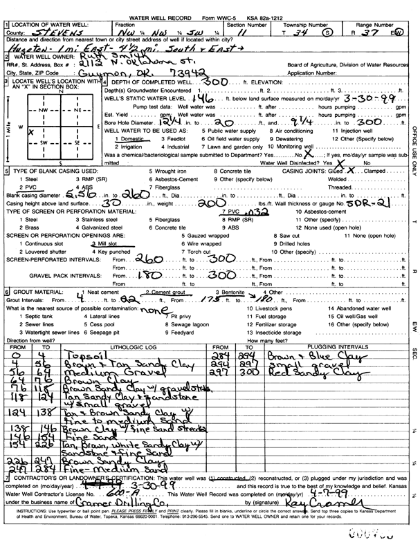
T34S, R37W, Sec. 1 SE SE NE |
Smith, Ruth | 292 ft. | 141 ft. | 50 gpm. | Domestic | Constructed | 25-Sep-2003 | ||
|
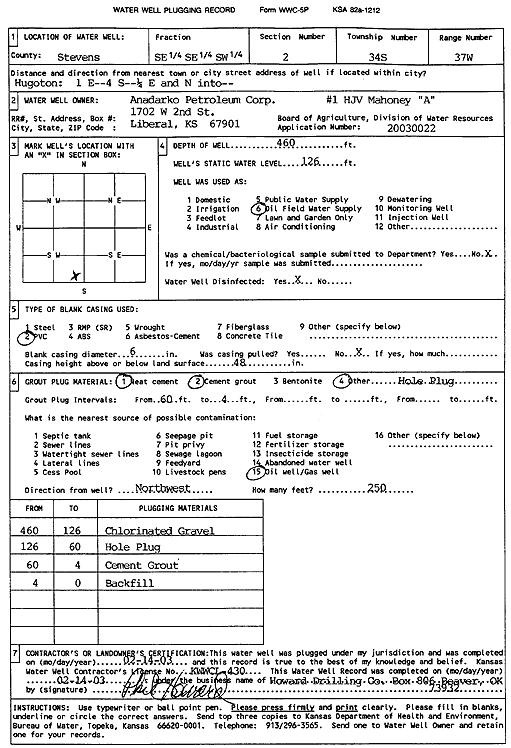
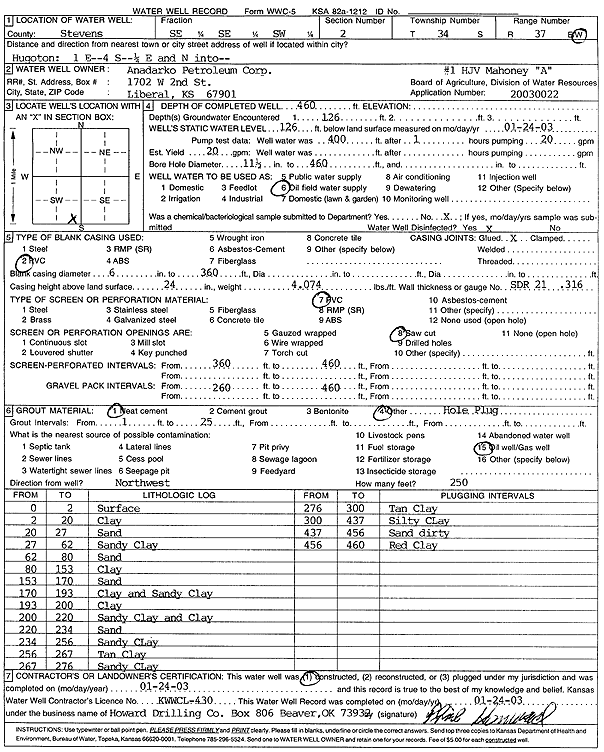
T34S, R37W, Sec. 2 SE SE SW |
Anadarko Petroleum Corp. | 460 ft. | 126 ft. | Oil Field Water Supply | HJV Mahoney A-1 | Plugged | 14-Feb-2003 | Scan | |
|
T34S, R37W, Sec. 2 SE SE SW |
Anadarko Petroleum Corp. | 460 ft. | 126 ft. | 20 gpm. | Oil Field Water Supply | HJV Mahoney A-1 | Constructed | 24-Jan-2003 | Scan |
|
T34S, R37W, Sec. 2 NE NW NW |
Heger, Kirk | 570 ft. | 280 ft. | Irrigation | Plugged | 26-Jan-2012 | |||
|
T34S, R37W, Sec. 2 NE NW |
Heger, Marlin | 595 ft. | 230 ft. | Irrigation | Constructed | 15-Dec-2010 | |||
|
T34S, R37W, Sec. 2 NW SW NE |
Heger, Marlin | 150 ft. | 115 ft. | Domestic, Livestock | Plugged | 01-Apr-1999 | |||
|
T34S, R37W, Sec. 2 NE NE NW |
Heger, Marlin | 578 ft. | 130 ft. | 650 gpm. | Irrigation | Constructed | 17-Jul-1996 | ||
|
T34S, R37W, Sec. 3 SE SW SE |
EOG Resources Inc. | 400 ft. | 200 ft. | 100 gpm. | Oil Field Water Supply | Constructed | 28-May-2006 | ||
|
T34S, R37W, Sec. 3 NE NE NE |
Heger, Marlin | 573 ft. | 119 ft. | Irrigation | Constructed | 06-Feb-1992 | |||
|
T34S, R37W, Sec. 3 SW SW NE |
Heger, Marlin | 601 ft. | 227 ft. | Irrigation | Constructed | 20-Dec-2000 | Scan | ||
|
T34S, R37W, Sec. 4 SW NE NW |
Gabbert and Jones | 270 ft. | 140 ft. | 70 gpm. | Oil Field Water Supply | Natagorda A-1 | Constructed | 22-Jun-1989 | |
|
T34S, R37W, Sec. 4 SW NE NW |
Gabbert and Jones | 270 ft. | 140 ft. | Oil Field Water Supply | Natagorda A-1 | Plugged | 18-Jul-1989 | ||
|
T34S, R37W, Sec. 4 SW SE SW NE |
Gaskill, Dax | 396 ft. | 150 ft. | 10 gpm. | Domestic | Constructed | 16-Nov-2012 |
KOLAR |
|
|
T34S, R37W, Sec. 4 SW SW NE |
Gaskill, Dax | 340 ft. | Domestic | Constructed | 04-Feb-2008 | ||||
|
T34S, R37W, Sec. 4 SW SW SW |
Mostrom, Gary | 601 ft. | 160 ft. | Irrigation | Constructed | 10-Apr-2002 | Scan | ||
|
T34S, R37W, Sec. 4 NW NW NW |
Williby, Gene | 240 ft. | 120 ft. | Domestic | Constructed | 20-Mar-1978 | |||
|
T34S, R37W, Sec. 4 NW NW NW |
Willoughby, Gene | 395 ft. | Domestic | Constructed | 19-Jan-2012 | ||||
|
T34S, R37W, Sec. 5 NW NW NW |
Hoffman Estate | 583 ft. | 144 ft. | 1715 gpm. | Irrigation | Constructed | 17-Jan-1997 | ||
|
T34S, R37W, Sec. 6 NE NE SW |
Anadarko Petroleum Corp. | 260 ft. | 135 ft. | 75 gpm. | Oil Field Water Supply | Kimzey B | Constructed | 08-Jul-1984 | |
|
T34S, R37W, Sec. 6 NE NE SW |
Anadarko Petroleum Corp. | 260 ft. | 135 ft. | Oil Field Water Supply | Kimzey B | Plugged | 31-Jul-1984 | ||
|
T34S, R37W, Sec. 6 NE NE NW |
Kramer, Jim | 255 ft. | 140 ft. | Domestic | Constructed | 20-Apr-1981 | |||
|
T34S, R37W, Sec. 6 SE NE NW |
Pelajo Properties | 560 ft. | 154 ft. | Monitoring well/observation/piezometer | Constructed | 13-Apr-1998 | |||
|
T34S, R37W, Sec. 6 SE NE NW |
Pelajo Properties | 585 ft. | 154 ft. | 2000 gpm. | Irrigation | Constructed | 13-Apr-1998 | ||
|
T34S, R37W, Sec. 6 SE NW NW |
Vyn Land and Cattle | 621 ft. | 258 ft. | 2000 gpm. | Irrigation | Constructed | 13-Jul-2022 |
KOLAR |
|
|
T34S, R37W, Sec. 7 NE NE NE |
Hoffman Estate | 607 ft. | 171 ft. | 2100 gpm. | Irrigation | Constructed | 19-Aug-1997 | ||
|
T34S, R37W, Sec. 8 SW SW NE |
Hoffman Estate | 620 ft. | 166 ft. | 1740 gpm. | Irrigation | Constructed | 04-Mar-1997 | ||
|
T34S, R37W, Sec. 8 SW SW NE |
Hoffman Estate | 589 ft. | 148 ft. | Irrigation | Plugged | 22-Oct-1997 | |||
|
T34S, R37W, Sec. 10 NE SE SW |
Kolb, Brandon | 618 ft. | 242 ft. | Irrigation | Constructed | 06-May-2008 | |||
|
T34S, R37W, Sec. 11 NE NE NW |
Mobil Oil Corp./R.F. Harrison | 340 ft. | 112 ft. | 100 gpm. | Oil Field Water Supply | E.V. Baker 1 | Constructed | 24-May-1986 | |
|
T34S, R37W, Sec. 11 NW NW SW |
Smith, Ruth | 300 ft. | 146 ft. | Domestic | Constructed | 30-Mar-1999 | Scan | ||
|
T34S, R37W, Sec. 12 NW NE SE |
Yoder, Larry | 440 ft. | 205 ft. | Domestic | Constructed | 12-Jul-2006 | |||
|
T34S, R37W, Sec. 13 NW SE SW |
Mostrom, Gary | 680 ft. | 215 ft. | Irrigation | Constructed | 25-Jul-2008 | |||
|
T34S, R37W, Sec. 13 SW |
Mostrom, Gary | 215 ft. | Irrigation | Plugged | 08-Dec-2008 | ||||
|
T34S, R37W, Sec. 13 NW NE SE |
Phifer, John | 660 ft. | 125 ft. | Irrigation | Constructed | 11-Dec-1976 | |||
|
T34S, R37W, Sec. 13 NW NE SE |
Shelton, Mike | 668 ft. | 298 ft. | 1288 gpm. | Irrigation | Constructed | 12-Jun-2024 |
KOLAR |
|
|
T34S, R37W, Sec. 14 NW NW NW |
Berexco Inc. | 380 ft. | 140 ft. | 110 gpm. | Oil Field Water Supply | Deboyler 11-14 | Constructed | 24-Nov-1994 | |
|
T34S, R37W, Sec. 14 SE SE NE |
Gregg, Robert | 340 ft. | 143 ft. | 25 gpm. | Domestic | Constructed | 09-Feb-1977 | ||
|
T34S, R37W, Sec. 14 SE NE NE |
Mostrom, Gary | 650 ft. | 141 ft. | Irrigation | Constructed | 30-Dec-1993 | |||
|
T34S, R37W, Sec. 14 SE NE NE |
Mostrom, Gary and Virginia | 668 ft. | 212 ft. | 400 gpm. | Irrigation | Constructed | 03-May-2023 |
KOLAR |
|
|
T34S, R37W, Sec. 15 SE SE NW |
Clagget, Richard | 608 ft. | 198 ft. | Irrigation | Constructed | 15-Jun-2002 | Scan | ||
|
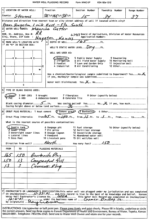
T34S, R37W, Sec. 15 SE NE SE |
Cutter, Maurine | 165 ft. | Domestic | Plugged | 22-Nov-2001 | Scan | |||
|
T34S, R37W, Sec. 17 SE SE NW |
Blakely Trust, Essie | 602 ft. | 175 ft. | Irrigation | Constructed | 27-Jul-1999 | Scan | ||
|
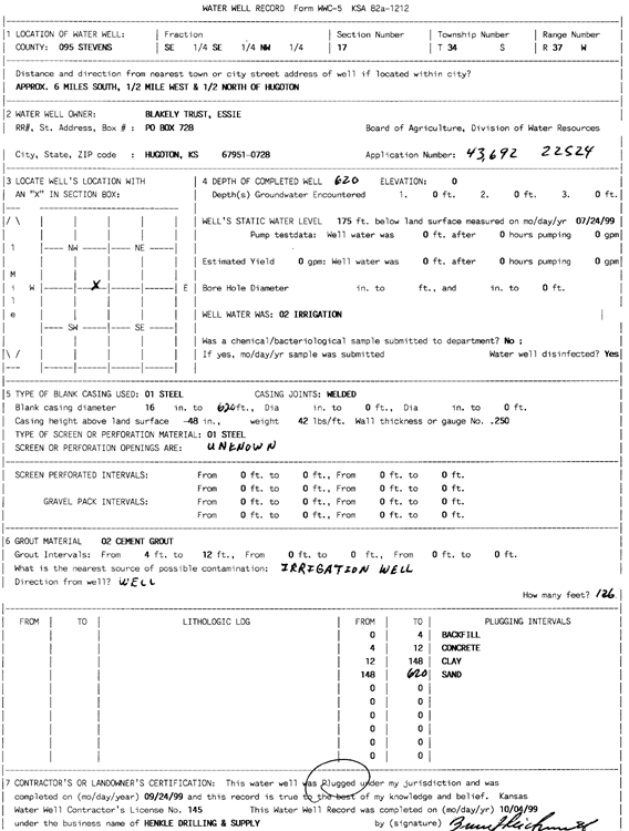
T34S, R37W, Sec. 17 SE SE NW |
Blakely Trust, Essie | 620 ft. | 175 ft. | Irrigation | Plugged | 24-Sep-1999 | Scan | ||
|
T34S, R37W, Sec. 17 NESESW |
CITIZENS BANK | 340 ft. | 113 ft. | Oil Field Water Supply | Constructed | 19-Nov-1996 | |||
|
T34S, R37W, Sec. 17 NESESW |
STATE BANK CITI | 340 ft. | 113 ft. | 90 gpm. | Oil Field Water Supply | Constructed | 19-Nov-1996 | ||
|
T34S, R37W, Sec. 18 C NE SE |
Anadarko Petroleum Corp. | 380 ft. | 184 ft. | Oil Field Water Supply | Spangler A-2 | Plugged | 28-Mar-1998 | ||
|
T34S, R37W, Sec. 18 C NE SE |
Anadarko Petroleum Corp. | 380 ft. | 184 ft. | 100 gpm. | Oil Field Water Supply | Spangler A-2 | Constructed | 18-Oct-1997 | |
|
T34S, R37W, Sec. 18 C SE |
Keefer Farms | 670 ft. | 145 ft. | 1435 gpm. | Irrigation | Constructed | 14-May-1976 | ||
| View page: < Prev || 41 || 42 || 43 || 44 || 45 || 46 || 47 || 48 || 49 || 50 || Next > | |||||||||