Select location of well to view details.
Click on column heading to sort.
|
|
|
County: Thomas Select location of well to view details. Click on column heading to sort. |
|
|
|
| View page: < Prev || 11 || 12 || 13 || 14 || 15 || 16 || 17 || 18 || 19 || 20 || Next > | |||||||||
| T-R-S | Owner | Well Depth Ascend. Desc. |
Static Water Level Ascend. Desc. |
Est. Yield Ascend. Desc. |
Well Use | Other ID | Action Taken | Completion Date Ascend. Desc. |
Scan? |
|
T7S, R33W, Sec. 31 NE SE SW |
Pyramid Oil | 135 ft. | Environmental Remediation, Air Sparge | AS 3 | Plugged | 17-Jul-2008 | |||
|
T7S, R33W, Sec. 31 NE SE SW |
Pyramid Oil | 125 ft. | Monitoring well/observation/piezometer | MW 8 | Plugged | 17-Jul-2008 | |||
|
T7S, R33W, Sec. 31 NE SE SW |
Pyramid Oil | 125 ft. | Monitoring well/observation/piezometer | MW 13 | Plugged | 17-Jul-2008 | |||
|
T7S, R33W, Sec. 31 NE SE SW |
Pyramid Oil | 130 ft. | Environmental Remediation, Air Sparge | AS 2 | Plugged | 17-Jul-2008 | |||
|
T7S, R33W, Sec. 31 NE SE SW |
Pyramid Oil | 125 ft. | Monitoring well/observation/piezometer | MW 16 | Plugged | 17-Jul-2008 | |||
|
T7S, R33W, Sec. 31 NE SE SW |
Pyramid Oil | 100 ft. | Environmental Remediation, Soil Vapor Extraction | SV 4 | Plugged | 11-Jul-2007 | |||
|
T7S, R33W, Sec. 31 NE SE SW |
Pyramid Oil | 130 ft. | Environmental Remediation, Soil Vapor Extraction | SV 3 | Plugged | 17-Jul-2008 | |||
|
T7S, R33W, Sec. 31 NE SE SW |
Pyramid Oil | 50 ft. | Environmental Remediation, Soil Vapor Extraction | SVE 2 | Plugged | 17-Jul-2008 | |||
|
T7S, R33W, Sec. 31 NE SE SW |
Pyramid Oil | 125 ft. | Monitoring well/observation/piezometer | MW 11 | Plugged | 17-Jul-2008 | |||
|
T7S, R33W, Sec. 31 NE SE SW |
Pyramid Oil | 80 ft. | Environmental Remediation, Soil Vapor Extraction | SV 2 | Plugged | 17-Jul-2008 | |||
|
T7S, R33W, Sec. 31 NE SE SW |
Pyramid Oil | 130 ft. | 102.19 ft. | Monitoring well/observation/piezometer | 2 | Constructed | 15-Nov-1995 | ||
|
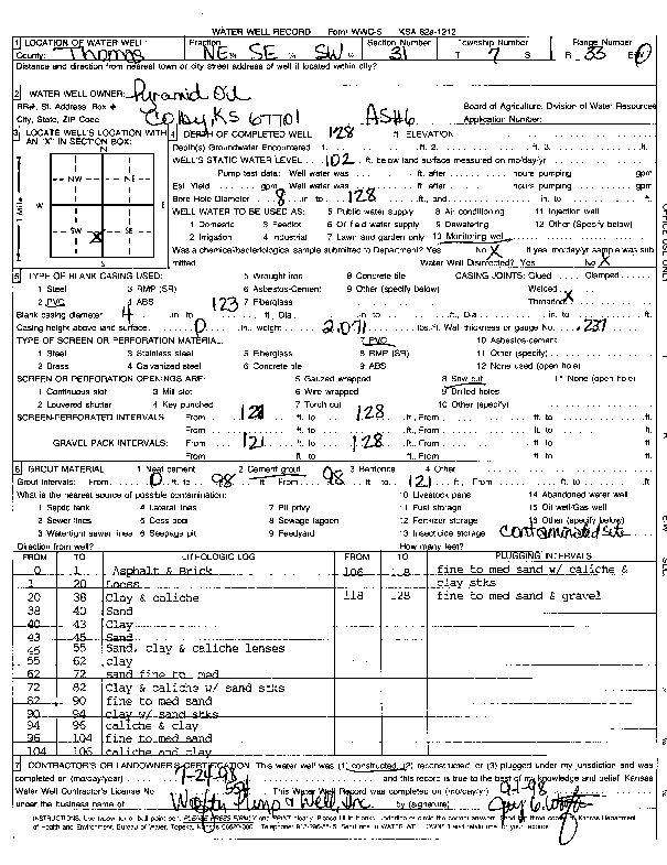
T7S, R33W, Sec. 31 NE SE SW |
Pyramid Oil | 128 ft. | 102 ft. | Environmental Remediation, Air Sparge | AS 6 | Constructed | 24-Jul-1998 | Scan | |
|
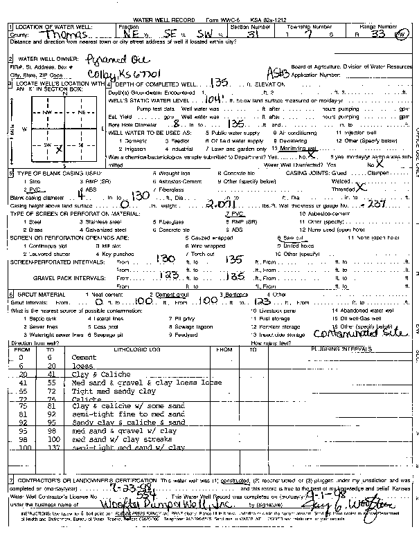
T7S, R33W, Sec. 31 NE SE SW |
Pyramid Oil | 135 ft. | 104 ft. | Environmental Remediation, Air Sparge | AS 3 | Constructed | 23-Jul-1998 | Scan | |
|
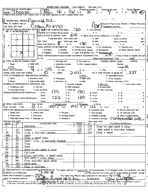
T7S, R33W, Sec. 31 NE SE SW |
Pyramid Oil | 130 ft. | 104 ft. | Environmental Remediation, Air Sparge | AS 7 | Constructed | 24-Jul-1998 | Scan | |
|
T7S, R33W, Sec. 31 NE SE SW |
Pyramid Service | 130 ft. | Monitoring well/observation/piezometer | Constructed | 26-Mar-1996 | ||||
|
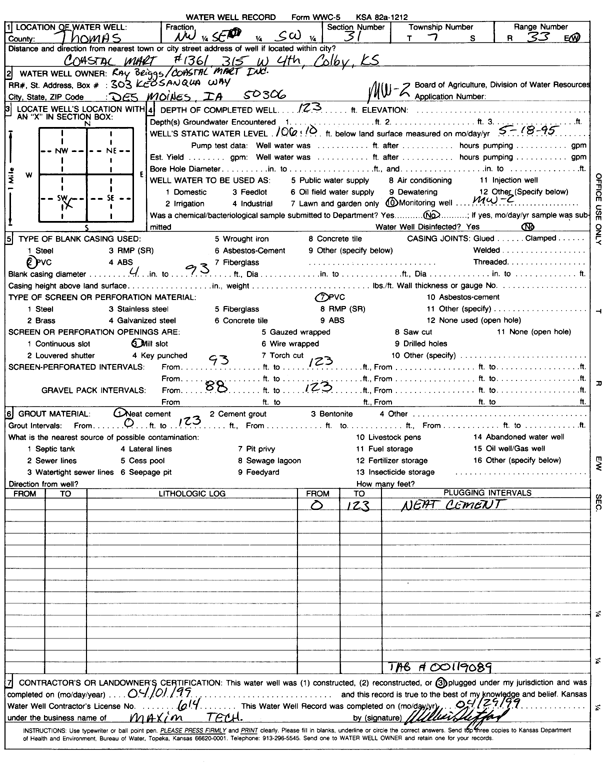
T7S, R33W, Sec. 31 NW SE SW |
Ray Beigs/Coastal Mart Inc | 123 ft. | 106 ft. | Monitoring well/observation/piezometer | MW 3 | Plugged | 02-Apr-1999 | Scan | |
|
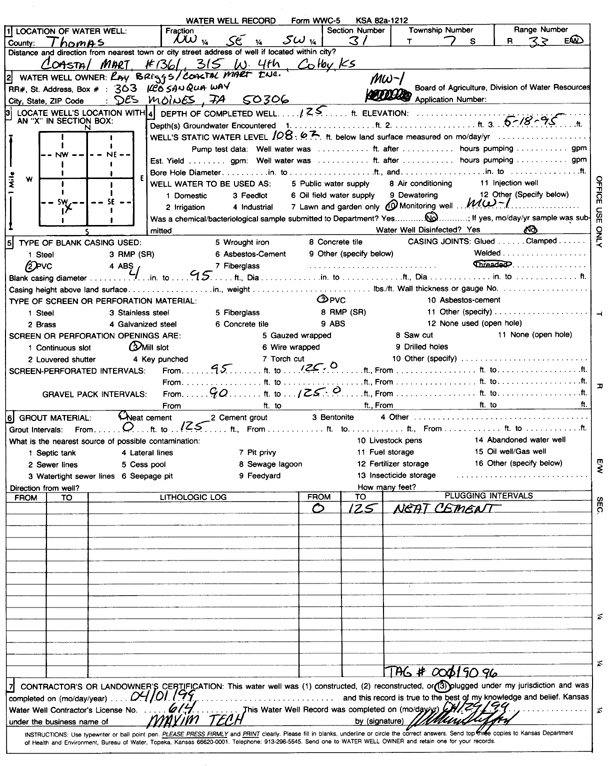
T7S, R33W, Sec. 31 NW SE SW |
Ray Briggs/Coastal Mart Inc. | 125 ft. | 108.62 ft. | Monitoring well/observation/piezometer | MW 1 | Plugged | 01-Apr-1999 | Scan | |
|
T7S, R33W, Sec. 31 NW SE SW |
Ray Briggs/Coastal Mart Inc. | 123 ft. | 106.1 ft. | Monitoring well/observation/piezometer | MW 2 | Plugged | 01-Apr-1999 | Scan | |
|
T7S, R33W, Sec. 31 NE SE NW |
Ross, Frank | 202 ft. | 96 ft. | Domestic | Constructed | 18-Mar-1983 | |||
|
T7S, R33W, Sec. 31 SE NW NW |
Rulier, Leon | 200 ft. | 79 ft. | Domestic | Constructed | 05-Sep-1980 | |||
|
T7S, R33W, Sec. 31 NW SW SE |
Service Oil | 126 ft. | Environmental Remediation, Air Sparge | AS 3 | Plugged | 19-Sep-2025 |
KOLAR |
||
|
T7S, R33W, Sec. 31 NW SW SE |
Service Oil | 109.3 ft. | Environmental Remediation, Soil Vapor Extraction | SVE 2 | Plugged | 19-Sep-2025 |
KOLAR |
||
|
T7S, R33W, Sec. 31 NW SW SE |
Service Oil | 109.8 ft. | Environmental Remediation, Soil Vapor Extraction | SVE 3 | Plugged | 19-Sep-2025 |
KOLAR |
||
|
T7S, R33W, Sec. 31 NW SW SE |
Service Oil | 125.5 ft. | Environmental Remediation, Air Sparge | AS 2 | Plugged | 19-Sep-2025 |
KOLAR |
||
|
T7S, R33W, Sec. 31 NW SW SE |
Service Oil | 126.5 ft. | Environmental Remediation, Air Sparge | AS 1 | Plugged | 19-Sep-2025 |
KOLAR |
||
|
T7S, R33W, Sec. 31 NW SW SE |
Service Oil | 125.15 ft. | Environmental Remediation, Air Sparge | AS 5 | Plugged | 19-Sep-2025 |
KOLAR |
||
|
T7S, R33W, Sec. 31 NW SW SE |
Service Oil | 129.15 ft. | Environmental Remediation, Air Sparge | AS 4 | Plugged | 19-Sep-2025 |
KOLAR |
||
|
T7S, R33W, Sec. 31 NW SW SE |
Service Oil | 110.05 ft. | Environmental Remediation, Soil Vapor Extraction | SVE 1 | Plugged | 19-Sep-2025 |
KOLAR |
||
|
T7S, R33W, Sec. 31 NE SW NW NW |
Shalz, Ron | 200 ft. | 110 ft. | 30 gpm. | Domestic | Constructed | 24-Jul-2017 |
KOLAR |
|
|
T7S, R33W, Sec. 31 NE SW NW NW |
Shelz, Ron and Melzny | 122 ft. | 108 ft. | Domestic | Plugged | 31-Jul-2017 | |||
|
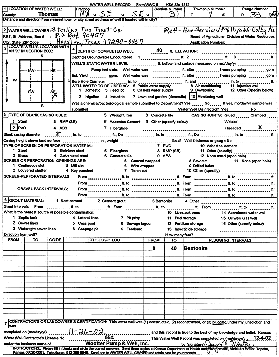
T7S, R33W, Sec. 31 NW SE SE |
Sterling Two Trust Co | 40 ft. | Monitoring well/observation/piezometer | Plugged | 26-Nov-2002 | Scan | |||
|
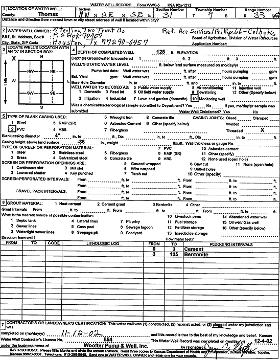
T7S, R33W, Sec. 31 NW SE SE |
Sterling Two Trust Co | 125 ft. | Monitoring well/observation/piezometer | Plugged | 12-Nov-2002 | Scan | |||
|
T7S, R33W, Sec. 31 NW SW SW |
Thompson, Dixie | 102 ft. | Domestic | Plugged | 14-Aug-1998 | ||||
|
T7S, R33W, Sec. 31 SE SE NE SE |
U.S. EPA Region 7 | 131 ft. | 120 ft. | Monitoring well/observation/piezometer | MW 6 S | Plugged | 18-Feb-2014 |
KOLAR |
|
|
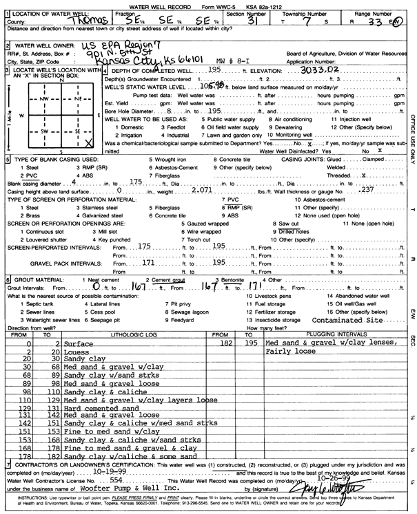
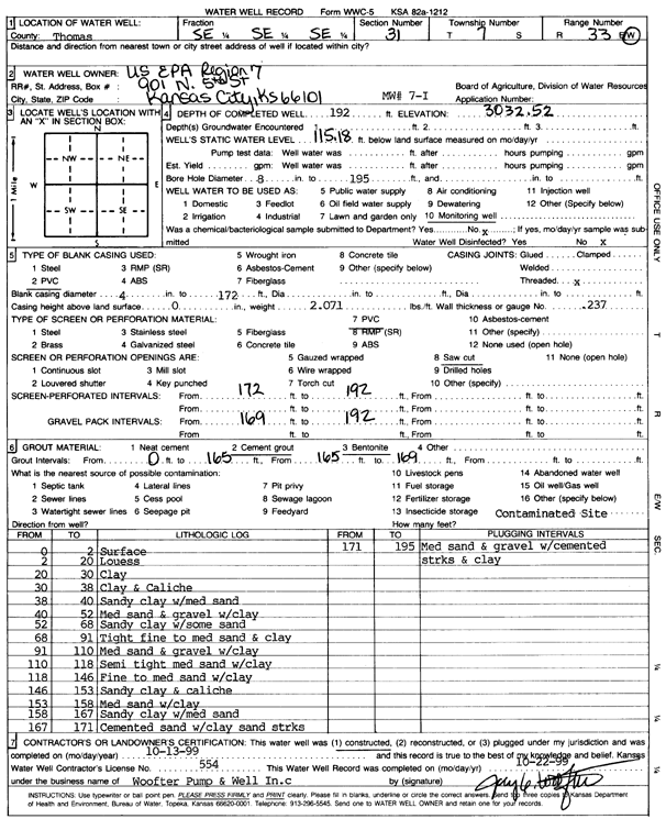
T7S, R33W, Sec. 31 SE SE SE |
U.S. EPA Region 7 | 195 ft. | 105.98 ft. | Monitoring well/observation/piezometer | MW 8 I | Constructed | 19-Oct-1999 | Scan | |
|
T7S, R33W, Sec. 31 SE SE SE |
U.S. EPA Region 7 | 192 ft. | 115.18 ft. | Monitoring well/observation/piezometer | MW 7 I | Constructed | 13-Oct-1999 | Scan | |
|
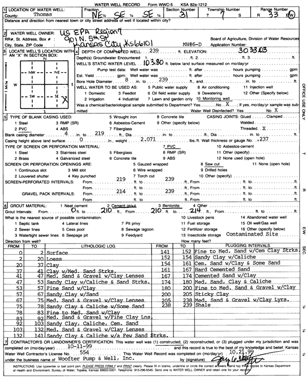
T7S, R33W, Sec. 31 NE SE SE |
U.S. EPA Region 7 | 239 ft. | 103.8 ft. | Monitoring well/observation/piezometer | MW 6 D | Constructed | 11-Oct-1999 | Scan | |
|
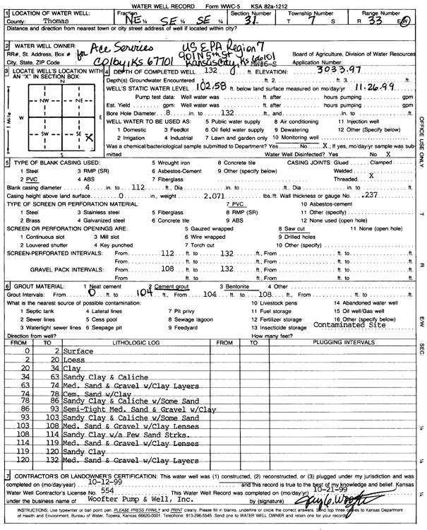
T7S, R33W, Sec. 31 NE SE SE |
U.S. EPA Region 7 | 132 ft. | 102.58 ft. | Monitoring well/observation/piezometer | MW 6 S | Constructed | 12-Oct-1999 | Scan | |
|
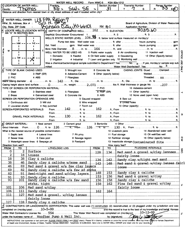
T7S, R33W, Sec. 31 NE SW SE |
U.S. EPA Region 7 | 162 ft. | 104.96 ft. | Monitoring well/observation/piezometer | MW 1 I | Constructed | 05-Oct-1999 | Scan | |
|
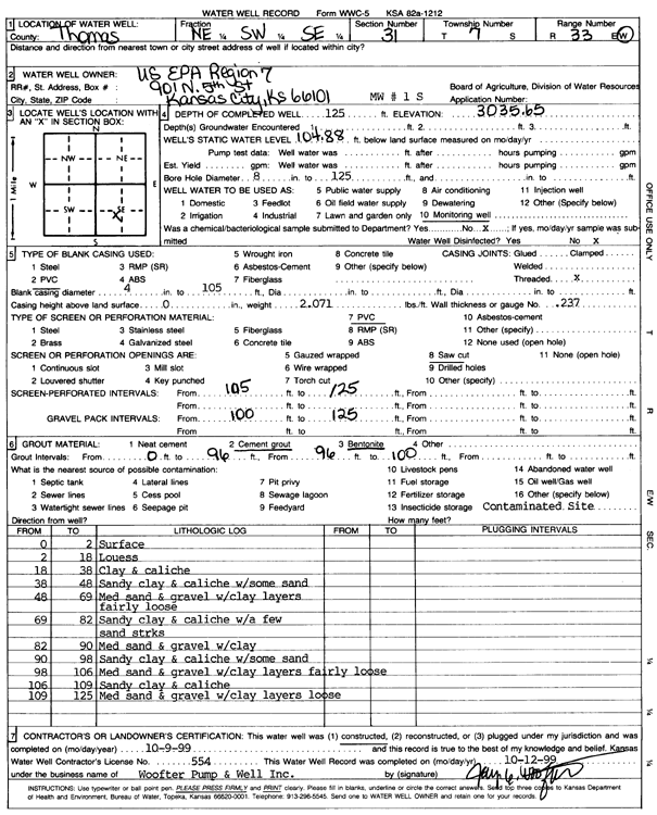
T7S, R33W, Sec. 31 NE SW SE |
U.S. EPA Region 7 | 125 ft. | 104.88 ft. | Monitoring well/observation/piezometer | MW 1 S | Constructed | 09-Oct-1999 | Scan | |
|
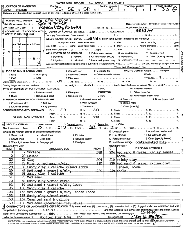
T7S, R33W, Sec. 31 SE SE SE |
U.S. EPA Region 7 | 239 ft. | 105.98 ft. | Monitoring well/observation/piezometer | MW 8 D | Constructed | 15-Oct-1999 | Scan | |
|
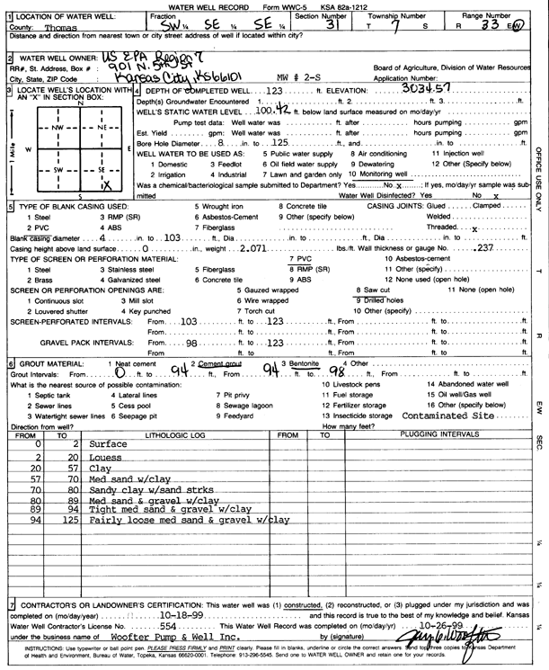
T7S, R33W, Sec. 31 SW SE SE |
U.S. EPA Region 7 | 123 ft. | 100.42 ft. | Monitoring well/observation/piezometer | MW 2 S | Constructed | 18-Oct-1999 | Scan | |
|
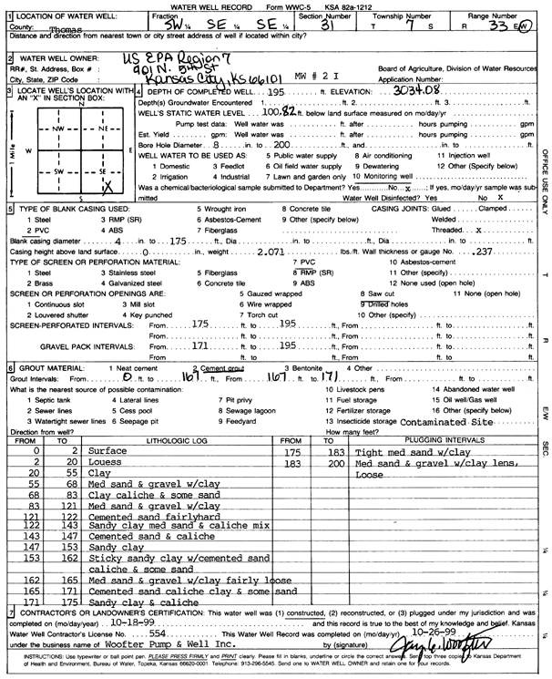
T7S, R33W, Sec. 31 SW SE SE |
U.S. EPA Region 7 | 195 ft. | 100.82 ft. | Monitoring well/observation/piezometer | MW 2 I | Constructed | 18-Oct-1999 | Scan | |
|
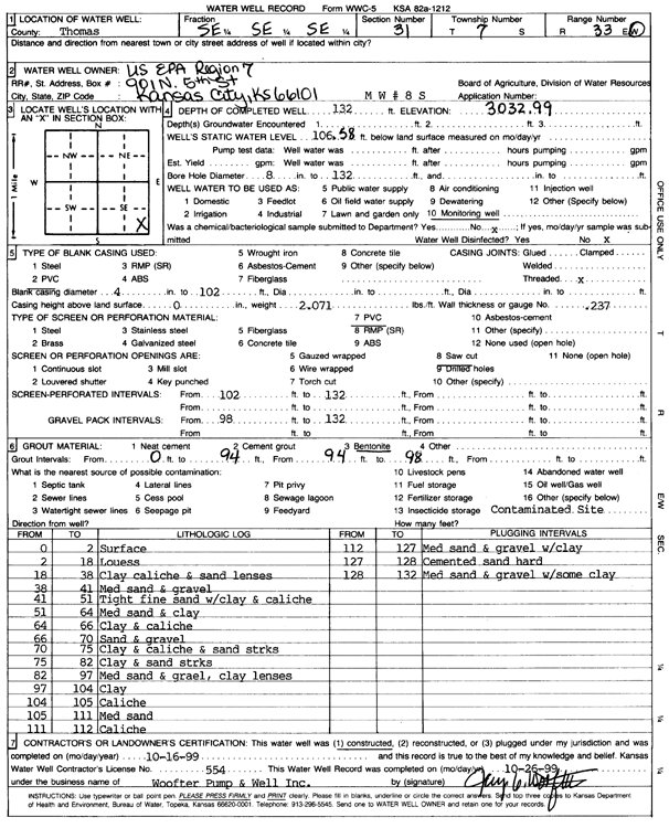
T7S, R33W, Sec. 31 SE SE SE |
U.S. EPA Region 7 | 132 ft. | 106.58 ft. | Monitoring well/observation/piezometer | MW 8 S | Constructed | 16-Oct-1999 | Scan | |
|
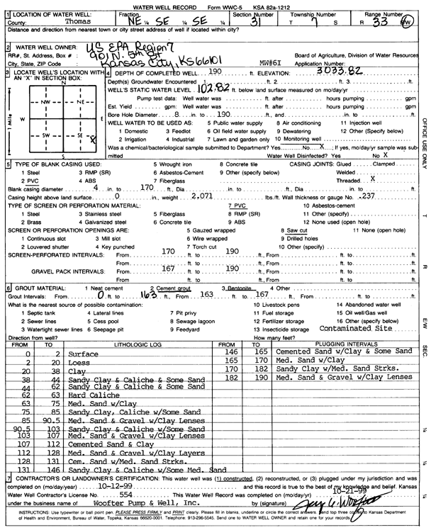
T7S, R33W, Sec. 31 NE SE SE |
U.S. EPA Region 7 | 190 ft. | 102.82 ft. | Monitoring well/observation/piezometer | MW 6 I | Constructed | 12-Oct-1999 | Scan | |
|
T7S, R33W, Sec. 31 SE SE NE SE |
U.S. EPA Region 7 | 190 ft. | 120 ft. | Monitoring well/observation/piezometer | MW 6 I | Plugged | 18-Feb-2014 |
KOLAR |
|
|
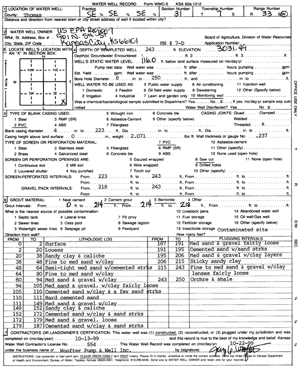
T7S, R33W, Sec. 31 SE SE SE |
U.S. EPA Region 7 | 243 ft. | 116 ft. | Monitoring well/observation/piezometer | MW 7 D | Constructed | 13-Oct-1999 | Scan | |
|
T7S, R33W, Sec. 31 SE SW SE |
U.S. EPA Region 7 | 140 ft. | Monitoring well/observation/piezometer | EX 6 S | Constructed | 28-Oct-2008 | |||
|
T7S, R33W, Sec. 31 SE SE NE SE |
U.S. EPA Region 7 | 237 ft. | 120 ft. | Monitoring well/observation/piezometer | MW 6 D | Plugged | 18-Feb-2014 |
KOLAR |
|
|
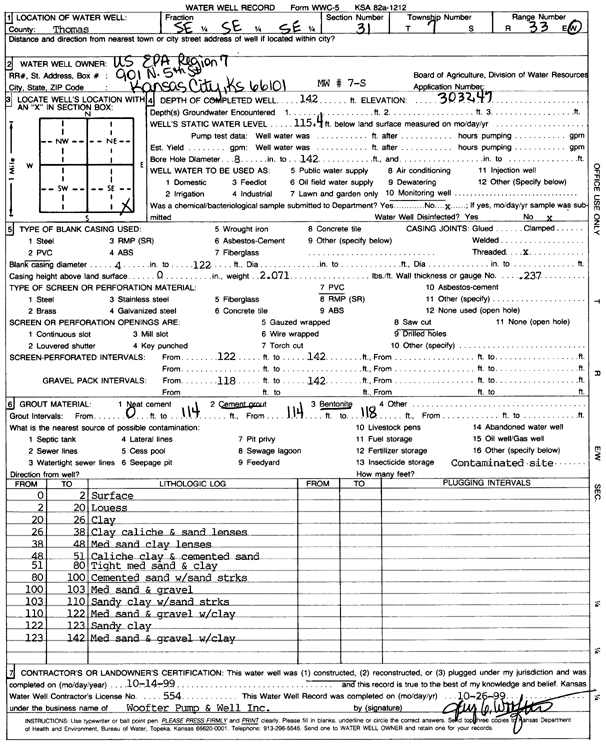
T7S, R33W, Sec. 31 SE SE SE |
U.S. EPA Region 7 | 142 ft. | 115.4 ft. | Monitoring well/observation/piezometer | MW 7 S | Constructed | 14-Oct-1999 | Scan | |
| View page: < Prev || 11 || 12 || 13 || 14 || 15 || 16 || 17 || 18 || 19 || 20 || Next > | |||||||||