Select location of well to view details.
Click on column heading to sort.
|
|
|
County: Wichita Select location of well to view details. Click on column heading to sort. |
|
|
|
| View page: < Prev || 11 || 12 || 13 || 14 || 15 || 16 || 17 || 18 || 19 || 20 || Next > | |||||||||
| T-R-S | Owner | Well Depth Ascend. Desc. |
Static Water Level Ascend. Desc. |
Est. Yield Ascend. Desc. |
Well Use | Other ID | Action Taken | Completion Date Ascend. Desc. |
Scan? |
|
T18S, R35W, Sec. 18 SE SE NE |
Mastel, Robert | 150 ft. | 131 ft. | Domestic | Constructed | 12-Jul-1988 | |||
|
T18S, R35W, Sec. 18 SE SE NE SE |
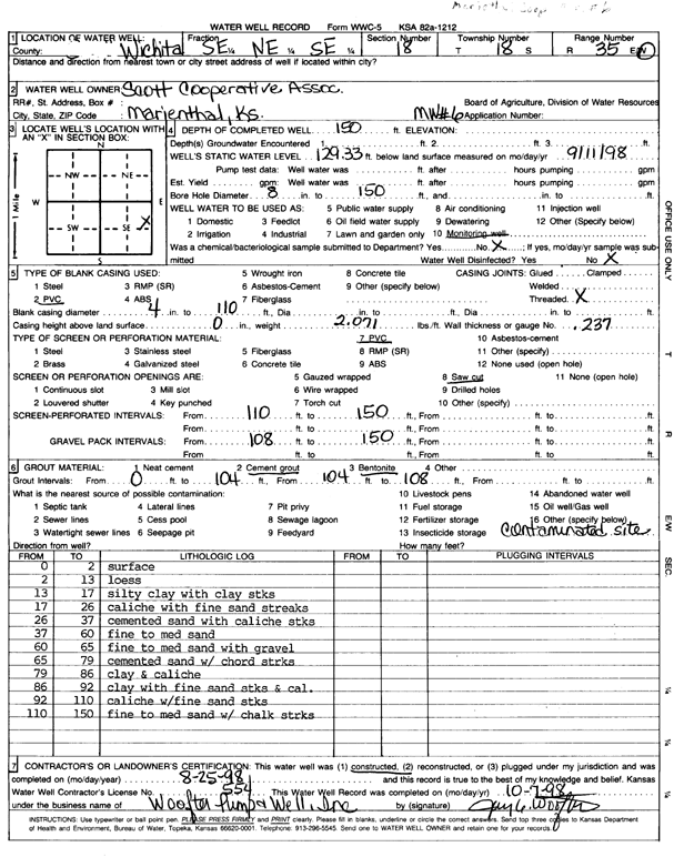
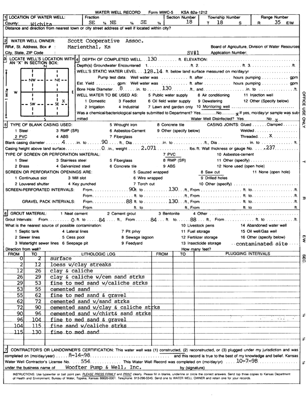
Scott Coop Assoc. | 150 ft. | 129.3 ft. | Monitoring well/observation/piezometer | MW 6 | Constructed | 25-Aug-1998 | Scan | |
|
T18S, R35W, Sec. 18 SE SE NE SE |
Scott Coop Assoc. | 150 ft. | 130 ft. | Monitoring well/observation/piezometer | MW 6 | Plugged | 14-Jul-2009 | ||
|
T18S, R35W, Sec. 18 SE SE NE SE |
Scott Coop Assoc. | 150 ft. | 129 ft. | Monitoring well/observation/piezometer | MW 1 | Plugged | 14-Jul-2009 | ||
|
T18S, R35W, Sec. 18 SE SE NE SE |
Scott Coop Assoc. | 70 ft. | Monitoring well/observation/piezometer | OB 4 | Plugged | 10-Jul-2009 | |||
|
T18S, R35W, Sec. 18 SE SE NE SE |
Scott Coop Assoc. | 150.4 ft. | 128.08 ft. | Monitoring well/observation/piezometer | MW 5 | Constructed | 22-Jul-1994 | ||
|
T18S, R35W, Sec. 18 SE SE NE SE |
Scott Coop Assoc. | 150 ft. | 129.9 ft. | Monitoring well/observation/piezometer | MW 3 | Constructed | 14-Jul-1994 | ||
|
T18S, R35W, Sec. 18 SE SE NE SE |
Scott Coop Assoc. | 150.2 ft. | 128.7 ft. | Monitoring well/observation/piezometer | MW 4 | Constructed | 16-Jul-1994 | ||
|
T18S, R35W, Sec. 18 SE SE NE SE |
Scott Coop Assoc. | 150.2 ft. | 127 ft. | Monitoring well/observation/piezometer | MW 1 | Constructed | 08-Jul-1994 | ||
|
T18S, R35W, Sec. 18 SE SE NE SE |
Scott Coop Assoc. | 150 ft. | 126.5 ft. | Monitoring well/observation/piezometer | MW 2 | Constructed | 10-Jul-1994 | ||
|
T18S, R35W, Sec. 18 SE SE NE SE |
Scott Coop Assoc. | 142 ft. | 130 ft. | Environmental Remediation, Air Sparge | AS 7 | Plugged | 10-Jul-2009 | ||
|
T18S, R35W, Sec. 18 SE SE NE SE |
Scott Coop Assoc. | 150 ft. | 129 ft. | Monitoring well/observation/piezometer | MW 8 | Plugged | 14-Jul-2009 | ||
|
T18S, R35W, Sec. 18 SE SE NE SE |
Scott Coop Assoc. | 142 ft. | 130 ft. | Environmental Remediation, Air Sparge | AS 1 | Plugged | 09-Jul-2009 | ||
|
T18S, R35W, Sec. 18 SE SE NE SE |
Scott Coop Assoc. | 142 ft. | Environmental Remediation, Air Sparge | AS 8 | Constructed | 15-Mar-2000 | |||
|
T18S, R35W, Sec. 18 SE SE NE SE |
Scott Coop Assoc. | 150 ft. | 129 ft. | Monitoring well/observation/piezometer | OB 1 | Plugged | 14-Jul-2009 | ||
|
T18S, R35W, Sec. 18 SE SE NE SE |
Scott Coop Assoc. | 70 ft. | Monitoring well/observation/piezometer | OB 2 | Plugged | 10-Jul-2009 | |||
|
T18S, R35W, Sec. 18 SE SE NE SE |
Scott Coop Assoc. | 130 ft. | Environmental Remediation, Soil Vapor Extraction | SVE 3 R | Reconstructed | 29-Aug-2000 | |||
|
T18S, R35W, Sec. 18 SE SE NE SE |
Scott Coop Assoc. | 142 ft. | Environmental Remediation, Air Sparge | AS 6 | Constructed | 14-Mar-2000 | |||
|
T18S, R35W, Sec. 18 SE SE NE SE |
Scott Coop Assoc. | 142 ft. | 129 ft. | Environmental Remediation, Air Sparge | AS 4 | Plugged | 09-Jul-2009 | ||
|
T18S, R35W, Sec. 18 SE SE NE SE |
Scott Coop Assoc. | 70 ft. | Environmental Remediation, Soil Vapor Extraction | SV 2 | Plugged | 10-Jul-2009 | |||
|
T18S, R35W, Sec. 18 SE SE NE SE |
Scott Coop Assoc. | 130 ft. | Environmental Remediation, Soil Vapor Extraction | SV 3 R | Plugged | 10-Jul-2009 | |||
|
T18S, R35W, Sec. 18 SE SE NE SE |
Scott Coop Assoc. | 70 ft. | Monitoring well/observation/piezometer | OB 3 | Plugged | 10-Jul-2009 | |||
|
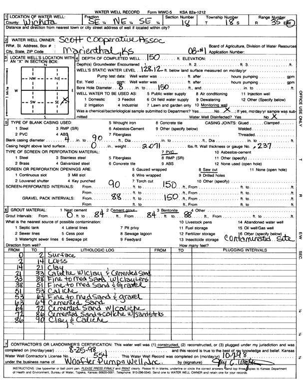
T18S, R35W, Sec. 18 SE SE NE SE |
Scott Coop Assoc. | 150 ft. | 128.12 ft. | Monitoring well/observation/piezometer | OB 1 | Constructed | 25-Aug-1998 | Scan | |
|
T18S, R35W, Sec. 18 SE SE NE SE |
Scott Coop Assoc. | 130 ft. | Environmental Remediation, Soil Vapor Extraction | SVE 4 | Constructed | 27-Mar-2000 | |||
|
T18S, R35W, Sec. 18 SE SE NE SE |
Scott Coop Assoc. | 150 ft. | 128 ft. | Monitoring well/observation/piezometer | MW 2 | Plugged | 14-Jul-2009 | ||
|
T18S, R35W, Sec. 18 SE SE NE SE |
Scott Coop Assoc. | 130 ft. | Environmental Remediation, Soil Vapor Extraction | SV 1 | Plugged | 09-Jul-2009 | |||
|
T18S, R35W, Sec. 18 SE SE NE SE |
Scott Coop Assoc. | 142 ft. | Environmental Remediation, Air Sparge | AS 7 | Constructed | 15-Mar-2000 | |||
|
T18S, R35W, Sec. 18 SE SE NE SE |
Scott Coop Assoc. | 142 ft. | 129 ft. | Environmental Remediation, Air Sparge | AS 2 | Plugged | 09-Jul-2009 | ||
|
T18S, R35W, Sec. 18 SE SE NE SE |
Scott Coop Assoc. | 142 ft. | 130 ft. | Environmental Remediation, Air Sparge | AS 8 | Plugged | 10-Jul-2009 | ||
|
T18S, R35W, Sec. 18 SE SE NE SE |
Scott Coop Assoc. | 142 ft. | Environmental Remediation, Air Sparge | AS 2 | Constructed | 22-Mar-2000 | |||
|
T18S, R35W, Sec. 18 SE SE NE SE |
Scott Coop Assoc. | 142 ft. | Environmental Remediation, Air Sparge | AS 4 | Constructed | 17-Mar-2000 | |||
|
T18S, R35W, Sec. 18 SE SE NE SE |
Scott Coop Assoc. | 130 ft. | Environmental Remediation, Soil Vapor Extraction | SVE 3 | Constructed | 23-Mar-2000 | |||
|
T18S, R35W, Sec. 18 SE SE NE SE |
Scott Coop Assoc. | 142 ft. | Environmental Remediation, Air Sparge | AS 5 | Constructed | 16-Mar-2000 | |||
|
T18S, R35W, Sec. 18 SE SE NE SE |
Scott Coop Assoc. | 130 ft. | Environmental Remediation, Soil Vapor Extraction | SVE 4 R | Reconstructed | 30-Aug-2000 | |||
|
T18S, R35W, Sec. 18 SE SE NE SE |
Scott Coop Assoc. | 142 ft. | Environmental Remediation, Air Sparge | AS 3 | Constructed | 21-Mar-2000 | |||
|
T18S, R35W, Sec. 18 SE SE NE SE |
Scott Coop Assoc. | 142 ft. | 130 ft. | Environmental Remediation, Air Sparge | AS 5 | Plugged | 09-Jul-2009 | ||
|
T18S, R35W, Sec. 18 SE SE NE SE |
Scott Coop Assoc. | 130 ft. | Environmental Remediation, Soil Vapor Extraction | SV 4 R | Plugged | 10-Jul-2009 | |||
|
T18S, R35W, Sec. 18 SE SE NE SE |
Scott Coop Assoc. | 142 ft. | 129 ft. | Environmental Remediation, Air Sparge | AS 3 | Plugged | 09-Jul-2009 | ||
|
T18S, R35W, Sec. 18 NE NE SE |
Scott Coop Assoc. | 145 ft. | 110 ft. | 50 gpm. | Domestic | Constructed | 16-Apr-1980 | ||
|
T18S, R35W, Sec. 18 SE SE NE SE |
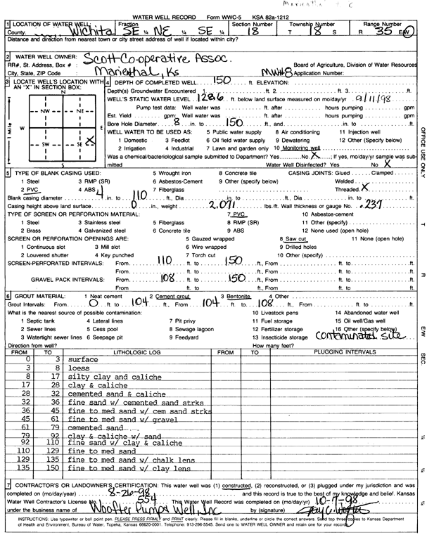
Scott Coop Assoc. | 150 ft. | 128.6 ft. | Monitoring well/observation/piezometer | MW 8 | Constructed | 26-Aug-1998 | Scan | |
|
T18S, R35W, Sec. 18 SE SE NE SE |
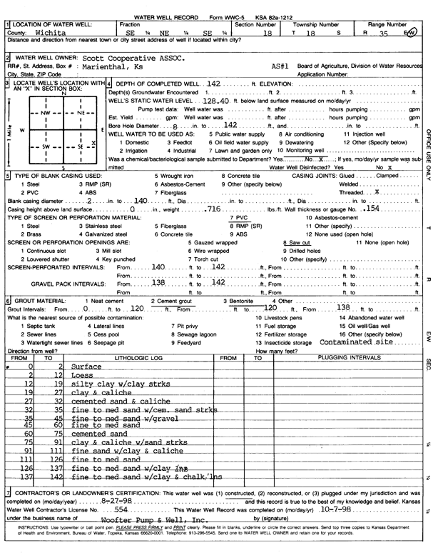
Scott Coop Assoc. | 142 ft. | 128.4 ft. | Environmental Remediation, Air Sparge | AS 1 | Constructed | 27-Aug-1998 | Scan | |
|
T18S, R35W, Sec. 18 SE SE NE SE |
Scott Coop Assoc. | 130 ft. | 128.14 ft. | Monitoring well/observation/piezometer | SV 1 | Constructed | 14-Aug-1998 | Scan | |
|
T18S, R35W, Sec. 18 SE SE NE SE |
Scott Coop Assoc. | 142 ft. | 130 ft. | Environmental Remediation, Air Sparge | AS 6 | Plugged | 09-Jul-2009 | ||
|
T18S, R35W, Sec. 18 SE SE NE SE |
Scott Coop Assoc. | 150 ft. | 130 ft. | Monitoring well/observation/piezometer | MW 4 | Plugged | 14-Jul-2009 | ||
|
T18S, R35W, Sec. 19 NW SW NE |
Abercrombie Drilling/J.W. Zellner | 155 ft. | 92 ft. | Oil Field Water Supply | Constructed | 03-Dec-1994 | |||
|
T18S, R35W, Sec. 19 SE SE NW |
Zellner, Joe, Jr. | 50 ft. | Domestic | Plugged | 23-May-2008 | ||||
|
T18S, R35W, Sec. 20 SE SE SW |
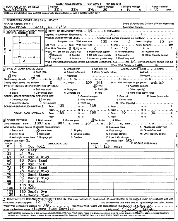
Graff, Justin | 145 ft. | Domestic | Constructed | 11-Oct-2000 | Scan | |||
|
T18S, R35W, Sec. 20 SE SE SW |
Graff, Justin | 145 ft. | 102 ft. | 10 gpm. | Domestic | Constructed | 13-Jul-1977 | ||
|
T18S, R35W, Sec. 21 NW NW NW |
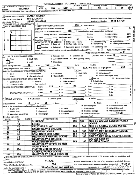
Ridder, Elmer | 163 ft. | 145 ft. | Irrigation | Constructed | 15-Jul-2000 | Scan | ||
|
T18S, R35W, Sec. 26 SW NW NW |
Graff, Victor | 110 ft. | 90 ft. | 10 gpm. | Domestic | Constructed | 20-Jan-1978 | ||
| View page: < Prev || 11 || 12 || 13 || 14 || 15 || 16 || 17 || 18 || 19 || 20 || Next > | |||||||||