Select location of well to view details.
Click on column heading to sort.
|
|
|
County: Wichita Select location of well to view details. Click on column heading to sort. |
|
|
|
| View page: < Prev || 11 || 12 || 13 || 14 || 15 || 16 || 17 || 18 || 19 || 20 || Next > | |||||||||
| T-R-S | Owner | Well Depth Ascend. Desc. |
Static Water Level Ascend. Desc. |
Est. Yield Ascend. Desc. |
Well Use | Other ID | Action Taken | Completion Date Ascend. Desc. |
Scan? |
|
T18S, R36W, Sec. 25 NW NW NW |
McRae, Jim | 126 ft. | 70 ft. | 50 gpm. | Domestic | Constructed | 21-Apr-1979 | ||
|
T18S, R36W, Sec. 26 NE NE NE |
Barnhardt, Gordon | 125 ft. | 65 ft. | 10 gpm. | Domestic | Constructed | 28-Jul-1977 | ||
|
T18S, R36W, Sec. 27 NE SW NW |
Krenzel, Jess | 150 ft. | 75 ft. | 730 gpm. | Irrigation | Constructed | 20-Jan-1975 | ||
|
T18S, R36W, Sec. 28 NW NW NE |
Burch, Zelma | 162 ft. | 102 ft. | 10 gpm. | Domestic | Constructed | 18-Aug-1977 | ||
|
T18S, R36W, Sec. 28 NW NW SW |
Geyer, Elmer | 156 ft. | 109 ft. | Domestic | Constructed | 19-May-1983 | |||
|
T18S, R36W, Sec. 30 SW SE NE |
Case, Vic | 150 ft. | 98 ft. | 5 gpm. | Domestic | Constructed | 25-Jan-1975 | ||
|
T18S, R36W, Sec. 30 NW NE NE |
Case, Vic | 152 ft. | 128 ft. | Domestic | Constructed | 30-Apr-1986 | |||
|
T18S, R36W, Sec. 30 NW NW NE |
Case, Vic | 145 ft. | 120 ft. | Domestic | Constructed | 13-May-1986 | |||
|
T18S, R36W, Sec. 30 SE SE SW |
Wichita County Landfill | 119.42 ft. | 101.16 ft. | Monitoring well/observation/piezometer | MW 2 | Constructed | 22-Jul-1993 | ||
|
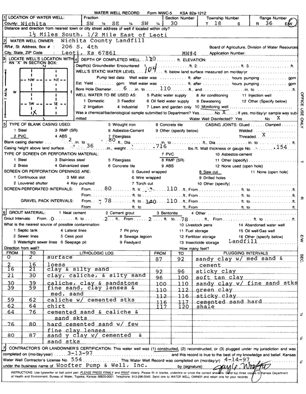
T18S, R36W, Sec. 30 SW SE SW |
Wichita County Landfill | 110 ft. | 104 ft. | Monitoring well/observation/piezometer | MW 4 | Constructed | 13-Mar-1997 | Scan | |
|
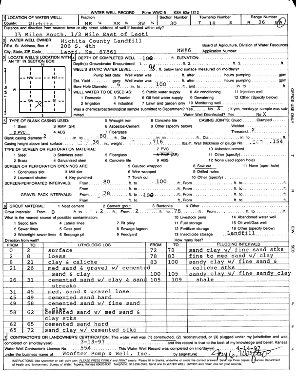
T18S, R36W, Sec. 30 NE SE SW |
Wichita County Landfill | 109 ft. | 98 ft. | Monitoring well/observation/piezometer | MW 6 | Constructed | 13-Mar-1997 | Scan | |
|
T18S, R36W, Sec. 30 SW SE SW |
Wichita County Landfill | 131.27 ft. | 102.14 ft. | Monitoring well/observation/piezometer | MW 1 | Constructed | 21-Jul-1993 | ||
|
T18S, R36W, Sec. 30 SE SE SW |
Wichita County Landfill | 117.19 ft. | 99.15 ft. | Monitoring well/observation/piezometer | MW 3 | Constructed | 22-Jul-1993 | ||
|
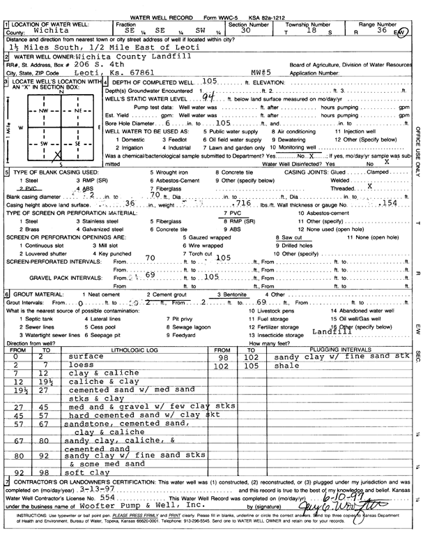
T18S, R36W, Sec. 30 SE SE SW |
Wichita County Landfill | 105 ft. | 94 ft. | Monitoring well/observation/piezometer | MW 5 | Constructed | 13-Mar-1997 | Scan | |
|
T18S, R37W, Sec. 1 SW SW SW |
Nuss, Melvin | 190 ft. | 146 ft. | Irrigation | Plugged | 07-Jul-1992 | |||
|
T18S, R37W, Sec. 1 NW NW NW |
Nuss, Melvin | 184 ft. | 147 ft. | Irrigation | Plugged | 07-Jul-1992 | |||
|
T18S, R37W, Sec. 1 SE NW SE |
Nuss, Melvin | 180 ft. | 150 ft. | Irrigation | Plugged | 11-Oct-1994 | |||
|
T18S, R37W, Sec. 1 NW NW NW |
Nuss, Melvin | 184 ft. | 147 ft. | Irrigation | Plugged | 07-Jul-1992 | |||
|
T18S, R37W, Sec. 2 NE NE NE |
Fisher, Jess | 195 ft. | 141 ft. | 18 gpm. | Domestic | Constructed | 14-Sep-1976 | ||
|
T18S, R37W, Sec. 2 NE NE |
Whitham Land and Cattle | 202 ft. | Irrigation | Reconstructed | 20-Oct-2010 | ||||
|
T18S, R37W, Sec. 2 SE NE NE |
Whitham Land and Cattle | 200 ft. | Irrigation | Constructed | 06-Apr-2006 | ||||
|
T18S, R37W, Sec. 4 SE SE NE |
Zellner, Joe, Jr. | 178 ft. | 21 ft. | Irrigation | Plugged | 22-May-2008 | |||
|
T18S, R37W, Sec. 6 SW NW NE |
Whitham Land and Cattle | 203 ft. | 163 ft. | Irrigation | Constructed | 15-Apr-2010 | |||
|
T18S, R37W, Sec. 7 SW SW NW |
Jaegers Farms | 164 ft. | 129 ft. | Irrigation | Plugged | 08-Jul-1992 | |||
|
T18S, R37W, Sec. 8 SW SW SW |
Holland, Ben | 211 ft. | 146 ft. | 675 gpm. | Irrigation | Constructed | 11-Apr-1978 | ||
|
T18S, R37W, Sec. 8 SW SW NW |
Whitham, Charles | 196 ft. | 140 ft. | 650 gpm. | Irrigation | Constructed | 31-Dec-1975 | ||
|
T18S, R37W, Sec. 8 SE NE SE |
Zellner, Joe | 194 ft. | 84 ft. | Irrigation | Plugged | 24-Oct-2007 | |||
|
T18S, R37W, Sec. 10 NW SW NW |
Whitham Land and Cattle | 203 ft. | 163 ft. | Irrigation | Reconstructed | 23-Feb-2009 | |||
|
T18S, R37W, Sec. 11 SE SE SE |
Crowley, Willis | 197 ft. | 126 ft. | Domestic | Constructed | 11-Aug-1975 | |||
|
T18S, R37W, Sec. 12 SE NW NW |
Ames, Norman | 195 ft. | 123 ft. | 10 gpm. | Domestic | Constructed | 30-Apr-1977 | ||
|
T18S, R37W, Sec. 13 NE NW NW |
Beamer, Jeffrey | 184 ft. | 142 ft. | 20 gpm. | Domestic | Constructed | 21-May-1992 | ||
|
T18S, R37W, Sec. 13 NE NW NE NW |
Berning Ag | 186 ft. | 151 ft. | 20 gpm. | Domestic | Constructed | 06-Nov-2020 |
KOLAR |
|
|
T18S, R37W, Sec. 13 SE SE SW |
Case, Dwight | 150 ft. | 147 ft. | Domestic | Plugged | 27-Jan-1992 | |||
|
T18S, R37W, Sec. 13 NE NW SW |
City of Leoti | 144 ft. | Test hole/well | Well 7 | Plugged | 26-Oct-2007 | |||
|
T18S, R37W, Sec. 13 NE SW SW |
City of Leoti | 170 ft. | 124 ft. | Monitoring well/observation/piezometer | PZ 3-77 | Constructed | 09-Nov-1977 | ||
|
T18S, R37W, Sec. 13 NE NW SW |
City of Leoti | 172 ft. | 122 ft. | Monitoring well/observation/piezometer | PZ 4-77 | Constructed | 10-Nov-1977 | ||
|
T18S, R37W, Sec. 13 NW SE NE |
City of Leoti | 185 ft. | 136 ft. | Monitoring well/observation/piezometer | PZ 5-77 | Constructed | 10-Nov-1977 | ||
|
T18S, R37W, Sec. 13 NW NE SW SW |
City of Leoti | 166 ft. | Test hole/well | Well 11 | Plugged | 26-Oct-2007 | |||
|
T18S, R37W, Sec. 13 NE SW SW |
City of Leoti | 168 ft. | 126 ft. | 150 gpm. | Public Water Supply | Well 4A | Constructed | 16-Jul-1978 | |
|
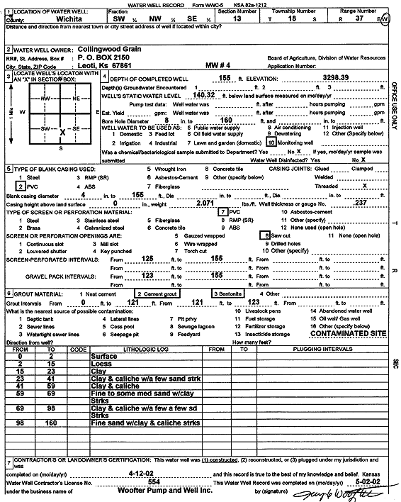
T18S, R37W, Sec. 13 SW NW SE |
Collingwood Grain, Inc. | 155 ft. | 140.3 ft. | Monitoring well/observation/piezometer | MW 4 | Constructed | 12-Apr-2002 | Scan | |
|
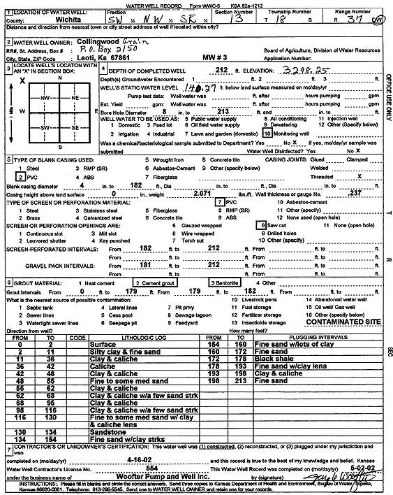
T18S, R37W, Sec. 13 SW NW SE |
Collingwood Grain, Inc. | 212 ft. | 140.3 ft. | Monitoring well/observation/piezometer | MW 3 | Constructed | 16-Apr-2002 | Scan | |
|
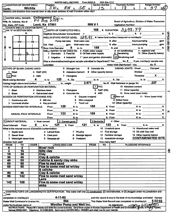
T18S, R37W, Sec. 13 SW NW SE |
Collingwood Grain, Inc. | 155 ft. | 139.9 ft. | Monitoring well/observation/piezometer | MW 1 | Constructed | 11-Apr-2002 | Scan | |
|
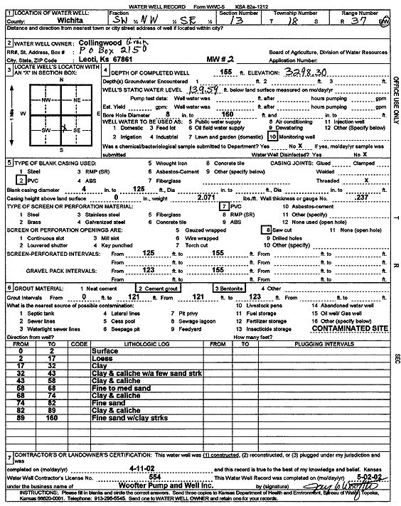
T18S, R37W, Sec. 13 SW NW SE |
Collingwood Grain, Inc. | 155 ft. | 139.6 ft. | Monitoring well/observation/piezometer | MW 2 | Constructed | 11-Apr-2002 | Scan | |
|
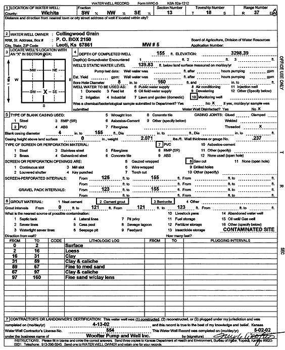
T18S, R37W, Sec. 13 SW NW SE |
Collingwood Grain, Inc. | 155 ft. | 139.83 ft. | Monitoring well/observation/piezometer | MW 5 | Constructed | 13-Apr-2002 | Scan | |
|
T18S, R37W, Sec. 13 SW NW SE |
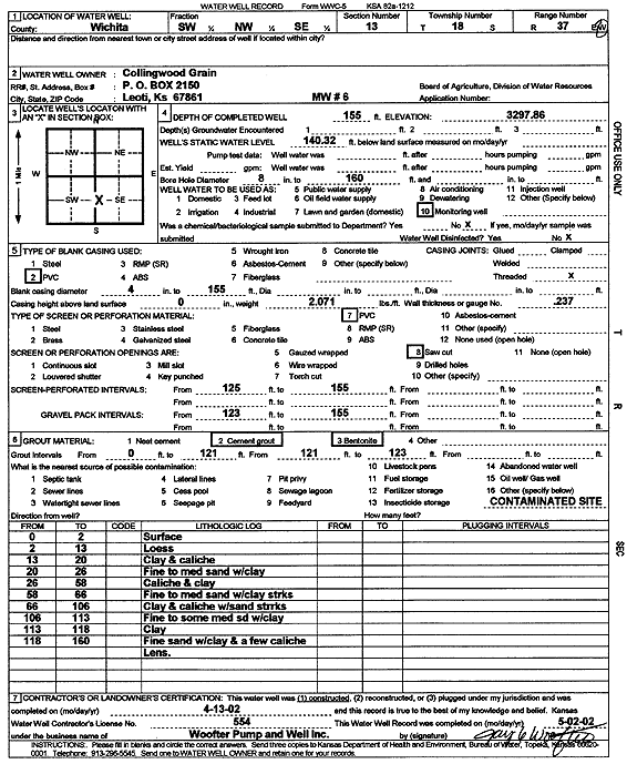
Collingwood Grain, Inc. | 155 ft. | 140.32 ft. | Monitoring well/observation/piezometer | MW 6 | Constructed | 13-Apr-2002 | Scan | |
|
T18S, R37W, Sec. 13 SW NE NE |
Crowley, Asher | 145 ft. | 127 ft. | Domestic | Plugged | 30-Apr-1992 | |||
|
T18S, R37W, Sec. 13 SW NE NE |
Crowley, Asher | 82 ft. | Domestic | Plugged | 15-Feb-1992 | ||||
|
T18S, R37W, Sec. 13 NW NW NW |
Duncan, Leland | 180 ft. | 125 ft. | 10 gpm. | Domestic | Constructed | 25-Sep-1976 | ||
|
T18S, R37W, Sec. 13 NW SE SE |
Foushee, Virgil | 90 ft. | Domestic | Plugged | 15-Feb-1992 | ||||
|
T18S, R37W, Sec. 13 SW SW SE SE |
Presto Convenience Stores LLC | 155.5 ft. | 130.28 ft. | Monitoring well/observation/piezometer | MW 2 | Plugged | 16-Jun-2009 | ||
| View page: < Prev || 11 || 12 || 13 || 14 || 15 || 16 || 17 || 18 || 19 || 20 || Next > | |||||||||