Select location of well to view details.
Click on column heading to sort.
|
|
|
County: Coffey Select location of well to view details. Click on column heading to sort. |
|
|
|
| View page: 1 || 2 || 3 || 4 || 5 || 6 || 7 || 8 || 9 || 10 || Next > | |||||||||
| T-R-S | Owner | Well Depth Ascend. Desc. |
Static Water Level Ascend. Desc. |
Est. Yield Ascend. Desc. |
Well Use | Other ID | Action Taken | Completion Date Ascend. Desc. |
Scan? |
|
T21S, R15E, Sec. 24 NE SE NE |
Coffey County | 46 ft. | 15.3 ft. | Monitoring well/observation/piezometer | DW-IT | Constructed | 19-Jul-1996 | ||
|
T21S, R15E, Sec. 24 SE SE NW |
Coffey County | 57 ft. | Monitoring well/observation/piezometer | DW 7 | Constructed | 06-Nov-1997 | |||
|
T21S, R15E, Sec. 24 NE NE SE |
Coffey County Landfill | 5.5 ft. | Monitoring well/observation/piezometer | Constructed | 11-Aug-1993 | ||||
|
T21S, R15E, Sec. 24 NE NE SE |
Coffey County Landfill | 8 ft. | Monitoring well/observation/piezometer | Constructed | 11-Aug-1993 | ||||
|
T21S, R15E, Sec. 24 NE NE SE |
Coffey County Landfill | 7 ft. | Monitoring well/observation/piezometer | MW 1 | Constructed | 11-Aug-1993 | |||
|
T21S, R15E, Sec. 24 SE SW |
Harris, John Hawkes | 204 ft. | 75 ft. | .75 gpm. | Domestic | Constructed | 08-Nov-1975 | ||
|
T21S, R15E, Sec. 24 NW SE NW NW |
Sloyer, Jeff and Beth | 200 ft. | Geothermal, Closed Loop, Vertical | Constructed | 10-Sep-2013 |
KOLAR |
|||
|
T21S, R15E, Sec. 24 SE SE SE |
Wolf Creek Nuclear Operating Plant | 42 ft. | 6 ft. | Monitoring well/observation/piezometer | MW 8 C | Constructed | 20-Jul-2009 | ||
|
T21S, R15E, Sec. 24 SE SE SE |
Wolf Creek Nuclear Operating Plant | 17 ft. | 5.5 ft. | Monitoring well/observation/piezometer | MW 8 B | Constructed | 20-Jul-2009 | ||
|
T21S, R15E, Sec. 26 SW SW NW |
Coffey Co. Economic Development | 30 ft. | 11.89 ft. | Monitoring well/observation/piezometer | MW 6 | Constructed | 21-Apr-2026 |
KOLAR |
|
|
T21S, R15E, Sec. 26 SW SW NW |
Coffey Co. Economic Development | 31.5 ft. | 31.05 ft. | Monitoring well/observation/piezometer | MW 7 | Constructed | 21-Apr-2026 |
KOLAR |
|
|
T21S, R15E, Sec. 26 SW SW NW |
Coffey Co. Economic Development | 20 ft. | 7.64 ft. | Monitoring well/observation/piezometer | MW 4 | Constructed | 21-Apr-2026 |
KOLAR |
|
|
T21S, R15E, Sec. 26 SW SW NW |
Coffey Co. Economic Development | 20 ft. | 11.89 ft. | Monitoring well/observation/piezometer | MW 5 | Constructed | 21-Apr-2026 |
KOLAR |
|
|
T21S, R15E, Sec. 26 SW NW SW |
Rickabaugh, Sandra | 8.5 ft. | Monitoring well/observation/piezometer | MW 10 | Plugged | 15-Feb-2001 | Scan | ||
|
T21S, R15E, Sec. 26 SW NW SW |
Rickabaugh, Sandra | 7.5 ft. | Monitoring well/observation/piezometer | MW 5 | Plugged | 15-Feb-2001 | Scan | ||
|
T21S, R15E, Sec. 26 SW NW SW |
Rickabaugh, Sandra | 7.5 ft. | Monitoring well/observation/piezometer | MW 8 | Plugged | 15-Feb-2001 | Scan | ||
|
T21S, R15E, Sec. 26 SW NW SW |
Rickabaugh, Sandra | 10 ft. | Monitoring well/observation/piezometer | MW 6 | Plugged | 15-Feb-2001 | Scan | ||
|
T21S, R15E, Sec. 26 SW NW SW |
Rickabaugh, Sandra | 9.5 ft. | Monitoring well/observation/piezometer | MW 9 | Plugged | 15-Feb-2001 | Scan | ||
|
T21S, R15E, Sec. 26 SW NW NW |
Rickabaugh, Sandra | 12 ft. | Monitoring well/observation/piezometer | MW 6 R | Constructed | 04-Mar-2008 | |||
|
T21S, R15E, Sec. 26 SW NW SW |
Rickabaugh, Sandra | 9 ft. | Monitoring well/observation/piezometer | MW 11 | Constructed | 04-Mar-2008 | |||
|
T21S, R15E, Sec. 26 SW NW SW |
Rickabaugh, Sandra | 9 ft. | Monitoring well/observation/piezometer | MW 3 | Plugged | 15-Feb-2001 | Scan | ||
|
T21S, R15E, Sec. 26 NE NE NW |
Robeson, Jessie | 25 ft. | 15 ft. | 3 gpm. | Domestic | Constructed | 15-May-1985 | ||
|
T21S, R15E, Sec. 26 SW SW NW |
Smitty's Apco | 11 ft. | 9.82 ft. | Monitoring well/observation/piezometer | MW 8 | Constructed | 29-Jan-1997 | ||
|
T21S, R15E, Sec. 26 SW SW NW |
Smitty's Apco | 11 ft. | 9.62 ft. | Monitoring well/observation/piezometer | MW 6 | Constructed | 29-Jan-1997 | ||
|
T21S, R15E, Sec. 26 SW NW SW |
United Oil | 10 ft. | 2.26 ft. | Monitoring well/observation/piezometer | MW 1 | Constructed | 19-Mar-1997 | ||
|
T21S, R15E, Sec. 26 SW SW NW SW |
United Oil | 11.59 ft. | 3.32 ft. | Monitoring well/observation/piezometer | MW 6 R | Plugged | 26-Jan-2010 | ||
|
T21S, R15E, Sec. 26 SW NW SW |
United Oil | 9.21 ft. | 2.87 ft. | Monitoring well/observation/piezometer | MW 4 | Plugged | 10-Mar-2010 | ||
|
T21S, R15E, Sec. 26 SW SW NW SW |
United Oil | 8.96 ft. | 3.31 ft. | Monitoring well/observation/piezometer | MW 13 | Plugged | 26-Jan-2010 | ||
|
T21S, R15E, Sec. 26 SW NW SW |
United Oil | 9 ft. | 3.42 ft. | Monitoring well/observation/piezometer | MW 2 | Plugged | 28-Jul-1998 | ||
|
T21S, R15E, Sec. 26 SW NW SW |
United Oil | 9 ft. | 2.82 ft. | Monitoring well/observation/piezometer | MW 2 | Constructed | 19-Mar-1997 | ||
|
T21S, R15E, Sec. 26 SW NW SW |
United Oil | 8.5 ft. | 2.1 ft. | Monitoring well/observation/piezometer | MW 10 | Constructed | 20-Mar-1997 | ||
|
T21S, R15E, Sec. 26 SW SW NW SW |
United Oil | 9.35 ft. | 3.19 ft. | Monitoring well/observation/piezometer | MW 7 | Plugged | 26-Jan-2010 | ||
|
T21S, R15E, Sec. 26 SW SW NW SW |
United Oil | 8.54 ft. | 1.78 ft. | Monitoring well/observation/piezometer | MW 11 | Plugged | 26-Jan-2010 | ||
|
T21S, R15E, Sec. 26 SW SW NW SW |
United Oil | 9.72 ft. | 2.47 ft. | Monitoring well/observation/piezometer | MW 1 | Plugged | 26-Jan-2010 | ||
|
T21S, R15E, Sec. 26 SW NW SW |
United Oil | 7.5 ft. | 1.19 ft. | Monitoring well/observation/piezometer | MW 5 | Constructed | 19-Mar-1997 | ||
|
T21S, R15E, Sec. 26 SW NW SW |
United Oil | 7.5 ft. | 2.39 ft. | Monitoring well/observation/piezometer | MW 8 | Constructed | 20-Mar-1997 | ||
|
T21S, R15E, Sec. 26 NW SW SW |
United Oil | 9 ft. | 1.59 ft. | Monitoring well/observation/piezometer | MW 3 | Constructed | 19-Mar-1997 | ||
|
T21S, R15E, Sec. 26 SW NW SW |
United Oil | 9.5 ft. | 4.27 ft. | Monitoring well/observation/piezometer | MW 7 | Constructed | 20-Mar-1997 | ||
|
T21S, R15E, Sec. 26 SW SW NW SW |
United Oil | 8.16 ft. | 1.26 ft. | Monitoring well/observation/piezometer | MW 12 | Plugged | 26-Jan-2010 | ||
|
T21S, R15E, Sec. 26 NW SW SW |
United Oil | 9.5 ft. | 3.02 ft. | Monitoring well/observation/piezometer | MW 4 | Constructed | 19-Mar-1997 | ||
|
T21S, R15E, Sec. 27 SE SE NE |
Coffey Co. Economic Development | 20 ft. | 9.49 ft. | Monitoring well/observation/piezometer | MW 2 | Constructed | 20-Apr-2026 |
KOLAR |
|
|
T21S, R15E, Sec. 27 NE SE NE |
Coffey Co. Economic Development | 27.5 ft. | 21.8 ft. | Monitoring well/observation/piezometer | MW 8 | Constructed | 22-Apr-2026 |
KOLAR |
|
|
T21S, R15E, Sec. 27 SE SE NE |
Coffey Co. Economic Development | 20 ft. | 13.02 ft. | Monitoring well/observation/piezometer | MW 3 | Constructed | 20-Apr-2026 |
KOLAR |
|
|
T21S, R15E, Sec. 27 SE SE NE |
Coffey Co. Economic Development | 22.5 ft. | 20.22 ft. | Monitoring well/observation/piezometer | MW 9 | Constructed | 22-Apr-2026 |
KOLAR |
|
|
T21S, R15E, Sec. 27 SE SE NE |
Coffey Co. Economic Development | 20 ft. | 7.76 ft. | Monitoring well/observation/piezometer | MW 1 | Constructed | 20-Apr-2026 |
KOLAR |
|
|
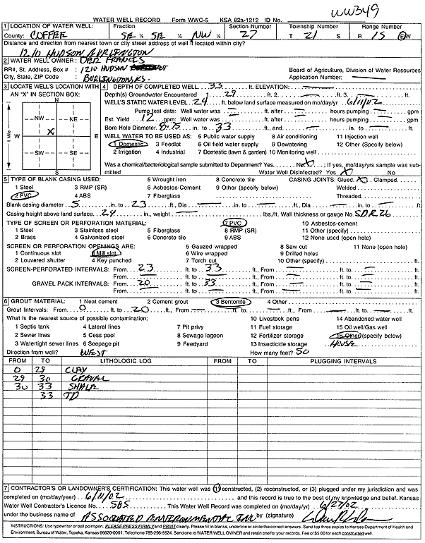
T21S, R15E, Sec. 27 SE SE NW |
Francis, Dee | 33 ft. | 24 ft. | 12 gpm. | Domestic | WW 349 | Constructed | 11-Jun-2002 | Scan |
|
T21S, R15E, Sec. 27 NE SW NE |
Hayes, Ralph | 65 ft. | 7 ft. | 10 gpm. | Domestic | Constructed | 29-May-1989 | ||
|
T21S, R15E, Sec. 27 NW SW SW |
Johnson, Alvin J. and Doris M. | 50 ft. | 21 ft. | 12 gpm. | Domestic | Constructed | 19-Aug-2002 | Scan | |
|
T21S, R15E, Sec. 27 SW NW SW |
Kewley, Mike | 55 ft. | 20 ft. | 10 gpm. | Domestic | Constructed | 19-Aug-2002 | Scan | |
|
T21S, R15E, Sec. 27 SE NE NE SW |
Lewis Oil Company Inc | 25 ft. | 18.98 ft. | Monitoring well/observation/piezometer | MW 16 | Plugged | 25-Feb-2021 | ||
| View page: 1 || 2 || 3 || 4 || 5 || 6 || 7 || 8 || 9 || 10 || Next > | |||||||||