Select location of well to view details.
Click on column heading to sort.
|
|
|
County: Coffey Select location of well to view details. Click on column heading to sort. |
|
|
|
| View page: 1 || 2 || 3 || 4 || 5 || 6 || 7 || 8 || 9 || 10 || Next > | |||||||||
| T-R-S | Owner | Well Depth Ascend. Desc. |
Static Water Level Ascend. Desc. |
Est. Yield Ascend. Desc. |
Well Use | Other ID | Action Taken | Completion Date Ascend. Desc. |
Scan? |
|
T21S, R15E, Sec. 27 SW NW NW SE |
Lewis Oil Company Inc | 25 ft. | 19.04 ft. | Monitoring well/observation/piezometer | MW 17 | Plugged | 25-Feb-2021 | ||
|
T21S, R15E, Sec. 27 SW NW NW SE |
Lewis Oil Company Inc | 24 ft. | 17.88 ft. | Monitoring well/observation/piezometer | MW 15 | Constructed | 04-Aug-2020 | ||
|
T21S, R15E, Sec. 27 SW NW NW SE |
Lewis Oil Company Inc | 25 ft. | 23.02 ft. | Monitoring well/observation/piezometer | MW 19 | Plugged | 22-Feb-2021 | ||
|
T21S, R15E, Sec. 27 SE NW NW SE |
Lewis Oil Company Inc | 25 ft. | 21.64 ft. | Monitoring well/observation/piezometer | MW 18 | Plugged | 22-Feb-2021 | ||
|
T21S, R15E, Sec. 27 NW NW SE |
Lewis Oil Company, Inc. | 24.8 ft. | 23 ft. | Monitoring well/observation/piezometer | MW 19 | Plugged | 23-Apr-2025 |
KOLAR |
|
|
T21S, R15E, Sec. 27 NW NW SE |
Lewis Oil Company, Inc. | 24.3 ft. | 19 ft. | Monitoring well/observation/piezometer | MW 9 | Plugged | 23-Apr-2025 |
KOLAR |
|
|
T21S, R15E, Sec. 27 NW NW SE |
Lewis Oil Company, Inc. | 24.7 ft. | 18.6 ft. | Monitoring well/observation/piezometer | MW 10 | Plugged | 23-Apr-2025 |
KOLAR |
|
|
T21S, R15E, Sec. 27 SW NW SE |
Lewis Oil Company, Inc. | 24.6 ft. | 19.6 ft. | Monitoring well/observation/piezometer | MW 14 | Plugged | 23-Apr-2025 |
KOLAR |
|
|
T21S, R15E, Sec. 27 NW NW SE |
Lewis Oil Company, Inc. | 23.9 ft. | 20.3 ft. | Monitoring well/observation/piezometer | MW 15 | Plugged | 23-Apr-2025 |
KOLAR |
|
|
T21S, R15E, Sec. 27 NW NW SE |
Lewis Oil Company, Inc. | 24.8 ft. | 20.1 ft. | Monitoring well/observation/piezometer | MW 6 | Plugged | 23-Apr-2025 |
KOLAR |
|
|
T21S, R15E, Sec. 27 SW NW SE |
Lewis Oil Company, Inc. | 25 ft. | 19.7 ft. | Monitoring well/observation/piezometer | MW 13 | Plugged | 23-Apr-2025 |
KOLAR |
|
|
T21S, R15E, Sec. 27 NW NW SE |
Lewis Oil Company, Inc. | 24.5 ft. | 20.7 ft. | Monitoring well/observation/piezometer | MW 8 | Plugged | 23-Apr-2025 |
KOLAR |
|
|
T21S, R15E, Sec. 27 NW NW SE |
Lewis Oil Company, Inc. | 25 ft. | 16.9 ft. | Monitoring well/observation/piezometer | MW 16 | Plugged | 23-Apr-2025 |
KOLAR |
|
|
T21S, R15E, Sec. 27 NW NW SE |
Lewis Oil Company, Inc. | 25.3 ft. | 17.4 ft. | Monitoring well/observation/piezometer | MW 17 | Plugged | 23-Apr-2025 |
KOLAR |
|
|
T21S, R15E, Sec. 27 NW NW SE |
Lewis Oil Company, Inc. | 25.1 ft. | 20 ft. | Monitoring well/observation/piezometer | MW 18 | Plugged | 23-Apr-2025 |
KOLAR |
|
|
T21S, R15E, Sec. 27 SW NW SE |
Lewis Oil Company, Inc. | 24.5 ft. | 19.8 ft. | Monitoring well/observation/piezometer | MW 2 | Plugged | 23-Apr-2025 |
KOLAR |
|
|
T21S, R15E, Sec. 27 NW NW SE |
Lewis Oil Company, Inc. | 25 ft. | 19.6 ft. | Monitoring well/observation/piezometer | MW 1 | Plugged | 23-Apr-2025 |
KOLAR |
|
|
T21S, R15E, Sec. 27 NW NW SE |
Lewis Oil Company, Inc. | 24.7 ft. | 19.9 ft. | Monitoring well/observation/piezometer | MW 4 | Plugged | 23-Apr-2025 |
KOLAR |
|
|
T21S, R15E, Sec. 27 SW NW SE |
Lewis Oil Company, Inc. | 25 ft. | 20.4 ft. | Monitoring well/observation/piezometer | MW 12 | Plugged | 23-Apr-2025 |
KOLAR |
|
|
T21S, R15E, Sec. 27 NE SE NW |
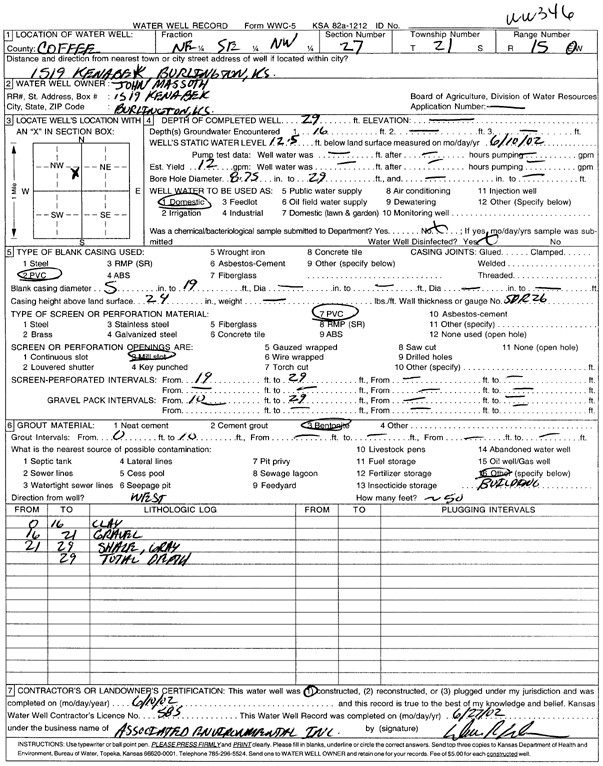
Massoth, John | 29 ft. | 12.5 ft. | 12 gpm. | Domestic | WW 346 | Constructed | 10-Jun-2002 | Scan |
|
T21S, R15E, Sec. 27 NE NE SE |
McGee, James | 21 ft. | Monitoring well/observation/piezometer | MW 7 R | Constructed | 17-Jun-2008 | |||
|
T21S, R15E, Sec. 27 NE NE SE |
McGee, James | 21 ft. | Monitoring well/observation/piezometer | MW 9 | Constructed | 17-Jun-2008 | |||
|
T21S, R15E, Sec. 27 NW NW SE |
Scharffe, Herald | 65 ft. | 7 ft. | Irrigation | Constructed | 01-Jul-1989 | |||
|
T21S, R15E, Sec. 27 SE SE NE |
Smitty's Apco | 18 ft. | 16.25 ft. | Monitoring well/observation/piezometer | MW 4 | Constructed | 29-Jan-1997 | ||
|
T21S, R15E, Sec. 27 NE NE SE |
Smitty's Apco | 20 ft. | 17.7 ft. | Monitoring well/observation/piezometer | MW 7 | Constructed | 29-Jan-1997 | ||
|
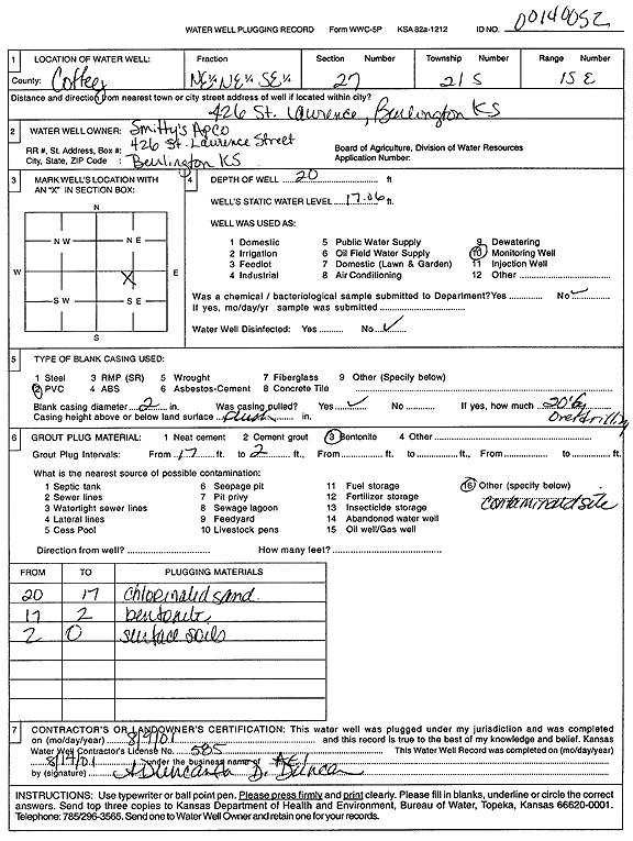
T21S, R15E, Sec. 27 NE NE SE |
Smitty's Apco | 20 ft. | 17.06 ft. | Monitoring well/observation/piezometer | Plugged | 09-Aug-2001 | Scan | ||
|
T21S, R15E, Sec. 27 SE SE NE |
Smitty's Apco | 13 ft. | 11.22 ft. | Monitoring well/observation/piezometer | MW 2 | Constructed | 29-Jan-1997 | ||
|
T21S, R15E, Sec. 27 SE SE NE |
Smitty's Apco | 13.5 ft. | 13.23 ft. | Monitoring well/observation/piezometer | MW 3 | Constructed | 29-Jan-1997 | ||
|
T21S, R15E, Sec. 27 SE SE NE |
Smitty's Apco | 13 ft. | 11.54 ft. | Monitoring well/observation/piezometer | MW 1 | Constructed | 29-Jan-1997 | ||
|
T21S, R15E, Sec. 27 SE SE NE |
Smitty's Apco | 12 ft. | Monitoring well/observation/piezometer | MW 5 | Constructed | 29-Jan-1997 | |||
|
T21S, R15E, Sec. 27 SE NE SE |
United Oil | 10 ft. | 2.13 ft. | Monitoring well/observation/piezometer | MW 6 | Constructed | 20-Mar-1997 | ||
|
T21S, R15E, Sec. 27 SE NE SE |
United Oil | 9.5 ft. | 2.81 ft. | Monitoring well/observation/piezometer | MW 9 | Constructed | 20-Mar-1997 | ||
|
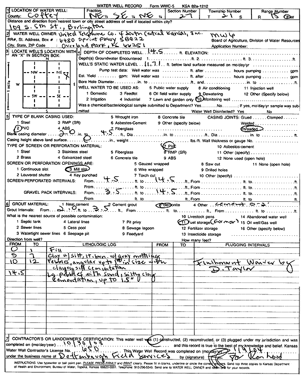
T21S, R15E, Sec. 27 NE SE NE |
United Telephone Co. of S Central Kansas, Inc. | 18.3 ft. | Monitoring well/observation/piezometer | MW 2 | Plugged | 09-Jun-2010 | |||
|
T21S, R15E, Sec. 27 NE SE NE |
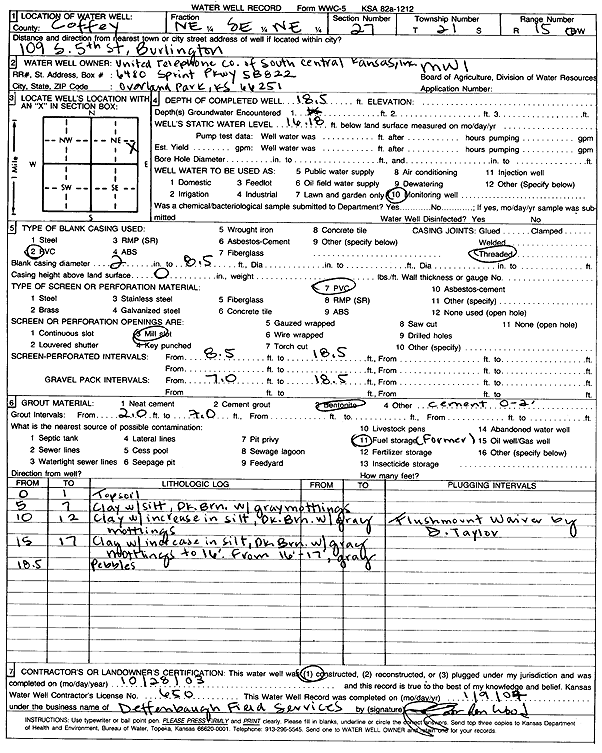
United Telephone Co. of S Central Kansas, Inc. | 19.9 ft. | Monitoring well/observation/piezometer | MW 5 | Plugged | 09-Jun-2010 | |||
|
T21S, R15E, Sec. 27 NE SE NE |
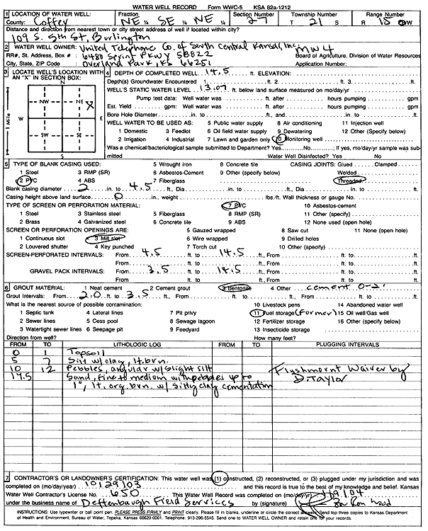
United Telephone Co. of S Central Kansas, Inc. | 14.5 ft. | 13.07 ft. | Monitoring well/observation/piezometer | MW 4 | Constructed | 29-Oct-2003 | Scan | |
|
T21S, R15E, Sec. 27 NE SE NE |
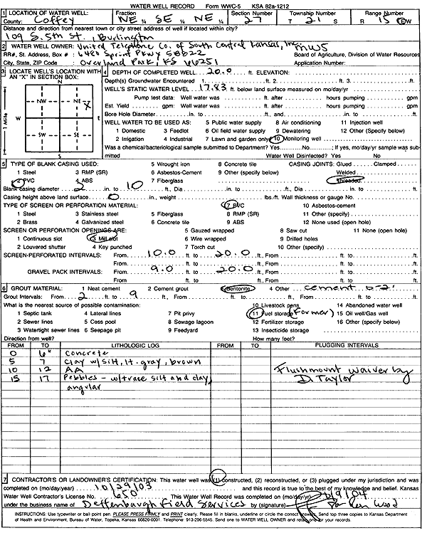
United Telephone Co. of S Central Kansas, Inc. | 20 ft. | 17.83 ft. | Monitoring well/observation/piezometer | MW 5 | Constructed | 29-Oct-2003 | Scan | |
|
T21S, R15E, Sec. 27 NE SE NE |
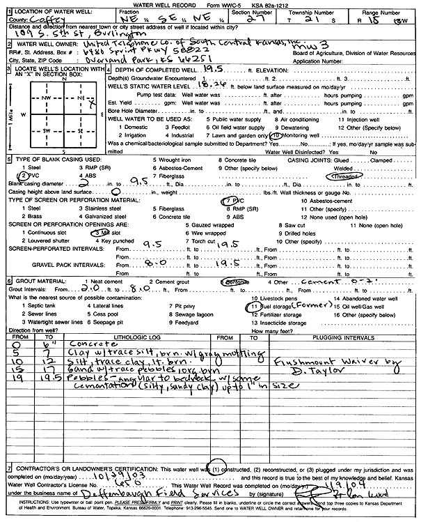
United Telephone Co. of S Central Kansas, Inc. | 19.5 ft. | 18.26 ft. | Monitoring well/observation/piezometer | MW 3 | Constructed | 29-Oct-2003 | Scan | |
|
T21S, R15E, Sec. 27 NE SE NE |
United Telephone Co. of S Central Kansas, Inc. | 18.5 ft. | 16.18 ft. | Monitoring well/observation/piezometer | MW 1 | Constructed | 28-Oct-2003 | Scan | |
|
T21S, R15E, Sec. 27 NE SE NE |
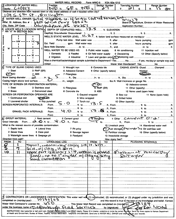
United Telephone Co. of S Central Kansas, Inc. | 13.5 ft. | 11.27 ft. | Monitoring well/observation/piezometer | MW 7 | Constructed | 30-Oct-2003 | Scan | |
|
T21S, R15E, Sec. 27 NE SE NE |
United Telephone Co. of S Central Kansas, Inc. | 18.5 ft. | Monitoring well/observation/piezometer | MW 1 | Plugged | 09-Jun-2010 | |||
|
T21S, R15E, Sec. 27 NE SE NE |
United Telephone Co. of S Central Kansas, Inc. | 12.9 ft. | Monitoring well/observation/piezometer | MW 7 | Plugged | 09-Jun-2010 | |||
|
T21S, R15E, Sec. 27 NE SE NE |
United Telephone Co. of S Central Kansas, Inc. | 13.8 ft. | Monitoring well/observation/piezometer | MW 6 | Plugged | 09-Jun-2010 | |||
|
T21S, R15E, Sec. 27 NE SE NE |
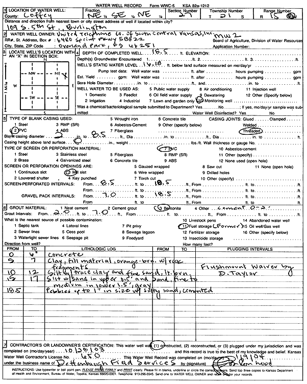
United Telephone Co. of S Central Kansas, Inc. | 18.5 ft. | 16.18 ft. | Monitoring well/observation/piezometer | MW 2 | Constructed | 28-Oct-2003 | Scan | |
|
T21S, R15E, Sec. 27 NE SE NE |
United Telephone Co. of S Central Kansas, Inc. | 14.5 ft. | 11.71 ft. | Monitoring well/observation/piezometer | MW 6 | Constructed | 30-Oct-2003 | Scan | |
|
T21S, R15E, Sec. 27 NE SE NE |
United Telephone Co. of S Central Kansas, Inc. | 13.8 ft. | Monitoring well/observation/piezometer | MW 4 | Plugged | 09-Jun-2010 | |||
|
T21S, R15E, Sec. 27 NE SE NE |
United Telephone Co. of S Central Kansas, Inc. | 19.6 ft. | Monitoring well/observation/piezometer | MW 3 | Plugged | 09-Jun-2010 | |||
|
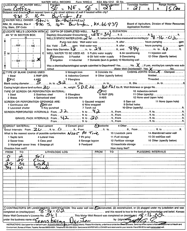
T21S, R15E, Sec. 28 SE NE SE |
Bartholomew, Steve | 60 ft. | 26 ft. | 12 gpm. | Domestic | Constructed | 16-Aug-2002 | Scan | |
|
T21S, R15E, Sec. 28 NE NW SE |
Bull, Jim | 65 ft. | 7.25 ft. | 10 gpm. | Domestic | Constructed | 27-May-1989 | ||
|
T21S, R15E, Sec. 28 NE NE NW |
Hess, Danny | 42 ft. | 9 ft. | 15 gpm. | Domestic | Constructed | 19-Aug-2002 | Scan | |
|
T21S, R15E, Sec. 33 SW SW SW |
Botkin, Danny | 60 ft. | Domestic | Plugged | 07-Jun-2000 | Scan | |||
| View page: 1 || 2 || 3 || 4 || 5 || 6 || 7 || 8 || 9 || 10 || Next > | |||||||||