Select location of well to view details.
Click on column heading to sort.
|
|
|
County: Cowley Select location of well to view details. Click on column heading to sort. |
|
|
|
| View page: < Prev || 21 || 22 || 23 || 24 || 25 || 26 || 27 || 28 || 29 || 30 || Next > | |||||||||
| T-R-S | Owner | Well Depth Ascend. Desc. |
Static Water Level Ascend. Desc. |
Est. Yield Ascend. Desc. |
Well Use | Other ID | Action Taken | Completion Date Ascend. Desc. |
Scan? |
|
T33S, R4E, Sec. 19 NW SE NW |
General Electric Co. | 20 ft. | 10.51 ft. | Monitoring well/observation/piezometer | DM 8 | Constructed | 23-May-1984 | Scan | |
|
T33S, R4E, Sec. 19 SE NW SE |
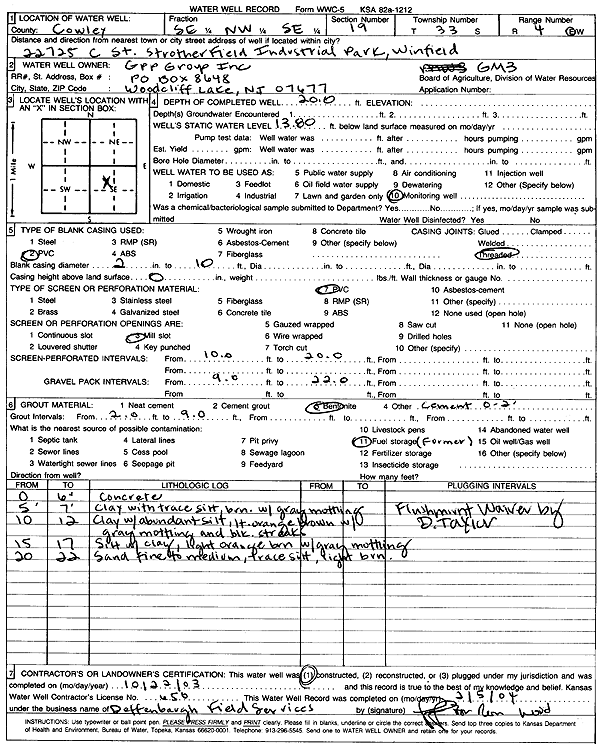
GPP Group, Inc. | 20 ft. | 13.8 ft. | Monitoring well/observation/piezometer | GM 3 | Constructed | 22-Oct-2003 | Scan | |
|
T33S, R4E, Sec. 19 SE NW SE |
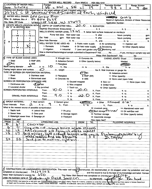
GPP Group, Inc. | 20 ft. | 13.65 ft. | Monitoring well/observation/piezometer | GM 6 | Constructed | 24-Oct-2003 | Scan | |
|
T33S, R4E, Sec. 19 SE NW SE |
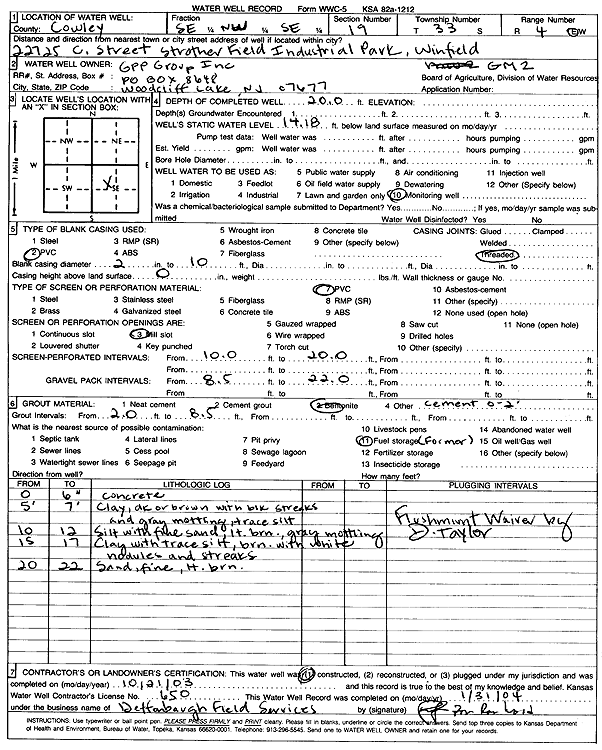
GPP Group, Inc. | 20 ft. | 14.18 ft. | Monitoring well/observation/piezometer | GM 2 | Constructed | 21-Oct-2003 | Scan | |
|
T33S, R4E, Sec. 19 SE NW SE |
GPP Group, Inc. | 22 ft. | 13.65 ft. | Monitoring well/observation/piezometer | GM 6 | Plugged | 31-Jan-2006 | ||
|
T33S, R4E, Sec. 19 SE NW SE |
GPP Group, Inc. | 20 ft. | 13.8 ft. | Monitoring well/observation/piezometer | GM 3 | Plugged | 30-Jan-2006 | ||
|
T33S, R4E, Sec. 19 SE NW SE |
GPP Group, Inc. | 23 ft. | 15.96 ft. | Monitoring well/observation/piezometer | GM 5 | Plugged | 31-Jan-2006 | ||
|
T33S, R4E, Sec. 19 SE NW SE |
GPP Group, Inc. | 20 ft. | 14 ft. | Monitoring well/observation/piezometer | GM 4 | Plugged | 31-Jan-2006 | ||
|
T33S, R4E, Sec. 19 SE NW SE |
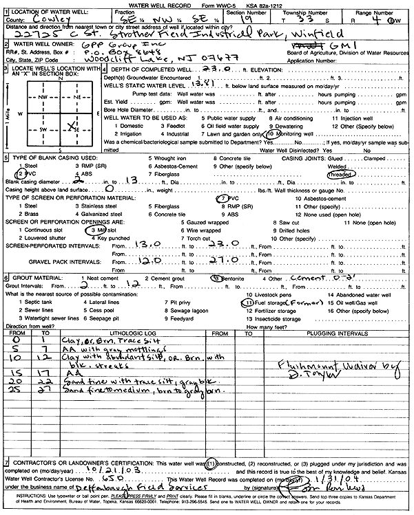
GPP Group, Inc. | 27 ft. | 13.81 ft. | Monitoring well/observation/piezometer | GM 1 | Plugged | 31-Jan-2006 | ||
|
T33S, R4E, Sec. 19 SE NW SE |
GPP Group, Inc. | 22 ft. | 14.18 ft. | Monitoring well/observation/piezometer | GM 2 | Plugged | 31-Jan-2006 | ||
|
T33S, R4E, Sec. 19 SE NW SE |
GPP Group, Inc. | 23 ft. | 13.81 ft. | Monitoring well/observation/piezometer | GM 1 | Constructed | 21-Oct-2003 | Scan | |
|
T33S, R4E, Sec. 19 SE NW SE |
GPP Group, Inc. | 20 ft. | 14 ft. | Monitoring well/observation/piezometer | GM 4 | Constructed | 22-Oct-2003 | Scan | |
|
T33S, R4E, Sec. 19 SE NW SE |
GPP Group, Inc. | 23 ft. | 15.96 ft. | Monitoring well/observation/piezometer | GM 5 | Constructed | 23-Oct-2003 | Scan | |
|
T33S, R4E, Sec. 19 NW NE SE |
Greif Bros | 33 ft. | 7.13 ft. | Monitoring well/observation/piezometer | GGP 3 | Constructed | 21-Sep-1988 | ||
|
T33S, R4E, Sec. 19 SE NW SE |
Greif Bros | 43 ft. | 18.7 ft. | Monitoring well/observation/piezometer | MW GB 1 | Constructed | 06-Dec-1993 | ||
|
T33S, R4E, Sec. 19 NE NW SE |
Greif Bros | 43 ft. | 17.73 ft. | Monitoring well/observation/piezometer | GGP 1 | Constructed | 21-Sep-1988 | ||
|
T33S, R4E, Sec. 19 NE NW SE |
Greif Bros | 45.5 ft. | 16.6 ft. | Monitoring well/observation/piezometer | GGP 2 | Constructed | 21-Sep-1988 | ||
|
T33S, R4E, Sec. 19 SE NW SE |
Greif Bros | 43 ft. | 17.84 ft. | Monitoring well/observation/piezometer | MW GB 2 | Constructed | 06-Dec-1993 | ||
|
T33S, R4E, Sec. 19 SE SE SE |
Johnson, Lee | 38 ft. | 15 ft. | 10 gpm. | Domestic | Constructed | 14-May-1987 | ||
|
T33S, R4E, Sec. 19 SE SE SE |
Jordan, George | 44 ft. | 24 ft. | Domestic | Constructed | 05-Dec-1979 | |||
|
T33S, R4E, Sec. 19 NE SE SE |
KDHE | 39 ft. | 18.4 ft. | Monitoring well/observation/piezometer | MW 1 | Constructed | 01-Sep-1992 | ||
|
T33S, R4E, Sec. 19 NE NW SE |
KDHE | 36 ft. | 11.2 ft. | Monitoring well/observation/piezometer | MW 3 A 86 | Constructed | 14-Jul-1986 | ||
|
T33S, R4E, Sec. 19 NE NW SE |
KDHE | 43.6 ft. | Monitoring well/observation/piezometer | MW 10 A 86 | Constructed | 04-Aug-1986 | |||
|
T33S, R4E, Sec. 19 NW NW SE |
KDHE | 23.5 ft. | 16 ft. | Monitoring well/observation/piezometer | MW 4 B 86 | Constructed | 16-Jul-1986 | ||
|
T33S, R4E, Sec. 19 NE SE NE |
KDHE | 38.7 ft. | 14.1 ft. | Monitoring well/observation/piezometer | MW 11 A 86 | Plugged | 05-Sep-1989 | ||
|
T33S, R4E, Sec. 19 SE SE NE |
KDHE | 36 ft. | 9.4 ft. | Monitoring well/observation/piezometer | MW 10 | Constructed | 26-May-1994 | ||
|
T33S, R4E, Sec. 19 NE SE SE |
KDHE | 39.5 ft. | 17.1 ft. | Monitoring well/observation/piezometer | MW 2 | Constructed | 01-Sep-1992 | ||
|
T33S, R4E, Sec. 19 SE SE NE |
KDHE | 38 ft. | 11.03 ft. | Monitoring well/observation/piezometer | MW 6 | Constructed | 25-May-1994 | ||
|
T33S, R4E, Sec. 19 SE SE NE |
KDHE | 37 ft. | 10.04 ft. | Monitoring well/observation/piezometer | MW 7 | Constructed | 24-May-1994 | ||
|
T33S, R4E, Sec. 19 NE NE SW |
KDHE | 40.5 ft. | Monitoring well/observation/piezometer | MW 6 A 86 | Constructed | 23-Jul-1986 | |||
|
T33S, R4E, Sec. 19 SE SE NE |
KDHE | 36 ft. | 9 ft. | Monitoring well/observation/piezometer | MW 9 | Constructed | 26-May-1994 | ||
|
T33S, R4E, Sec. 19 NE SW NE |
KDHE | 36.5 ft. | Monitoring well/observation/piezometer | MW 9 A 86 | Constructed | 30-Jul-1986 | |||
|
T33S, R4E, Sec. 19 NE SW NE |
KDHE | 22.4 ft. | Monitoring well/observation/piezometer | MW 9 B 86 | Constructed | 30-Jul-1986 | |||
|
T33S, R4E, Sec. 19 SW SW NE |
KDHE | 37 ft. | Monitoring well/observation/piezometer | MW 8 A 86 | Constructed | 29-Jul-1986 | |||
|
T33S, R4E, Sec. 19 SW SW NE |
KDHE | 37.5 ft. | Monitoring well/observation/piezometer | MW 7 A 86 | Constructed | 28-Jul-1986 | |||
|
T33S, R4E, Sec. 19 NE SE NW |
KDHE | 24.5 ft. | Monitoring well/observation/piezometer | MW 11 B 86 | Constructed | 06-Aug-1986 | |||
|
T33S, R4E, Sec. 19 NW NW SE |
KDHE | 40.5 ft. | 15.5 ft. | Monitoring well/observation/piezometer | MW 5 A 86 | Constructed | 21-Jul-1986 | ||
|
T33S, R4E, Sec. 19 NE SE NW |
KDHE | 38.7 ft. | Monitoring well/observation/piezometer | MW 11 A 86 | Constructed | 06-Aug-1986 | |||
|
T33S, R4E, Sec. 19 SE NW SE |
KDHE | 35 ft. | 9.5 ft. | Monitoring well/observation/piezometer | MW 1 A 86 | Constructed | 15-Jul-1986 | ||
|
T33S, R4E, Sec. 19 SE NW SE |
KDHE | 42 ft. | Monitoring well/observation/piezometer | MW 2 A 86 | Constructed | 21-Jul-1986 | |||
|
T33S, R4E, Sec. 19 NW NW SE |
KDHE | 40 ft. | 16 ft. | Monitoring well/observation/piezometer | MW 4 A 86 | Constructed | 16-Jul-1986 | ||
|
T33S, R4E, Sec. 19 NE SE SE |
KDHE | 42.5 ft. | 20.1 ft. | Monitoring well/observation/piezometer | MW 5 | Constructed | 02-Sep-1992 | ||
|
T33S, R4E, Sec. 19 NE SE NW |
KDHE | 24.5 ft. | 14.1 ft. | Monitoring well/observation/piezometer | MW 11 B 86 | Plugged | 05-Sep-1989 | ||
|
T33S, R4E, Sec. 19 SE SE NE |
KDHE | 37 ft. | 9.52 ft. | Monitoring well/observation/piezometer | MW 8 | Constructed | 26-May-1994 | ||
|
T33S, R4E, Sec. 19 SW SW NE |
KDHE | 37 ft. | 12.83 ft. | Monitoring well/observation/piezometer | MW 8 A | Plugged | 21-Feb-1990 | ||
|
T33S, R4E, Sec. 19 NE NW NE |
Kone Inc. | 20 ft. | Monitoring well/observation/piezometer | MW 1 | Constructed | 27-Oct-2000 | Scan | ||
|
T33S, R4E, Sec. 19 SE SE SE |
McClure, Gary | 50 ft. | 20 ft. | 87.5 gpm. | Domestic | Constructed | 30-Jul-1986 | ||
|
T33S, R4E, Sec. 19 SW NE |
Seacat Trust | 70 ft. | 30 ft. | Domestic, Lawn and Garden | Plugged | 26-Jan-2011 | |||
|
T33S, R4E, Sec. 19 SW NE SE |
Strother Field Commission | 33 ft. | 7.06 ft. | Monitoring well/observation/piezometer | ST 3 | Constructed | 11-Mar-1997 | ||
|
T33S, R4E, Sec. 19 SW SE NE |
Strother Field Commission | 34.5 ft. | 16.57 ft. | Monitoring well/observation/piezometer | RI 6 | Plugged | 11-Feb-1993 | ||
| View page: < Prev || 21 || 22 || 23 || 24 || 25 || 26 || 27 || 28 || 29 || 30 || Next > | |||||||||