Select location of well to view details.
Click on column heading to sort.
|
|
|
County: Cowley Select location of well to view details. Click on column heading to sort. |
|
|
|
| View page: < Prev || 21 || 22 || 23 || 24 || 25 || 26 || 27 || 28 || 29 || 30 || Next > | |||||||||
| T-R-S | Owner | Well Depth Ascend. Desc. |
Static Water Level Ascend. Desc. |
Est. Yield Ascend. Desc. |
Well Use | Other ID | Action Taken | Completion Date Ascend. Desc. |
Scan? |
|
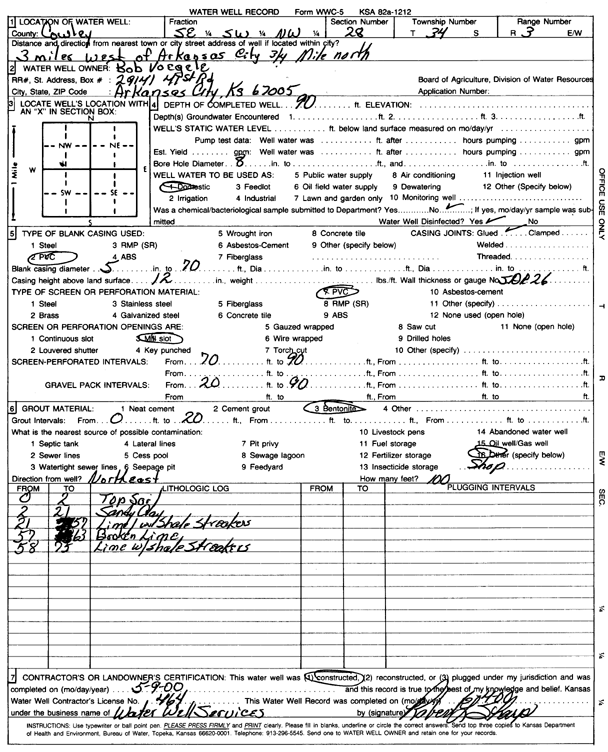
T34S, R3E, Sec. 28 SE SW NE |
Voegele, Bob | 90 ft. | Domestic | Constructed | 09-May-2000 | Scan | |||
|
T34S, R3E, Sec. 32 NE NW SW |
MWH Americas Inc | 41 ft. | 26.14 ft. | Monitoring well/observation/piezometer | B 108 R | Constructed | 17-Sep-2004 | ||
|
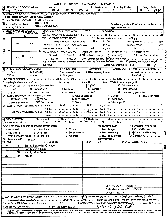
T34S, R3E, Sec. 32 SE NE SW |
Total Petroleum Inc. | 32.5 ft. | Monitoring well/observation/piezometer | CMW 2 | Constructed | 19-Nov-1999 | Scan | ||
|
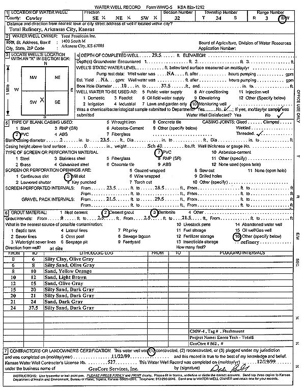
T34S, R3E, Sec. 32 SE NE SW |
Total Petroleum Inc. | 29.5 ft. | Monitoring well/observation/piezometer | CMW 4 | Constructed | 22-Nov-1999 | Scan | ||
|
T34S, R3E, Sec. 32 NE NW SW |
Total Petroleum Inc. | 52.8 ft. | Monitoring well/observation/piezometer | B 108 | Plugged | 16-Sep-2004 | |||
|
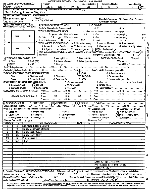
T34S, R3E, Sec. 32 SE NE SW |
Total Petroleum Inc. | 32 ft. | Monitoring well/observation/piezometer | CMW 3 | Constructed | 01-Dec-1999 | Scan | ||
|
T34S, R3E, Sec. 32 NE NW SW |
Total Petroleum Inc. | 52.8 ft. | 23.94 ft. | Monitoring well/observation/piezometer | B 108 | Constructed | 15-Apr-1998 | ||
|
T34S, R3E, Sec. 32 NE NW SW |
Total Petroleum Inc. | 30 ft. | 21.29 ft. | Monitoring well/observation/piezometer | B 109 | Constructed | 15-Apr-1998 | ||
|
T34S, R3E, Sec. 32 NE NW SW |
Total Petroleum Inc. | 30 ft. | 13.95 ft. | Monitoring well/observation/piezometer | B 110 | Constructed | 15-Apr-1998 | ||
|
T34S, R3E, Sec. 32 NE NW SW |
Total Petroleum Inc. | 52 ft. | 22.18 ft. | Monitoring well/observation/piezometer | B 107 | Constructed | 15-Apr-1998 | ||
|
T34S, R3E, Sec. 32 NE NW SW |
Total Petroleum Inc. | 34 ft. | 25.94 ft. | Monitoring well/observation/piezometer | B 10 | Constructed | 08-Oct-1997 | ||
|
T34S, R3E, Sec. 32 NE NW SW |
Total Petroleum Inc. | 27 ft. | 16.16 ft. | Monitoring well/observation/piezometer | A 1 | Constructed | 06-Oct-1997 | ||
|
T34S, R3E, Sec. 32 NE NW SW |
Total Petroleum Inc. | 32 ft. | 23.87 ft. | Monitoring well/observation/piezometer | B 2 | Constructed | 08-Oct-1997 | ||
|
T34S, R3E, Sec. 32 NE NW SW |
Total Petroleum Inc. | 30 ft. | 20.14 ft. | Monitoring well/observation/piezometer | B 6 | Constructed | 08-Oct-1997 | ||
|
T34S, R3E, Sec. 32 NE NW SW |
Total Petroleum Inc. | 32 ft. | Monitoring well/observation/piezometer | B 7 | Constructed | 09-Oct-1997 | |||
|
T34S, R3E, Sec. 32 NE NW SW |
Total Petroleum Inc. | 34 ft. | 25.78 ft. | Monitoring well/observation/piezometer | B 8 | Constructed | 07-Oct-1997 | ||
|
T34S, R3E, Sec. 32 NE NW SW |
Total Petroleum Inc. | 34 ft. | 26.38 ft. | Monitoring well/observation/piezometer | B 9 | Constructed | 09-Oct-1997 | ||
|
T34S, R3E, Sec. 32 NE NW SW |
Total Petroleum Inc. | 28.5 ft. | 13.21 ft. | Monitoring well/observation/piezometer | B 112 | Constructed | 16-Apr-1998 | ||
|
T34S, R3E, Sec. 32 NE NW SW |
Total Petroleum Inc. | 40 ft. | 24.78 ft. | Monitoring well/observation/piezometer | B 113 | Constructed | 16-Apr-1998 | ||
|
T34S, R3E, Sec. 32 NE NW SW |
Total Petroleum Inc. | 33 ft. | 23.38 ft. | Monitoring well/observation/piezometer | B 114 | Constructed | 16-Apr-1998 | ||
|
T34S, R3E, Sec. 32 NE NW SW |
TPI Petroleum Inc | 41 ft. | 26.14 ft. | Monitoring well/observation/piezometer | B 108 R | Constructed | 17-Sep-2004 | ||
|
T34S, R3E, Sec. 33 SE NW SW SE |
Grainland Farms, Inc. | 80 ft. | 34 ft. | 400 gpm. | Other
(Irrigation Test well) |
Constructed | 22-Sep-2021 |
KOLAR |
|
|
T34S, R3E, Sec. 33 NE NW NW |
Metzinger, Jim | 62 ft. | 17 ft. | 75 gpm. | Domestic | Constructed | 10-Nov-1984 | ||
|
T34S, R3E, Sec. 33 SW SW SE |
Shurtz, Dennis | 90 ft. | 25 ft. | 400 gpm. | Monitoring well/observation/piezometer | Constructed | 18-Jan-2024 |
KOLAR |
|
|
T34S, R3E, Sec. 33 NW SW SE |
Shurtz, Dennis | 90 ft. | 24 ft. | 400 gpm. | Monitoring well/observation/piezometer | Constructed | 18-Jan-2024 |
KOLAR |
|
|
T34S, R3E, Sec. 33 NW SW SE |
Shurtz, Dennis | 75 ft. | 45 ft. | Test hole/well | Plugged | 20-Dec-2024 |
KOLAR |
||
|
T34S, R3E, Sec. 33 SE SE SW |
Shurtz, Dennis | 87 ft. | 27 ft. | Test hole/well | Plugged | 20-Dec-2024 |
KOLAR |
||
|
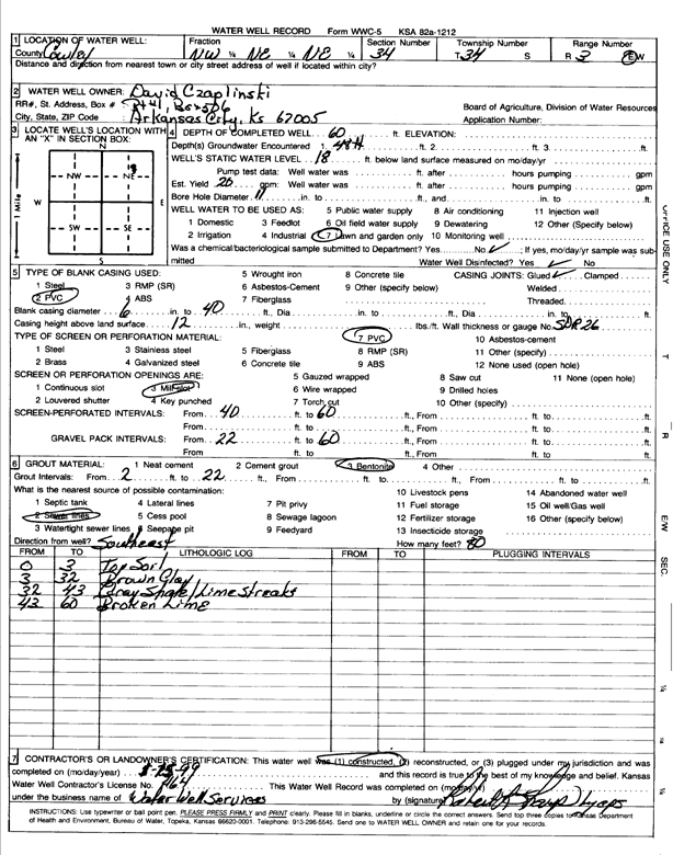
T34S, R3E, Sec. 34 NW NE NE |
Czaplinski, David | 60 ft. | 18 ft. | 20 gpm. | Domestic, Lawn and Garden | Constructed | 25-Jan-1999 | Scan | |
|
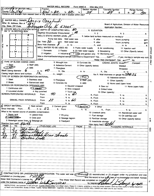
T34S, R3E, Sec. 34 NW NE NE |
Czaplinski, Dennis | 60 ft. | 15 ft. | 20 gpm. | Domestic, Lawn and Garden | Constructed | 22-Jan-1999 | Scan | |
|
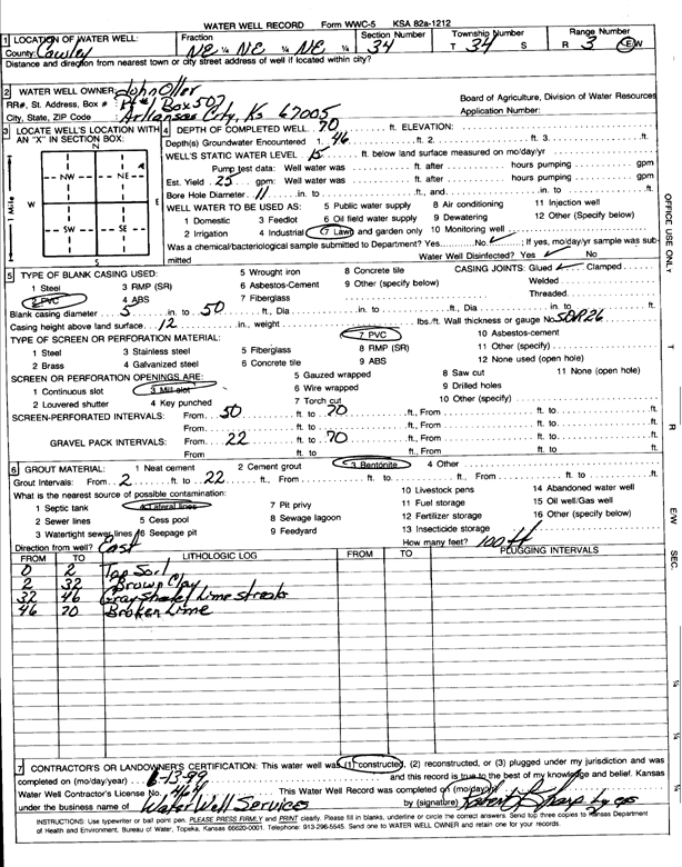
T34S, R3E, Sec. 34 NE NE NE |
Oller, John | 70 ft. | 15 ft. | 25 gpm. | Domestic, Lawn and Garden | Constructed | 13-Jun-1999 | Scan | |
|
T34S, R3E, Sec. 34 SE SE SE |
Ysidro, Alejandro | 120 ft. | 34 ft. | 7 gpm. | Domestic, Lawn and Garden | Constructed | 15-Aug-2025 |
KOLAR |
|
|
T34S, R3E, Sec. 35 NE NE NE |
KDHE | 32.2 ft. | 5.9 ft. | Monitoring well/observation/piezometer | Well 4 | Constructed | 15-Jun-1982 | ||
|
T34S, R3E, Sec. 35 SW NW NW |
Mills, Rod | 200 ft. | Geothermal, Closed Loop, Vertical | Constructed | 14-May-2014 | ||||
|
T34S, R3E, Sec. 35 NW NW NE |
Mills, Rod | 200 ft. | Geothermal, Closed Loop, Vertical | Constructed | 15-Jan-2014 | ||||
|
T34S, R3E, Sec. 35 SE NW NW |
Sumner County RWD 4 | 28 ft. | 8 ft. | Public Water Supply | Plugged | 09-Jun-1988 | |||
|
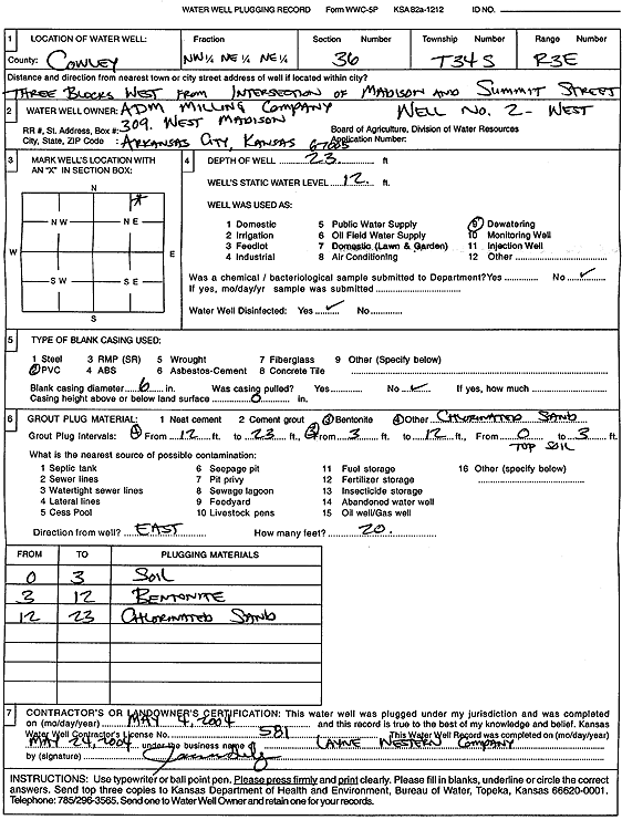
T34S, R3E, Sec. 36 NW NE NE |
ADM Milling Company | 23 ft. | 12 ft. | Dewatering | Well 2 W | Plugged | 04-May-2004 | Scan | |
|
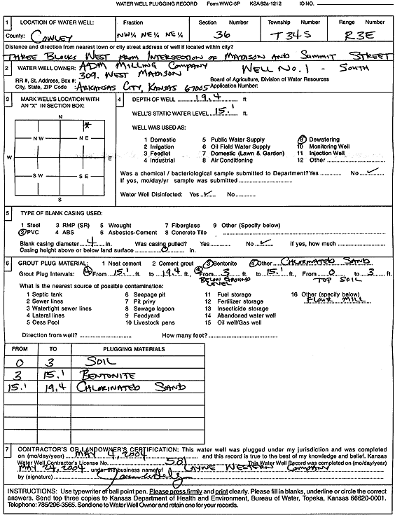
T34S, R3E, Sec. 36 NW NE NE |
ADM Milling Company | 19.4 ft. | 15 ft. | Dewatering | Well 1 S | Plugged | 04-May-2004 | Scan | |
|
T34S, R3E, Sec. 36 S2 SE SW |
Barton, Chester | 40 ft. | 7 ft. | Domestic, Lawn and Garden | Constructed | 24-Jun-1996 | |||
|
T34S, R3E, Sec. 36 NW NW SE |
City of Arkansas City | 43.4 ft. | 16.3 ft. | (unstated)/abandoned | Well 1 S | Plugged | 23-Jan-2007 | ||
|
T34S, R3E, Sec. 36 SE NW NW |
City of Arkansas City | 18 ft. | 15 ft. | Monitoring well/observation/piezometer | Constructed | 02-Dec-1986 | |||
|
T34S, R3E, Sec. 36 NW NW SE |
City of Arkansas City | 38.4 ft. | 16.1 ft. | (unstated)/abandoned | Well 3 East | Plugged | 23-Jan-2007 | ||
|
T34S, R3E, Sec. 36 NW NW SE |
City of Arkansas City | 40.92 ft. | 15.9 ft. | (unstated)/abandoned | Well 2 W | Plugged | 23-Jan-2007 | ||
|
T34S, R3E, Sec. 36 SE NW NW |
City of Arkansas City | 18 ft. | 15 ft. | Monitoring well/observation/piezometer | Constructed | 02-Dec-1986 | |||
|
T34S, R3E, Sec. 36 NE NW SE |
City of Arkansas City | 26 ft. | 10 ft. | 100 gpm. | Domestic, Livestock | Constructed | 02-Nov-2000 | ||
|
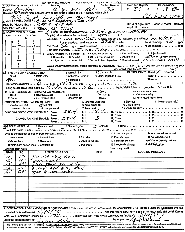
T34S, R3E, Sec. 36 W2 NW NW |
Corps of Engineers, Tulsa Dist. | 28.4 ft. | 23.5 ft. | Other | Relief Well 81+40 | Constructed | 01-Dec-2000 | Scan | |
|
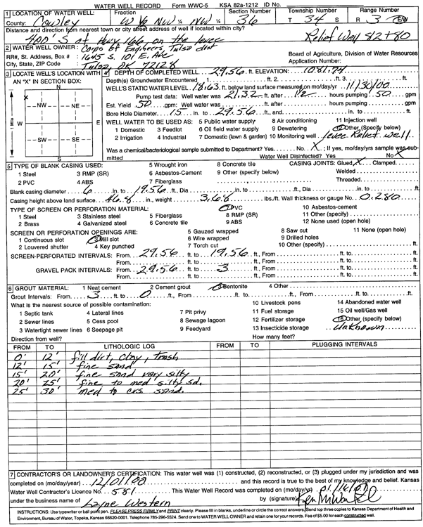
T34S, R3E, Sec. 36 W2 NW NW |
Corps of Engineers, Tulsa Dist. | 29.56 ft. | 18.63 ft. | 50 gpm. | Other | Relief Well 82+80 | Constructed | 01-Dec-2000 | Scan |
|
T34S, R3E, Sec. 36 W2 NW NW |
Corps of Engineers, Tulsa Dist. | 30.73 ft. | 22.35 ft. | 50 gpm. | Other | Relief Well 79+30 | Constructed | 01-Dec-2000 | Scan |
|
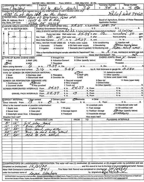
T34S, R3E, Sec. 36 W2 NW NW |
Corps of Engineers, Tulsa Dist. | 29.37 ft. | 22.22 ft. | 50 gpm. | Other | Relief Well 79+60 | Constructed | 01-Dec-2000 | Scan |
|
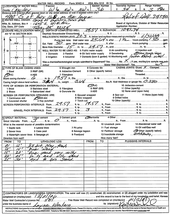
T34S, R3E, Sec. 36 W2 NW NW |
Corps of Engineers, Tulsa Dist. | 29.57 ft. | 22.3 ft. | 50 gpm. | Other | Relief Well 79+90 | Constructed | 01-Dec-2000 | Scan |
|
T34S, R3E, Sec. 36 W2 NW NW |
Corps of Engineers, Tulsa Dist. | 29.55 ft. | 19.3 ft. | 50 gpm. | Other | Relief Well 80+20 | Constructed | 01-Dec-2000 | Scan |
| View page: < Prev || 21 || 22 || 23 || 24 || 25 || 26 || 27 || 28 || 29 || 30 || Next > | |||||||||