Select location of well to view details.
Click on column heading to sort.
|
|
|
County: Decatur Select location of well to view details. Click on column heading to sort. |
|
|
|
| View page: < Prev || 11 || 12 || 13 || 14 || 15 || 16 || 17 || 18 || 19 || 20 || Next > | |||||||||
| T-R-S | Owner | Well Depth Ascend. Desc. |
Static Water Level Ascend. Desc. |
Est. Yield Ascend. Desc. |
Well Use | Other ID | Action Taken | Completion Date Ascend. Desc. |
Scan? |
|
T3S, R29W, Sec. 1 SE NW SW |
City of Oberlin | 35 ft. | 0 ft. | Monitoring well/observation/piezometer | PPW 1 | Constructed | 15-Dec-1993 | ||
|
T3S, R29W, Sec. 1 SE NW SW |
City of Oberlin | 16 ft. | Environmental Remediation, Soil Vapor Extraction | SVE A | Constructed | 10-Apr-1996 | |||
|
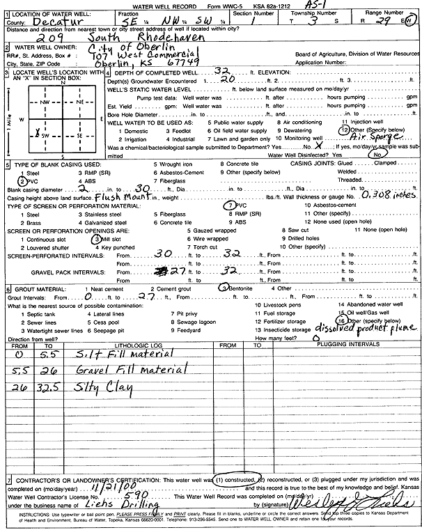
T3S, R29W, Sec. 1 SE NW SW |
City of Oberlin | 32 ft. | Environmental Remediation, Air Sparge | AS 1 | Constructed | 21-Nov-2000 | Scan | ||
|
T3S, R29W, Sec. 1 SE NW SW |
City of Oberlin | 43 ft. | 25.71 ft. | Monitoring well/observation/piezometer | Constructed | 08-Jan-1993 | |||
|
T3S, R29W, Sec. 1 SE NW SW |
City of Oberlin | 34 ft. | Monitoring well/observation/piezometer | OBW 1 | Constructed | 14-Dec-1993 | |||
|
T3S, R29W, Sec. 1 SE NW SW |
City of Oberlin | 35 ft. | 27.07 ft. | Monitoring well/observation/piezometer | MW 4 | Constructed | 06-Jan-1993 | ||
|
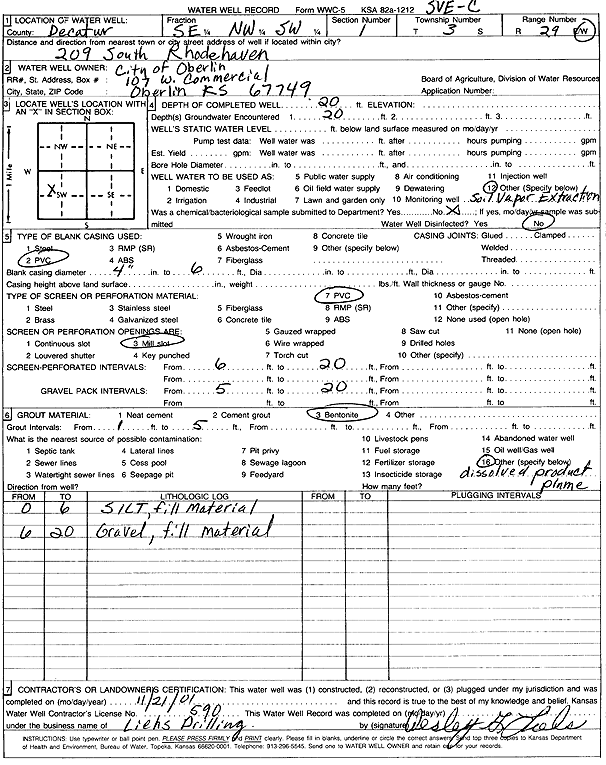
T3S, R29W, Sec. 1 SE NW SW |
City of Oberlin | 20 ft. | Environmental Remediation, Soil Vapor Extraction | SVE C | Constructed | 21-Nov-2000 | Scan | ||
|
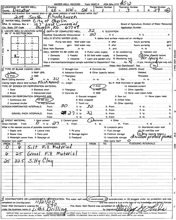
T3S, R29W, Sec. 1 SE NW SW |
City of Oberlin | 32 ft. | Environmental Remediation, Air Sparge | AS 2 | Constructed | 21-Nov-2000 | Scan | ||
|
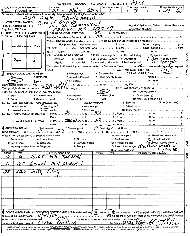
T3S, R29W, Sec. 1 SE NW SW |
City of Oberlin | 32 ft. | Environmental Remediation, Air Sparge | AS 3 | Constructed | 21-Nov-2000 | Scan | ||
|
T3S, R29W, Sec. 1 SE NW SW |
City of Oberlin | 32 ft. | 23 ft. | Environmental Remediation, Air Sparge | AS 4 | Constructed | 26-Apr-2007 | ||
|
T3S, R29W, Sec. 1 SE NW SW |
City of Oberlin | 36.5 ft. | 23 ft. | Environmental Remediation, Air Sparge | AS 5 | Constructed | 26-Apr-2007 | ||
|
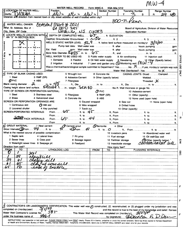
T3S, R29W, Sec. 1 NW NE NW |
Coastal Mart #2521 | 65 ft. | 52.9 ft. | Monitoring well/observation/piezometer | MW 4 | Constructed | 01-Mar-2000 | Scan | |
|
T3S, R29W, Sec. 1 NW NE NW |
Coastal Mart #2521 | 60 ft. | 49.9 ft. | Monitoring well/observation/piezometer | MW 6 | Constructed | 06-Jun-2000 | Scan | |
|
T3S, R29W, Sec. 1 NW NE NW |
Coastal Mart #2521 | 65.5 ft. | 54.96 ft. | Monitoring well/observation/piezometer | MW 5 | Constructed | 05-Jun-2000 | ||
|
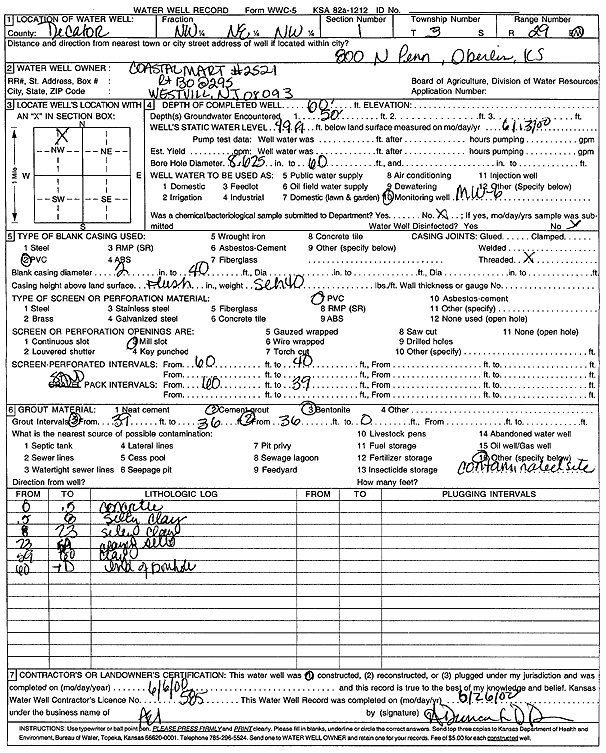
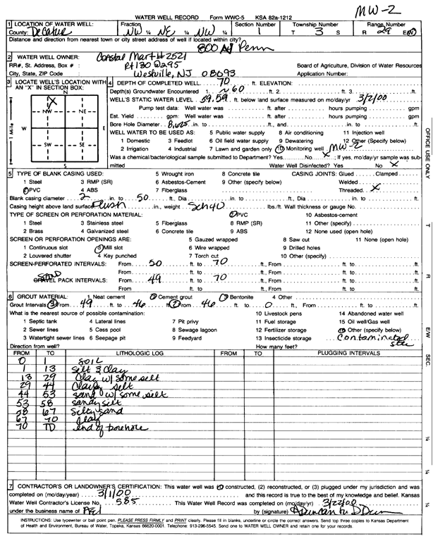
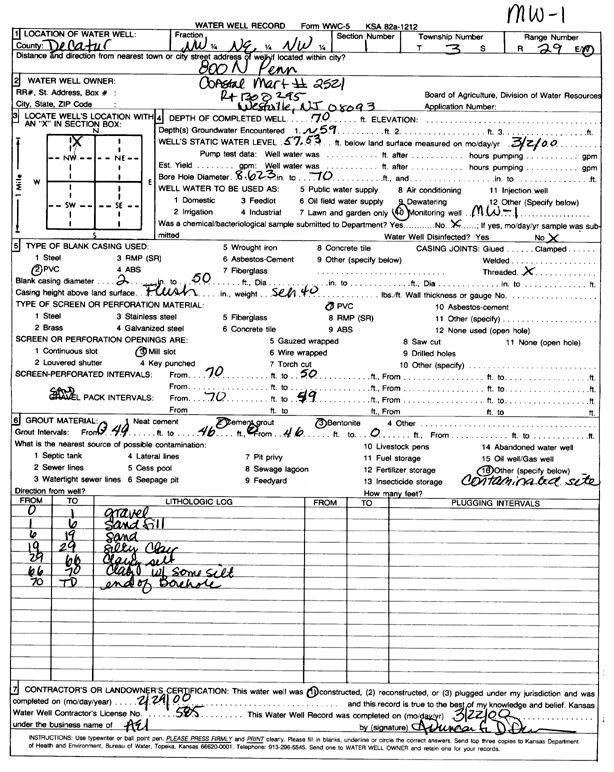
T3S, R29W, Sec. 1 NW NE NW |
Coastal Mart #2521 | 70 ft. | 59.59 ft. | Monitoring well/observation/piezometer | MW 2 | Constructed | 01-Mar-2000 | Scan | |
|
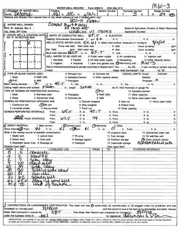
T3S, R29W, Sec. 1 NW NE NW |
Coastal Mart #2521 | 65.5 ft. | 55.61 ft. | Monitoring well/observation/piezometer | MW 3 | Constructed | 28-Feb-2000 | Scan | |
|
T3S, R29W, Sec. 1 NW NE NW |
Coastal Mart #2521 | 70 ft. | 57.53 ft. | Monitoring well/observation/piezometer | MW 1 | Constructed | 29-Feb-2000 | Scan | |
|
T3S, R29W, Sec. 1 NW NE NW |
Coastal Mart #2521 | 65 ft. | Monitoring well/observation/piezometer | MW 8 | Constructed | 07-Jun-2000 | Scan | ||
|
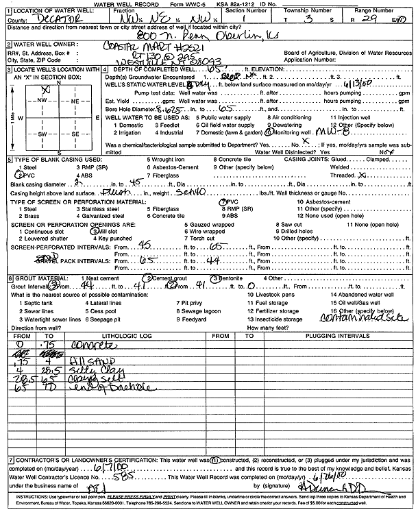
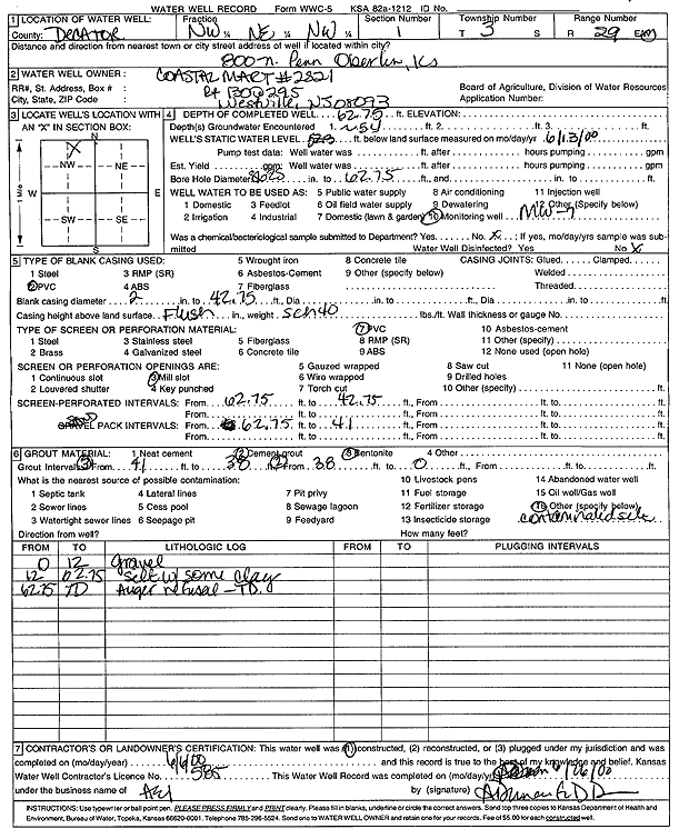
T3S, R29W, Sec. 1 NW NE NW |
Coastal Mart #2521 | 62.75 ft. | 52.3 ft. | Monitoring well/observation/piezometer | MW 7 | Constructed | 06-Jun-2000 | Scan | |
|
T3S, R29W, Sec. 1 NE NE NW SW |
Cundiff, Janice | 35.5 ft. | 21.4 ft. | Monitoring well/observation/piezometer | KMW 14 | Constructed | 13-Dec-2019 | ||
|
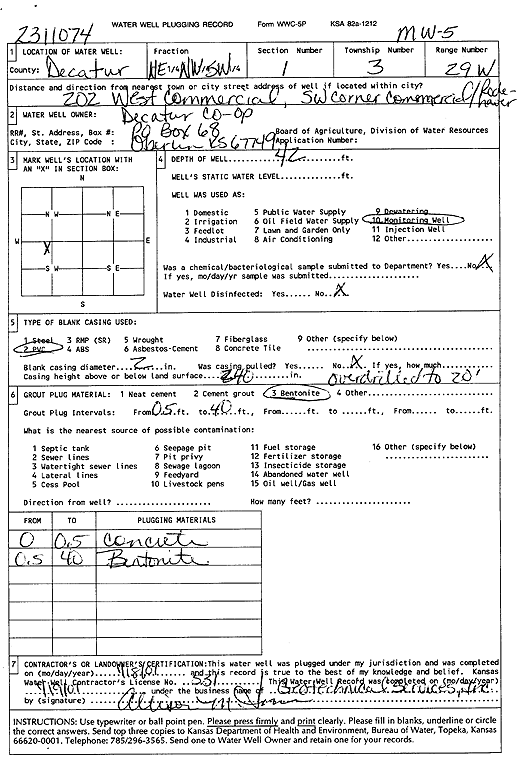
T3S, R29W, Sec. 1 NE NW SW |
Decatur Coop | 42 ft. | Monitoring well/observation/piezometer | MW 5 | Plugged | 18-Jan-2001 | Scan | ||
|
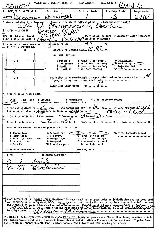
T3S, R29W, Sec. 1 NE NW SW |
Decatur Coop | 37 ft. | 19.92 ft. | Monitoring well/observation/piezometer | RMW-6 | Plugged | 23-May-2000 | Scan | |
|
T3S, R29W, Sec. 1 NE NW SW |
Decatur Coop | 41 ft. | 29 ft. | Monitoring well/observation/piezometer | MW 1 | Constructed | 19-Jul-1993 | ||
|
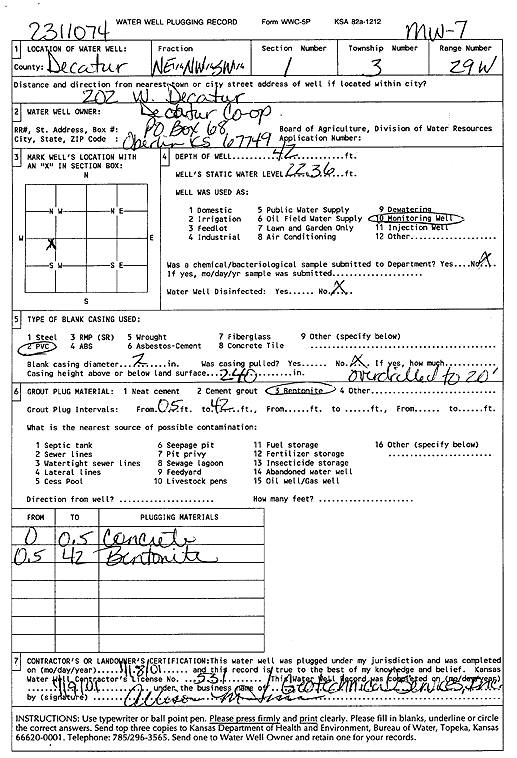
T3S, R29W, Sec. 1 NE NW SW |
Decatur Coop | 42 ft. | 22.36 ft. | Monitoring well/observation/piezometer | MW 7 | Plugged | 18-Jan-2001 | Scan | |
|
T3S, R29W, Sec. 1 NE NW SW |
Decatur Coop | 42 ft. | 29 ft. | Monitoring well/observation/piezometer | MW 7 | Constructed | 21-Jul-1993 | ||
|
T3S, R29W, Sec. 1 NE NW SW |
Decatur Coop | 37 ft. | 29 ft. | Monitoring well/observation/piezometer | MW 6 | Constructed | 21-Jul-1993 | ||
|
T3S, R29W, Sec. 1 NE NW SW |
Decatur Coop | 41 ft. | 29 ft. | Monitoring well/observation/piezometer | MW 2 | Constructed | 19-Jul-1993 | ||
|
T3S, R29W, Sec. 1 NE NW SW |
Decatur Coop | 42 ft. | 29 ft. | Monitoring well/observation/piezometer | MW 3 | Constructed | 20-Jul-1993 | ||
|
T3S, R29W, Sec. 1 NE NW SW |
Decatur Coop | 42 ft. | 29 ft. | Monitoring well/observation/piezometer | MW 5 | Constructed | 20-Jul-1993 | ||
|
T3S, R29W, Sec. 1 NE NW SW |
Decatur Coop | 39.5 ft. | 29 ft. | Monitoring well/observation/piezometer | MW 4 | Constructed | 20-Jul-1993 | ||
|
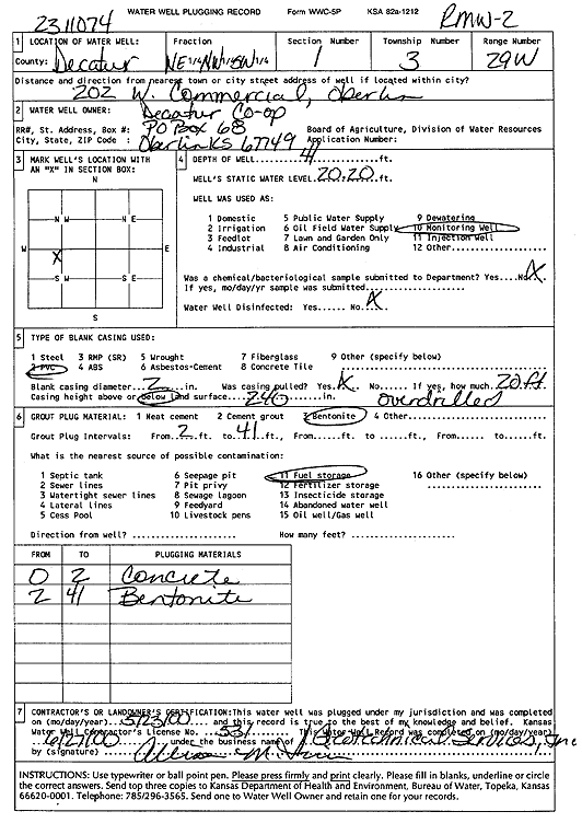
T3S, R29W, Sec. 1 NE NW SW |
Decatur Coop | 41 ft. | 20.2 ft. | Monitoring well/observation/piezometer | RMW-2 | Plugged | 23-May-2000 | Scan | |
|
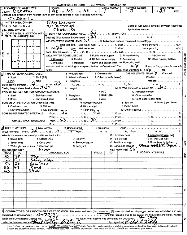
T3S, R29W, Sec. 1 NE NE NE |
Erickson, Gary | 63 ft. | 27 ft. | 20 gpm. | Domestic | Constructed | 20-Apr-2001 | Scan | |
|
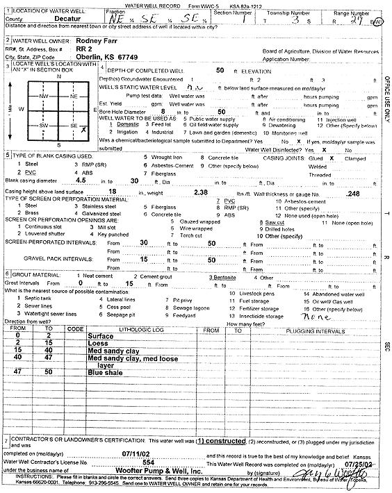
T3S, R29W, Sec. 1 NE SE SE |
Farr, Rodney | 50 ft. | Domestic | Constructed | 11-Jul-2002 | Scan | |||
|
T3S, R29W, Sec. 1 NE NW SW |
Fredrickson, D.J. | 43 ft. | 29.55 ft. | Monitoring well/observation/piezometer | MW 3 | Constructed | 11-Feb-1992 | ||
|
T3S, R29W, Sec. 1 NE NW SW |
Fredrickson, D.J. | 43 ft. | 29.11 ft. | Monitoring well/observation/piezometer | MW 4 | Constructed | 11-Feb-1992 | ||
|
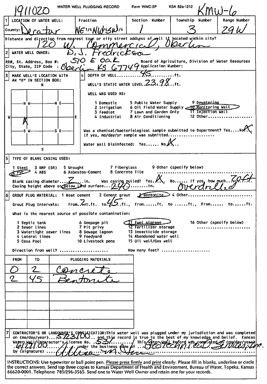
T3S, R29W, Sec. 1 NE NW SW |
Fredrickson, D.J. | 45 ft. | 23.98 ft. | Monitoring well/observation/piezometer | KMW-6 | Plugged | 23-May-2000 | Scan | |
|
T3S, R29W, Sec. 1 NE NW SW |
Fredrickson, D.J. | 45 ft. | 30.19 ft. | Monitoring well/observation/piezometer | MW 6 | Constructed | 12-Feb-1992 | ||
|
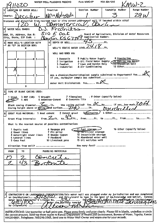
T3S, R29W, Sec. 1 NE NW SW |
Fredrickson, D.J. | 43 ft. | 24.18 ft. | Monitoring well/observation/piezometer | KMW-2 | Plugged | 23-May-2000 | Scan | |
|
T3S, R29W, Sec. 1 SW SE NW |
Fredrickson, D.J. | 31.5 ft. | 24.2 ft. | Monitoring well/observation/piezometer | KMW 11 | Constructed | 10-Jun-2004 | ||
|
T3S, R29W, Sec. 1 SW SE NW |
Fredrickson, D.J. | 30 ft. | 23.9 ft. | Monitoring well/observation/piezometer | KMW 10 | Constructed | 10-Jun-2004 | ||
|
T3S, R29W, Sec. 1 NE NW SW |
Fredrickson, D.J. | 43 ft. | 30.1 ft. | Monitoring well/observation/piezometer | MW 2 | Constructed | 28-Feb-1992 | ||
|
T3S, R29W, Sec. 1 NE NW SW |
Fredrickson, D.J. | 43 ft. | 29.5 ft. | Monitoring well/observation/piezometer | MW 1 | Constructed | 10-Feb-1992 | ||
|
T3S, R29W, Sec. 1 NE NW SW |
Fredrickson, D.J. | 43 ft. | 29.82 ft. | Monitoring well/observation/piezometer | MW 5 | Constructed | 12-Feb-1992 | ||
|
T3S, R29W, Sec. 1 NE NW SW |
Fredrickson, D.J. | 43 ft. | 29.1 ft. | Monitoring well/observation/piezometer | MW 8 | Constructed | 13-Feb-1992 | ||
|
T3S, R29W, Sec. 1 NE NW SW |
Fredrickson, D.J. | 43 ft. | 29.03 ft. | Monitoring well/observation/piezometer | MW 9 | Constructed | 28-Feb-1992 | ||
|
T3S, R29W, Sec. 1 NE NW SW |
Fredrickson, D.J. | 43 ft. | 29.49 ft. | Monitoring well/observation/piezometer | MW 7 | Constructed | 13-Feb-1992 | ||
|
T3S, R29W, Sec. 1 NE NE NW NE |
Fredrickson, Gary | 60 ft. | 53.95 ft. | Monitoring well/observation/piezometer | MW 8 | Constructed | 24-Apr-2019 | ||
|
T3S, R29W, Sec. 1 SW NE NW |
Fringer, Clara | 42 ft. | 30 ft. | Irrigation | Plugged | 18-Mar-1994 | |||
|
T3S, R29W, Sec. 1 NW NW NE SW |
Gilliam, Lee | 36 ft. | 20.15 ft. | Monitoring well/observation/piezometer | KMW 13 | Constructed | 06-Dec-2019 | ||
|
T3S, R29W, Sec. 1 NW NE SE NW |
Gish, Tim | 68 ft. | 43 ft. | 15 gpm. | Domestic, Lawn and Garden | Constructed | 10-Aug-2021 |
KOLAR |
|
| View page: < Prev || 11 || 12 || 13 || 14 || 15 || 16 || 17 || 18 || 19 || 20 || Next > | |||||||||