Select location of well to view details.
Click on column heading to sort.
|
|
|
County: Decatur Select location of well to view details. Click on column heading to sort. |
|
|
|
| View page: 1 || 2 || 3 || 4 || 5 || 6 || 7 || 8 || 9 || 10 || Next > | |||||||||
| T-R-S | Owner | Well Depth Ascend. Desc. |
Static Water Level Ascend. Desc. |
Est. Yield Ascend. Desc. |
Well Use | Other ID | Action Taken | Completion Date Ascend. Desc. |
Scan? |
|
T2S, R29W, Sec. 3 NE SE NE NE |
Schlegal, Tanner | 220 ft. | 170 ft. | 12 gpm. | Domestic, Livestock | Constructed | 26-May-2021 |
KOLAR |
|
|
T2S, R29W, Sec. 3 SW SW SW |
Urban, Willa | 210 ft. | 175 ft. | 5 gpm. | Domestic | Constructed | 23-Mar-2011 | ||
|
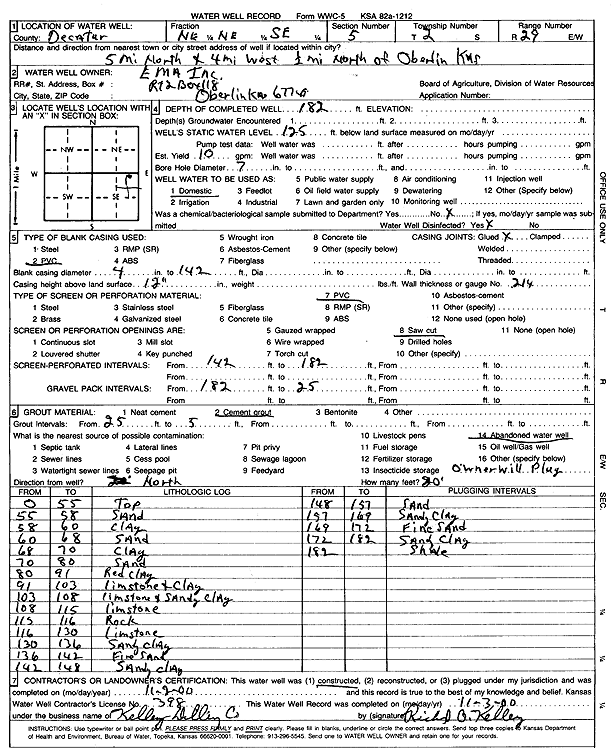
T2S, R29W, Sec. 5 NE NE SE |
EMA Inc. | 182 ft. | 125 ft. | 10 gpm. | Domestic | Constructed | 02-Nov-2000 | Scan | |
|
T2S, R29W, Sec. 6 SE SW SW |
Grafel Farms | 220 ft. | 115 ft. | 15 gpm. | Domestic | Constructed | 19-Nov-2013 | ||
|
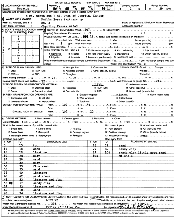
T2S, R29W, Sec. 10 SE SE SE |
Kathka Farms Partnership | 107 ft. | 71 ft. | 2 gpm. | Domestic | Constructed | 29-Jun-1992 | Scan | |
|
T2S, R29W, Sec. 10 NE NE NE |
Scott, Roland | 180 ft. | 157 ft. | 3 gpm. | Domestic | Constructed | 05-Jun-1998 | Scan | |
|
T2S, R29W, Sec. 11 SE SW SE SE |
Decatur Beef | 145 ft. | 105 ft. | 20 gpm. | Domestic | Constructed | 01-Jul-2019 |
KOLAR |
|
|
T2S, R29W, Sec. 12 SW SE NW SE |
Euhus, Dennis | 93 ft. | 60 ft. | 20 gpm. | Domestic, Livestock | Constructed | 08-Nov-2013 |
KOLAR |
|
|
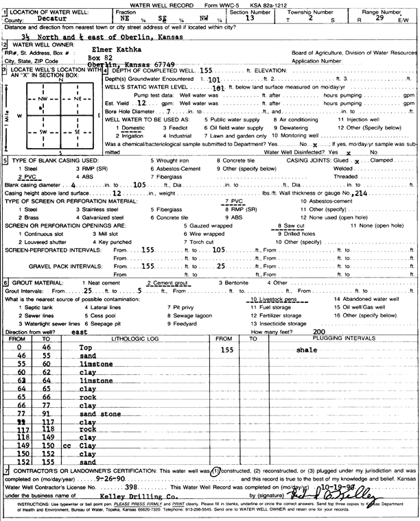
T2S, R29W, Sec. 13 NE SE NW |
Kathka, Elmer | 155 ft. | 101 ft. | 12 gpm. | Domestic | Constructed | 26-Sep-1990 | Scan | |
|
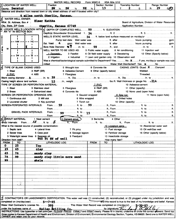
T2S, R29W, Sec. 13 SW SW NE |
Kathka, Elmer | 99 ft. | 34 ft. | 4 gpm. | Domestic | Constructed | 07-May-1985 | Scan | |
|
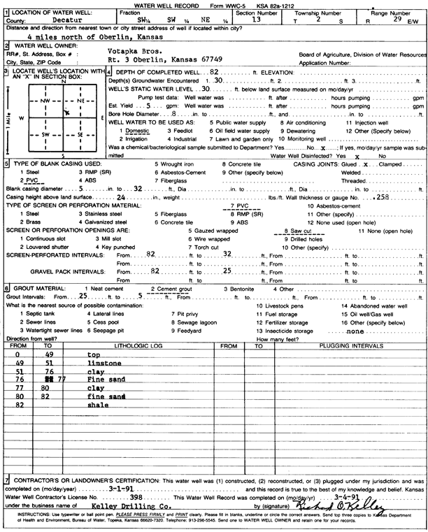
T2S, R29W, Sec. 13 SW SW NE |
Votapka Bros. | 82 ft. | 30 ft. | 5 gpm. | Domestic | Constructed | 01-Mar-1991 | Scan | |
|
T2S, R29W, Sec. 16 NW NW NW |
Scott, Freda | 73 ft. | 30 ft. | 4 gpm. | Domestic | Constructed | 06-May-2009 | ||
|
T2S, R29W, Sec. 18 SW NE NE SW |
May, Martin E and Evelyn (was Murfin) | 210 ft. | 90 ft. | Domestic, changed from Oil Field Water Supply | Constructed | 29-Dec-2010 | |||
|
T2S, R29W, Sec. 18 E2 NW NW SE |
Torleumke, Jeff | 200 ft. | Oil Field Water Supply | Constructed | 04-Jun-2011 | ||||
|
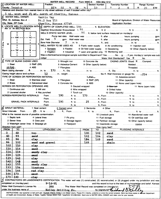
T2S, R29W, Sec. 19 SE SW NW |
May, Martin | 190 ft. | 96 ft. | 5 gpm. | Domestic | Constructed | 16-Sep-1991 | Scan | |
|
T2S, R29W, Sec. 20 NE SE SE |
Shaw, Anna | 120 ft. | 60 ft. | 25 gpm. | Domestic, Livestock | Constructed | 05-Mar-2024 |
KOLAR |
|
|
T2S, R29W, Sec. 22 SE NW SE NW |
Britton, Scott | 83 ft. | 38 ft. | 15 gpm. | Domestic | Constructed | 28-Aug-2017 |
KOLAR |
|
|
T2S, R29W, Sec. 23 SE SE SE |
Bronne, Doug | 50 ft. | 28 ft. | 10 gpm. | Domestic | Constructed | 24-Nov-2008 | ||
|
T2S, R29W, Sec. 23 SE NE NE SE |
Brown, Doug | 145 ft. | 77 ft. | 15 gpm. | Domestic, Livestock | Constructed | 02-Apr-2021 |
KOLAR |
|
|
T2S, R29W, Sec. 23 NE SE SW |
Shields, Mike | 120 ft. | 65 ft. | Domestic, Livestock | Constructed | 01-Oct-2023 |
KOLAR |
||
|
T2S, R29W, Sec. 24 NW NE NW |
Decatur County Beef | 170 ft. | 102 ft. | 90 gpm. | Other
(test well for irrigation drilling) |
Constructed | 17-Nov-2023 |
KOLAR |
|
|
T2S, R29W, Sec. 24 NW NE NW |
Decatur County Beef | 170 ft. | 100 ft. | Test hole/well | Plugged | 13-Nov-2025 |
KOLAR |
||
|
T2S, R29W, Sec. 24 SW SW NW SW |
Nutrien Ag | 128 ft. | 110 ft. | Domestic | Plugged | 28-Jul-2019 |
KOLAR |
||
|
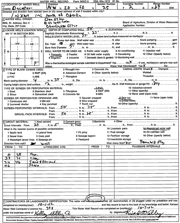
T2S, R29W, Sec. 25 NW SE SE |
Eiler, Dan | 50 ft. | 27 ft. | 10 gpm. | Domestic | Constructed | 01-Oct-2002 | Scan | |
|
T2S, R29W, Sec. 25 SW SW SW |
Lavers, Roger | 106 ft. | 80 ft. | 10 gpm. | Domestic | Constructed | 21-May-2013 | ||
|
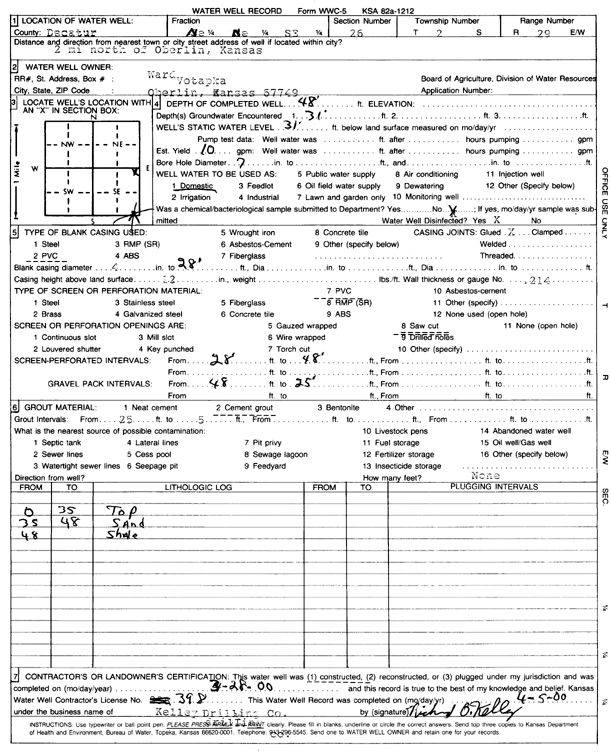
T2S, R29W, Sec. 26 NE NE SE |
Votapka, Ward | 48 ft. | 31 ft. | 10 gpm. | Domestic | Constructed | 28-Mar-2000 | Scan | |
|
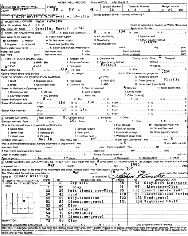
T2S, R29W, Sec. 26 SW SW NE |
Votopka, Dale | 134 ft. | Domestic | Constructed | 09-May-1980 | Scan | |||
|
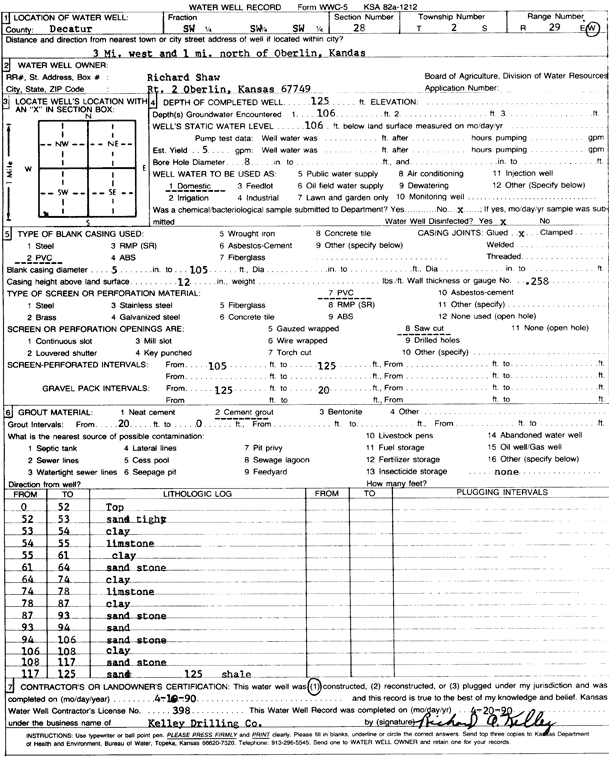
T2S, R29W, Sec. 28 SW SW SW |
Shaw, Richard | 125 ft. | 106 ft. | 5 gpm. | Domestic | Constructed | 16-Apr-1990 | Scan | |
|
T2S, R29W, Sec. 29 NE SW NE |
Shaw, Joel | 168 ft. | 118 ft. | 10 gpm. | Domestic | Constructed | 09-Oct-2008 | ||
|
T2S, R29W, Sec. 29 SW NE NE |
Shaw, Ralph | 170 ft. | 95 ft. | Domestic | Constructed | 19-Jul-1985 | Scan | ||
|
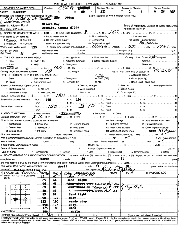
T2S, R29W, Sec. 30 C SE |
May, Elbert | 180 ft. | 123 ft. | 8 gpm. | Domestic, Livestock | Constructed | 24-Mar-1981 | Scan | |
|
T2S, R29W, Sec. 31 NE NE |
Scott, Justin and Wendy | 180 ft. | 22 ft. | Domestic | Constructed | 26-Feb-2006 | |||
|
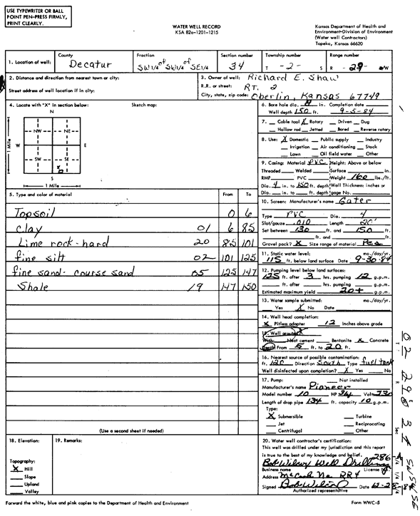
T2S, R29W, Sec. 34 SW SW SE |
Shaw, Richard | 150 ft. | 115 ft. | 20 gpm. | Domestic | Constructed | 05-Sep-1984 | Scan | |
|
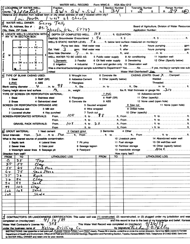
T2S, R29W, Sec. 34 SW SW SW |
Tally, Gerry | 108 ft. | 96 ft. | 3 gpm. | Domestic | Constructed | 14-Apr-1989 | Scan | |
|
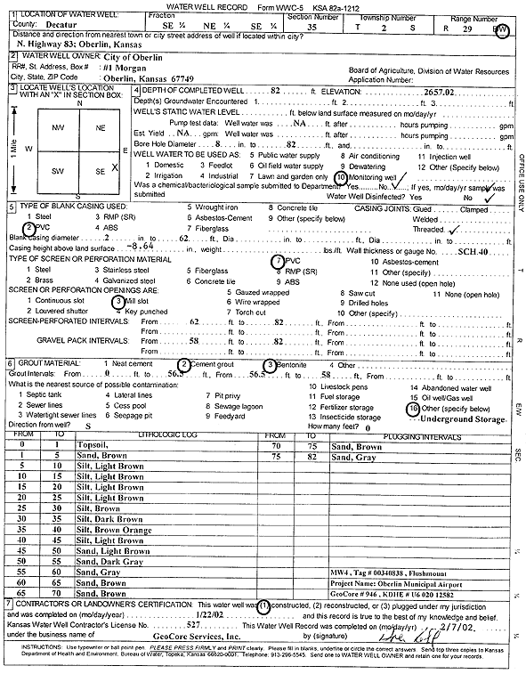
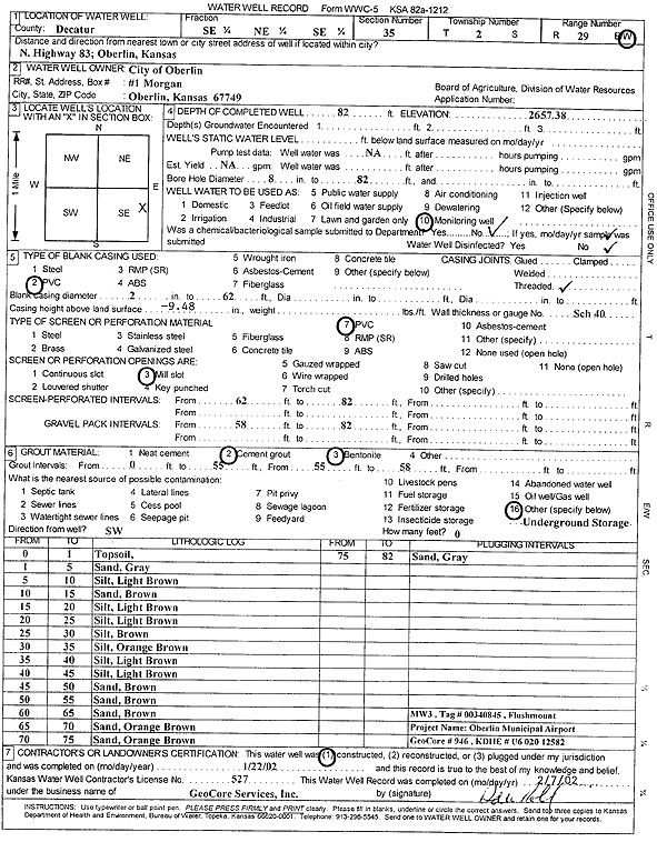
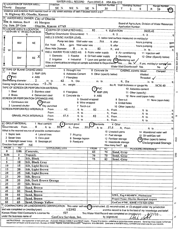
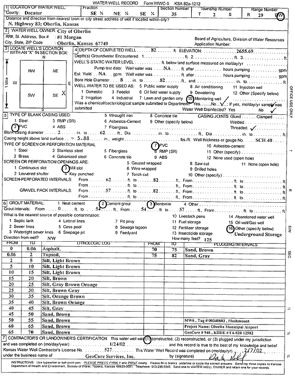
T2S, R29W, Sec. 35 SE NE SE |
City of Oberlin | 82 ft. | Monitoring well/observation/piezometer | MW 4 | Constructed | 22-Jan-2002 | Scan | ||
|
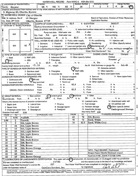
T2S, R29W, Sec. 35 SE NE SE |
City of Oberlin | 82.5 ft. | Monitoring well/observation/piezometer | MW 1 | Constructed | 17-Jan-2002 | Scan | ||
|
T2S, R29W, Sec. 35 SE NE SE |
City of Oberlin | 82 ft. | 69.16 ft. | Monitoring well/observation/piezometer | MW 5 | Plugged | 11-Jan-2005 | ||
|
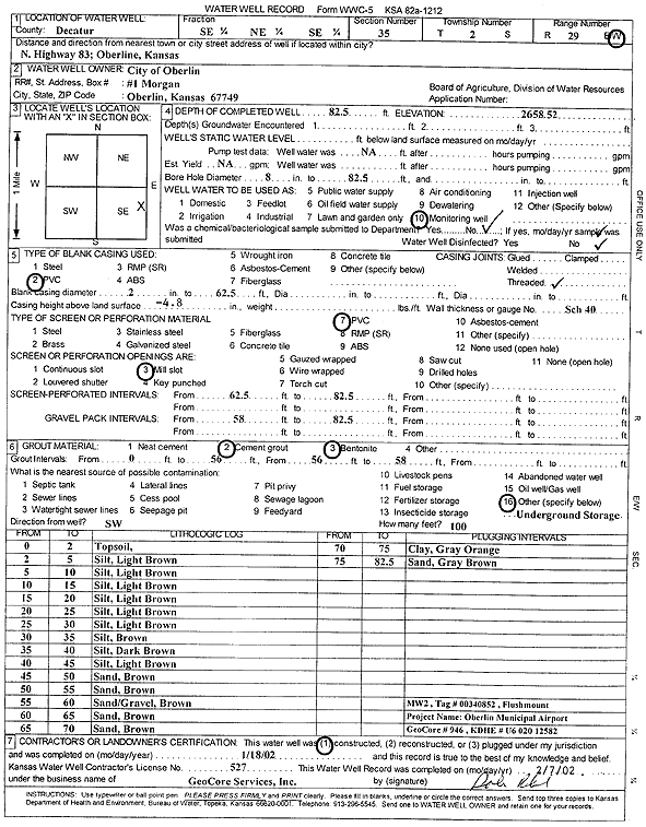
T2S, R29W, Sec. 35 SE NE SE |
City of Oberlin | 82.5 ft. | 71.83 ft. | Monitoring well/observation/piezometer | MW 2 | Plugged | 11-Jan-2005 | ||
|
T2S, R29W, Sec. 35 SE NE SE |
City of Oberlin | 82 ft. | 73.02 ft. | Monitoring well/observation/piezometer | MW 6 | Plugged | 11-Jan-2005 | ||
|
T2S, R29W, Sec. 35 SE NE SE |
City of Oberlin | 82.5 ft. | 72.02 ft. | Monitoring well/observation/piezometer | MW 1 | Plugged | 11-Jan-2005 | ||
|
T2S, R29W, Sec. 35 SE NE SE |
City of Oberlin | 82 ft. | 70.94 ft. | Monitoring well/observation/piezometer | MW 3 | Plugged | 11-Jan-2005 | ||
|
T2S, R29W, Sec. 35 SE NE SE |
City of Oberlin | 82.5 ft. | Monitoring well/observation/piezometer | MW 2 | Constructed | 18-Jan-2002 | Scan | ||
|
T2S, R29W, Sec. 35 SE NE SE |
City of Oberlin | 82 ft. | Monitoring well/observation/piezometer | MW 3 | Constructed | 22-Jan-2002 | Scan | ||
|
T2S, R29W, Sec. 35 SE NE SE |
City of Oberlin | 82 ft. | Monitoring well/observation/piezometer | MW 5 | Constructed | 23-Jan-2002 | Scan | ||
|
T2S, R29W, Sec. 35 SE NE SE |
City of Oberlin | 82 ft. | Monitoring well/observation/piezometer | MW 6 | Constructed | 24-Jan-2002 | Scan | ||
|
T2S, R29W, Sec. 35 SE NE SE |
City of Oberlin | 82 ft. | 70.67 ft. | Monitoring well/observation/piezometer | MW 4 | Plugged | 11-Jan-2005 | ||
|
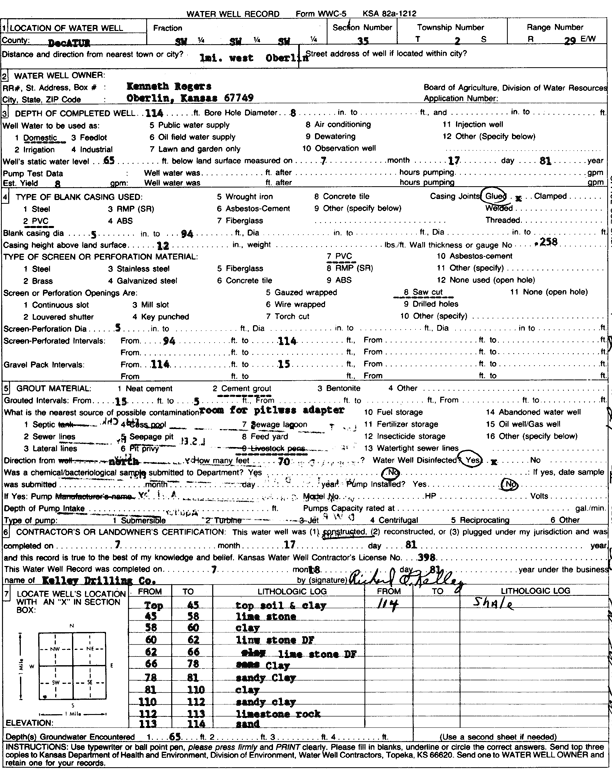
T2S, R29W, Sec. 35 SW SW SW |
Rogers, Kenneth | 114 ft. | 65 ft. | 8 gpm. | Domestic | Constructed | 17-Jul-1981 | Scan | |
|
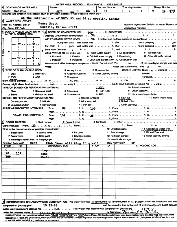
T2S, R29W, Sec. 35 SE SE SE |
Scott, Henry | 109 ft. | 94 ft. | 7 gpm. | Domestic | Constructed | 13-Oct-1988 | Scan | |
|
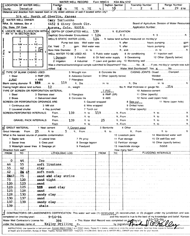
T2S, R29W, Sec. 35 SE NE NE |
Torluemke, Gary | 139 ft. | 124 ft. | 7 gpm. | Domestic | Constructed | 16-Sep-1994 | Scan | |
|
T2S, R29W, Sec. 36 SW SE SW |
Bricker, Jim | 90 ft. | Domestic | Constructed | 02-Oct-2001 | Scan | |||
| View page: 1 || 2 || 3 || 4 || 5 || 6 || 7 || 8 || 9 || 10 || Next > | |||||||||