Select location of well to view details.
Click on column heading to sort.
|
|
|
County: Douglas Select location of well to view details. Click on column heading to sort. |
|
|
|
| View page: < Prev || 21 || 22 || 23 || 24 || 25 || 26 || 27 || 28 || 29 || 30 || Next > | |||||||||
| T-R-S | Owner | Well Depth Ascend. Desc. |
Static Water Level Ascend. Desc. |
Est. Yield Ascend. Desc. |
Well Use | Other ID | Action Taken | Completion Date Ascend. Desc. |
Scan? |
|
T12S, R20E, Sec. 31 SW NW NW |
KDHE-BER | 20 ft. | Monitoring well/observation/piezometer | SVE 6 | Constructed | 23-May-2006 | |||
|
T12S, R20E, Sec. 31 SW NW NW |
KDHE-BER | 20 ft. | 10.31 ft. | Monitoring well/observation/piezometer | MW 12 | Constructed | 10-May-2006 | ||
|
T12S, R20E, Sec. 31 SW NW NW |
KDHE-BER | 20 ft. | 7.2 ft. | Monitoring well/observation/piezometer | MW 14 | Constructed | 12-May-2006 | ||
|
T12S, R20E, Sec. 31 SW NW NW |
KDHE-BER | 20 ft. | Monitoring well/observation/piezometer | SVE 4 | Constructed | 23-May-2006 | |||
|
T12S, R20E, Sec. 31 SW NW NW |
KDHE-BER | 20 ft. | Monitoring well/observation/piezometer | SVE 5 | Constructed | 23-May-2006 | |||
|
T12S, R20E, Sec. 31 SW NW NW |
KDHE-BER | 20 ft. | 9.5 ft. | Monitoring well/observation/piezometer | MW 15 | Constructed | 12-May-2006 | ||
|
T12S, R20E, Sec. 31 W2 SW NW NW |
KDHE-BER | 20 ft. | 18.85 ft. | Monitoring well/observation/piezometer | MW 23 | Constructed | 15-May-2006 | ||
|
T12S, R20E, Sec. 31 SW NW NW |
KDHE-BER | 20 ft. | 9.23 ft. | Monitoring well/observation/piezometer | MW 18 | Constructed | 12-May-2006 | ||
|
T12S, R20E, Sec. 31 W2 SW NW NW |
KDHE-BER | 20 ft. | 12.1 ft. | Monitoring well/observation/piezometer | MW 16 | Constructed | 12-May-2006 | ||
|
T12S, R20E, Sec. 31 SW NW NW |
KDHE-BER | 20 ft. | Monitoring well/observation/piezometer | SVE 1 | Constructed | 23-May-2006 | |||
|
T12S, R20E, Sec. 31 SW NW NW |
KDHE-BER | 20 ft. | Monitoring well/observation/piezometer | SVE 7 | Constructed | 23-May-2006 | |||
|
T12S, R20E, Sec. 31 SW NW NW |
KDHE-BER | 20 ft. | 10.96 ft. | Monitoring well/observation/piezometer | MW 10 | Constructed | 08-May-2006 | ||
|
T12S, R20E, Sec. 31 W2 SW NW NW |
KDHE-BER | 20 ft. | 12.3 ft. | Monitoring well/observation/piezometer | MW 13 | Constructed | 10-May-2006 | ||
|
T12S, R20E, Sec. 31 SW NW NW |
KDHE-BER | 20 ft. | Monitoring well/observation/piezometer | SVE 2 | Constructed | 23-May-2006 | |||
|
T12S, R20E, Sec. 31 SW NW NW |
KDHE-BER | 20 ft. | 11 ft. | Monitoring well/observation/piezometer | MW 6 | Constructed | 09-May-2006 | ||
|
T12S, R20E, Sec. 31 SW NW NW |
KDHE-BER | 20 ft. | 10.1 ft. | Monitoring well/observation/piezometer | MW 5 | Constructed | 09-May-2006 | ||
|
T12S, R20E, Sec. 31 SW NW NW |
KDHE-BER | 20 ft. | 12.49 ft. | Monitoring well/observation/piezometer | MW 22 | Constructed | 15-May-2006 | ||
|
T12S, R20E, Sec. 31 SW NW NW |
KDHE-BER | 20 ft. | 11.4 ft. | Monitoring well/observation/piezometer | MW 11 | Constructed | 10-May-2006 | ||
|
T12S, R20E, Sec. 31 NE SW NE |
Patchen Electric and Ind. Supply, Inc. | 96 ft. | 20 gpm. | Domestic | Constructed | 08-Sep-1992 | Scan | ||
|
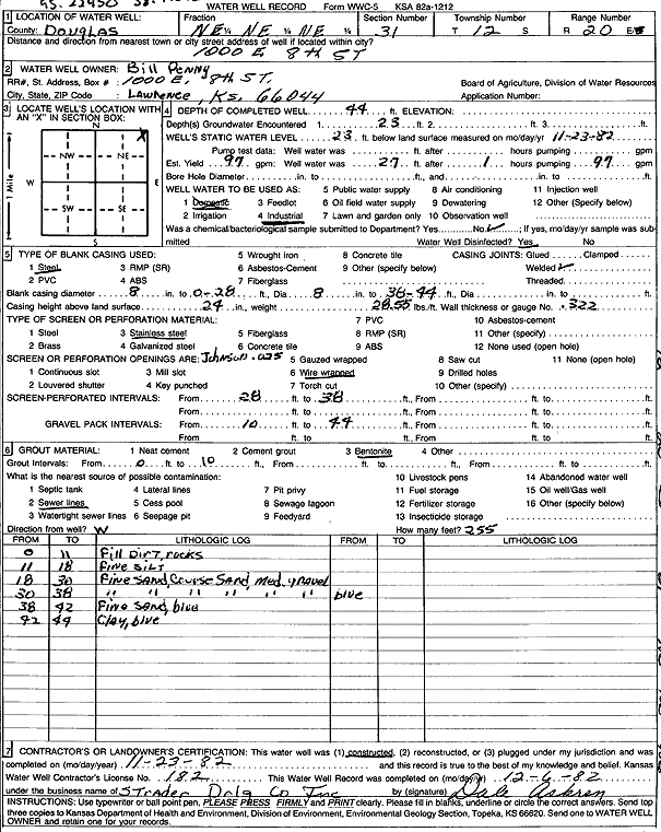
T12S, R20E, Sec. 31 NE NE NE |
Penny, Bill | 44 ft. | 23 ft. | 97 gpm. | Industrial | Constructed | 23-Nov-1982 | Scan | |
|
T12S, R20E, Sec. 31 NE NE NE |
Pennys Concrete | 45 ft. | 25 ft. | 124 gpm. | Industrial | Constructed | 22-Feb-2010 | ||
|
T12S, R20E, Sec. 31 NE NE NE |
Pennys Concrete | 44 ft. | 97 gpm. | Industrial | Plugged | 22-Jan-2010 | |||
|
T12S, R20E, Sec. 31 NW SE NE |
Phillips 66 Co. | 19.5 ft. | 14.28 ft. | Monitoring well/observation/piezometer | MW 1 | Constructed | 06-Feb-2025 |
KOLAR |
|
|
T12S, R20E, Sec. 31 NW SE NE |
Phillips 66 Co. | 17 ft. | 12.12 ft. | Monitoring well/observation/piezometer | MW 3 | Constructed | 06-Feb-2025 |
KOLAR |
|
|
T12S, R20E, Sec. 31 NW SE NE |
Phillips 66 Co. | 19.5 ft. | 14.36 ft. | Monitoring well/observation/piezometer | MW 2 | Constructed | 06-Feb-2025 |
KOLAR |
|
|
T12S, R20E, Sec. 31 NW NW SW NW |
Presta Oil Inc. | 20 ft. | 9.96 ft. | Monitoring well/observation/piezometer | MW 29 | Constructed | 30-Apr-2018 |
KOLAR |
|
|
T12S, R20E, Sec. 31 SE SW NW NW |
Presta Oil Inc. | 20 ft. | 10.02 ft. | Monitoring well/observation/piezometer | MW 28 | Constructed | 30-Apr-2018 |
KOLAR |
|
|
T12S, R20E, Sec. 31 SE SW NW NW |
Presta Oil Inc. | 20 ft. | 9.29 ft. | Monitoring well/observation/piezometer | MW 27 | Constructed | 30-Apr-2018 |
KOLAR |
|
|
T12S, R20E, Sec. 31 SE SW NW NW |
Presta Oil Inc. | 20 ft. | 9.56 ft. | Monitoring well/observation/piezometer | MW 26 | Constructed | 30-Apr-2018 |
KOLAR |
|
|
T12S, R20E, Sec. 31 NW NE SE NW |
Schmalberg, Jeff | Monitoring well/observation/piezometer | MW 3 | Plugged | 19-May-2014 | ||||
|
T12S, R20E, Sec. 31 NW NE SE NW |
Schmalberg, Jeff | Monitoring well/observation/piezometer | MW 4 | Plugged | 19-May-2014 | ||||
|
T12S, R20E, Sec. 31 N2 SE NW |
Schmalberg, Jeff | 15.5 ft. | 13.78 ft. | Monitoring well/observation/piezometer | MW 2 | Constructed | 21-Oct-2002 | ||
|
T12S, R20E, Sec. 31 N2 SE NW |
Schmalberg, Jeff | 14.5 ft. | 13.87 ft. | Monitoring well/observation/piezometer | MW 6 | Constructed | 22-Oct-2002 | ||
|
T12S, R20E, Sec. 31 NW NE SE NW |
Schmalberg, Jeff | Monitoring well/observation/piezometer | MW 1 | Plugged | 19-May-2014 | ||||
|
T12S, R20E, Sec. 31 NW NE SE NW |
Schmalberg, Jeff | Monitoring well/observation/piezometer | MW 5 | Plugged | 19-May-2014 | ||||
|
T12S, R20E, Sec. 31 NW NE SE NW |
Schmalberg, Jeff | Monitoring well/observation/piezometer | MW 6 | Plugged | 19-May-2014 | ||||
|
T12S, R20E, Sec. 31 NW NE SE NW |
Schmalberg, Jeff | Monitoring well/observation/piezometer | MW 7 | Plugged | 19-May-2014 | ||||
|
T12S, R20E, Sec. 31 NW NE SE NW |
Schmalberg, Jeff | Monitoring well/observation/piezometer | MW 2 | Plugged | 19-May-2014 | ||||
|
T12S, R20E, Sec. 31 N2 SE NW |
Schmalberg, Jeff | 16 ft. | Monitoring well/observation/piezometer | MW 7 | Constructed | 22-Oct-2002 | |||
|
T12S, R20E, Sec. 31 N2 SE NW |
Schmalberg, Jeff | 18 ft. | 6.43 ft. | Monitoring well/observation/piezometer | MW 5 | Constructed | 22-Oct-2002 | ||
|
T12S, R20E, Sec. 31 N2 SE NW |
Schmalberg, Jeff | 15.5 ft. | 14.8 ft. | Monitoring well/observation/piezometer | MW 4 | Constructed | 22-Oct-2002 | ||
|
T12S, R20E, Sec. 31 N2 SE NW |
Schmalberg, Jeff | 16 ft. | 11.38 ft. | Monitoring well/observation/piezometer | MW 3 | Constructed | 22-Oct-2002 | ||
|
T12S, R20E, Sec. 31 N2 SE NW |
Schmalberg, Jeff | 18 ft. | 11.19 ft. | Monitoring well/observation/piezometer | MW 1 | Constructed | 21-Oct-2002 | ||
|
T12S, R20E, Sec. 31 SW NW NW |
Schriner, Daniel L | 20 ft. | 14.5 ft. | Monitoring well/observation/piezometer | MW 2 | Constructed | 08-May-2014 | ||
|
T12S, R20E, Sec. 31 SW NW NW |
Schriner, Daniel L | 25 ft. | 15.5 ft. | Monitoring well/observation/piezometer | MW 1 | Constructed | 05-May-2014 | ||
|
T12S, R20E, Sec. 31 NW NE NW NE |
Scott Temperature Equipment | 250 ft. | Geothermal, Closed Loop, Vertical | Constructed | 19-Sep-2018 |
KOLAR |
|||
|
T12S, R20E, Sec. 31 W2 SW SW |
University of Kansas | 400 ft. | 20 gpm. | Air Conditioning | Constructed | 30-Aug-2004 | |||
|
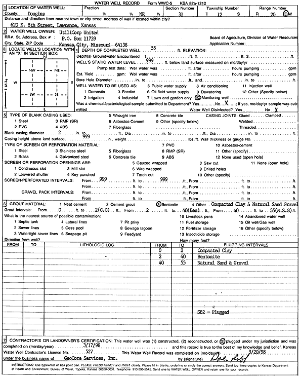
T12S, R20E, Sec. 31 NE |
UtiliCorp United | 55 ft. | Monitoring well/observation/piezometer | SB 2 | Plugged | 17-Mar-1998 | Scan | ||
|
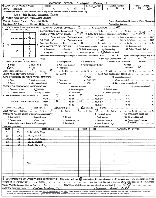
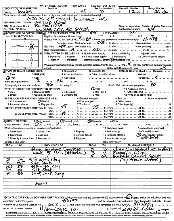
T12S, R20E, Sec. 31 NE |
UtiliCorp United | 55 ft. | 32.84 ft. | Monitoring well/observation/piezometer | MW 1 | Constructed | 17-Mar-1998 | Scan | |
|
T12S, R20E, Sec. 31 NE |
UtiliCorp United | 55 ft. | 32.84 ft. | Monitoring well/observation/piezometer | MW 1 | Plugged | 06-Apr-2000 | Scan | |
| View page: < Prev || 21 || 22 || 23 || 24 || 25 || 26 || 27 || 28 || 29 || 30 || Next > | |||||||||