Select location of well to view details.
Click on column heading to sort.
|
|
|
County: Douglas Select location of well to view details. Click on column heading to sort. |
|
|
|
| View page: < Prev || 31 || 32 || 33 || 34 || 35 || 36 || 37 || 38 || 39 || 40 || Next > | |||||||||
| T-R-S | Owner | Well Depth Ascend. Desc. |
Static Water Level Ascend. Desc. |
Est. Yield Ascend. Desc. |
Well Use | Other ID | Action Taken | Completion Date Ascend. Desc. |
Scan? |
|
T13S, R20E, Sec. 6 SW SE NW |
McBride, Walter | 20 ft. | 25 ft. | Monitoring well/observation/piezometer | MW 6 R | Constructed | 14-Nov-2006 | ||
|
T13S, R20E, Sec. 6 SW SE NW |
McBride, Walter | 20 ft. | 9.9 ft. | Monitoring well/observation/piezometer | MW 7 R | Constructed | 14-Nov-2006 | ||
|
T13S, R20E, Sec. 6 SW NE SE |
Ottawa Coop | 12 ft. | 4.32 ft. | Monitoring well/observation/piezometer | MW 3RR | Constructed | 31-Mar-2026 |
KOLAR |
|
|
T13S, R20E, Sec. 6 SW NE SE |
Ottawa Coop | 13 ft. | 4.32 ft. | Monitoring well/observation/piezometer | MW 3R | Constructed | 31-Jan-2024 |
KOLAR |
|
|
T13S, R20E, Sec. 6 SW NE SE |
Ottawa Coop | 13 ft. | 4.32 ft. | Monitoring well/observation/piezometer | MW 3 | Plugged | 31-Jan-2024 |
KOLAR |
|
|
T13S, R20E, Sec. 6 SW NE SE |
Ottawa Coop | 13 ft. | 4.32 ft. | Monitoring well/observation/piezometer | MW 3R | Plugged | 31-Jan-2024 |
KOLAR |
|
|
T13S, R20E, Sec. 6 NE SW SE NE |
Scott Temperature Equipment | 200 ft. | 48 ft. | 10 gpm. | Geothermal, Closed Loop, Vertical | Constructed | 19-Dec-2012 | ||
|
T13S, R20E, Sec. 6 NW SW SE |
Smith, Deborah/Hagen, Robert | 400 ft. | 20 ft. | 30 gpm. | Geothermal, Closed Loop, Vertical | Constructed | 01-Dec-2022 |
KOLAR |
|
|
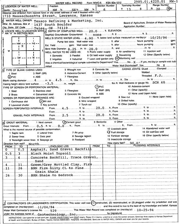
T13S, R20E, Sec. 6 NW SE NW |
Texaco Refining and Marketing | 20 ft. | 4.9 ft. | Monitoring well/observation/piezometer | MW 1 | Constructed | 04-Nov-1994 | Scan | |
|
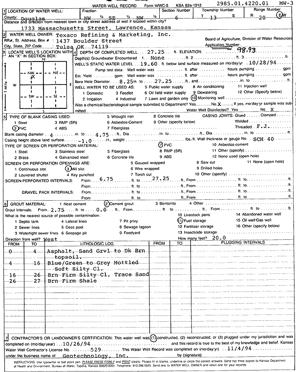
T13S, R20E, Sec. 6 NW SE NW |
Texaco Refining and Marketing | 27.25 ft. | 19.6 ft. | Monitoring well/observation/piezometer | MW 3 | Constructed | 26-Oct-1994 | Scan | |
|
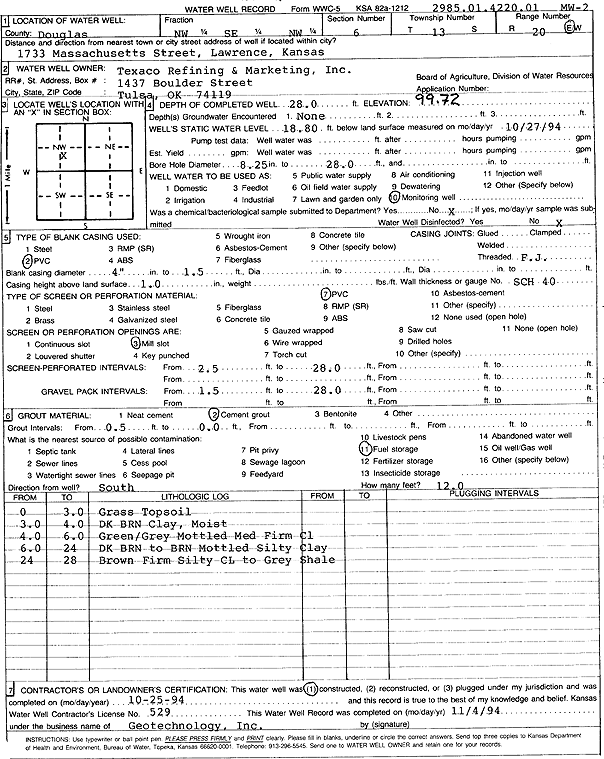
T13S, R20E, Sec. 6 NW SE NW |
Texaco Refining and Marketing, Inc. | 28 ft. | 18.8 ft. | Monitoring well/observation/piezometer | MW 2 | Constructed | 25-Oct-1994 | Scan | |
|
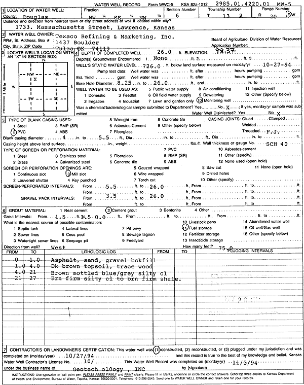
T13S, R20E, Sec. 6 NW SE NW |
Texaco Refining and Marketing, Inc. | 26 ft. | Monitoring well/observation/piezometer | MW 5 | Constructed | 27-Oct-1994 | Scan | ||
|
T13S, R20E, Sec. 6 SE SW SE |
USGS/KGS | 154 ft. | Test Hole, Uncased | Constructed | 01-Jul-1984 | ||||
|
T13S, R20E, Sec. 7 NW NW NW |
BP Products North America | 20 ft. | 2.95 ft. | Monitoring well/observation/piezometer | MW 8 | Plugged | 11-Jan-2010 | ||
|
T13S, R20E, Sec. 7 NW NW NW |
BP Products North America | 19.5 ft. | 7.91 ft. | Monitoring well/observation/piezometer | MW 15 | Plugged | 11-Jan-2010 | ||
|
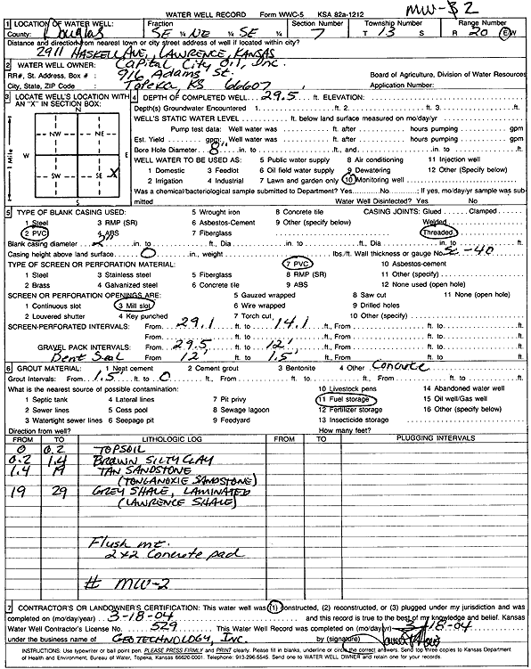
T13S, R20E, Sec. 7 SE NE SE |
Capital City Oil, Inc. | 29.5 ft. | Monitoring well/observation/piezometer | MW 2 | Constructed | 18-Mar-2004 | Scan | ||
|
T13S, R20E, Sec. 7 SE NE SE |
Capital City Oil, Inc. | 29.5 ft. | Monitoring well/observation/piezometer | MW 5 | Constructed | 18-Mar-2004 | Scan | ||
|
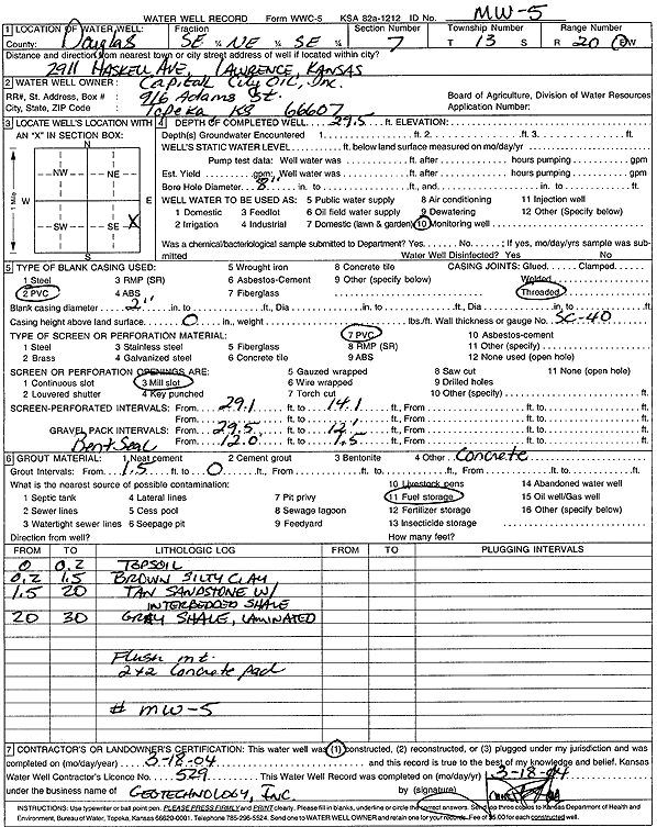
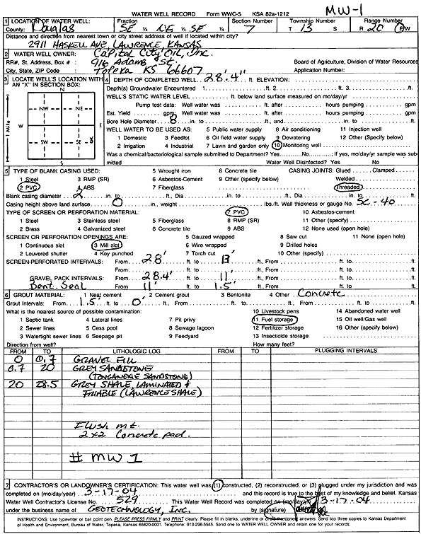
T13S, R20E, Sec. 7 SE NE SE |
Capital City Oil, Inc. | 28.33 ft. | Monitoring well/observation/piezometer | MW 3 | Constructed | 17-Mar-2004 | Scan | ||
|
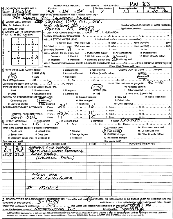
T13S, R20E, Sec. 7 SE NE SE |
Capital City Oil, Inc. | 29.5 ft. | Monitoring well/observation/piezometer | MW 4 | Constructed | 18-Mar-2004 | Scan | ||
|
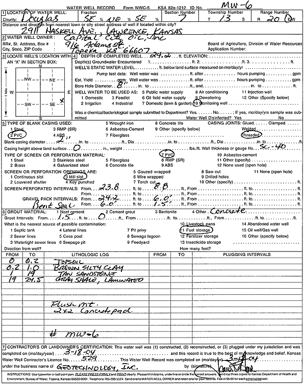
T13S, R20E, Sec. 7 SE NE SE |
Capital City Oil, Inc. | 24.2 ft. | Monitoring well/observation/piezometer | MW 6 | Constructed | 18-Mar-2004 | Scan | ||
|
T13S, R20E, Sec. 7 SE SE SE |
Capital City Oil, Inc. | 19 ft. | 4.72 ft. | Monitoring well/observation/piezometer | MW 7 | Constructed | 29-Sep-2005 | ||
|
T13S, R20E, Sec. 7 NE SE SE |
Capital City Oil, Inc. | 24 ft. | 8.56 ft. | Monitoring well/observation/piezometer | MW 8 | Plugged | 15-Jun-2006 | ||
|
T13S, R20E, Sec. 7 NE SE SE |
Capital City Oil, Inc. | 30 ft. | 14.22 ft. | Monitoring well/observation/piezometer | MW 4 | Plugged | 15-Jun-2006 | ||
|
T13S, R20E, Sec. 7 NE SE SE |
Capital City Oil, Inc. | 29 ft. | 11.5 ft. | Monitoring well/observation/piezometer | MW 2 | Plugged | 15-Jun-2006 | ||
|
T13S, R20E, Sec. 7 NE SE SE |
Capital City Oil, Inc. | 28.5 ft. | 11.25 ft. | Monitoring well/observation/piezometer | MW 3 | Plugged | 15-Jun-2006 | ||
|
T13S, R20E, Sec. 7 NE SE SE |
Capital City Oil, Inc. | 30 ft. | 9.97 ft. | Monitoring well/observation/piezometer | MW 5 | Plugged | 15-Jun-2006 | ||
|
T13S, R20E, Sec. 7 SE SE SE |
Capital City Oil, Inc. | 19 ft. | 5.93 ft. | Monitoring well/observation/piezometer | MW 7 | Plugged | 16-Jun-2006 | ||
|
T13S, R20E, Sec. 7 NE SE SE |
Capital City Oil, Inc. | 24 ft. | 10.81 ft. | Monitoring well/observation/piezometer | MW 6 | Plugged | 15-Jun-2006 | ||
|
T13S, R20E, Sec. 7 SE NE SE |
Capital City Oil, Inc. | 28.33 ft. | Monitoring well/observation/piezometer | MW 1 | Constructed | 17-Mar-2004 | Scan | ||
|
T13S, R20E, Sec. 7 SE SE SE |
Capital City Oil, Inc. | 24 ft. | 8.42 ft. | Monitoring well/observation/piezometer | MW 8 | Constructed | 29-Sep-2005 | ||
|
T13S, R20E, Sec. 7 NE SE SE |
Capital City Oil, Inc. | 28.5 ft. | 6.95 ft. | Monitoring well/observation/piezometer | MW 1 | Plugged | 15-Jun-2006 | ||
|
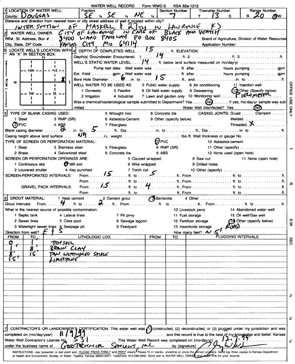
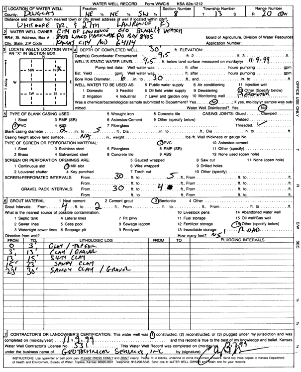
T13S, R20E, Sec. 7 SE SE NE |
City of Lawrence | 15 ft. | 14 ft. | Monitoring well/observation/piezometer | Constructed | 09-Nov-1999 | Scan | ||
|
T13S, R20E, Sec. 7 NW NE NE |
Douglas Co Public Works | 11 ft. | Monitoring well/observation/piezometer | MW 4 | Constructed | 18-Dec-2003 | Scan | ||
|
T13S, R20E, Sec. 7 NW NE NE |
Douglas Co Public Works | 13 ft. | Monitoring well/observation/piezometer | MW 3 | Constructed | 18-Dec-2003 | Scan | ||
|
T13S, R20E, Sec. 7 NE SW NW |
Jackson, James D. | 400 ft. | 5 ft. | 50 gpm. | Geothermal, Closed Loop, Vertical | Constructed | 08-May-2023 |
KOLAR |
|
|
T13S, R20E, Sec. 7 NW NW NW NW |
KDHE (Louisiana Purchase Shopping Center) | 14.5 ft. | 7.37 ft. | Monitoring well/observation/piezometer | MW 7 | Constructed | 16-Jul-2019 | ||
|
T13S, R20E, Sec. 7 NW NW NW NW |
KDHE (Louisiana Purchase Shopping Center) | 15 ft. | 7.15 ft. | Monitoring well/observation/piezometer | MW 9 | Constructed | 18-Jul-2019 | ||
|
T13S, R20E, Sec. 7 NW NW NE |
US Dept. of Interior Bureau of Indian Affairs | 260 ft. | Injection well/air sparge (AS)/shallow | Constructed | 26-May-1996 | ||||
|
T13S, R20E, Sec. 7 S2 SE SE NE |
Westar Energy Lawrence Center | 200 ft. | 50 ft. | 20 gpm. | Heat Pump (Closed Loop/Disposal), Geothermal | Plugged | 03-Sep-2008 | ||
|
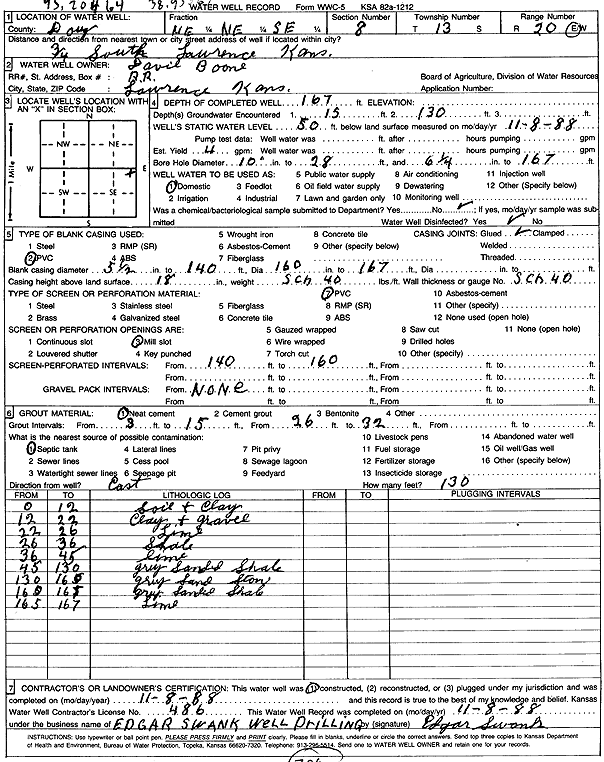
T13S, R20E, Sec. 8 NE NE SE |
Boone, David | 167 ft. | 50 ft. | 4 gpm. | Domestic | Constructed | 08-Nov-1988 | Scan | |
|
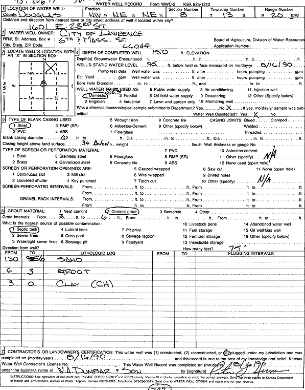
T13S, R20E, Sec. 8 NW NE NE |
City of Lawrence | 150 ft. | 95 ft. | Domestic | Plugged | 16-Aug-1990 | Scan | ||
|
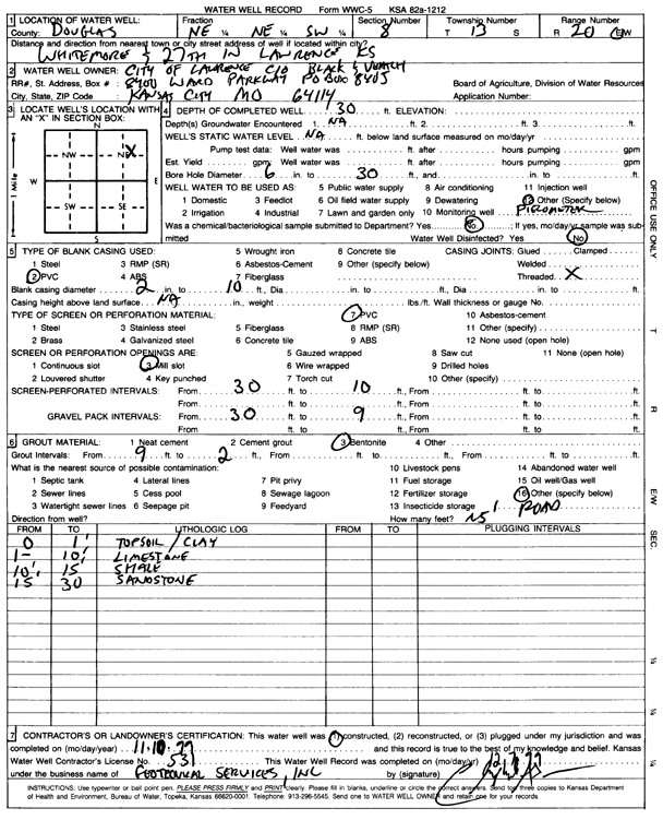
T13S, R20E, Sec. 8 NE NE SW |
City of Lawrence | 30 ft. | Monitoring well/observation/piezometer | Constructed | 10-Nov-1999 | Scan | |||
|
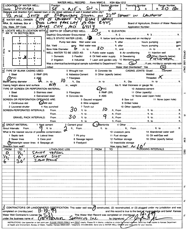
T13S, R20E, Sec. 8 SE NE SW |
City of Lawrence | 30 ft. | 10 ft. | Monitoring well/observation/piezometer | Constructed | 10-Nov-1999 | Scan | ||
|
T13S, R20E, Sec. 8 NW SW NE SW |
City of Lawrence | 400 ft. | Geothermal, Closed Loop, Vertical | Constructed | 22-Sep-2016 | ||||
|
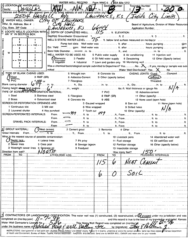
T13S, R20E, Sec. 8 NW NW NW |
City of Lawrence | 115 ft. | 75 ft. | Domestic | Plugged | 07-Nov-1996 | Scan | ||
|
T13S, R20E, Sec. 8 NE NE SW |
City of Lawrence | 30 ft. | 9.5 ft. | Monitoring well/observation/piezometer | Constructed | 09-Nov-1999 | Scan | ||
|
T13S, R20E, Sec. 8 SE SE SE |
Garber, Doug | 110 ft. | 70 ft. | Domestic | Reconstructed | 22-Aug-2007 | |||
|
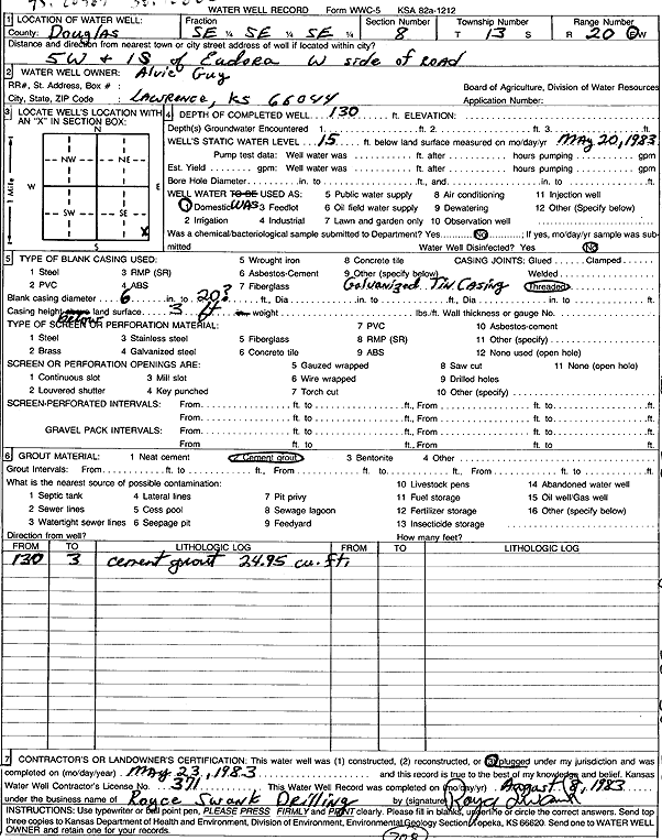
T13S, R20E, Sec. 8 SE SE SE |
Guy, Alvie | 130 ft. | 15 ft. | Domestic | Plugged | 23-May-1983 | Scan | ||
|
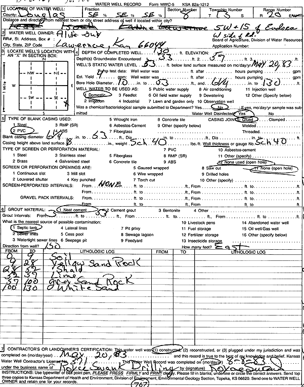
T13S, R20E, Sec. 8 SE SE SE |
Guy, Alvie | 130 ft. | 53 ft. | 4 gpm. | Domestic | Constructed | 20-May-1983 | Scan | |
|
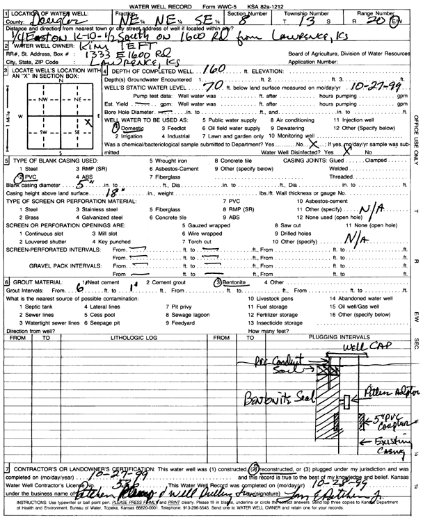
T13S, R20E, Sec. 8 NE NE SE |
Teft, Kim | 160 ft. | 70 ft. | Domestic | Reconstructed | 27-Oct-1999 | Scan | ||
| View page: < Prev || 31 || 32 || 33 || 34 || 35 || 36 || 37 || 38 || 39 || 40 || Next > | |||||||||