Select location of well to view details.
Click on column heading to sort.
|
|
|
County: Finney Select location of well to view details. Click on column heading to sort. |
|
|
|
| View page: < Prev || 101 || 102 || 103 || 104 || 105 || 106 || 107 || 108 || 109 || 110 | |||||||||
| T-R-S | Owner | Well Depth Ascend. Desc. |
Static Water Level Ascend. Desc. |
Est. Yield Ascend. Desc. |
Well Use | Other ID | Action Taken | Completion Date Ascend. Desc. |
Scan? |
|
T26S, R33W, Sec. 36 SE SE NW SE |
Standley, Barbara | 510 ft. | 288 ft. | 1354 gpm. | Irrigation | Constructed | 02-Apr-2014 |
KOLAR |
|
|
T26S, R33W, Sec. 36 SW SE NW SW |
Standley, Barbara | 508 ft. | 302 ft. | 1409 gpm. | Irrigation | Constructed | 28-Jan-2015 |
KOLAR |
|
|
T26S, R34W, Sec. 1 SE SW NE |
EOG Resources, Inc. | 360 ft. | 212 ft. | 100 gpm. | Oil Field Water Supply | J. O. Cattle Co. 1-1 | Constructed | 14-Mar-2006 | |
|
T26S, R34W, Sec. 1 NE |
JO Cattle Co., Inc. | 480 ft. | 206 ft. | Irrigation | Constructed | 28-May-2004 | Scan | ||
|
T26S, R34W, Sec. 1 NE |
Jones, Bob | 370 ft. | 105 ft. | 1350 gpm. | Irrigation | Constructed | 29-Jan-1980 | Scan | |
|
T26S, R34W, Sec. 1 NW |
Jones, Bob | 445 ft. | 115 ft. | 1250 gpm. | Irrigation | Constructed | 20-Jan-1980 | Scan | |
|
T26S, R34W, Sec. 1 SW |
Jones, Bob | 390 ft. | 108 ft. | 1900 gpm. | Irrigation | Constructed | 01-Feb-1980 | Scan | |
|
T26S, R34W, Sec. 1 SE |
Jones, Bob | 507 ft. | 105 ft. | 1450 gpm. | Irrigation | Constructed | 25-Jan-1980 | Scan | |
|
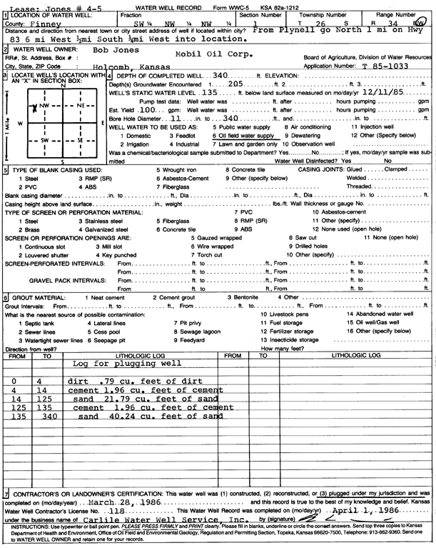
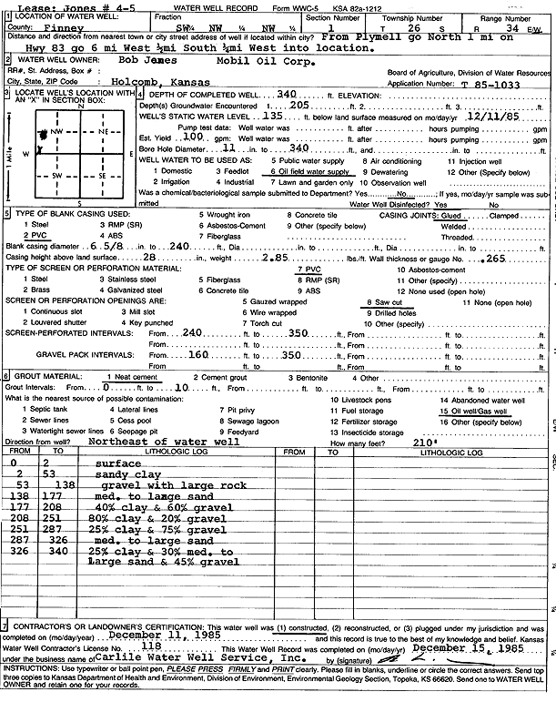
T26S, R34W, Sec. 1 SW NW NW |
Mobil Oil Corp./Bob Jones | 340 ft. | 135 ft. | 100 gpm. | Oil Field Water Supply | Jones 4-5 | Plugged | 28-Mar-1986 | Scan |
|
T26S, R34W, Sec. 1 SW NW NW |
Mobil Oil Corp./Bob Jones | 340 ft. | 135 ft. | 100 gpm. | Oil Field Water Supply | Jones 4-5 | Constructed | 11-Dec-1985 | Scan |
|
T26S, R34W, Sec. 1 NW SE SW |
Rocking T Ranch LLC | 618 ft. | 322 ft. | 322 gpm. | Irrigation | Constructed | 18-Sep-2025 |
KOLAR |
|
|
T26S, R34W, Sec. 2 NW SE SE |
Duane and Kathleen Koster Trusts | 647 ft. | 328 ft. | 750 gpm. | Irrigation | Constructed | 17-Aug-2023 |
KOLAR |
|
|
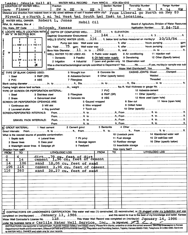
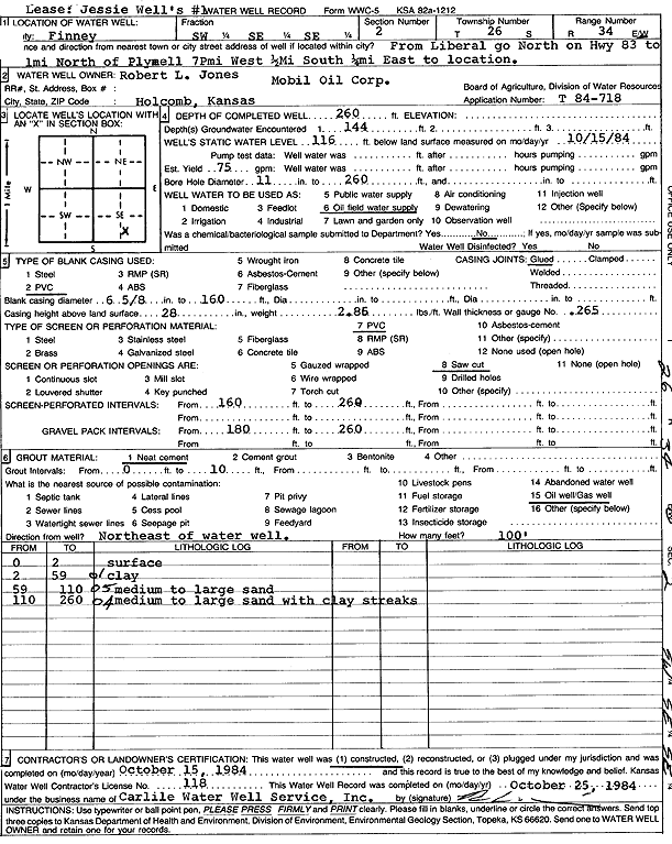
T26S, R34W, Sec. 2 SW SE SE |
Jones, Robert L. | 260 ft. | 116 ft. | 75 gpm. | Oil Field Water Supply | Jessie Walls 1 | Plugged | 13-Jan-1986 | Scan |
|
T26S, R34W, Sec. 2 SW SE SE |
Jones, Robert L. | 260 ft. | 116 ft. | 75 gpm. | Oil Field Water Supply | Jessie Walls 1 | Constructed | 15-Oct-1984 | Scan |
|
T26S, R34W, Sec. 2 NE SW NE |
Jones, Taylor | 375 ft. | 96 ft. | 1450 gpm. | Irrigation | Constructed | 30-Jun-1979 | Scan | |
|
T26S, R34W, Sec. 2 NW SW NW |
Kirk, Henry | 425 ft. | 91 ft. | 1425 gpm. | Irrigation | Constructed | 12-May-1977 | Scan | |
|
T26S, R34W, Sec. 2 NW SE SE |
Koster, Duane | 450 ft. | 130 ft. | 1350 gpm. | Irrigation | Constructed | 31-Aug-1979 | Scan | |
|
T26S, R34W, Sec. 2 NW SE SW |
Koster, Duane | 374 ft. | 118 ft. | 1500 gpm. | Irrigation | Constructed | 31-Aug-1979 | Scan | |
|
T26S, R34W, Sec. 2 NE |
Wheatland Water Treatment | 375 ft. | 150 ft. | Irrigation | Plugged | 22-Jul-2010 | |||
|
T26S, R34W, Sec. 2 NE NE SE NW |
Wheatland Water Treatment | 496 ft. | 237 ft. | Public Water Supply | Constructed | 15-Apr-2010 | |||
|
T26S, R34W, Sec. 3 NW SE NW |
Jones, Taylor | 312 ft. | 60 ft. | 1400 gpm. | Irrigation | Constructed | 01-Mar-1976 | Scan | |
|
T26S, R34W, Sec. 3 NE SE NW |
Kirk, Henry | 410 ft. | 89 ft. | 1950 gpm. | Irrigation | Constructed | 12-May-1977 | Scan | |
|
T26S, R34W, Sec. 3 NW NW NE |
Kirk, Henry | 253 ft. | 100 ft. | Domestic, Livestock | Constructed | 09-Sep-1977 | Scan | ||
|
T26S, R34W, Sec. 3 SE |
Koster, Duane | 363 ft. | 102 ft. | 1500 gpm. | Irrigation | Constructed | 30-May-1979 | Scan | |
|
T26S, R34W, Sec. 3 SW |
Koster, Duane | 355 ft. | 100 ft. | 1500 gpm. | Irrigation | Constructed | 30-May-1979 | Scan | |
|
T26S, R34W, Sec. 3 SE NW NW |
Unruh, Clayton L. | 420 ft. | 206 ft. | Irrigation | Constructed | 09-Nov-2002 | Scan | ||
|
T26S, R34W, Sec. 4 C NE NW |
Jones, Robert L. | 260 ft. | 118 ft. | 100 gpm. | Oil Field Water Supply | Jones Unit 3-2 | Constructed | 18-Feb-1985 | Scan |
|
T26S, R34W, Sec. 4 SE SE NE |
Kenneth, Ralph/Robinson, David | 430 ft. | 210 ft. | Irrigation | Well 28 | Constructed | 07-Sep-2004 | ||
|
T26S, R34W, Sec. 4 NW NE NW |
Kenneth, Ralph/Robinson, David | 435 ft. | 190 ft. | Irrigation | Constructed | 28-Feb-2002 | Scan | ||
|
T26S, R34W, Sec. 4 SW NW NW |
Kenneth, Ralph/Robinson, David | 380 ft. | 198.5 ft. | Irrigation | Constructed | 27-Jan-2003 | Scan | ||
|
T26S, R34W, Sec. 4 SW NE SW |
Kenneth, Ralph/Robinson, David | 360 ft. | 192 ft. | Irrigation | Constructed | 28-Feb-2002 | Scan | ||
|
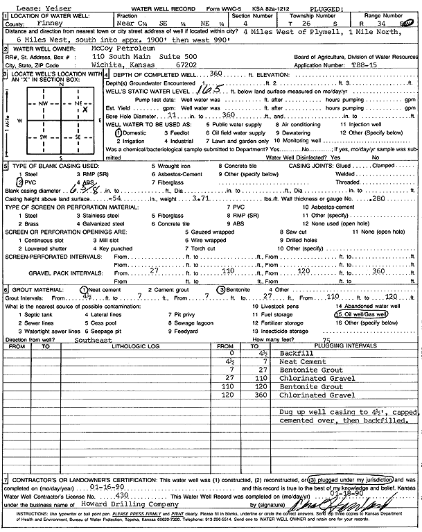
T26S, R34W, Sec. 4 NC SE NE |
McCoy Petroleum | 360 ft. | 165 ft. | Domestic | Yeiser | Plugged | 16-Jan-1990 | Scan | |
|
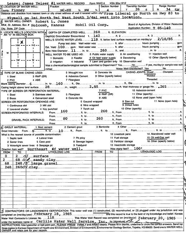
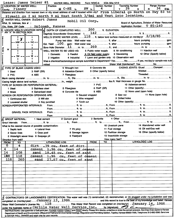
T26S, R34W, Sec. 4 C NE NW |
Mobil Oil Corp./Robert James | 260 ft. | 118 ft. | 100 gpm. | Oil Field Water Supply | James Yeiser 1 | Plugged | 13-Jan-1986 | Scan |
|
T26S, R34W, Sec. 4 NW SE NE NW |
Neufeld, Jacob | 420 ft. | 263 ft. | 250 gpm. | Irrigation | Constructed | 07-Dec-2015 |
KOLAR |
|
|
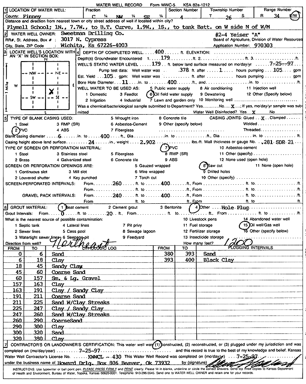
T26S, R34W, Sec. 4 C NW SE |
Sweetman Drilling Co. | 400 ft. | 179 ft. | Oil Field Water Supply | Yeiser A 2-4 | Constructed | 25-Jul-1997 | Scan | |
|
T26S, R34W, Sec. 4 NE NE SW |
Sweetman Drilling Co. | 290 ft. | 140 ft. | Oil Field Water Supply | Constructed | 12-Jan-1988 | Scan | ||
|
T26S, R34W, Sec. 4 NW SW NE SW |
Wheatland Electric Coop | 415 ft. | 260 ft. | 345 gpm. | Irrigation | Constructed | 26-Apr-2015 |
KOLAR |
|
|
T26S, R34W, Sec. 4 SW NW SE SE |
Wheatland Electric Cooperative | 437 ft. | 269 ft. | 326 gpm. | Irrigation | Constructed | 28-Apr-2015 |
KOLAR |
|
|
T26S, R34W, Sec. 4 NE |
Wheatland Water Treatment | 209 ft. | Public Water Supply | Plugged | 29-Nov-2010 | ||||
|
T26S, R34W, Sec. 4 NE NE NE |
Wheatland Water Treatment | 465 ft. | Public Water Supply | Constructed | 20-Jun-2010 | ||||
|
T26S, R34W, Sec. 5 SW SW NE |
Jones Farms, Inc. | 420 ft. | 205 ft. | Irrigation | Constructed | 28-Mar-2002 | Scan | ||
|
T26S, R34W, Sec. 5 NW NW NE |
Jones Farms, Inc. | 400 ft. | 201 ft. | Irrigation | Constructed | 20-Mar-2003 | Scan | ||
|
T26S, R34W, Sec. 5 SW |
Jones, Taylor | 390 ft. | 112 ft. | 1500 gpm. | Irrigation | Constructed | 29-Apr-1979 | Scan | |
|
T26S, R34W, Sec. 5 NW |
Jones, Taylor | 294 ft. | 88 ft. | 1500 gpm. | Irrigation | Constructed | 29-Apr-1979 | Scan | |
|
T26S, R34W, Sec. 5 NE SE SW NW |
Sandyhill Enterprises LLC | 600 ft. | 278 ft. | 375 gpm. | Irrigation | Constructed | 13-Mar-2019 |
KOLAR |
|
|
T26S, R34W, Sec. 5 NE NE NE |
Wheatland Water Treatment | 468 ft. | 235 ft. | Public Water Supply | Constructed | 10-Jul-2010 | |||
|
T26S, R34W, Sec. 5 NE |
Wheatland Water Treatment | 385 ft. | 233 ft. | Public Water Supply | Plugged | 29-Nov-2010 | |||
|
T26S, R34W, Sec. 6 NW SE SW |
Reeve, M. P. | 344 ft. | 121 ft. | 1500 gpm. | Irrigation | Constructed | 05-Oct-1979 | Scan | |
|
T26S, R34W, Sec. 6 NW |
Reeve, M. P. | 395 ft. | 155 ft. | 1550 gpm. | Irrigation | Constructed | 29-Aug-1979 | Scan | |
|
T26S, R34W, Sec. 6 SE |
Reeve, M. P. | 330 ft. | 135 ft. | 1550 gpm. | Irrigation | Constructed | 10-Oct-1979 | Scan | |
| View page: < Prev || 101 || 102 || 103 || 104 || 105 || 106 || 107 || 108 || 109 || 110 | |||||||||