Select location of well to view details.
Click on column heading to sort.
|
|
|
County: Finney Select location of well to view details. Click on column heading to sort. |
|
|
|
| View page: < Prev || 101 || 102 || 103 || 104 || 105 || 106 || 107 || 108 || 109 || 110 | |||||||||
| T-R-S | Owner | Well Depth Ascend. Desc. |
Static Water Level Ascend. Desc. |
Est. Yield Ascend. Desc. |
Well Use | Other ID | Action Taken | Completion Date Ascend. Desc. |
Scan? |
|
T26S, R34W, Sec. 7 SW |
O'Neal, John | 337 ft. | 110 ft. | 1250 gpm. | Irrigation | Constructed | 12-Mar-1980 | Scan | |
|
T26S, R34W, Sec. 7 NW |
O'Neal, John | 330 ft. | 120 ft. | 1500 gpm. | Irrigation | Constructed | 12-Mar-1980 | Scan | |
|
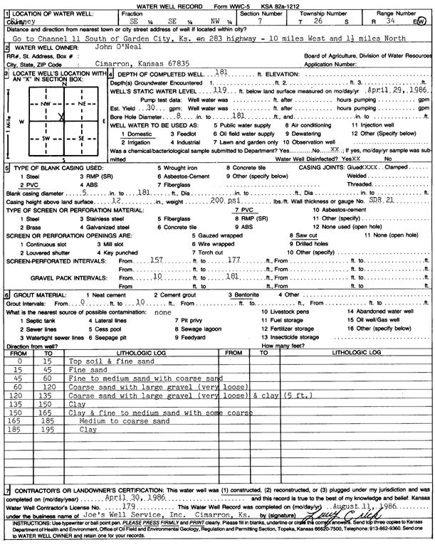
T26S, R34W, Sec. 7 SE SE NW |
O'Neal, John | 181 ft. | 119 ft. | 30 gpm. | Domestic | Constructed | 30-Apr-1986 | Scan | |
|
T26S, R34W, Sec. 7 SE |
O'Neal, John | 405 ft. | 120 ft. | 1300 gpm. | Irrigation | Constructed | 29-Feb-1980 | Scan | |
|
T26S, R34W, Sec. 7 NE |
O'Neal, John | 335 ft. | 125 ft. | 1250 gpm. | Irrigation | Constructed | 29-Feb-1980 | Scan | |
|
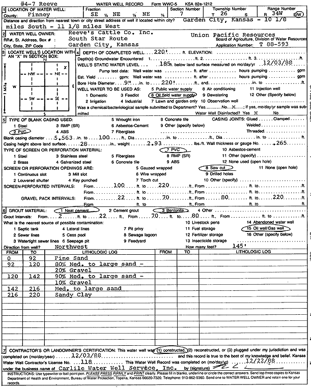
T26S, R34W, Sec. 7 SE NE NE |
Reeve's Cattle Co., Inc. | 220 ft. | 185 ft. | Oil Field Water Supply | Reeve 4-7 | Constructed | 03-Dec-1988 | Scan | |
|
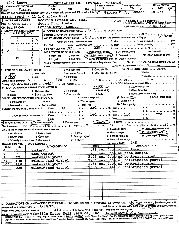
T26S, R34W, Sec. 7 SE NE NE |
Reeve's Cattle Co., Inc. | 220 ft. | 185 ft. | Oil Field Water Supply | Reeve 4-7 | Plugged | 10-Jan-1989 | Scan | |
|
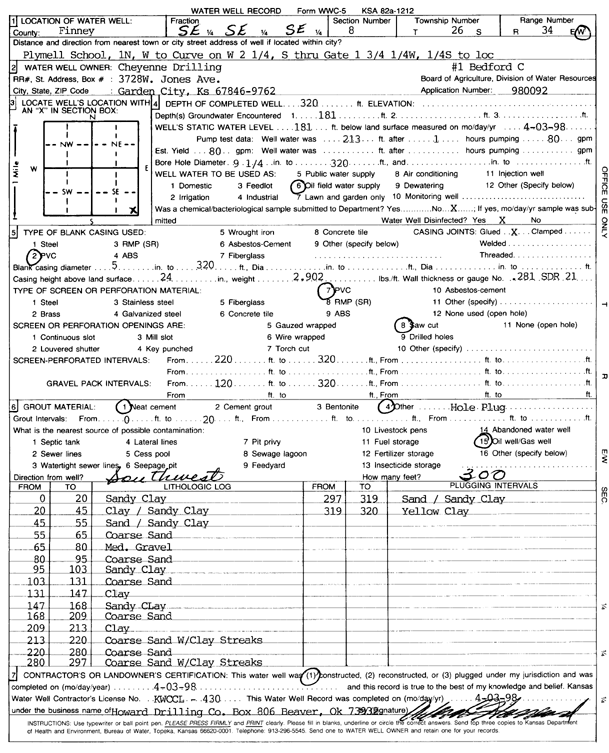
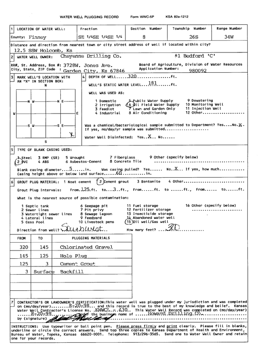
T26S, R34W, Sec. 8 SE SE SE |
Cheyenne Drilling | 320 ft. | 181 ft. | Oil Field Water Supply | Bedford C-1 | Constructed | 03-Apr-1998 | Scan | |
|
T26S, R34W, Sec. 8 SE SE SE |
Cheyenne Drilling Co. | 320 ft. | 181 ft. | Oil Field Water Supply | Bedford C-1 | Plugged | 20-Aug-1998 | Scan | |
|
T26S, R34W, Sec. 8 NE |
Jones, Taylor | 303 ft. | 103 ft. | 1500 gpm. | Irrigation | Constructed | 29-Apr-1979 | Scan | |
|
T26S, R34W, Sec. 8 NW |
Koster, Duane | 408 ft. | 408 ft. | 1450 gpm. | Irrigation | Constructed | 30-Sep-1979 | Scan | |
|
T26S, R34W, Sec. 8 SW |
Koster, Duane | 345 ft. | 141 ft. | 1500 gpm. | Irrigation | Constructed | 05-Oct-1979 | Scan | |
|
T26S, R34W, Sec. 8 SE |
Koster, Duane | 380 ft. | 131 ft. | 1500 gpm. | Irrigation | Constructed | 31-Aug-1979 | Scan | |
|
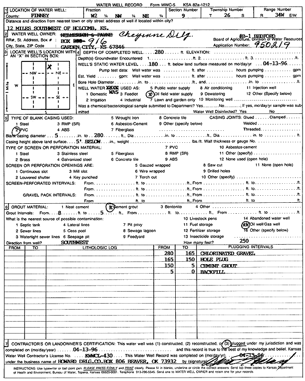
T26S, R34W, Sec. 9 W2 NW NE |
Cheyenne Drilling | 280 ft. | 180 ft. | Oil Field Water Supply | Bedford B 1 | Plugged | 13-Apr-1996 | Scan | |
|
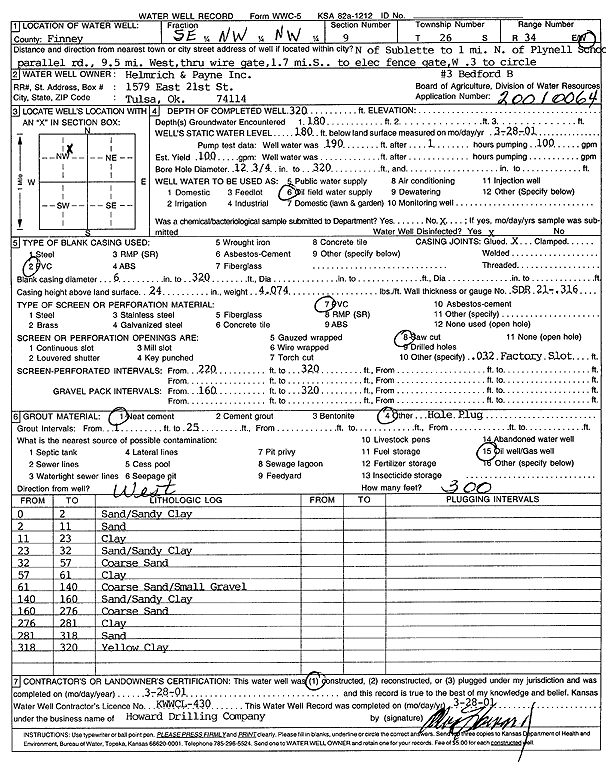
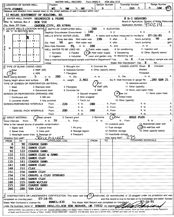
T26S, R34W, Sec. 9 SE NW NW |
Helmerich and Payne Inc. | 320 ft. | 180 ft. | Oil Field Water Supply | Bedford B 3 | Constructed | 28-Mar-2001 | Scan | |
|
T26S, R34W, Sec. 9 W2 NW NE |
Helmerich and Payne Inc. | 280 ft. | 180 ft. | 90 gpm. | Oil Field Water Supply | Bedford B 1 | Constructed | 14-Jul-1995 | Scan |
|
T26S, R34W, Sec. 9 NW NE SE |
Reeve, M. P. | 409 ft. | 94 ft. | 1500 gpm. | Irrigation | Constructed | 03-Feb-1977 | Scan | |
|
T26S, R34W, Sec. 9 SW |
Reeve, M. P. | 367 ft. | 99 ft. | 1600 gpm. | Irrigation | Constructed | 31-Mar-1978 | Scan | |
|
T26S, R34W, Sec. 10 NW SE NE |
Duane E Koster Trust and Kathleen A Koster Trust | 318 ft. | 250 ft. | Irrigation | Plugged | 12-Jul-2012 | |||
|
T26S, R34W, Sec. 10 NW SE NE |
Duane E. and Kathleen A. Koster Trusts | 470 ft. | 251 ft. | Irrigation | Test 1 | Constructed | 13-Apr-2012 | ||
|
T26S, R34W, Sec. 10 SE |
Koster, Duane | 334 ft. | 113 ft. | 1500 gpm. | Irrigation | Constructed | 30-May-1979 | Scan | |
|
T26S, R34W, Sec. 10 SW |
Koster, Duane | 379 ft. | 100 ft. | 1500 gpm. | Irrigation | Constructed | 30-May-1979 | Scan | |
|
T26S, R34W, Sec. 10 NE |
Koster, Duane | 318 ft. | 98 ft. | 1500 gpm. | Irrigation | Constructed | 30-May-1979 | Scan | |
|
T26S, R34W, Sec. 10 NW |
Koster, Duane | 384 ft. | 97 ft. | 1300 gpm. | Irrigation | Constructed | 30-May-1978 | Scan | |
|
T26S, R34W, Sec. 10 NE NE SW SW |
Sandyhill Enterprises LLC | 614 ft. | 280 ft. | 400 gpm. | Irrigation | Constructed | 16-Dec-2020 |
KOLAR |
|
|
T26S, R34W, Sec. 10 NE SW NW NW |
Sandyhill Enterprises LLC | 590 ft. | 294 ft. | 500 gpm. | Irrigation | Constructed | 01-Jul-2019 |
KOLAR |
|
|
T26S, R34W, Sec. 11 NW |
Koster, Duane | 365 ft. | 105 ft. | 1500 gpm. | Irrigation | Constructed | 30-May-1979 | Scan | |
|
T26S, R34W, Sec. 11 SE NW NE |
Koster, Duane | 394 ft. | 115 ft. | 1500 gpm. | Irrigation | Constructed | 31-Aug-1979 | Scan | |
|
T26S, R34W, Sec. 11 SE |
Koster, Duane | 363 ft. | 108 ft. | 1500 gpm. | Irrigation | Constructed | 31-Aug-1979 | Scan | |
|
T26S, R34W, Sec. 11 SE SE NW NE |
Sandy Acres LLC | 558 ft. | 299 ft. | 450 gpm. | Irrigation | Constructed | 15-Jul-2020 |
KOLAR |
|
|
T26S, R34W, Sec. 11 SW |
SCS Farms | 347 ft. | 120 ft. | 1500 gpm. | Irrigation | Constructed | 29-Feb-1980 | Scan | |
|
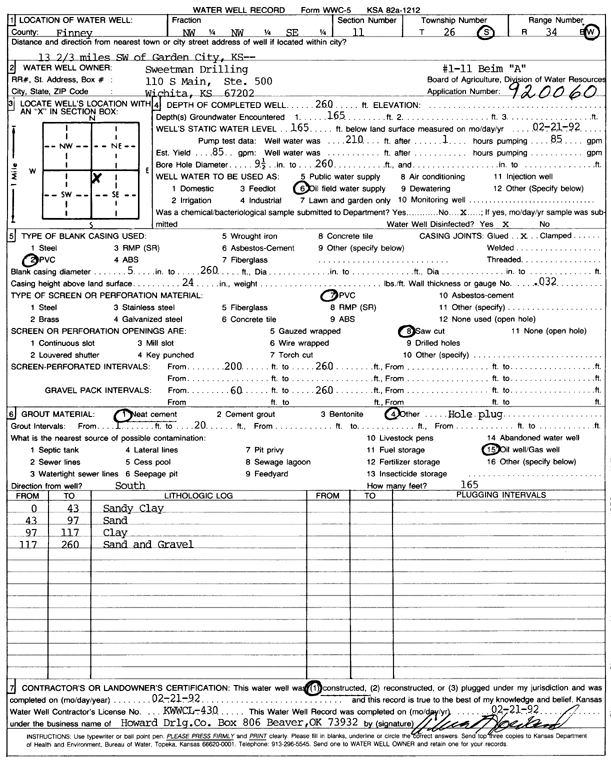
T26S, R34W, Sec. 11 NW NW SE |
Sweetman Drilling Co. | 260 ft. | 165 ft. | 85 gpm. | Oil Field Water Supply | Beim A 1-11 | Constructed | 21-Feb-1992 | Scan |
|
T26S, R34W, Sec. 11 NW NW NW |
Wheatland Electric Cooperative Inc | 457 ft. | 236 ft. | Irrigation | Constructed | 24-Nov-2008 | |||
|
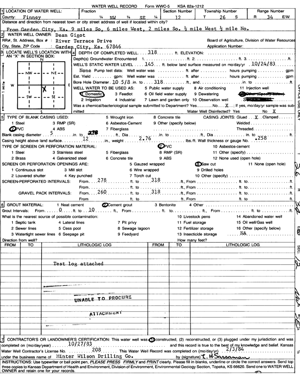
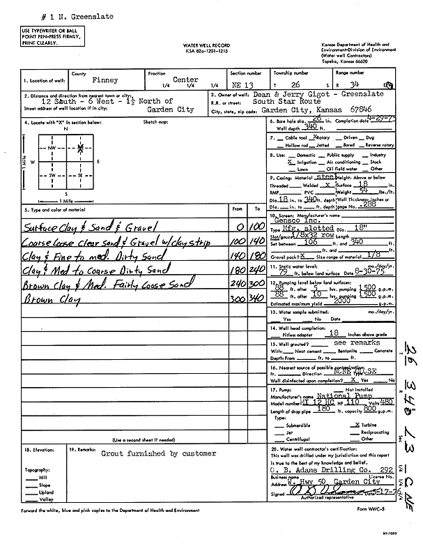
T26S, R34W, Sec. 12 NW SE |
Gigot, Dean | 318 ft. | 145 ft. | Domestic | Constructed | 27-Oct-1983 | Scan | ||
|
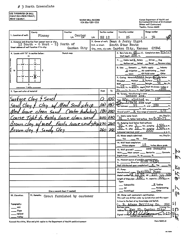
T26S, R34W, Sec. 12 C SE |
Gigot, Dean and Jerry | 280 ft. | 81 ft. | 2000 gpm. | Irrigation | Constructed | 01-Apr-1975 | Scan | |
|
T26S, R34W, Sec. 12 NE SE NE NE |
JBZ Forages | 390 ft. | 230 ft. | 100 gpm. | Domestic, Livestock | Constructed | 31-Jul-2015 |
KOLAR |
|
|
T26S, R34W, Sec. 12 NW NW NW |
Koster, Duane | 450 ft. | 228 ft. | Irrigation | Constructed | 03-Jun-2004 | Scan | ||
|
T26S, R34W, Sec. 12 NW SE NE |
Koster, Duane | 378 ft. | 101 ft. | 1500 gpm. | Irrigation | Constructed | 31-Aug-1979 | Scan | |
|
T26S, R34W, Sec. 12 C NW |
Koster, Duane | 295 ft. | 205 ft. | Irrigation | Plugged | 12-May-2005 | |||
|
T26S, R34W, Sec. 12 SE NW NW |
Koster, Duane | 295 ft. | 125 ft. | 1400 gpm. | Irrigation | Constructed | 31-Aug-1979 | Scan | |
|
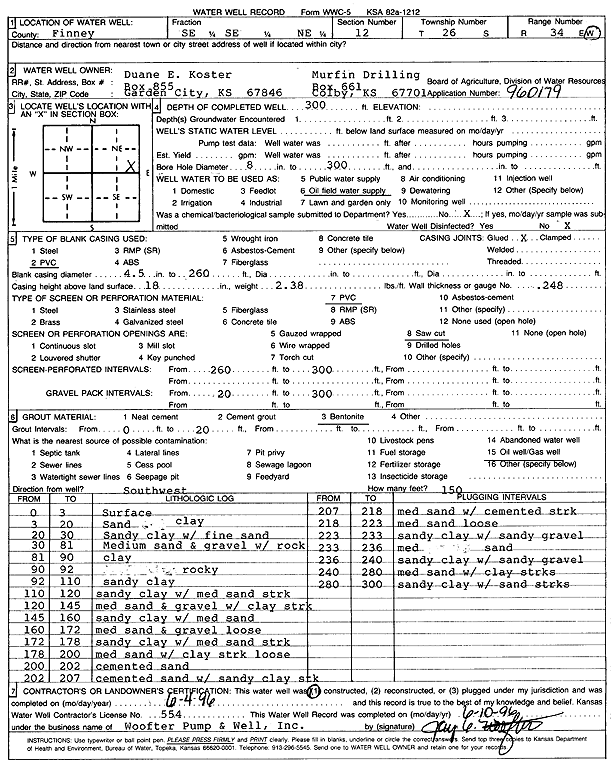
T26S, R34W, Sec. 12 SE SE NE |
Murfin Drilling/Koster, Duane E. | 300 ft. | Oil Field Water Supply | Constructed | 04-Jun-1996 | Scan | |||
|
T26S, R34W, Sec. 12 SW SE SW |
Sandyhill Enterprises LLC | 545 ft. | 312 ft. | Irrigation | Constructed | 25-May-2023 |
KOLAR |
||
|
T26S, R34W, Sec. 12 SE SE SE SE |
Sandyhill Enterprises LLC | 550 ft. | 269 ft. | 50 gpm. | Irrigation | Constructed | 01-Apr-2020 |
KOLAR |
|
|
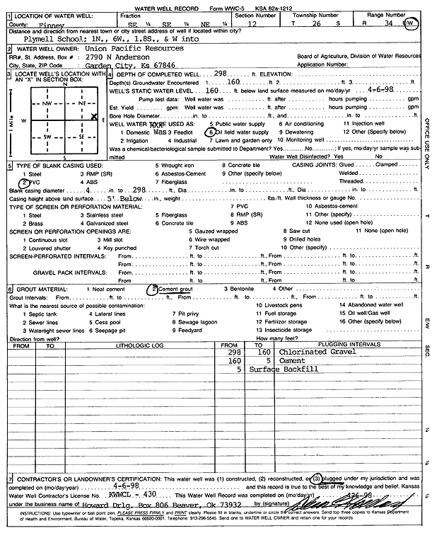
T26S, R34W, Sec. 12 SE SE NE |
Union Pacific Resources Co. | 298 ft. | 160 ft. | Oil Field Water Supply | Plugged | 06-Apr-1998 | Scan | ||
|
T26S, R34W, Sec. 12 NW NW SW |
Wheatland Electric Coop Inc | 470 ft. | 252 ft. | Irrigation | Constructed | 07-Mar-2009 | |||
|
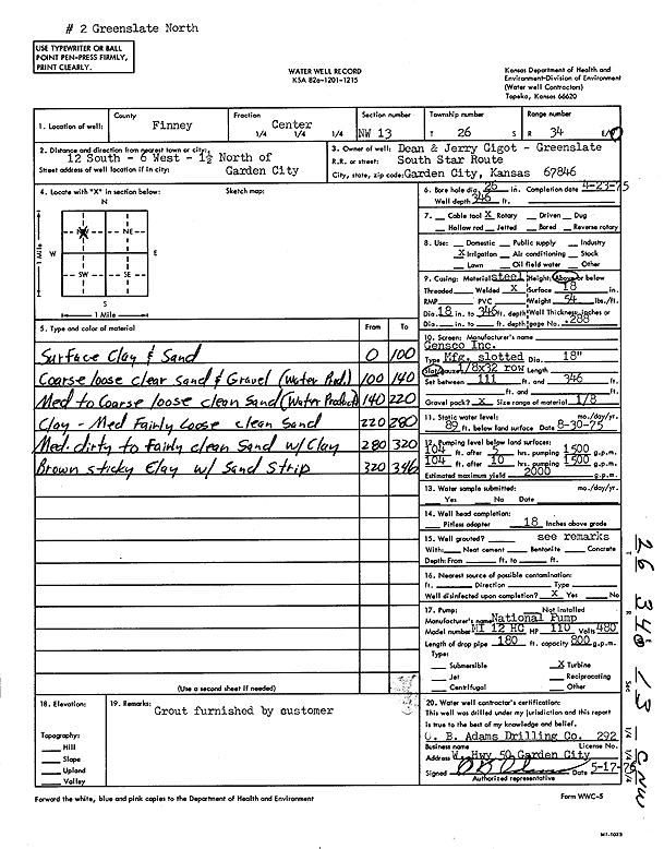
T26S, R34W, Sec. 13 C NE |
Gigot, Dean and Jerry | 340 ft. | 79 ft. | 2000 gpm. | Irrigation | Constructed | 29-Apr-1975 | Scan | |
|
T26S, R34W, Sec. 13 C NW |
Gigot, Dean and Jerry | 346 ft. | 89 ft. | 2000 gpm. | Irrigation | Constructed | 23-Apr-1975 | Scan | |
|
T26S, R34W, Sec. 13 NE NE SE |
Heide, Henry | 455 ft. | 185 ft. | Domestic | Constructed | 21-Dec-2022 |
KOLAR |
||
|
T26S, R34W, Sec. 13 NW SW SW NE |
Sandy Acres, LLC | 586 ft. | 262 ft. | 506 gpm. | Irrigation | Constructed | 25-Mar-2020 |
KOLAR |
|
|
T26S, R34W, Sec. 13 NW NW SE NW |
Sandyhill Enterprises LLC | 568 ft. | 266 ft. | 500 gpm. | Irrigation | Constructed | 10-Jul-2019 |
KOLAR |
|
| View page: < Prev || 101 || 102 || 103 || 104 || 105 || 106 || 107 || 108 || 109 || 110 | |||||||||