Select location of well to view details.
Click on column heading to sort.
|
|
|
County: Finney Select location of well to view details. Click on column heading to sort. |
|
|
|
| View page: < Prev || 51 || 52 || 53 || 54 || 55 || 56 || 57 || 58 || 59 || 60 || Next > | |||||||||
| T-R-S | Owner | Well Depth Ascend. Desc. |
Static Water Level Ascend. Desc. |
Est. Yield Ascend. Desc. |
Well Use | Other ID | Action Taken | Completion Date Ascend. Desc. |
Scan? |
|
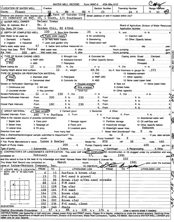
T24S, R32W, Sec. 25 SE NW NW |
Towns, Delmer | 230 ft. | 47 ft. | 500 gpm. | Public Water Supply | Constructed | 17-Feb-1981 | Scan | |
|
T24S, R32W, Sec. 25 SE NE NW |
Towns, Delmer | 240 ft. | 70 ft. | Irrigation | Plugged | 01-Oct-2007 | |||
|
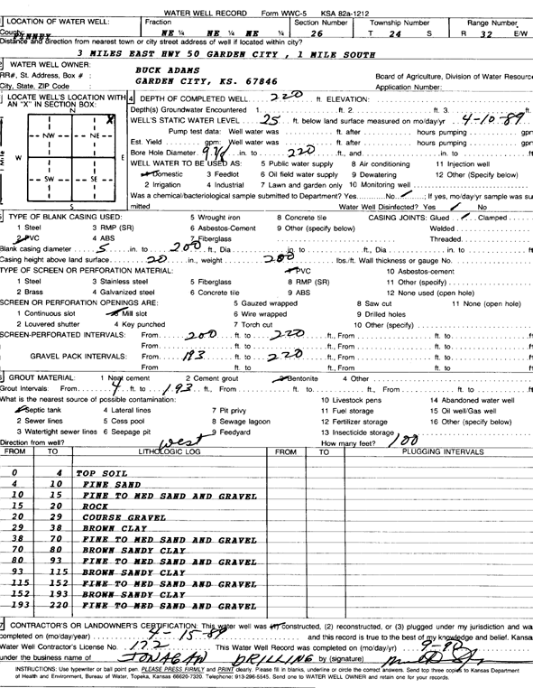
T24S, R32W, Sec. 26 NE NE NE |
Adams, Buck | 220 ft. | 25 ft. | Domestic | Constructed | 15-Apr-1989 | Scan | ||
|
T24S, R32W, Sec. 26 SW NE SW |
Brookover | 215 ft. | 14 ft. | 1600 gpm. | Irrigation | Constructed | 26-Apr-1977 | Scan | |
|
T24S, R32W, Sec. 26 NW NE NE |
City of Garden City | 39 ft. | Irrigation | Plugged | 30-Mar-2019 | ||||
|
T24S, R32W, Sec. 26 NW NW NE |
City of Garden City | 232 ft. | 55 ft. | Industrial | Plugged | 30-Mar-2019 | |||
|
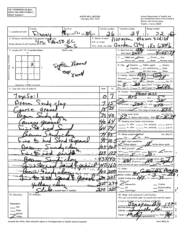
T24S, R32W, Sec. 26 NE SW NE |
Haunschild, Norman | 240 ft. | 37 ft. | Domestic | Constructed | 25-Apr-1979 | Scan | ||
|
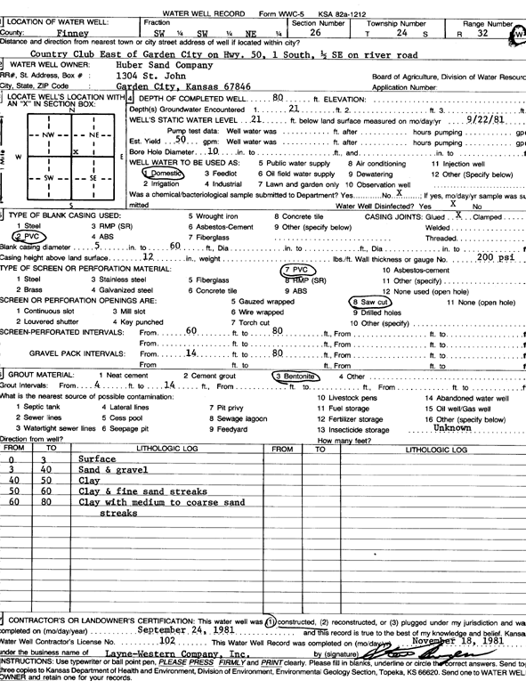
T24S, R32W, Sec. 26 SW SW NE |
Huber Sand Co. | 80 ft. | 21 ft. | 50 gpm. | Domestic | Constructed | 24-Sep-1981 | Scan | |
|
T24S, R32W, Sec. 26 NC S2 N2 |
Huber Sand, Inc. | 220 ft. | 25 ft. | Industrial | Constructed | 06-Oct-1997 | Scan | ||
|
T24S, R32W, Sec. 26 SE SW NW |
JBS USA | 25.37 ft. | 12.1 ft. | Monitoring well/observation/piezometer | MW 14 | Plugged | 07-May-2019 | ||
|
T24S, R32W, Sec. 26 SW SW SE |
JBS USA | 26.95 ft. | 9.55 ft. | Monitoring well/observation/piezometer | MW 13 | Plugged | 07-May-2019 | ||
|
T24S, R32W, Sec. 26 NW SE SW |
JBS USA | 25.52 ft. | 8.34 ft. | Monitoring well/observation/piezometer | MW 12 | Plugged | 07-May-2019 | ||
|
T24S, R32W, Sec. 26 NW SW SE |
JBS USA | 32.55 ft. | 11.55 ft. | Monitoring well/observation/piezometer | MW 21 | Plugged | 07-May-2019 | ||
|
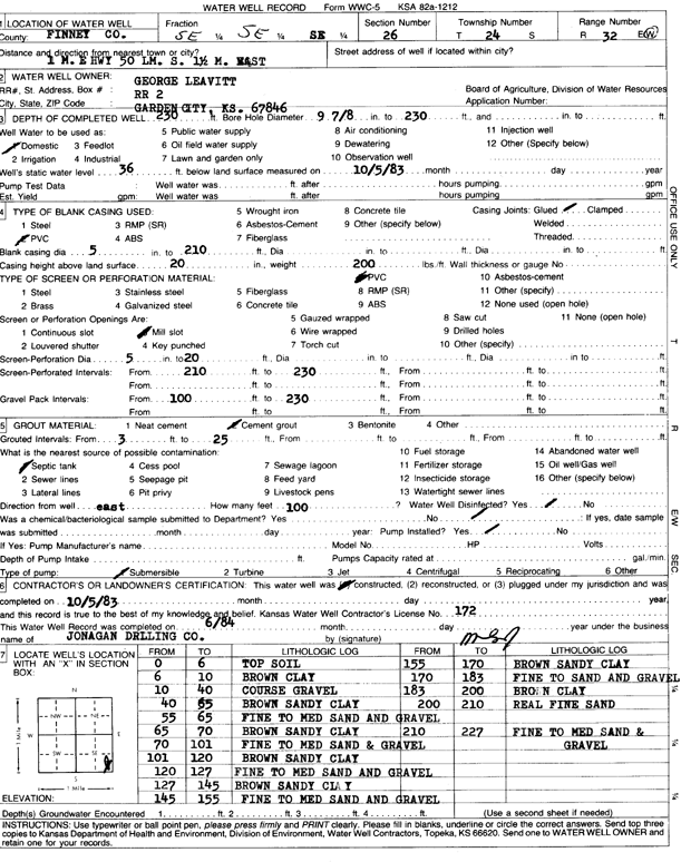
T24S, R32W, Sec. 26 SE |
Leavitt, George | 230 ft. | 36 ft. | Domestic | Constructed | 05-Oct-1983 | Scan | ||
|
T24S, R32W, Sec. 26 NE NE SE |
Miller Enterprises, Inc. | 675 ft. | 157 ft. | Public Water Supply | Constructed | 03-Dec-2001 | Scan | ||
|
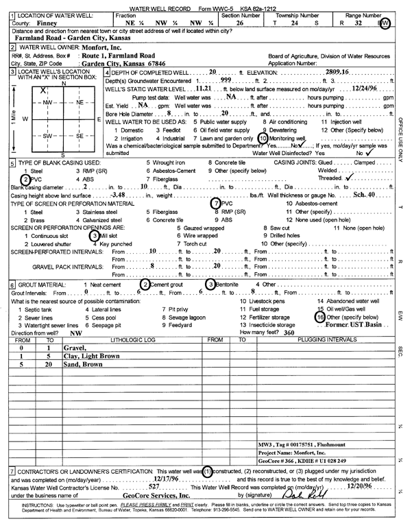
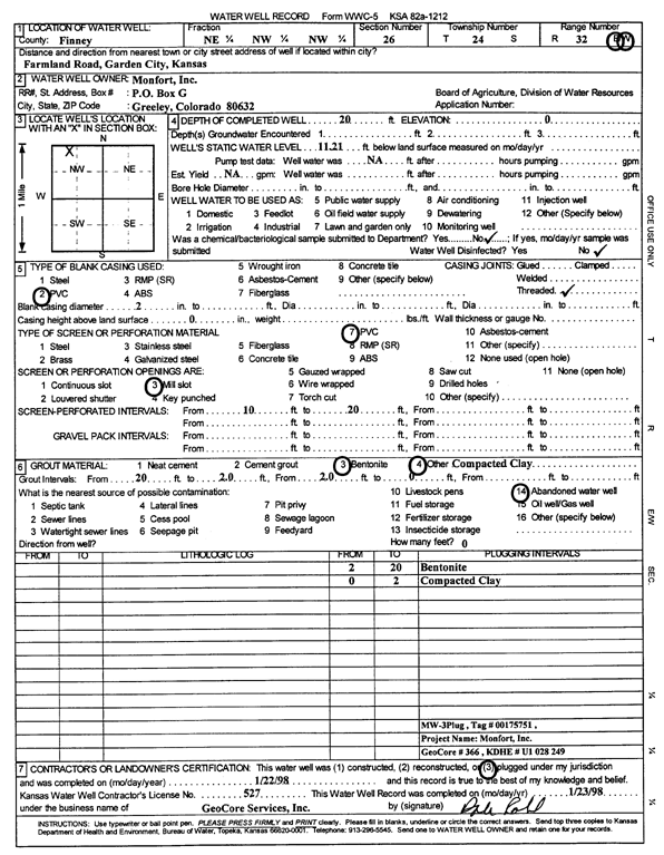
T24S, R32W, Sec. 26 NE NW NW |
Monfort, Inc. | 20 ft. | 11.21 ft. | Monitoring well/observation/piezometer | MW 3 | Constructed | 17-Dec-1996 | Scan | |
|
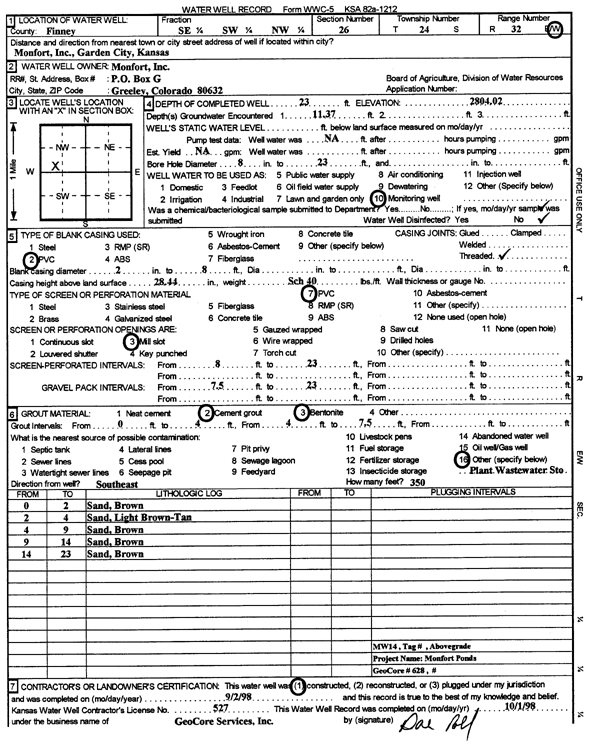
T24S, R32W, Sec. 26 SE SW NW |
Monfort, Inc. | 23 ft. | 11.37 ft. | Monitoring well/observation/piezometer | MW 14 | Constructed | 02-Sep-1998 | Scan | |
|
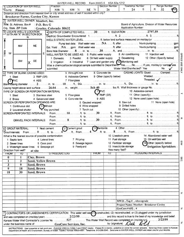
T24S, R32W, Sec. 26 NW SW SE |
Monfort, Inc. | 30 ft. | Monitoring well/observation/piezometer | MW 21 | Constructed | 23-Feb-1999 | Scan | ||
|
T24S, R32W, Sec. 26 NE NW NW |
Monfort, Inc. | 20 ft. | 11.21 ft. | Monitoring well/observation/piezometer | MW 3 | Plugged | 22-Jan-1998 | Scan | |
|
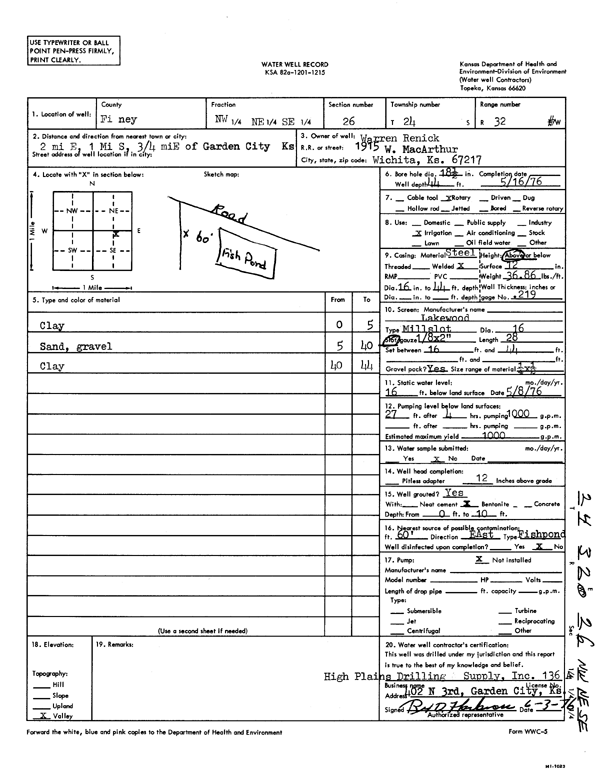
T24S, R32W, Sec. 26 NW NE SE |
Renick, Warren | 44 ft. | 16 ft. | 1000 gpm. | Irrigation | Constructed | 16-May-1976 | Scan | |
|
T24S, R32W, Sec. 26 C N2 NW |
Stinemetz, Delbert | 223 ft. | 37 ft. | 1850 gpm. | Irrigation | Constructed | 09-Nov-1982 | Scan | |
|
T24S, R32W, Sec. 26 NE NW NW |
Swift Independent Corp. | 47 ft. | 12 ft. | Monitoring well/observation/piezometer | MW 9 | Constructed | 23-Jan-1988 | Scan | |
|
T24S, R32W, Sec. 26 SE NE NW |
Swift Independent Corp. | 90 ft. | 12 ft. | Monitoring well/observation/piezometer | MW 10 | Constructed | 22-Jan-1988 | Scan | |
|
T24S, R32W, Sec. 26 SW SW SE |
Swift Independent Corp. | 27 ft. | Monitoring well/observation/piezometer | MW 13 | Constructed | 18-Feb-1988 | Scan | ||
|
T24S, R32W, Sec. 26 NW SE SW |
Swift Independent Corp. | 27 ft. | Monitoring well/observation/piezometer | MW 12 | Constructed | 18-Feb-1988 | Scan | ||
|
T24S, R32W, Sec. 26 SE NE NW |
Swift Independent Corp. | 40 ft. | 12 ft. | Monitoring well/observation/piezometer | MW 11 | Constructed | 22-Jan-1988 | Scan | |
|
T24S, R32W, Sec. 27 NE SE NW NW |
Damme Farms LLC | 242 ft. | 67 ft. | 1309 gpm. | Irrigation | Constructed | 09-Jun-2016 |
KOLAR |
|
|
T24S, R32W, Sec. 27 NE NE NW SE |
Damme Farms LLC | 227 ft. | 63 ft. | 675 gpm. | Irrigation | Constructed | 10-Dec-2019 |
KOLAR |
|
|
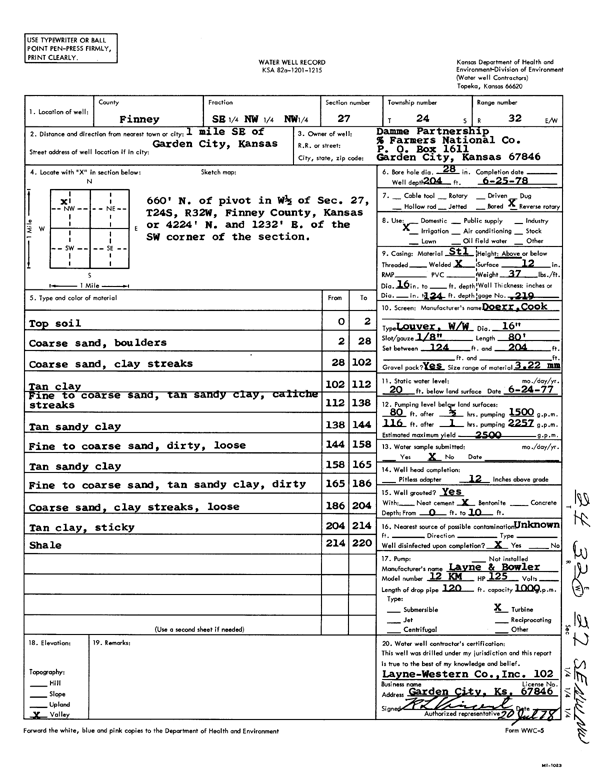
T24S, R32W, Sec. 27 SE NW SE |
Damme Partnership | 198 ft. | 23 ft. | 2500 gpm. | Irrigation | Constructed | 24-Jun-1978 | Scan | |
|
T24S, R32W, Sec. 27 NW SW NE NW |
Damme Partnership | 204 ft. | 197 ft. | Irrigation | Plugged | 07-Jan-2026 | |||
|
T24S, R32W, Sec. 27 NE NE NW SE |
Damme Partnership | 198 ft. | 187 ft. | Irrigation | Plugged | 07-Jan-2026 | |||
|
T24S, R32W, Sec. 27 SE NW NW |
Damme Partnership | 204 ft. | 20 ft. | 2500 gpm. | Irrigation | Constructed | 25-Jun-1978 | Scan | |
|
T24S, R32W, Sec. 27 NE NE NW SE |
Irrigation | MW 2 | Plugged | 07-Jan-2026 | |||||
|
T24S, R32W, Sec. 28 SE NE SW NW |
Damme Partnership | 282 ft. | 256 ft. | Irrigation | Plugged | 07-Jan-2026 | |||
|
T24S, R32W, Sec. 28 NW SE NW |
Damme, Inc. | 282 ft. | 40 ft. | 1100 gpm. | Irrigation | Constructed | 24-May-1975 | Scan | |
|
T24S, R32W, Sec. 28 NE NE SW NW |
William H and Erma C Damme Farms LLC | 293 ft. | 293 ft. | 1015 gpm. | Irrigation | Constructed | 18-Apr-2017 |
KOLAR |
|
|
T24S, R32W, Sec. 28 NE NE SW NW |
William H and Erma C Damme Farms LLC | 293 ft. | 293 ft. | 1015 gpm. | Irrigation | Constructed | 18-Apr-2017 | ||
|
T24S, R32W, Sec. 29 SW SE SE |
Geier, Ed | 300 ft. | 119 ft. | Domestic | Constructed | 06-Oct-2003 | |||
|
T24S, R32W, Sec. 29 SE SW NE |
Kilgore, Richard | 200 ft. | Geothermal, Closed Loop, Vertical | Constructed | 19-Jul-2013 | ||||
|
T24S, R32W, Sec. 29 NE SE NW |
Northern Pump Co. | 280 ft. | 60 ft. | 100 gpm. | Oil Field Water Supply | Constructed | 03-Feb-1986 | Scan | |
|
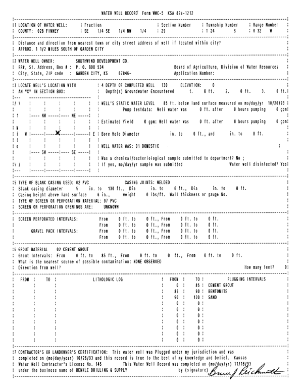
T24S, R32W, Sec. 29 SE NW SE |
South Wind Development Co. | 277 ft. | 70 ft. | Irrigation | Constructed | 25-Oct-1983 | Scan | ||
|
T24S, R32W, Sec. 29 SE SE NW |
South Wind Development Co. | 130 ft. | 85 ft. | Domestic | Plugged | 26-Oct-1993 | Scan | ||
|
T24S, R32W, Sec. 29 SE SE SW |
Sternberger, Jeff | 200 ft. | Heat Pump (Closed Loop/Disposal), Geothermal | Constructed | 26-Aug-2010 | ||||
|
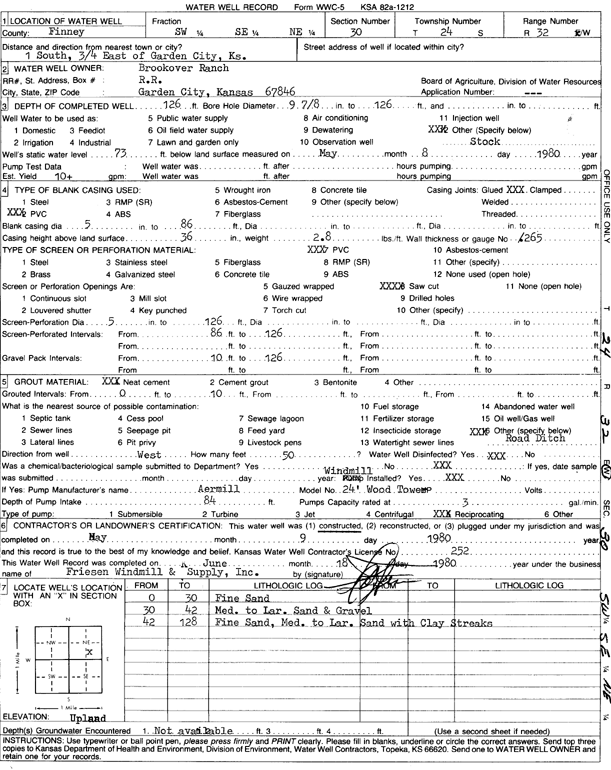
T24S, R32W, Sec. 30 SW SE NE |
Brookover Ranch | 126 ft. | 73 ft. | 10 gpm. | Domestic, Livestock | Constructed | 09-May-1980 | Scan | |
|
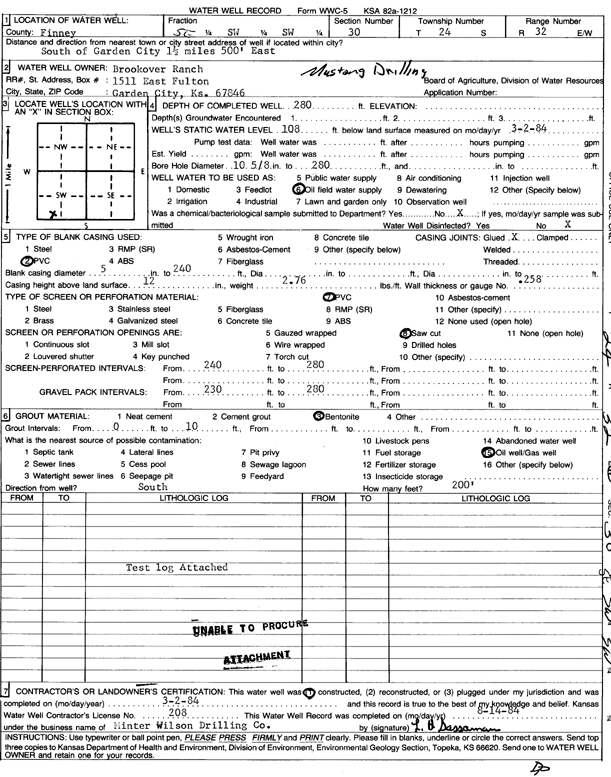
T24S, R32W, Sec. 30 SE SW SW |
Brookover Ranch | 280 ft. | 108 ft. | Oil Field Water Supply | Brookover 1 | Constructed | 02-Mar-1984 | Scan | |
|
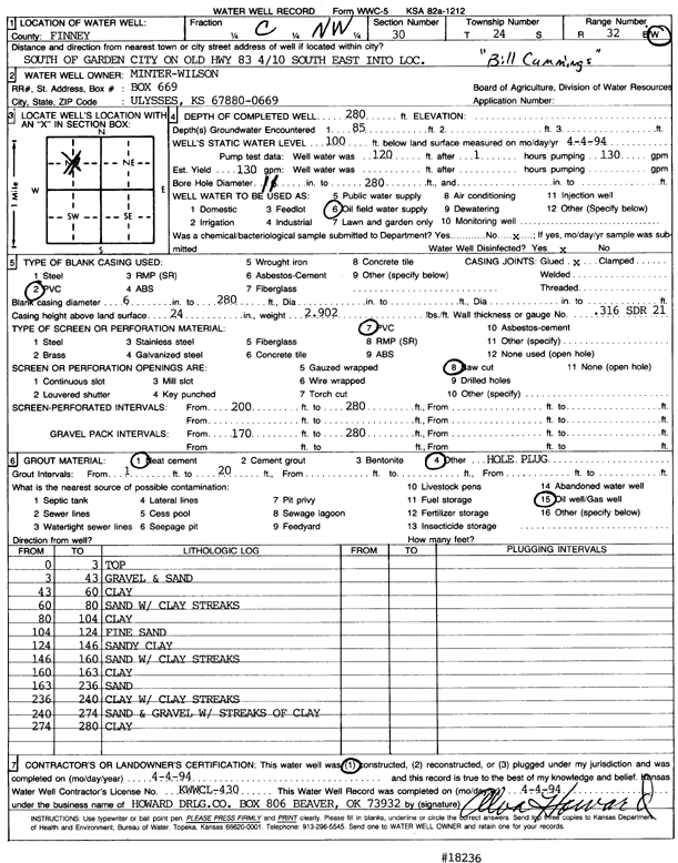
T24S, R32W, Sec. 30 C NW |
Minter-Wilson Drilling Co. | 280 ft. | 100 ft. | 130 gpm. | Oil Field Water Supply | Constructed | 04-Apr-1994 | Scan | |
|
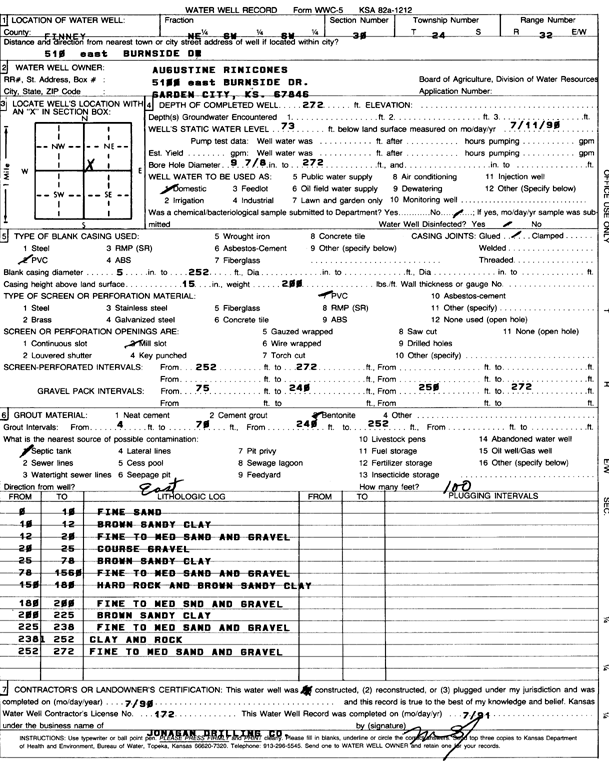
T24S, R32W, Sec. 30 NE SW SW |
Rinicones, Augustine | 272 ft. | 73 ft. | Domestic | Constructed | 01-Jul-1990 | Scan | ||
|
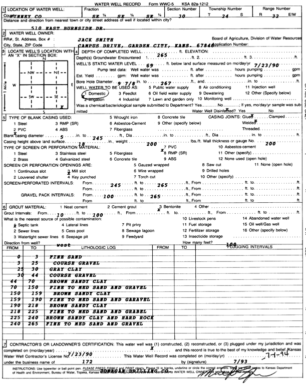
T24S, R32W, Sec. 30 SE SE SE |
Smith, Jack | 265 ft. | 69 ft. | Domestic | Constructed | 23-Jul-1990 | Scan | ||
|
T24S, R32W, Sec. 32 NE SE SE |
Brookover, Earl | 270 ft. | 60 ft. | 1525 gpm. | Irrigation | Constructed | 30-Nov-1978 | Scan | |
|
T24S, R32W, Sec. 32 NE SE NW |
Southwind Development | 342 ft. | 149 ft. | 1500 gpm. | Public Water Supply | Well 2 | Constructed | 13-Feb-2024 |
KOLAR |
| View page: < Prev || 51 || 52 || 53 || 54 || 55 || 56 || 57 || 58 || 59 || 60 || Next > | |||||||||