Select location of well to view details.
Click on column heading to sort.
|
|
|
County: Finney Select location of well to view details. Click on column heading to sort. |
|
|
|
| View page: < Prev || 91 || 92 || 93 || 94 || 95 || 96 || 97 || 98 || 99 || 100 || Next > | |||||||||
| T-R-S | Owner | Well Depth Ascend. Desc. |
Static Water Level Ascend. Desc. |
Est. Yield Ascend. Desc. |
Well Use | Other ID | Action Taken | Completion Date Ascend. Desc. |
Scan? |
|
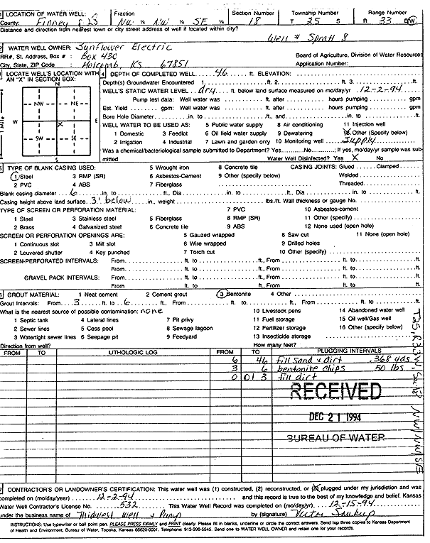
T25S, R33W, Sec. 18 NW NW SE |
Sunflower Electric Power Corp. | 46 ft. | Oil Field Water Supply | Spratt 8 | Plugged | 02-Dec-1994 | Scan | ||
|
T25S, R33W, Sec. 18 SE SE NW |
Sunflower Electric Power Corp. | 437 ft. | 192 ft. | Monitoring well/observation/piezometer | OBS 2 | Constructed | 25-Feb-2005 | ||
|
T25S, R33W, Sec. 18 NE SW NE |
Sunflower Electric Power Corp. | 425 ft. | 265 ft. | Monitoring well/observation/piezometer | Plugged | 04-May-2023 |
KOLAR |
||
|
T25S, R33W, Sec. 18 NE SE SW |
Sunflower Electric Power Corp. | 446 ft. | 283 ft. | Monitoring well/observation/piezometer | Plugged | 04-May-2023 |
KOLAR |
||
|
T25S, R33W, Sec. 18 NE SW NW |
Sunflower Electric Power Corp. | 420 ft. | 162 ft. | Monitoring well/observation/piezometer | MW 8-00 | Constructed | 22-Nov-2000 | Scan | |
|
T25S, R33W, Sec. 18 NE SW NE |
Sunflower Electric Power Corp. | 440 ft. | 154 ft. | Monitoring well/observation/piezometer | MW 3-00 | Constructed | 17-Nov-2000 | Scan | |
|
T25S, R33W, Sec. 18 NE SE SW |
Sunflower Electric Power Corp. | 445 ft. | 172 ft. | Monitoring well/observation/piezometer | MW 2-00 | Constructed | 15-Dec-2000 | Scan | |
|
T25S, R33W, Sec. 18 NE SW NW |
Sunflower Electric Power Corp. | 421 ft. | 273 ft. | Monitoring well/observation/piezometer | Plugged | 04-May-2023 |
KOLAR |
||
|
T25S, R33W, Sec. 18 NE SE SW |
Wheatland Water Treatment | 454 ft. | 200 ft. | Public Water Supply | Constructed | 23-Sep-2005 | |||
|
T25S, R33W, Sec. 18 NE SW NW |
Wheatland Water Treatment | 431 ft. | 186 ft. | Public Water Supply | Constructed | 28-Sep-2005 | |||
|
T25S, R33W, Sec. 18 NE SW NE |
Wheatland Water Treatment | 432 ft. | 189 ft. | Public Water Supply | Constructed | 21-Sep-2005 | |||
|
T25S, R33W, Sec. 19 NW NE NW |
Sunflower Electric Corp. | 214 ft. | 207 ft. | Domestic, Livestock | Plugged | 06-Apr-2007 | |||
|
T25S, R33W, Sec. 19 NE NE NW |
Sunflower Electric Corp. | 440 ft. | 207.5 ft. | 75 gpm. | Domestic, Livestock | Constructed | 14-Mar-2007 | ||
|
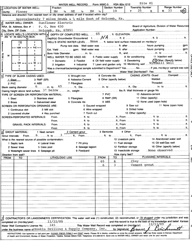
T25S, R33W, Sec. 19 NW NE NW |
Sunflower Electric Power Corp. | 65 ft. | Domestic, Livestock | Plugged | 22-Nov-1989 | Scan | |||
|
T25S, R33W, Sec. 20 SW SE SE SW |
Reeve Cattle Co. | 537 ft. | 297 ft. | 617 gpm. | Irrigation | Constructed | 16-Sep-2021 |
KOLAR |
|
|
T25S, R33W, Sec. 20 S2 NW NW |
Sunflower Electric Power | 460 ft. | 211 ft. | Monitoring well/observation/piezometer | Obs 4 | Constructed | 25-Mar-2005 | ||
|
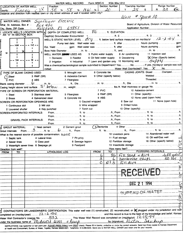
T25S, R33W, Sec. 20 SE SE NW |
Sunflower Electric Power Corp. | 86 ft. | Oil Field Water Supply | Spratt 10 | Plugged | 02-Dec-1994 | Scan | ||
|
T25S, R33W, Sec. 21 NW SW |
Circle Land and Cattle | 505 ft. | 280 ft. | 800 gpm. | Irrigation | Constructed | 10-Feb-2015 | ||
|
T25S, R33W, Sec. 21 SW SE NW NW |
Circle Land and Cattle | 540 ft. | 291 ft. | 1409 gpm. | Irrigation | Constructed | 04-Nov-2014 |
KOLAR |
|
|
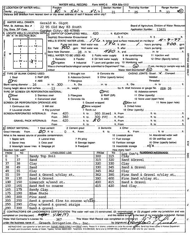
T25S, R33W, Sec. 21 NE SW SE |
Gigot, Gerald W. | 420 ft. | 176 ft. | 900 gpm. | Irrigation | Reconstructed | 07-Apr-1997 | Scan | |
|
T25S, R33W, Sec. 22 NE SW NW |
Reeve, M. P. | 450 ft. | 207 ft. | Irrigation | Constructed | 27-Feb-2008 | |||
|
T25S, R33W, Sec. 22 SE NW SE |
Reeve, M. P. | 460 ft. | 289 ft. | Irrigation | Constructed | 28-Jun-2011 | |||
|
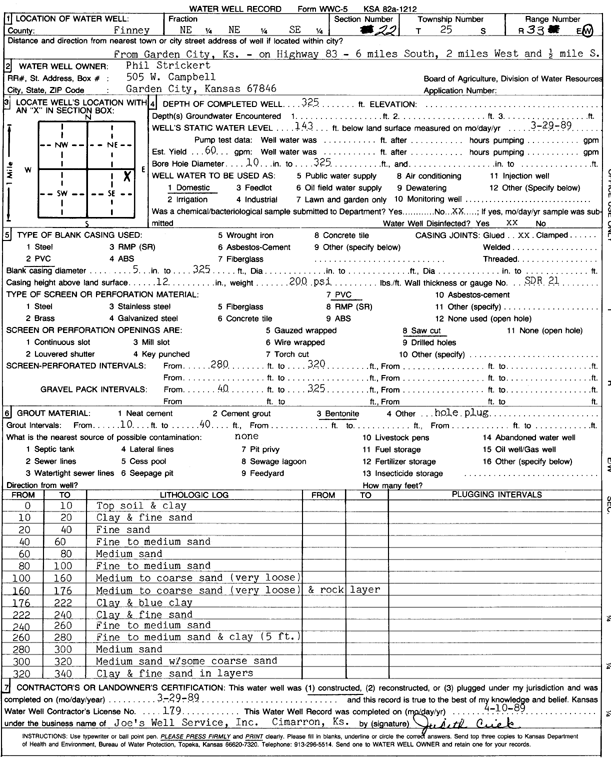
T25S, R33W, Sec. 22 NE NE SE |
Strickert, Phil | 325 ft. | 143 ft. | 60 gpm. | Domestic | Constructed | 29-Mar-1989 | Scan | |
|
T25S, R33W, Sec. 23 SE |
Gigot, Dean | 455 ft. | 124 ft. | 1750 gpm. | Irrigation | Constructed | 29-Dec-1980 | Scan | |
|
T25S, R33W, Sec. 23 NE |
Gigot, Dean | 470 ft. | 122 ft. | 1750 gpm. | Irrigation | Constructed | 31-Jan-1981 | Scan | |
|
T25S, R33W, Sec. 23 SW |
Gigot, Dean | 470 ft. | 139 ft. | 1740 gpm. | Irrigation | Constructed | 31-Jan-1981 | Scan | |
|
T25S, R33W, Sec. 23 NW |
Gigot, Dean | 475 ft. | 126 ft. | 1575 gpm. | Irrigation | Constructed | 31-Jan-1981 | Scan | |
|
T25S, R33W, Sec. 23 SE NW NE |
Trinity Feed Yard, Garden City | 438 ft. | 251 ft. | Feedlot | Plugged | 22-Feb-2016 | |||
|
T25S, R33W, Sec. 23 SE SE SE NE |
Trinity Feedyard | 518 ft. | 267 ft. | 1106 gpm. | Irrigation | Constructed | 12-Feb-2016 |
KOLAR |
|
|
T25S, R33W, Sec. 24 SE NE SE |
Aguilar, Jonathan | 560 ft. | 292 ft. | 50 gpm. | Domestic | Constructed | 28-Aug-2025 |
KOLAR |
|
|
T25S, R33W, Sec. 24 SW SW SW |
Garden City Feedyard | 171 ft. | 165 ft. | Feedlot | Plugged | 14-Sep-2015 | |||
|
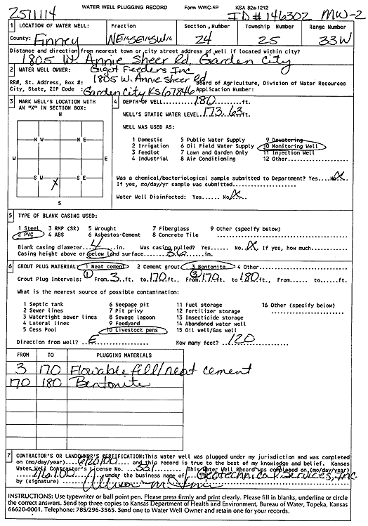
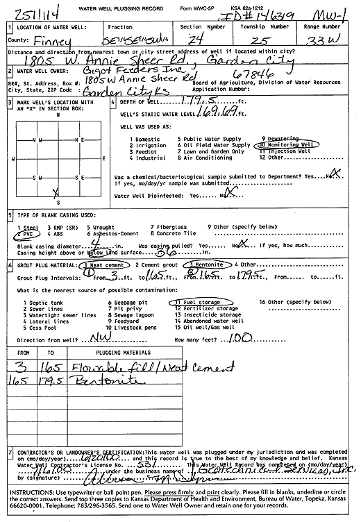
T25S, R33W, Sec. 24 NE SE SW |
Gigot Feeders Inc. | 180 ft. | 173.6 ft. | Monitoring well/observation/piezometer | MW 2 | Plugged | 20-Jun-2000 | Scan | |
|
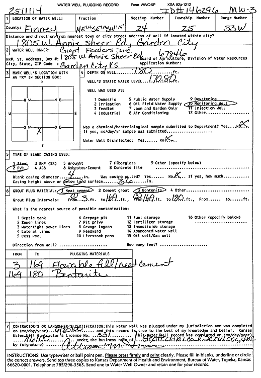
T25S, R33W, Sec. 24 NE SE SW |
Gigot Feeders Inc. | 180 ft. | 170.8 ft. | Monitoring well/observation/piezometer | MW 3 | Plugged | 20-Jun-2000 | Scan | |
|
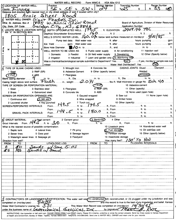
T25S, R33W, Sec. 24 SE SE SW |
Gigot Feeders Inc. | 179.5 ft. | 160.07 ft. | Monitoring well/observation/piezometer | Constructed | 21-Sep-1995 | Scan | ||
|
T25S, R33W, Sec. 24 SE SE SW |
Gigot Feeders Inc. | 179.5 ft. | 169.7 ft. | Monitoring well/observation/piezometer | MW 1 | Plugged | 20-Jun-2000 | Scan | |
|
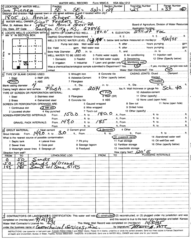
T25S, R33W, Sec. 24 SE SE SW |
Gigot Feeders Inc. | 180 ft. | 163.4 ft. | Monitoring well/observation/piezometer | Constructed | 21-Sep-1995 | Scan | ||
|
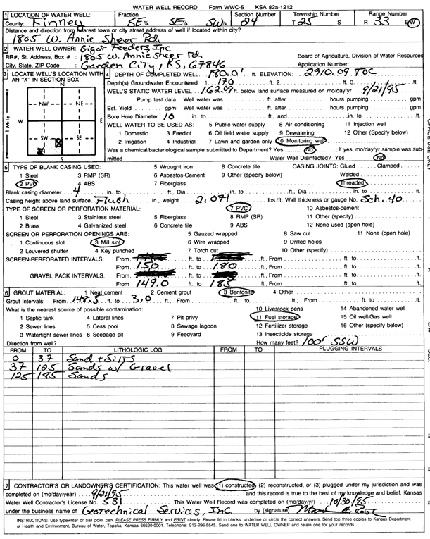
T25S, R33W, Sec. 24 SE SE SW |
Gigot Feeders Inc. | 180 ft. | 162.09 ft. | Monitoring well/observation/piezometer | Constructed | 21-Sep-1995 | Scan | ||
|
T25S, R33W, Sec. 24 NE SE SE |
Leal, Faylene | 508 ft. | 282 ft. | 50 gpm. | Domestic | Constructed | 30-Apr-2025 |
KOLAR |
|
|
T25S, R33W, Sec. 24 SE SW NE SE |
Moore, Tammy | 400 ft. | 210 ft. | 75 gpm. | Domestic | Constructed | 28-Jan-2013 | ||
|
T25S, R33W, Sec. 24 SW NW NE |
Reeve Cattle Co. | 532 ft. | 268 ft. | 1400 gpm. | Irrigation | Constructed | 09-Apr-2024 |
KOLAR |
|
|
T25S, R33W, Sec. 24 SE NE SE |
Rios, Ignacio | 560 ft. | 304 ft. | 50 gpm. | Domestic | Constructed | 17-Sep-2025 |
KOLAR |
|
|
T25S, R33W, Sec. 24 NW SE SW |
Rocking T Ranch LLC | 560 ft. | 284 ft. | Feedlot | Constructed | 20-May-2022 |
KOLAR |
||
|
T25S, R33W, Sec. 24 SW SE |
Southwest Corn | 293 ft. | 145 ft. | Domestic | Constructed | 02-Jun-1987 | Scan | ||
|
T25S, R33W, Sec. 25 NE NE |
Dew, Preston | 339 ft. | 150 ft. | Domestic | Constructed | 30-Jul-1988 | Scan | ||
|
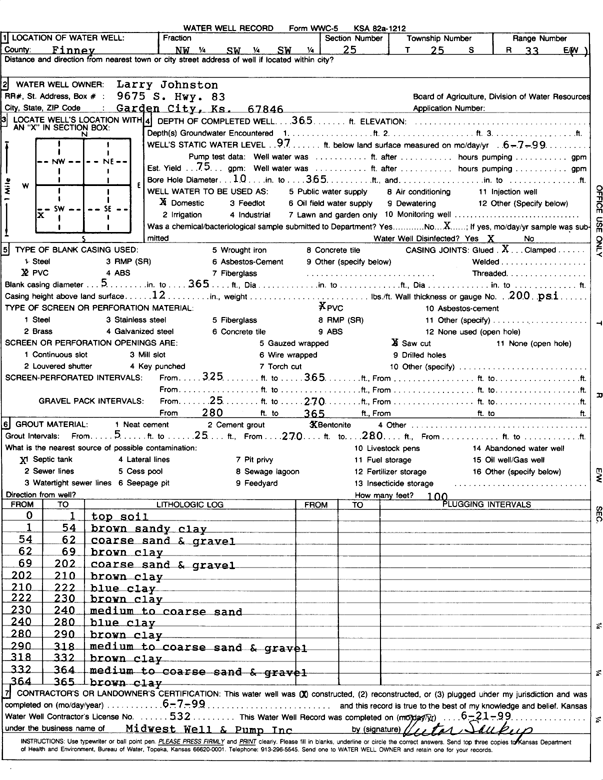
T25S, R33W, Sec. 25 NW SW SW |
Johnston, Larry | 365 ft. | 97 ft. | 75 gpm. | Domestic | Constructed | 07-Jun-1999 | Scan | |
|
T25S, R33W, Sec. 25 SE NE SW |
Larry Johnston Trust and Esther Johnston Trust | 440 ft. | 172 ft. | Irrigation | Constructed | 07-Feb-1998 | Scan | ||
|
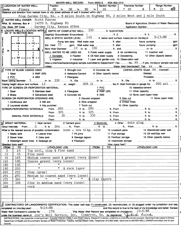
T25S, R33W, Sec. 26 SE SE NE |
Duncan, Scott | 330 ft. | 149 ft. | 75 gpm. | Domestic | Constructed | 14-Sep-1988 | Scan | |
|
T25S, R33W, Sec. 26 NW SE SE |
Glaves, S.J. and Connie | 419 ft. | 181 ft. | Irrigation | Constructed | 18-Dec-2002 | Scan | ||
|
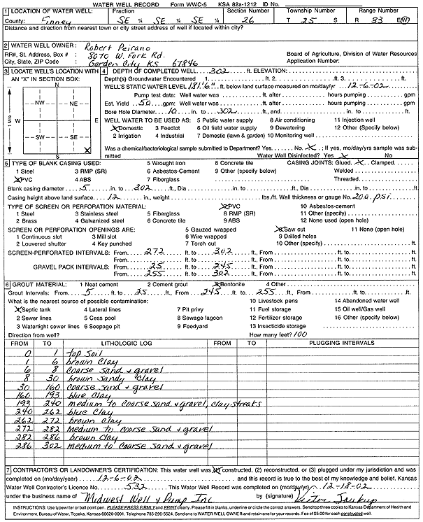
T25S, R33W, Sec. 26 SE SE SE |
Peirano, Robert | 302 ft. | 181.6 ft. | 50 gpm. | Domestic | Constructed | 06-Dec-2002 | Scan | |
|
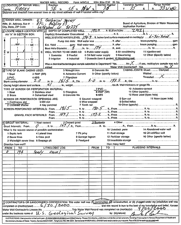
T25S, R33W, Sec. 26 SE SE NW |
U.S. Geological Survey | 193.2 ft. | 174.9 ft. | Monitoring well/observation/piezometer | Constructed | 30-Jun-2000 | Scan | ||
| View page: < Prev || 91 || 92 || 93 || 94 || 95 || 96 || 97 || 98 || 99 || 100 || Next > | |||||||||