Select location of well to view details.
Click on column heading to sort.
|
|
|
County: Franklin Select location of well to view details. Click on column heading to sort. |
|
|
|
| View page: < Prev || 11 || 12 || 13 || 14 || 15 || 16 || 17 || 18 || 19 || 20 || Next > | |||||||||
| T-R-S | Owner | Well Depth Ascend. Desc. |
Static Water Level Ascend. Desc. |
Est. Yield Ascend. Desc. |
Well Use | Other ID | Action Taken | Completion Date Ascend. Desc. |
Scan? |
|
T16S, R19E, Sec. 36 NW NW NW |
KDHE (Baxter Oil) | 20 ft. | 5.42 ft. | Monitoring well/observation/piezometer | MW 2 | Constructed | 25-Jan-2010 | ||
|
T16S, R19E, Sec. 36 NW NW NW |
KDHE (Baxter Oil) | 18 ft. | 4.49 ft. | Monitoring well/observation/piezometer | MW 6 | Constructed | 26-Jan-2010 | ||
|
T16S, R19E, Sec. 36 NW NW NW |
KDHE (Baxter Oil) | 16.7 ft. | 12.02 ft. | Monitoring well/observation/piezometer | MW 11 | Constructed | 19-Jul-2010 | ||
|
T16S, R19E, Sec. 36 NW NW NW |
KDHE (Baxter Oil) | 16 ft. | 5.98 ft. | Monitoring well/observation/piezometer | MW 5 | Constructed | 26-Jan-2010 | ||
|
T16S, R19E, Sec. 36 NW NW NW |
KDHE (Baxter Oil) | 18 ft. | 4.06 ft. | Monitoring well/observation/piezometer | MW 9 | Constructed | 26-Jan-2010 | ||
|
T16S, R19E, Sec. 36 NW NW NW |
KDHE (Baxter Oil) | 18 ft. | 14.22 ft. | Monitoring well/observation/piezometer | MW 10 | Constructed | 19-Jul-2010 | ||
|
T16S, R19E, Sec. 36 NW NW NW |
KDHE (Baxter Oil) | 18 ft. | 5.66 ft. | Monitoring well/observation/piezometer | MW 4 | Constructed | 25-Jan-2010 | ||
|
T16S, R19E, Sec. 36 NW NW NW |
KDHE (Baxter Oil) | 20 ft. | 5.45 ft. | Monitoring well/observation/piezometer | MW 3 | Constructed | 25-Jan-2010 | ||
|
T16S, R19E, Sec. 36 NW NW NW |
KDHE (Baxter Oil) | 18 ft. | 5.31 ft. | Monitoring well/observation/piezometer | MW 7 | Constructed | 26-Jan-2010 | ||
|
T16S, R19E, Sec. 36 SW SW NW NW |
KDHE (Jim Bass Electric) | 25 ft. | 10.07 ft. | Monitoring well/observation/piezometer | MW 10 | Constructed | 20-Jun-2022 | ||
|
T16S, R19E, Sec. 36 NW SE SW NW |
KDHE BER | 25 ft. | 20.13 ft. | Monitoring well/observation/piezometer | MW 4 | Constructed | 22-Dec-2020 |
KOLAR |
|
|
T16S, R19E, Sec. 36 SW NE SW NW |
KDHE BER | 21 ft. | 16.45 ft. | Monitoring well/observation/piezometer | MW 3 | Constructed | 21-Dec-2020 |
KOLAR |
|
|
T16S, R19E, Sec. 36 NE SE SW NW |
KDHE BER | 25 ft. | 18.68 ft. | Monitoring well/observation/piezometer | MW 2 | Constructed | 22-Dec-2020 |
KOLAR |
|
|
T16S, R19E, Sec. 36 SE NE SW NW |
KDHE BER | 20 ft. | 16.08 ft. | Monitoring well/observation/piezometer | MW 1 | Constructed | 21-Dec-2020 |
KOLAR |
|
|
T16S, R19E, Sec. 36 E2 NE NW SW |
KDHE BER | 19.5 ft. | 16.16 ft. | Monitoring well/observation/piezometer | MW 5 | Constructed | 21-Dec-2020 |
KOLAR |
|
|
T16S, R19E, Sec. 36 SW NW SE NW |
KDHE BER | 19 ft. | 16.08 ft. | Monitoring well/observation/piezometer | MW 6 | Constructed | 22-Dec-2020 |
KOLAR |
|
|
T16S, R19E, Sec. 36 SE NE SW |
Schuls, Jamie | 20 ft. | Domestic | Plugged | 13-Feb-2006 | ||||
|
T16S, R20E, Sec. 1 NW NW SW |
Hull, Eddie | 90 ft. | Domestic | Constructed | 23-Feb-1963 | ||||
|
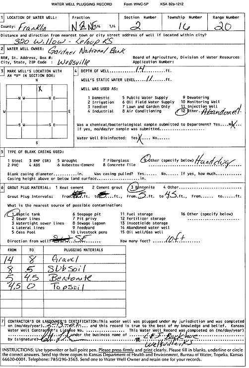
T16S, R20E, Sec. 2 N2 NE |
Gardner National Bank | 14 ft. | 11 ft. | (unstated)/abandoned | Plugged | 13-Feb-2002 | Scan | ||
|
T16S, R20E, Sec. 4 SW NW |
Hayes Township | 15 ft. | 10 ft. | Domestic | Plugged | 02-Nov-2011 | |||
|
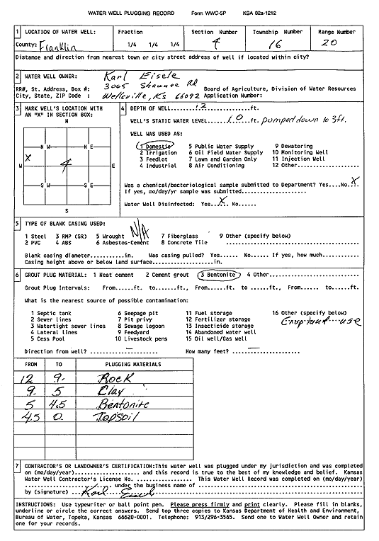
T16S, R20E, Sec. 4 SW SW NW |
Karl Eisele | 12 ft. | 10 ft. | Domestic | Plugged | 01-Apr-2001 | Scan | ||
|
T16S, R20E, Sec. 15 NW NE |
Wood, H. R. | 50 ft. | Domestic | Constructed | 06-May-1950 | ||||
|
T16S, R20E, Sec. 18 S2 SE |
Kansas Dept. of Transportation, KDOT | 58 ft. | Test Hole, Geotechnical | 59-30 K-7889-01 | Constructed | 07-Jun-2004 | |||
|
T16S, R20E, Sec. 18 S2 SE |
Kansas Dept. of Transportation, KDOT | 43 ft. | Test Hole, Geotechnical | 59-30 K-7889-01 | Constructed | 07-Jun-2004 | |||
|
T16S, R20E, Sec. 19 SW SW SW |
Our Own Hardware Co | 13 ft. | 1.9 ft. | Monitoring well/observation/piezometer | MW 3 | Constructed | 10-Apr-1997 | ||
|
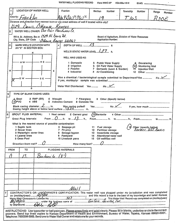
T16S, R20E, Sec. 19 NW SW SW |
Our Own Hardware Co | 13 ft. | 1.27 ft. | Monitoring well/observation/piezometer | MW 1 | Constructed | 10-Apr-1997 | ||
|
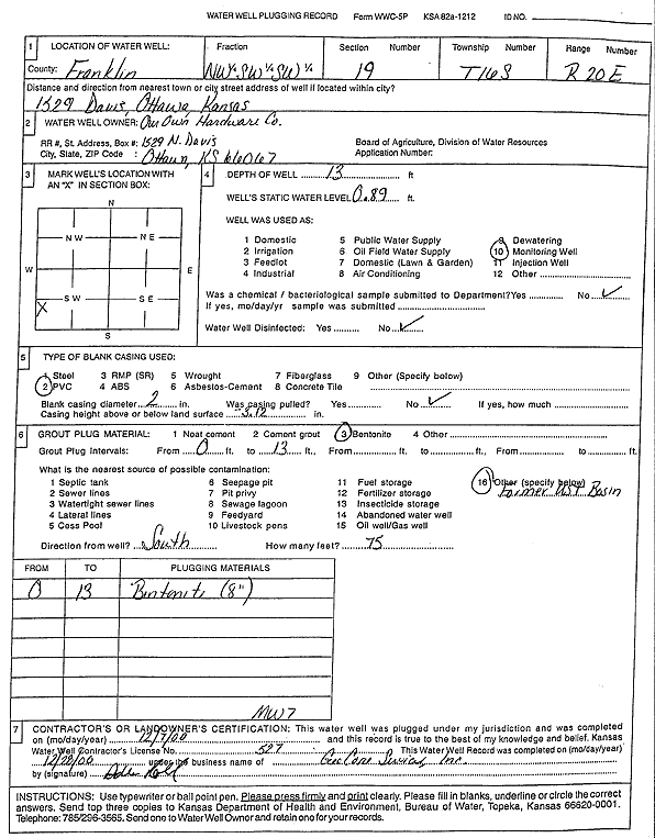
T16S, R20E, Sec. 19 NW SW SW |
Our Own Hardware Co | 13 ft. | .89 ft. | Monitoring well/observation/piezometer | MW 7 | Constructed | 17-Jun-1997 | ||
|
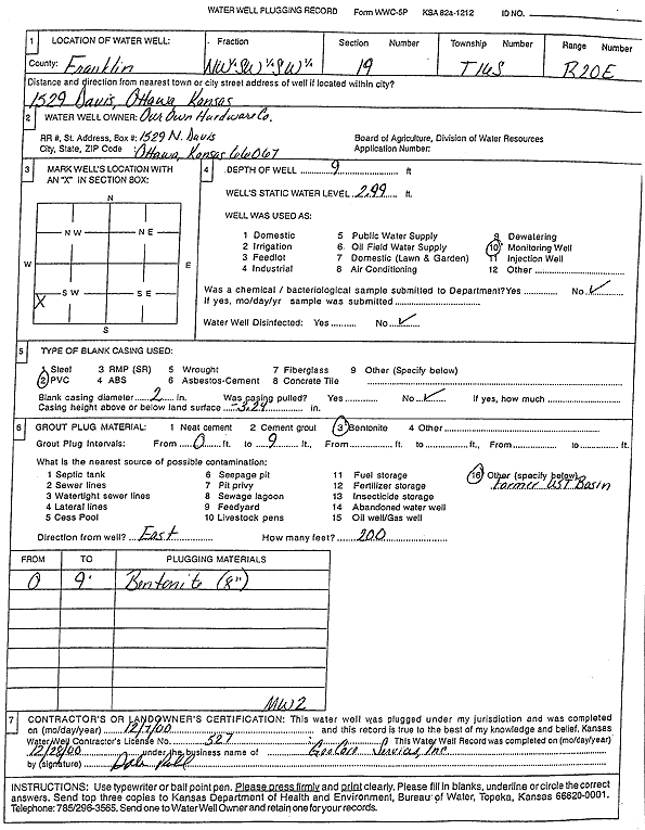
T16S, R20E, Sec. 19 NW SW SW |
Our Own Hardware Co | 9 ft. | 2.99 ft. | Monitoring well/observation/piezometer | MW 2 | Constructed | 10-Apr-1997 | ||
|
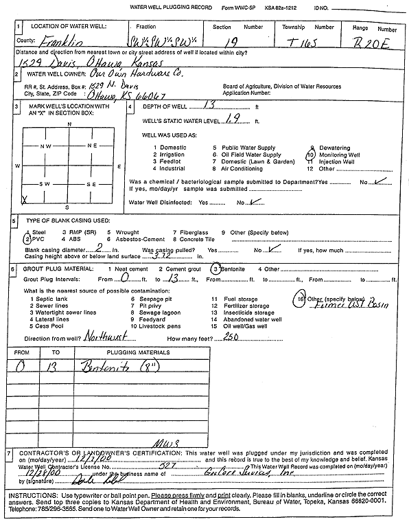
T16S, R20E, Sec. 19 NW SW SW |
Our Own Hardware Co. | 13 ft. | .89 ft. | Monitoring well/observation/piezometer | Plugged | 07-Dec-2000 | Scan | ||
|
T16S, R20E, Sec. 19 NW SW SW |
Our Own Hardware Co. | 13 ft. | 1.27 ft. | Monitoring well/observation/piezometer | Plugged | 07-Dec-2000 | Scan | ||
|
T16S, R20E, Sec. 19 SW SW SW |
Our Own Hardware Co. | 13 ft. | 1.9 ft. | Monitoring well/observation/piezometer | Plugged | 07-Dec-2000 | Scan | ||
|
T16S, R20E, Sec. 19 NW SW SW |
Our Own Hardware Co. | 9 ft. | 2.99 ft. | Monitoring well/observation/piezometer | Plugged | 07-Dec-2000 | Scan | ||
|
T16S, R20E, Sec. 19 NW SE NW |
Rumford, Raymond | 120 ft. | Heat Pump (Closed Loop/Disposal), Geothermal | Constructed | 24-May-1996 | ||||
|
T16S, R20E, Sec. 19 NW NW NW |
Rumford, Raymond | 62 ft. | 25 ft. | Domestic | Plugged | 21-Aug-1992 | |||
|
T16S, R20E, Sec. 19 SW SW NW |
Rumford, Raymond | 58 ft. | 10 ft. | 12 gpm. | Domestic | Constructed | 21-Aug-1992 | ||
|
T16S, R20E, Sec. 19 SW SW NW |
Rumford, Raymond | 150 ft. | 98.5 ft. | .2 gpm. | Feedlot | Reconstructed | 09-Apr-1998 | ||
|
T16S, R20E, Sec. 19 NW NW SW |
Rumford, Raymond | 140 ft. | 13 ft. | Feedlot | Constructed | 24-Jan-1994 | |||
|
T16S, R20E, Sec. 20 NE NE NE SE |
Haney, Cadence | 21 ft. | 6 ft. | Domestic | Plugged | 07-Sep-2017 | |||
|
T16S, R20E, Sec. 20 SE SW |
Kansas Dept. of Transportation, KDOT | 57.5 ft. | Test Hole, Geotechnical | 59-30 K-7889-01 | Constructed | 02-Jun-2004 | |||
|
T16S, R20E, Sec. 20 E2 SE |
Kansas Dept. of Transportation, KDOT | 53 ft. | Test Hole, Geotechnical | 59-30 K-7889-01 | Constructed | 18-May-2005 | |||
|
T16S, R20E, Sec. 20 SE SW |
Kansas Dept. of Transportation, KDOT | 63.5 ft. | Test Hole, Geotechnical | 59-30 K-7889-01 | Constructed | 07-Jun-2004 | |||
|
T16S, R20E, Sec. 21 SE SE SE |
State of Kansas DOT | 18 ft. | 8 ft. | Other | Plugged | 18-Sep-2008 | |||
|
T16S, R20E, Sec. 22 NW SW SW |
Barnes, Clayton | 100 ft. | 60 ft. | 1 gpm. | Domestic | Constructed | 27-Mar-1998 | ||
|
T16S, R20E, Sec. 23 SE |
Penny Concrete Inc. | 17 ft. | 12 ft. | Domestic | Plugged | 21-Mar-2005 | |||
|
T16S, R20E, Sec. 24 SW NW NE |
Van Horn, Gene | 18 ft. | 13 ft. | (unstated)/abandoned | Plugged | 15-Apr-1996 | |||
|
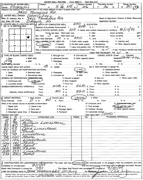
T16S, R20E, Sec. 26 S2 NE |
Gillogly, Dave | 250 ft. | 100 ft. | 3 gpm. | Domestic | Constructed | 17-Aug-1999 | Scan | |
|
T16S, R20E, Sec. 26 S2 NE |
Gillogly, Dave | 250 ft. | 100 ft. | 3 gpm. | Domestic | Constructed | 16-Aug-1999 | Scan | |
|
T16S, R20E, Sec. 27 NE NE SE |
Kile, Bob | 100 ft. | Domestic | Plugged | 20-Dec-1975 | ||||
|
T16S, R20E, Sec. 27 SW SW SE |
Piere, Charles | 40 ft. | Domestic | Plugged | 01-Oct-1976 | ||||
|
T16S, R20E, Sec. 28 SE SW NW |
Franklin County | 40 ft. | 22.36 ft. | Monitoring well/observation/piezometer | MW 14 | Constructed | 16-Feb-2022 |
KOLAR |
|
| View page: < Prev || 11 || 12 || 13 || 14 || 15 || 16 || 17 || 18 || 19 || 20 || Next > | |||||||||