Select location of well to view details.
Click on column heading to sort.
|
|
|
County: Franklin Select location of well to view details. Click on column heading to sort. |
|
|
|
| View page: < Prev || 11 || 12 || 13 || 14 || 15 || 16 || 17 || 18 || 19 || 20 || Next > | |||||||||
| T-R-S | Owner | Well Depth Ascend. Desc. |
Static Water Level Ascend. Desc. |
Est. Yield Ascend. Desc. |
Well Use | Other ID | Action Taken | Completion Date Ascend. Desc. |
Scan? |
|
T17S, R18E, Sec. 7 NW NE SE |
Van Horn, Harold | 30 ft. | 10 ft. | Domestic, Livestock | Plugged | 28-May-1994 | |||
|
T17S, R18E, Sec. 8 SW SW SW |
Combs, Doug | 140 ft. | 75 ft. | 7 gpm. | Domestic | Constructed | 28-Mar-1978 | ||
|
T17S, R18E, Sec. 8 SW SW SW |
Hoch, Don | 180 ft. | 12.3 ft. | 20 gpm. | Domestic | Constructed | 17-Sep-2010 | ||
|
T17S, R18E, Sec. 8 SW SW SW |
Hock, Dick | 150 ft. | 80 ft. | 7 gpm. | Domestic | Constructed | 01-Nov-1977 | ||
|
T17S, R18E, Sec. 9 SE SW NE |
Fish, George | 70 ft. | 35 ft. | 20 gpm. | Domestic | Constructed | 24-Apr-1987 | ||
|
T17S, R18E, Sec. 9 SW SW SE |
Foster, James | 180 ft. | 64 ft. | 60 gpm. | Domestic | Constructed | 16-Jun-1993 | ||
|
T17S, R18E, Sec. 9 SE SE NE SE |
Franklin Co. RWD 4 | 162 ft. | 23 ft. | Public Water Supply | Plugged | 12-Sep-2019 | |||
|
T17S, R18E, Sec. 9 SE SE NE SE |
Franklin Co. RWD 4 | 173 ft. | 31 ft. | Public Water Supply | Plugged | 12-Sep-2019 | |||
|
T17S, R18E, Sec. 9 SE SE NE SE |
Franklin Co. RWD 4 | 165 ft. | 24 ft. | Public Water Supply | Plugged | 12-Sep-2019 | |||
|
T17S, R18E, Sec. 9 SE SE NE SE |
Franklin Co. RWD 4 | 160 ft. | 25 ft. | 100 gpm. | Public Water Supply | 9 | Constructed | 20-Sep-2018 |
KOLAR |
|
T17S, R18E, Sec. 9 NW NW SE |
Griffin, Thelmo | 90 ft. | 30 ft. | 24 gpm. | Domestic | Constructed | 02-Oct-1988 | ||
|
T17S, R18E, Sec. 9 SW SE SE |
Shepard, C. J. | 85 ft. | 25 ft. | 2 gpm. | Domestic | Constructed | 10-Feb-1997 | ||
|
T17S, R18E, Sec. 9 SWSESE |
Shepheard, C. J. | 75 ft. | 35 ft. | Domestic | Plugged | 17-Feb-1997 | |||
|
T17S, R18E, Sec. 9 SW SW NE |
Stevenson, Alfred | 100 ft. | 20 ft. | 40 gpm. | Domestic | Constructed | 06-Jul-1976 | ||
|
T17S, R18E, Sec. 10 SW SW SE |
Flager, Orval | 115 ft. | 40 ft. | 15 gpm. | Domestic | Constructed | 18-Oct-1978 | ||
|
T17S, R18E, Sec. 10 NW NW SW |
Reed, Joe | 90 ft. | 22 ft. | 13 gpm. | Domestic | Constructed | 01-Dec-1980 | ||
|
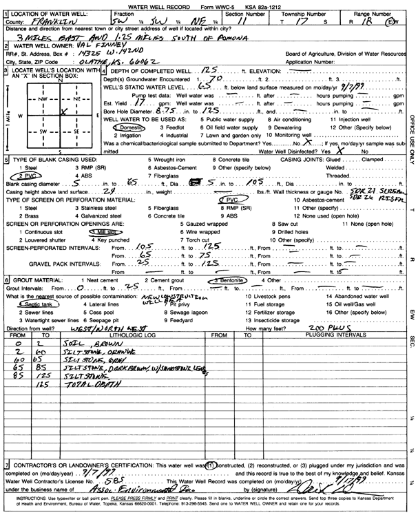
T17S, R18E, Sec. 11 SW SW NE |
Finney, Val | 125 ft. | 65 ft. | 17 gpm. | Domestic | Constructed | 07-Sep-1999 | Scan | |
|
T17S, R18E, Sec. 11 SE SE SW |
Franklin Co RWD 4 | 259 ft. | 125 ft. | Public Water Supply | Plugged | 23-Apr-1987 | |||
|
T17S, R18E, Sec. 11 NE SE SW |
Franklin Co RWD 4 | 261 ft. | 125 ft. | Public Water Supply | Plugged | 23-Apr-1987 | |||
|
T17S, R18E, Sec. 11 NE SE SW |
Franklin Co RWD 4 | 231 ft. | 105 ft. | Public Water Supply | Plugged | 23-Apr-1987 | |||
|
T17S, R18E, Sec. 11 SE SE SW |
Franklin Co RWD 4 | 258 ft. | 122 ft. | Public Water Supply | Plugged | 23-Apr-1987 | |||
|
T17S, R18E, Sec. 11 SW NW NE SE |
Franklin County | 23.6 ft. | Monitoring well/observation/piezometer | MW 12 | Constructed | 18-Nov-2019 | |||
|
T17S, R18E, Sec. 11 SW NW NE SE |
Franklin County | 23.77 ft. | Monitoring well/observation/piezometer | MW 11 | Constructed | 18-Nov-2019 | |||
|
T17S, R18E, Sec. 11 SW NW NE SE |
Franklin County | 23.48 ft. | Monitoring well/observation/piezometer | MW 1 | Constructed | 18-Nov-2019 | |||
|
T17S, R18E, Sec. 11 SW NW NE SE |
Franklin County | 21.35 ft. | Monitoring well/observation/piezometer | MW 2 | Constructed | 18-Nov-2019 | |||
|
T17S, R18E, Sec. 11 NW NW NE SE |
Franklin County | 24.18 ft. | Monitoring well/observation/piezometer | MW 3 | Constructed | 15-Nov-2019 | |||
|
T17S, R18E, Sec. 11 NW NW NE SE |
Franklin County | 24.17 ft. | Monitoring well/observation/piezometer | MW 10 | Constructed | 15-Nov-2019 | |||
|
T17S, R18E, Sec. 11 SW NW NE SE |
Franklin County | 26.97 ft. | Monitoring well/observation/piezometer | MW 5 | Constructed | 18-Nov-2019 | |||
|
T17S, R18E, Sec. 11 SW NW NE SE |
Franklin County | 23.97 ft. | Monitoring well/observation/piezometer | MW 6 | Constructed | 15-Nov-2019 | |||
|
T17S, R18E, Sec. 11 SW NW NE SE |
Franklin County | 21.12 ft. | Monitoring well/observation/piezometer | MW 7 | Constructed | 14-Nov-2019 | |||
|
T17S, R18E, Sec. 11 SW NW NE SE |
Franklin County | 24.68 ft. | Monitoring well/observation/piezometer | MW 8 | Constructed | 14-Nov-2019 | |||
|
T17S, R18E, Sec. 11 SW NW NE SE |
Franklin County | 19.43 ft. | Monitoring well/observation/piezometer | MW 9 | Constructed | 14-Nov-2019 | |||
|
T17S, R18E, Sec. 11 NW NW NE SE |
Franklin County | 24.17 ft. | Monitoring well/observation/piezometer | MW 4 | Constructed | 15-Nov-2019 | |||
|
T17S, R18E, Sec. 11 NW SW NE |
Leach, Rob | 144 ft. | 25 ft. | 18 gpm. | Domestic | Constructed | 16-Aug-1979 | ||
|
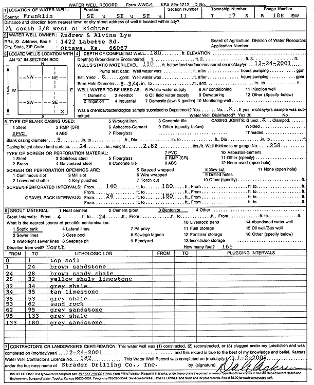
T17S, R18E, Sec. 11 SE SE SE |
Lye, Andrew and Alvina | 180 ft. | 110 ft. | 8 gpm. | Domestic | Constructed | 24-Dec-2001 | Scan | |
|
T17S, R18E, Sec. 11 NE NE NE |
Mark, Eugene H | 110 ft. | 51 ft. | 12 gpm. | Domestic | Constructed | 06-Nov-1978 | ||
|
T17S, R18E, Sec. 11 NE SE SE |
Pruett, Jim | 150 ft. | 25 ft. | 5 gpm. | Domestic | Constructed | 15-May-1993 | ||
|
T17S, R18E, Sec. 11 SW SW SE |
Reinke, Fred J | 150 ft. | 42 gpm. | (unstated)/abandoned | Constructed | 03-Jun-1961 | |||
|
T17S, R18E, Sec. 11 SE SE SE |
Weiderholt, Ralph | 95 ft. | 25 ft. | 2 gpm. | Domestic | Constructed | 03-Nov-1978 | ||
|
T17S, R18E, Sec. 12 NW NE SW |
Buehler, David | 14 ft. | 52 ft. | 6 gpm. | Domestic | Constructed | 08-Apr-1996 | ||
|
T17S, R18E, Sec. 12 SE SE SE |
Gillen, Jim | 100 ft. | 29 ft. | 5 gpm. | Domestic | Constructed | 14-Jul-2010 | ||
|
T17S, R18E, Sec. 12 NE SE SE |
Gilliland, Jim | 100 ft. | 56 ft. | 1 gpm. | Domestic | Constructed | 17-Feb-1995 | ||
|
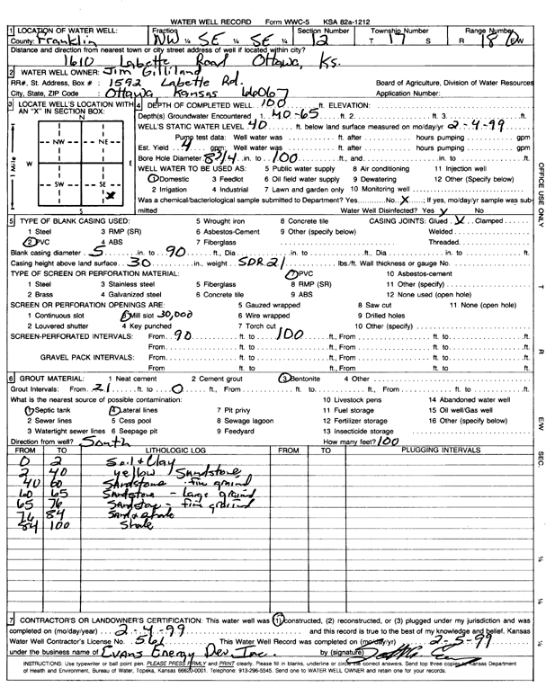
T17S, R18E, Sec. 12 NW SE SE |
Gilliland, Jim | 100 ft. | 40 ft. | 4 gpm. | Domestic | Constructed | 04-Feb-1999 | Scan | |
|
T17S, R18E, Sec. 12 NW SE SE |
Gilliland, Jim | 68 ft. | 55 ft. | 3 gpm. | Domestic | Constructed | 17-Feb-1995 | ||
|
T17S, R18E, Sec. 12 NW SE SE |
Gilliland, Jim | 88 ft. | 53 ft. | 1 gpm. | Domestic | Constructed | 17-Feb-1995 | ||
|
T17S, R18E, Sec. 12 NE SE |
Gorton, W. J. | 31.5 ft. | (unstated)/abandoned | Constructed | 03-May-1950 | ||||
|
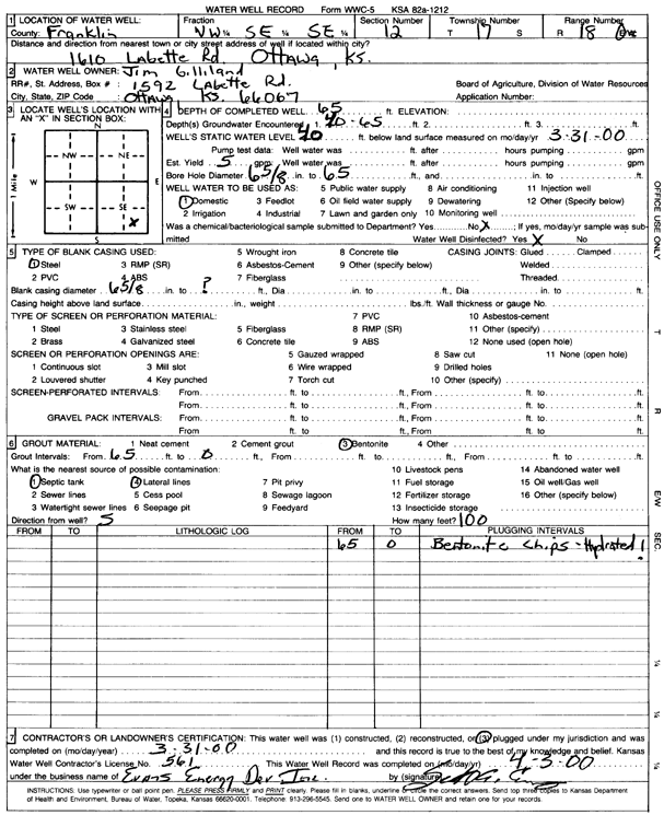
T17S, R18E, Sec. 12 NW SE SE |
Jim Gilland | 65 ft. | 40 ft. | Domestic | Plugged | 31-Mar-2000 | Scan | ||
|
T17S, R18E, Sec. 12 NE NW SE |
Peffly, Jonathan | 110 ft. | 20 ft. | 1 gpm. | Domestic | Constructed | 16-May-1978 | ||
|
T17S, R18E, Sec. 12 NE SE SE |
Wright, Steve | 90 ft. | 50 ft. | Domestic | Plugged | 06-Mar-2008 | |||
|
T17S, R18E, Sec. 12 NE SE SE |
Wright, Steve | 140 ft. | 39 ft. | 1 gpm. | Domestic | Constructed | 19-Nov-2007 | ||
| View page: < Prev || 11 || 12 || 13 || 14 || 15 || 16 || 17 || 18 || 19 || 20 || Next > | |||||||||