Select location of well to view details.
Click on column heading to sort.
|
|
|
County: Grant Select location of well to view details. Click on column heading to sort. |
|
|
|
| View page: < Prev || 11 || 12 || 13 || 14 || 15 || 16 || 17 || 18 || 19 || 20 || Next > | |||||||||
| T-R-S | Owner | Well Depth Ascend. Desc. |
Static Water Level Ascend. Desc. |
Est. Yield Ascend. Desc. |
Well Use | Other ID | Action Taken | Completion Date Ascend. Desc. |
Scan? |
|
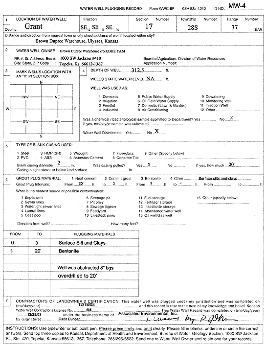
T28S, R37W, Sec. 17 SE SE SE |
Brown Dupree Warehouse | 312.5 ft. | Monitoring well/observation/piezometer | MW 4 | Plugged | 18-Dec-2003 | Scan | ||
|
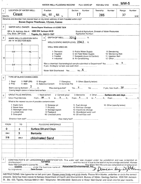
T28S, R37W, Sec. 17 SE SE SE |
Brown Dupree Warehouse | 321 ft. | 234.2 ft. | Monitoring well/observation/piezometer | MW 5 | Plugged | 18-Dec-2003 | Scan | |
|
T28S, R37W, Sec. 17 SE SE SE |
Dupree, Harold | 387 ft. | 220 ft. | Domestic | Constructed | 05-Nov-1982 | |||
|
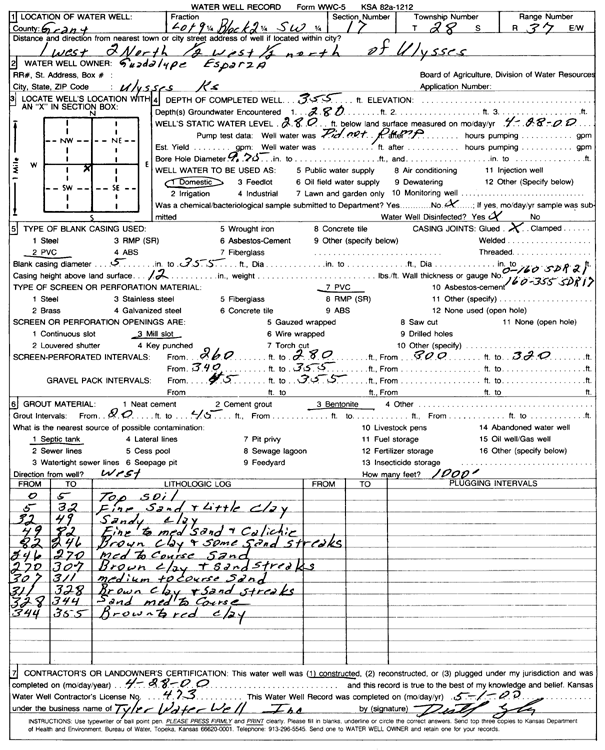
T28S, R37W, Sec. 17 SW |
Esparza, Guadalupe | 355 ft. | 280 ft. | Domestic | Constructed | 28-Apr-2000 | Scan | ||
|
T28S, R37W, Sec. 17 SW SW SW |
Hall, Calvin | 403 ft. | 240 ft. | 30 gpm. | Domestic | Constructed | 10-Sep-1980 | ||
|
T28S, R37W, Sec. 17 SE SW SW |
Hampton, Lloyd | 400 ft. | 167 ft. | 30 gpm. | Domestic | Constructed | 30-Apr-1979 | ||
|
T28S, R37W, Sec. 17 NW NW SW |
Koehn, Marcus | 376 ft. | 235 ft. | 30 gpm. | Domestic | Constructed | 22-Apr-1989 | ||
|
T28S, R37W, Sec. 17 SW SW SW |
Kreger, Bill | 403 ft. | 240 ft. | 25 gpm. | Domestic | Constructed | 30-Sep-1980 | ||
|
T28S, R37W, Sec. 17 SW SW SW |
Leiker, Gilbert | 400 ft. | 167 ft. | 30 gpm. | Feedlot | Constructed | 19-Jun-1979 | ||
|
T28S, R37W, Sec. 17 SW SW SW |
Leiker, Gilbert | 407 ft. | 167 ft. | 30 gpm. | Domestic | Constructed | 20-Jun-1979 | ||
|
T28S, R37W, Sec. 17 C E2 SE |
Minter-Wilson Drilling | 380 ft. | 240 ft. | 75 gpm. | Domestic | Constructed | 22-Sep-1994 | ||
|
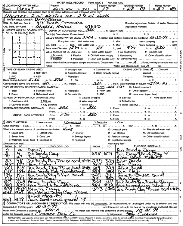
T28S, R37W, Sec. 17 NW NW SW |
Orosco, Danny | 380 ft. | 240 ft. | Domestic | Constructed | 25-Oct-1999 | Scan | ||
|
T28S, R37W, Sec. 17 SE SE SW |
Rogers, Bill | 395 ft. | 240 ft. | 35 gpm. | Pond/Swimming Pool/Recreation | Constructed | 30-Sep-1979 | ||
|
T28S, R37W, Sec. 17 SW SW SW |
Rogers, Bill | 405 ft. | 350 ft. | Domestic | Constructed | 27-Aug-1988 | |||
|
T28S, R37W, Sec. 17 SE SE SE |
Rogers, Bill | 400 ft. | 243 ft. | 30 gpm. | Domestic | Constructed | 02-May-1978 | ||
|
T28S, R37W, Sec. 17 SE SE SW |
Rogers, Bill | 400 ft. | 240 ft. | 35 gpm. | Pond/Swimming Pool/Recreation | Constructed | 30-Sep-1979 | ||
|
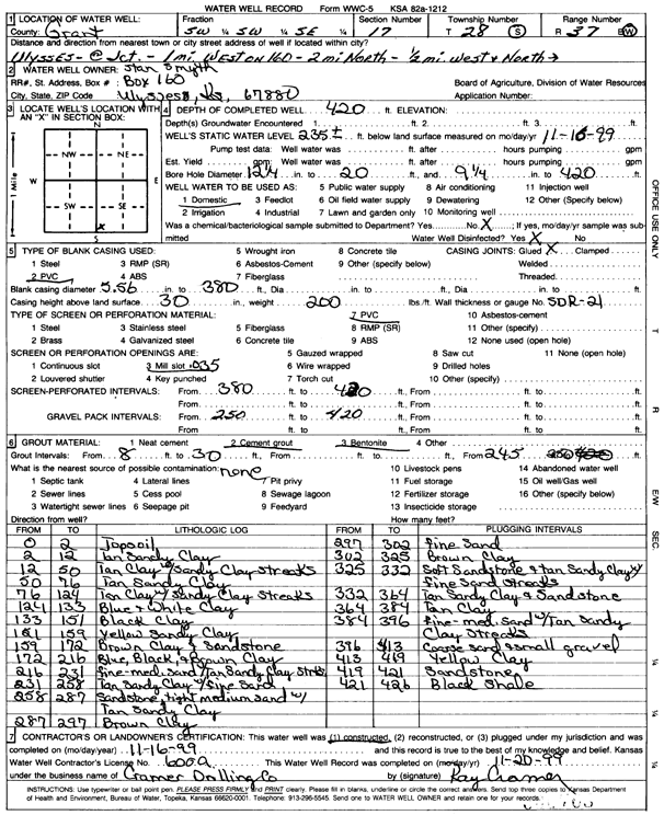
T28S, R37W, Sec. 17 SW SW SE |
Smyth, Stan | 420 ft. | 235 ft. | Domestic | Constructed | 16-Nov-1999 | Scan | ||
|
T28S, R37W, Sec. 17 SE SE NE |
Sullivan, Dale | 560 ft. | 167 ft. | 1400 gpm. | Irrigation | Constructed | 28-Feb-1979 | ||
|
T28S, R37W, Sec. 17 NW SW SE |
SW Windmill | 360 ft. | 190 ft. | Domestic | Constructed | 15-Oct-2010 | |||
|
T28S, R37W, Sec. 17 SW |
Wells, Garold | 400 ft. | Domestic | Constructed | 27-Mar-2008 | ||||
|
T28S, R37W, Sec. 17 SE NE SW |
Wilkie, Brat | 410 ft. | 240 ft. | 55 gpm. | Domestic | Constructed | 16-May-1996 | ||
|
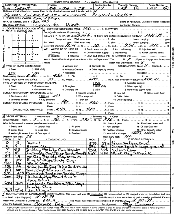
T28S, R37W, Sec. 17 SE SW SE |
Wilson, Jim | 410 ft. | 235 ft. | Domestic | Constructed | 18-Nov-1999 | Scan | ||
|
T28S, R37W, Sec. 18 SE NW SW |
Vermes, Marcella L. | 255 ft. | Domestic | Plugged | 20-Feb-2001 | Scan | |||
|
T28S, R37W, Sec. 20 SE NE NW |
Chase, Jay | 405 ft. | 170 ft. | 60 gpm. | Domestic | Constructed | 20-Feb-1987 | ||
|
T28S, R37W, Sec. 20 SW SE NE NW |
Chase, Jay | 420 ft. | 195 ft. | 15 gpm. | Domestic | Constructed | 07-Oct-2014 |
KOLAR |
|
|
T28S, R37W, Sec. 20 NE NE NW |
Community Chapel | 405 ft. | 180 ft. | 30 gpm. | Domestic | Constructed | 11-Jul-1986 | ||
|
T28S, R37W, Sec. 20 SW NE NW |
Dennis, Bob | 395 ft. | 180 ft. | 40 gpm. | Domestic | Constructed | 01-Mar-1987 | ||
|
T28S, R37W, Sec. 20 NE SE NW |
Faulkner Agency | 407 ft. | 170 ft. | 55 gpm. | Domestic | Constructed | 18-Dec-1987 | ||
|
T28S, R37W, Sec. 20 NW SW NW |
Faulkner, Luther | 534 ft. | 210 ft. | 1042 gpm. | Irrigation | Constructed | 12-Dec-1979 | ||
|
T28S, R37W, Sec. 20 SW SW SW |
Faulkner, Luther | 407 ft. | 210 ft. | 40 gpm. | Domestic | Constructed | 06-Dec-1979 | ||
|
T28S, R37W, Sec. 20 SE NW |
Koehn, Carl | 415 ft. | 237 ft. | Domestic | Constructed | 20-May-1988 | |||
|
T28S, R37W, Sec. 20 E2 NW |
Koehn, Karl | 406 ft. | 236 ft. | 70 gpm. | Domestic | Constructed | 11-Jul-1986 | ||
|
T28S, R37W, Sec. 20 NE NE NW |
Mandazo Welding Co. | 400 ft. | 231 ft. | 30 gpm. | Domestic | Constructed | 26-Oct-1993 | ||
|
T28S, R37W, Sec. 20 NW SE SW |
Minter Wilson/Garcia, Benny | 380 ft. | 225 ft. | 90 gpm. | Domestic | Constructed | 01-Jun-1995 | ||
|
T28S, R37W, Sec. 20 N2 NE |
Minter-Wilson/ Ybarra, Ed | 400 ft. | Domestic | Constructed | 29-Mar-1995 | ||||
|
T28S, R37W, Sec. 20 SE SW NW |
Myers, Bob | 400 ft. | 270 ft. | Domestic | Constructed | 14-Sep-1998 | |||
|
T28S, R37W, Sec. 20 SW NE NW |
Paez, Juan | 420 ft. | 250 ft. | 25 gpm. | Domestic | Constructed | 05-Sep-2024 |
KOLAR |
|
|
T28S, R37W, Sec. 20 NW NW NE |
Sullivan, Dave | 570 ft. | 151 ft. | 1200 gpm. | Irrigation | Constructed | 19-Nov-1976 | ||
|
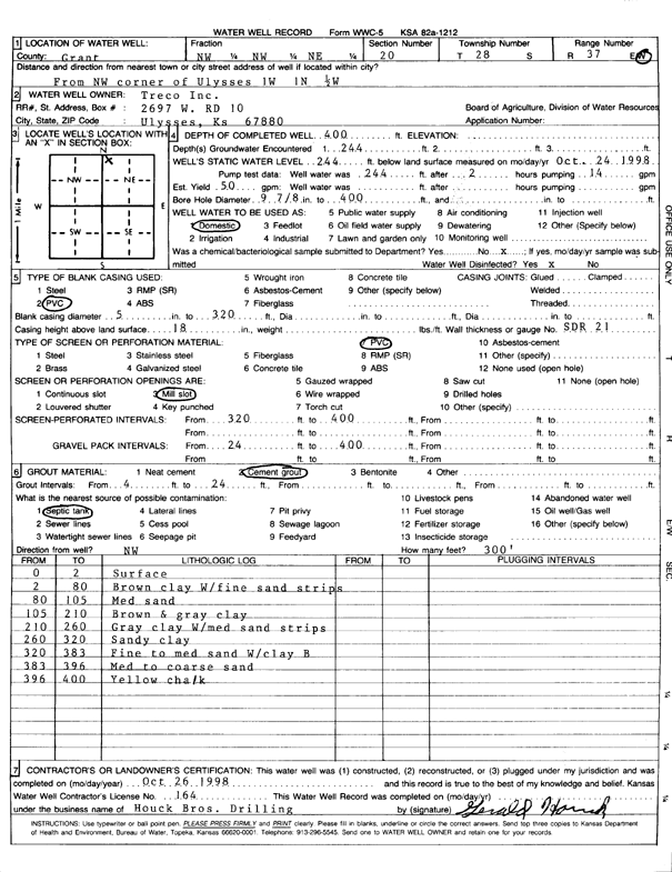
T28S, R37W, Sec. 20 NW NW NE |
Treco Inc. | 400 ft. | 244 ft. | 50 gpm. | Domestic | Constructed | 26-Oct-1998 | Scan | |
|
T28S, R37W, Sec. 21 NE SW SW |
Anadarko Petroleum Corp. | 252 ft. | 90 ft. | Domestic | Plugged | 19-Sep-1992 | |||
|
T28S, R37W, Sec. 21 SE SW NW |
City of Ulysses | 552 ft. | 228 ft. | Public Water Supply | Constructed | 20-Feb-2004 | Scan | ||
|
T28S, R37W, Sec. 21 NW NW SE |
City of Ulysses | 325 ft. | 240 ft. | Public Water Supply | Well 6 | Plugged | 09-Nov-2004 | ||
|
T28S, R37W, Sec. 21 SE SW NW |
City of Ulysses | 550 ft. | 238 ft. | Monitoring well/observation/piezometer | Constructed | 01-Nov-2002 | Scan | ||
|
T28S, R37W, Sec. 21 NW NE NW |
Dew, Charles | 400 ft. | 230 ft. | 50 gpm. | Domestic | Constructed | 18-Jan-1994 | ||
|
T28S, R37W, Sec. 21 SW SW NW |
Grant County Road Dept. | 64 ft. | 45.51 ft. | Monitoring well/observation/piezometer | MW 3 | Constructed | 04-Dec-1995 | ||
|
T28S, R37W, Sec. 21 SW SW NW |
Grant County Road Dept. | 55 ft. | Test hole/well | SB 4 Exploratory Boring | Plugged | 29-Nov-1995 | |||
|
T28S, R37W, Sec. 21 SW SW NW |
Grant County Road Dept. | 55 ft. | Test hole/well | SB 5 Exploratory boring | Plugged | 29-Nov-1995 | |||
|
T28S, R37W, Sec. 21 SW SW NW |
Grant County Road Dept. | 64 ft. | Monitoring well/observation/piezometer | MW 6 R | Constructed | 28-Mar-2007 | |||
|
T28S, R37W, Sec. 21 NW SW SW |
Grant County Road Dept. | 54.5 ft. | Test hole/well | SB 6 Exploratory Boring | Constructed | 29-Nov-1995 | |||
|
T28S, R37W, Sec. 21 SW SW NW |
Grant County Road Dept. | 45 ft. | Test hole/well | SB 7 Exploratory Boring | Plugged | 01-Dec-1995 | |||
| View page: < Prev || 11 || 12 || 13 || 14 || 15 || 16 || 17 || 18 || 19 || 20 || Next > | |||||||||