Select location of well to view details.
Click on column heading to sort.
|
|
|
County: Grant Select location of well to view details. Click on column heading to sort. |
|
|
|
| View page: < Prev || 31 || 32 | |||||||||
| T-R-S | Owner | Well Depth Ascend. Desc. |
Static Water Level Ascend. Desc. |
Est. Yield Ascend. Desc. |
Well Use | Other ID | Action Taken | Completion Date Ascend. Desc. |
Scan? |
|
T30S, R38W, Sec. 2 NW SE SE |
Kepley, Bernice | 380 ft. | 155 ft. | 110 gpm. | Oil Field Water Supply | G.R. Hickok F Unit 3 | Constructed | 14-Jul-1988 | |
|
T30S, R38W, Sec. 2 SW SW NW |
Kepley, Ralph | 353 ft. | 180 ft. | 50 gpm. | Domestic | Constructed | 17-Jun-1983 | ||
|
T30S, R38W, Sec. 2 SE SE NE |
Kepley, Ralph | 530 ft. | 170 ft. | 800 gpm. | Irrigation | Constructed | 28-Feb-1977 | ||
|
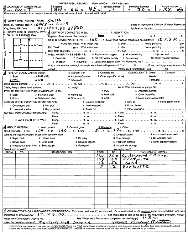
T30S, R38W, Sec. 3 NW NW NE |
Smith, Kam | 200 ft. | 160 ft. | (unstated)/abandoned | Plugged | 23-Dec-2000 | Scan | ||
|
T30S, R38W, Sec. 3 NE SW NW |
Young, Nancy K./ ARCO Oil and Gas | 400 ft. | 160 ft. | 120 gpm. | Oil Field Water Supply | Clyde Ball Unit 3 | Constructed | 20-Jul-1988 | |
|
T30S, R38W, Sec. 4 NW SW SW |
Hickok, James and Lola F./ Arco Oil and Gas | 340 ft. | 140 ft. | 120 gpm. | Oil Field Water Supply | G.R. Hickok G Unit 3 | Constructed | 27-Jul-1988 | |
|
T30S, R38W, Sec. 5 NE NE NE |
Kepley, Edward | 320 ft. | 105 ft. | 60 gpm. | Domestic | Constructed | 27-Dec-1976 | ||
|
T30S, R38W, Sec. 6 SW SW SW |
Bailey Family Trust | 530 ft. | 222 ft. | Irrigation | Constructed | 21-Dec-2003 | Scan | ||
|
T30S, R38W, Sec. 8 C W2 W2 |
Friesen Windmill and Supply | 150 ft. | 90 ft. | 3 gpm. | Domestic | Cruz | Constructed | 07-Apr-1994 | |
|
T30S, R38W, Sec. 8 SW SE SW |
Johnson, Carl | 370 ft. | 175 ft. | 75 gpm. | Other | Constructed | 21-Aug-1998 | ||
|
T30S, R38W, Sec. 8 NE NE SE |
Thomason, Dillard | 452 ft. | 103 ft. | 1092 gpm. | Irrigation | Constructed | 27-Aug-1975 | ||
|
T30S, R38W, Sec. 9 SE SE SW |
Hennigh, Robert | 538 ft. | 185 ft. | 780 gpm. | Irrigation | Constructed | 06-Oct-1975 | ||
|
T30S, R38W, Sec. 9 SE SE NE |
Johnson, Steve | 460 ft. | 220 ft. | Domestic | Constructed | 30-Mar-2007 | |||
|
T30S, R38W, Sec. 10 SW NW NE |
Elmer Hennigh T. Trust | 486 ft. | 200 ft. | Irrigation | Constructed | 23-May-1990 | |||
|
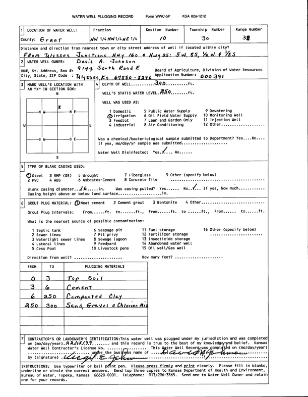
T30S, R38W, Sec. 10 NW NW NE |
Johnson, David A. | 300 ft. | 250 ft. | Irrigation | Plugged | 15-Feb-1999 | Scan | ||
|
T30S, R38W, Sec. 12 SW SW SW |
Johnson, Vergil E. | 510 ft. | 240 ft. | Irrigation | Constructed | 19-Sep-1995 | |||
|
T30S, R38W, Sec. 12 SE NE NE |
Oxy USA, Inc. | 440 ft. | 220 ft. | 85 gpm. | Oil Field Water Supply | MLP Williams A 1 | Constructed | 05-Oct-1992 | |
|
T30S, R38W, Sec. 12 SE NE NE |
Oxy USA, Inc. | 440 ft. | 220 ft. | Oil Field Water Supply | MLP Williams A 1 | Plugged | 23-Mar-1993 | ||
|
T30S, R38W, Sec. 12 SW SW SW |
Thomason, Dillard | 341 ft. | 270 ft. | 50 gpm. | Domestic | Constructed | 08-Apr-1989 | ||
|
T30S, R38W, Sec. 13 SE SW NW |
Bauer, Lyle | 521 ft. | 173 ft. | 1300 gpm. | Irrigation | Constructed | 03-Nov-1976 | ||
|
T30S, R38W, Sec. 14 NW NW SE |
EOG Resources Inc. | 500 ft. | 350 ft. | 85 gpm. | Oil Field Water Supply | Vergil 14-1 | Constructed | 28-Jun-2011 | |
|
T30S, R38W, Sec. 14 SW SW SW |
Johnson, Vergil | 500 ft. | 247 ft. | Irrigation | Constructed | 22-Mar-1995 | |||
|
T30S, R38W, Sec. 14 NE NE NE SE |
Lucas Land LLC | 530 ft. | 324 ft. | 300 gpm. | Irrigation | Constructed | 19-Oct-2016 |
KOLAR |
|
|
T30S, R38W, Sec. 14 SW SW SE SW |
Lucas Land LLC | 401 ft. | 264 ft. | 264 gpm. | Irrigation | Constructed | 27-Aug-2015 |
KOLAR |
|
|
T30S, R38W, Sec. 15 SW |
Fischer, Milton | 355 ft. | Irrigation | Constructed | 31-Dec-1979 | ||||
|
T30S, R38W, Sec. 16 NW NE SW |
Hennigh, Bob | 525 ft. | 170 ft. | 1200 gpm. | Irrigation | Constructed | 10-Mar-1977 | ||
|
T30S, R38W, Sec. 17 NE NE SW |
Linke, Bernard | 333 ft. | 200 ft. | 1583 gpm. | Irrigation | Constructed | 10-Feb-1975 | ||
|
T30S, R38W, Sec. 17 NE NW NE |
Presco Westar LLC | 470 ft. | 250 ft. | 100 gpm. | Oil Field Water Supply | Popejoy 5 B | Constructed | 17-Dec-2008 | |
|
T30S, R38W, Sec. 18 NW NW NW SE |
Oxy USA, Inc. | 360 ft. | 260 ft. | 90 gpm. | Oil Field Water Supply | Constructed | 21-Aug-2013 | ||
|
T30S, R38W, Sec. 19 NE SE |
Trans-Pacific Oil Corp. | 300 ft. | 240 ft. | 90 gpm. | Oil Field Water Supply | Davis 1-19 | Constructed | 04-Nov-1991 | |
|
T30S, R38W, Sec. 20 NE NE NE |
Smith, Lawrence | 408 ft. | 230 ft. | Domestic | Constructed | 12-Dec-2004 | |||
|
T30S, R38W, Sec. 21 NW NW NW |
MacKinnon, Dick | 420 ft. | 156 ft. | 30 gpm. | Domestic | Constructed | 04-Aug-1977 | ||
|
T30S, R38W, Sec. 23 SW NE NE |
Fischer, Milton | 350 ft. | 150 ft. | Irrigation | Plugged | 06-Feb-1995 | |||
|
T30S, R38W, Sec. 23 SE SE NW |
Fischer, Milton | 465 ft. | 160 ft. | 1000 gpm. | Irrigation | Constructed | 20-Jan-1977 | ||
|
T30S, R38W, Sec. 25 SE NW SE |
Chaffin, Lynn | 406 ft. | 230 ft. | 1275 gpm. | Irrigation | Constructed | 19-Jun-1976 | ||
|
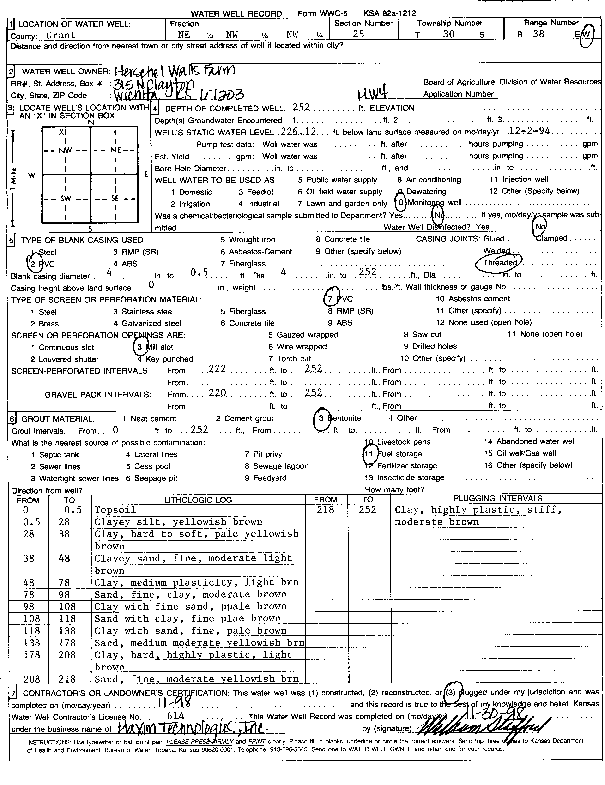
T30S, R38W, Sec. 25 NE NW NW |
Herschel Walls Farm | 252 ft. | 226 ft. | Monitoring well/observation/piezometer | MW 4 | Plugged | 30-Nov-1998 | Scan | |
|
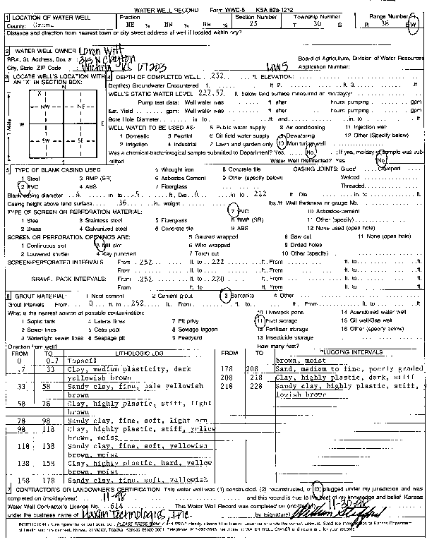
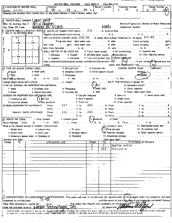
T30S, R38W, Sec. 25 NE NW NW |
Witt, Loren | 250 ft. | 226 ft. | Monitoring well/observation/piezometer | MW 2 | Constructed | 16-Nov-1994 | ||
|
T30S, R38W, Sec. 25 NE NW NW |
Witt, Loren | 243 ft. | 226.4 ft. | Monitoring well/observation/piezometer | MW 6 | Constructed | 02-Feb-1995 | ||
|
T30S, R38W, Sec. 25 NE NW NW |
Witt, Loren | 252 ft. | 226.1 ft. | Monitoring well/observation/piezometer | MW 4 | Constructed | 16-Nov-1994 | ||
|
T30S, R38W, Sec. 25 NE NW NW |
Witt, Loren | 252 ft. | 226.4 ft. | Monitoring well/observation/piezometer | MW 3 | Constructed | 16-Nov-1994 | ||
|
T30S, R38W, Sec. 25 NE NW NW |
Witt, Loren | 245 ft. | 225.8 ft. | Monitoring well/observation/piezometer | MW 1 | Constructed | 16-Nov-1994 | ||
|
T30S, R38W, Sec. 25 NE NW NW |
Witt, Loren | 252 ft. | 227.57 ft. | Monitoring well/observation/piezometer | MW 5 | Constructed | 16-Nov-1994 | ||
|
T30S, R38W, Sec. 25 NE NW NW |
Witt, Loren | 252 ft. | 227 ft. | Monitoring well/observation/piezometer | MW 5 | Plugged | 30-Nov-1998 | Scan | |
|
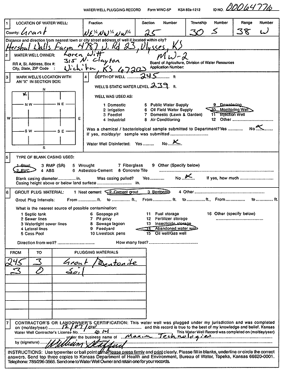
T30S, R38W, Sec. 25 NE NW NW |
Witt, Loren | 245 ft. | 239 ft. | Monitoring well/observation/piezometer | MW 1 | Plugged | 07-Dec-2000 | Scan | |
|
T30S, R38W, Sec. 25 NE NW NW |
Witt, Loren | 245 ft. | 239 ft. | Monitoring well/observation/piezometer | MW 2 | Plugged | 07-Dec-2000 | Scan | |
|
T30S, R38W, Sec. 25 NE NW NW |
Witt, Loren | 245 ft. | 226.7 ft. | Monitoring well/observation/piezometer | MW 7 | Constructed | 02-Feb-1995 | ||
|
T30S, R38W, Sec. 25 NE NW NW |
Witt, Loren | 252 ft. | 226 ft. | Monitoring well/observation/piezometer | MW 6 | Plugged | 30-Nov-1998 | Scan | |
|
T30S, R38W, Sec. 25 NE NW NW |
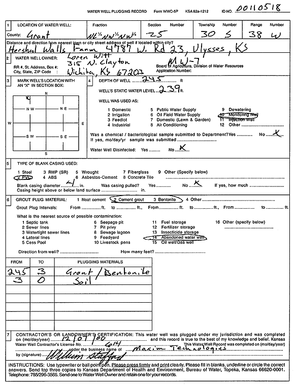
Witt, Loren | 245 ft. | 239 ft. | Monitoring well/observation/piezometer | MW 7 | Plugged | 07-Dec-2000 | Scan | |
|
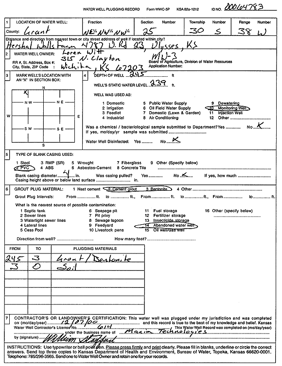
T30S, R38W, Sec. 25 NE NW NW |
Witt, Loren | 245 ft. | 239 ft. | Monitoring well/observation/piezometer | MW 3 | Plugged | 07-Dec-2000 | Scan | |
|
T30S, R38W, Sec. 26 NE SW SW |
Zinke and Trumbo Inc. | 400 ft. | 237 ft. | Oil Field Water Supply | Lewis 1-26 | Constructed | 23-Feb-2000 | ||
| View page: < Prev || 31 || 32 | |||||||||