Select location of well to view details.
Click on column heading to sort.
|
|
|
County: Grant Select location of well to view details. Click on column heading to sort. |
|
|
|
| View page: 1 || 2 || 3 || 4 || 5 || 6 || 7 || 8 || 9 || 10 || Next > | |||||||||
| T-R-S | Owner | Well Depth Ascend. Desc. |
Static Water Level Ascend. Desc. |
Est. Yield Ascend. Desc. |
Well Use | Other ID | Action Taken | Completion Date Ascend. Desc. |
Scan? |
|
T27S, R38W, Sec. 23 SW NW SW |
Hohner, Leonard | 620 ft. | 225 ft. | 1250 gpm. | Irrigation | Constructed | 22-Apr-1982 | ||
|
T27S, R38W, Sec. 23 NE NE SW |
Hohner, Leonard | 600 ft. | 220 ft. | Monitoring well/observation/piezometer | Constructed | 25-Oct-1985 | |||
|
T27S, R38W, Sec. 23 SW NW SW |
Hohner, Leonard | 620 ft. | 225 ft. | Monitoring well/observation/piezometer | Constructed | 22-Apr-1982 | |||
|
T27S, R38W, Sec. 23 SW NW SW |
Hohner, Leonard/ Higgs, Carl | 300 ft. | 265 ft. | Irrigation | Plugged | 13-Sep-1990 | |||
|
T27S, R38W, Sec. 23 NE NE SW |
Hohner, Leonard/ Higgs, Carl | 265 ft. | Irrigation | Plugged | 13-Sep-1990 | ||||
|
T27S, R38W, Sec. 23 NW SW NE |
Little, Mary | 430 ft. | 201 ft. | 1100 gpm. | Irrigation | Constructed | 10-Aug-1979 | ||
|
T27S, R38W, Sec. 23 NW NW SW |
Schredel Family Trust | 215 ft. | 176 ft. | Irrigation | Plugged | 08-Apr-1998 | |||
|
T27S, R38W, Sec. 23 NW SE NW |
Spencer, Garry | 239 ft. | Irrigation | Plugged | 02-Oct-2006 | ||||
|
T27S, R38W, Sec. 24 NW SW SW |
Shapland, Kevin | 630 ft. | Irrigation | Constructed | 16-Oct-2011 | ||||
|
T27S, R38W, Sec. 25 NE NW NW |
Fort, William T. | 357 ft. | 150 ft. | 25 gpm. | Domestic | Constructed | 26-Jun-1979 | ||
|
T27S, R38W, Sec. 26 NW SE NW NW |
Shorter, Margene | 260 ft. | 260 ft. | Irrigation | Plugged | 27-May-2017 |
KOLAR |
||
|
T27S, R38W, Sec. 26 SE NW NE |
Shorter, Mrs. Charles | 428 ft. | 232 ft. | 1200 gpm. | Irrigation | Constructed | 20-Oct-1978 | ||
|
T27S, R38W, Sec. 27 SE SW NE |
Walker, David | 420 ft. | 240 ft. | Domestic | Constructed | 13-Jan-2010 | |||
|
T27S, R38W, Sec. 27 NW NW NW |
Walker, Travis | 575 ft. | 200 ft. | 1800 gpm. | Irrigation | Constructed | 26-Jul-1977 | ||
|
T27S, R38W, Sec. 27 NW NW SW |
Walker, Travis | 447.9 ft. | 205 ft. | 1400 gpm. | Irrigation | Constructed | 25-Jul-1977 | ||
|
T27S, R38W, Sec. 27 NE SE NE |
Walker, Travis | 521 ft. | 220 ft. | Irrigation | Constructed | 20-Mar-1985 | |||
|
T27S, R38W, Sec. 28 NW SW NW |
Pucket, Cecil | 425 ft. | 235 ft. | Domestic | Constructed | 04-Sep-1980 | |||
|
T27S, R38W, Sec. 28 SE NW SW |
Pucket, Cecil | 440 ft. | Domestic | Constructed | 14-Jun-2012 | ||||
|
T27S, R38W, Sec. 30 SE SE SE |
Baker, Gary | 360 ft. | 130 ft. | Domestic | Constructed | 01-Apr-1977 | |||
|
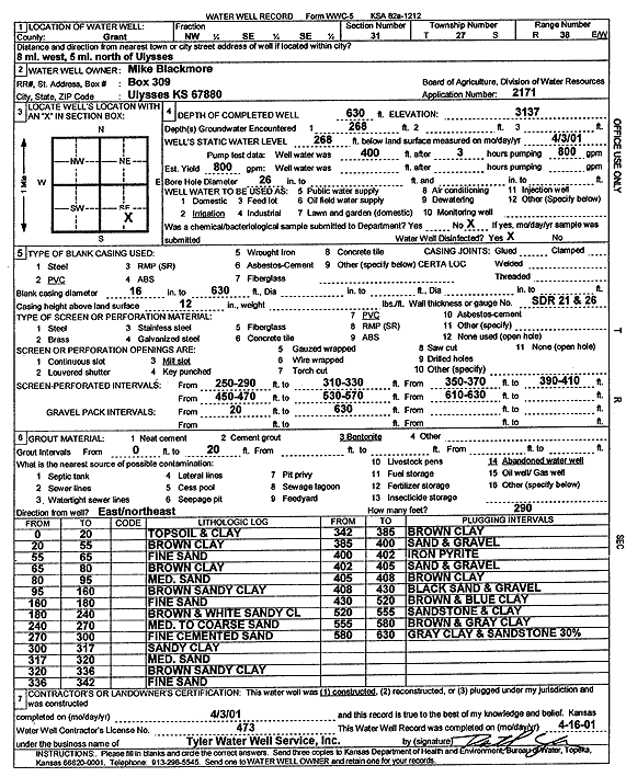
T27S, R38W, Sec. 31 NE NW NW |
Blackmore, Mike | 630 ft. | 293 ft. | Irrigation | Constructed | 30-Mar-2005 | |||
|
T27S, R38W, Sec. 31 NW |
Koop, Ira | 420 ft. | 220 ft. | Irrigation | Constructed | 30-Jun-1979 | |||
|
T27S, R38W, Sec. 31 NW SE SE |
Mike Blackmore | 630 ft. | 268 ft. | Irrigation | Constructed | 03-Apr-2001 | Scan | ||
|
T27S, R38W, Sec. 31 SW NE SW |
Rushfelt, Joy M. | 630 ft. | 262 ft. | Irrigation | Constructed | 18-Jan-2000 | Scan | ||
|
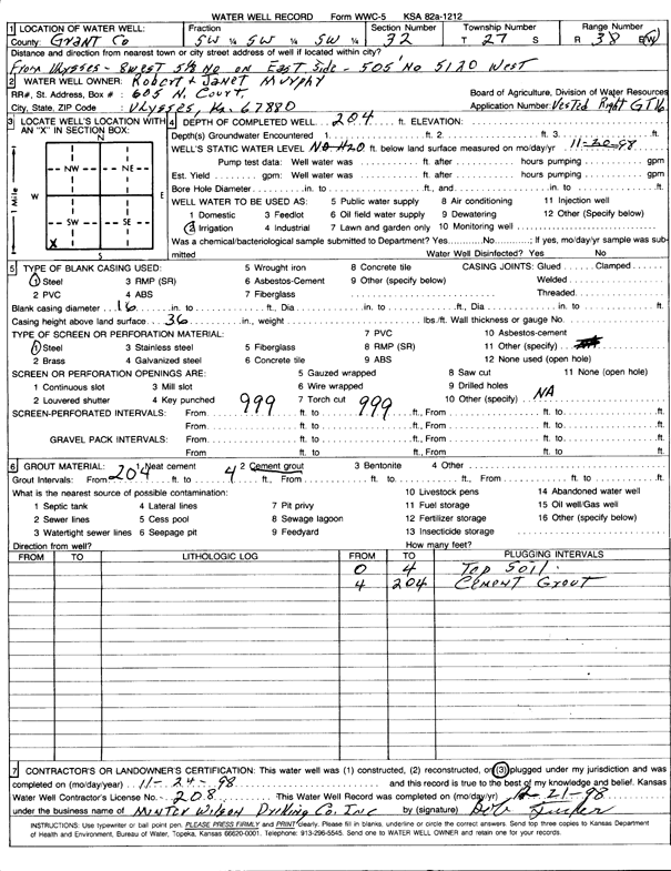
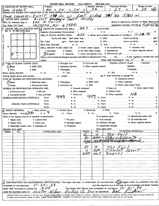
T27S, R38W, Sec. 32 NW SW SW |
Murphy, Robert | 630 ft. | 245 ft. | Irrigation | Constructed | 19-Jan-1999 | Scan | ||
|
T27S, R38W, Sec. 32 SW SW SW |
Murphy, Robert and Janet | 204 ft. | Irrigation | Plugged | 24-Nov-1998 | Scan | |||
|
T27S, R38W, Sec. 32 NW SW SW |
Murphy, Robert and Janet | 427 ft. | 255 ft. | Irrigation | Plugged | 24-Nov-1998 | Scan | ||
|
T27S, R38W, Sec. 32 NW SW NW |
Pucket, Cecil | 638 ft. | Irrigation | Plugged | 11-Jan-2005 | ||||
|
T27S, R38W, Sec. 32 NW SW NW |
Pucket, Cecil L. | 610 ft. | 338 ft. | Irrigation | Constructed | 10-Sep-2001 | Scan | ||
|
T27S, R38W, Sec. 33 SW SW SW |
Pucket, Dale | 416 ft. | 280 ft. | Domestic | Constructed | 20-Jul-1981 | |||
|
T27S, R38W, Sec. 33 NW SW SW |
Puckett, Dale | 400 ft. | 265 ft. | 10 gpm. | Domestic | Constructed | 07-Jul-1975 | ||
|
T28S, R35W, Sec. 1 NE SW SW |
Cities Service | 440 ft. | 296 ft. | 60 gpm. | Oil Field Water Supply | Stanley C 3 | Constructed | 05-Apr-1984 | |
|
T28S, R35W, Sec. 2 NW SW SE |
Koehn, Tom / Cities Service / Exeter | 420 ft. | 262 ft. | 75 gpm. | Oil Field Water Supply | McMorran A 3 | Constructed | 16-Oct-1987 | |
|
T28S, R35W, Sec. 2 NE NE SE |
Oxy USA, Inc. | 460 ft. | 260 ft. | 60 gpm. | Oil Field Water Supply | McMoran B 1 | Constructed | 15-Dec-2004 | |
|
T28S, R35W, Sec. 3 SW SW SW |
Ensz, Ron | 500 ft. | 360 ft. | Test hole/well | Plugged | 27-Feb-1989 | |||
|
T28S, R35W, Sec. 3 SW SW SW |
Ensz, Ron | 510 ft. | 360 ft. | 20 gpm. | Domestic | Constructed | 27-Feb-1989 | ||
|
T28S, R35W, Sec. 3 NW NE NW |
Koehn, Thomas | 530 ft. | 241 ft. | 25 gpm. | Domestic | Constructed | 07-Oct-1986 | ||
|
T28S, R35W, Sec. 3 NW NE NW |
Koehn, Thomas | 530 ft. | 260 ft. | 25 gpm. | Domestic | Constructed | 07-Oct-1986 | ||
|
T28S, R35W, Sec. 4 SW |
D. R. H. Farms | 391 ft. | 334 ft. | Irrigation | Plugged | 26-Nov-1991 | |||
|
T28S, R35W, Sec. 4 SW SE SW NW |
Koehn, Thomas | 725 ft. | 350 ft. | 800 gpm. | Irrigation | Constructed | 08-Apr-2013 |
KOLAR |
|
|
T28S, R35W, Sec. 4 NW SW NW |
Koehn, Thomas | 740 ft. | Irrigation | Constructed | 26-Mar-2012 | ||||
|
T28S, R35W, Sec. 4 NW SW NW |
Koehn, Thomas and Edward | 485 ft. | 264 ft. | 1320 gpm. | Irrigation | Constructed | 26-Feb-1976 | ||
|
T28S, R35W, Sec. 4 NE SE NE |
Koehn, Tom | 520 ft. | 255 ft. | 20 gpm. | Domestic | Constructed | 13-Oct-1977 | ||
|
T28S, R35W, Sec. 5 SE SW NW |
Dew Farms Inc. | 481 ft. | 300.3 ft. | 1100 gpm. | Irrigation | Constructed | 23-May-1980 | ||
|
T28S, R35W, Sec. 5 SW SW SE |
Dew, Charles | 530 ft. | Domestic | Constructed | 29-Jul-2008 | ||||
|
T28S, R35W, Sec. 5 SW SW SE |
Dew, Charles | 523.7 ft. | 308 ft. | 1500 gpm. | Irrigation | Constructed | 25-Feb-1979 | ||
|
T28S, R35W, Sec. 5 E2 SW |
Issac, Edward | 400 ft. | 290 ft. | Domestic | Constructed | 30-May-1975 | |||
|
T28S, R35W, Sec. 5 SW SW SW |
Nightingale, Sheldon | 505 ft. | 350 ft. | Domestic | Constructed | 31-Aug-2010 | |||
|
T28S, R35W, Sec. 5 SE SW SW |
Nightingale, Weldon | 520 ft. | 380 ft. | 10 gpm. | Domestic | Constructed | 28-Sep-2006 | ||
|
T28S, R35W, Sec. 6 NE NW SE |
Carroll, Maxine/ Clark, Thelma | 483 ft. | 300 ft. | 900 gpm. | Irrigation | Constructed | 10-Mar-1976 | ||
|
T28S, R35W, Sec. 6 C W2 |
Friesen Windmill and Supply/ Schmidt, Roy and Pat | 500 ft. | 325 ft. | 60 gpm. | Domestic | Constructed | 30-Nov-1991 | ||
| View page: 1 || 2 || 3 || 4 || 5 || 6 || 7 || 8 || 9 || 10 || Next > | |||||||||