Select location of well to view details.
Click on column heading to sort.
|
|
|
County: Gray Select location of well to view details. Click on column heading to sort. |
|
|
|
| View page: < Prev || 21 || 22 || 23 || 24 || 25 || 26 || 27 || 28 || 29 || 30 || Next > | |||||||||
| T-R-S | Owner | Well Depth Ascend. Desc. |
Static Water Level Ascend. Desc. |
Est. Yield Ascend. Desc. |
Well Use | Other ID | Action Taken | Completion Date Ascend. Desc. |
Scan? |
|
T26S, R28W, Sec. 11 NW SE NE |
Grasser Oil Co | 49 ft. | 39.95 ft. | Monitoring well/observation/piezometer | MW 9 | Constructed | 14-Sep-1992 | ||
|
T26S, R28W, Sec. 11 NW SE NE |
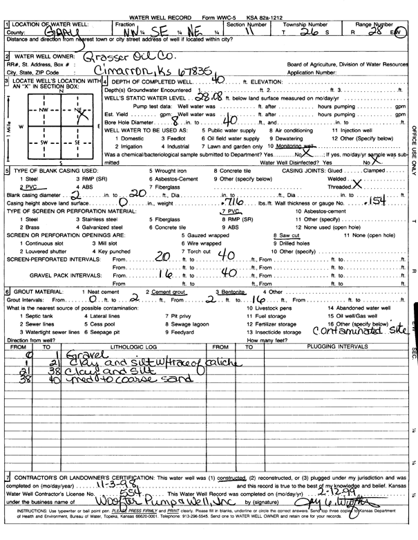
Grasser Oil Co | 40 ft. | 28.08 ft. | Monitoring well/observation/piezometer | Constructed | 03-Nov-1998 | Scan | ||
|
T26S, R28W, Sec. 11 NW SE NE |
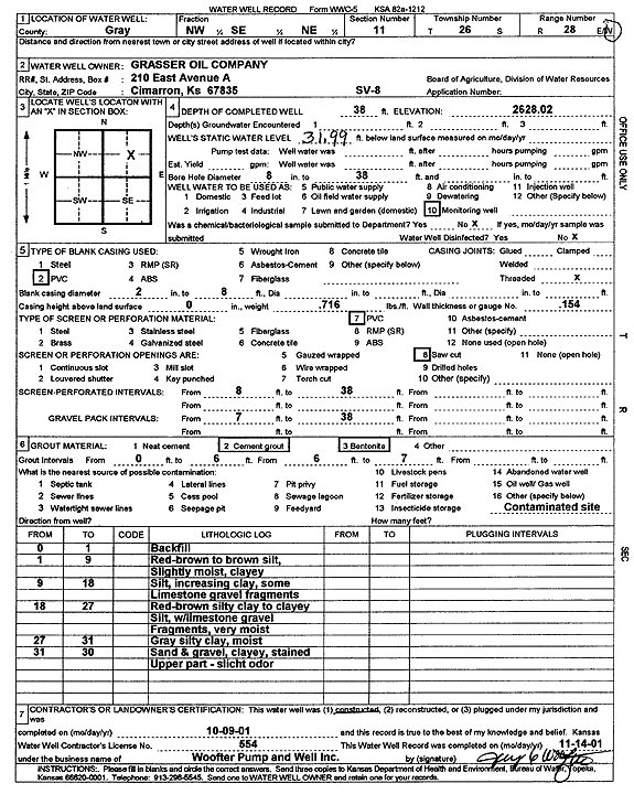
Grasser Oil Co. | 38 ft. | 31.99 ft. | Monitoring well/observation/piezometer | SV 8 | Constructed | 09-Oct-2001 | Scan | |
|
T26S, R28W, Sec. 11 NW SE NE |
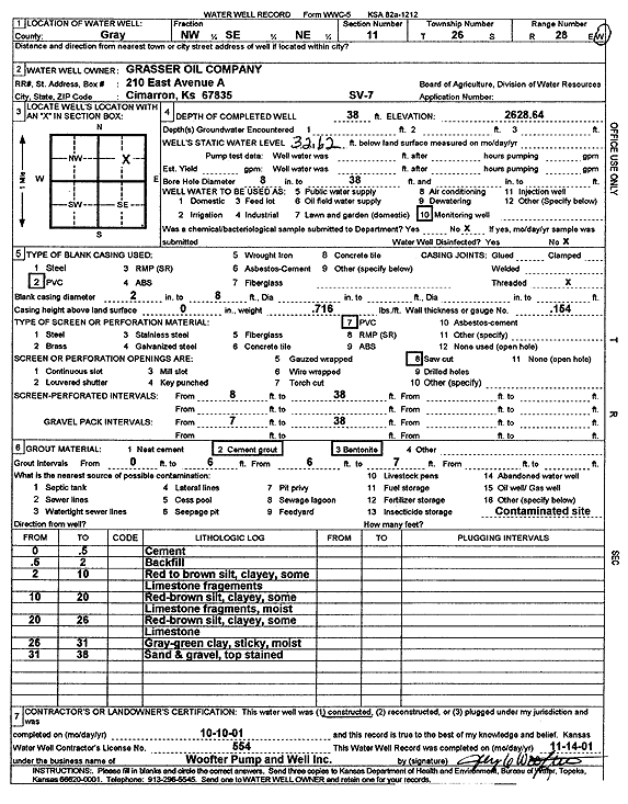
Grasser Oil Co. | 38 ft. | 32.62 ft. | Monitoring well/observation/piezometer | SV 7 | Constructed | 10-Oct-2001 | Scan | |
|
T26S, R28W, Sec. 11 NW SE NE |
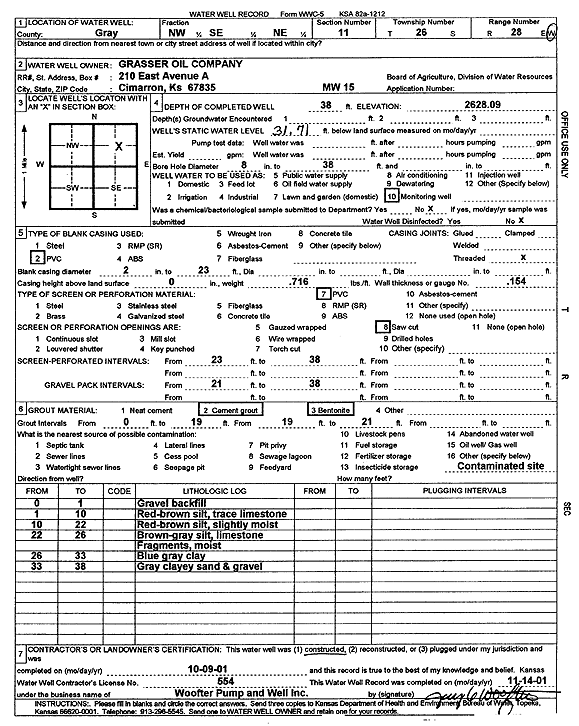
Grasser Oil Co. | 38 ft. | 31.71 ft. | Monitoring well/observation/piezometer | MW 15 | Constructed | 09-Oct-2001 | Scan | |
|
T26S, R28W, Sec. 11 SW NE NE |
Grasser Oil Co. | 40 ft. | Environmental Remediation, Air Sparge | AS 11 | Constructed | 10-Oct-2001 | Scan | ||
|
T26S, R28W, Sec. 11 NW SE NE |
Grasser Oil Co. | 47.4 ft. | 35.35 ft. | Monitoring well/observation/piezometer | MW 4 | Constructed | 21-Aug-1992 | ||
|
T26S, R28W, Sec. 11 NW SE NE |
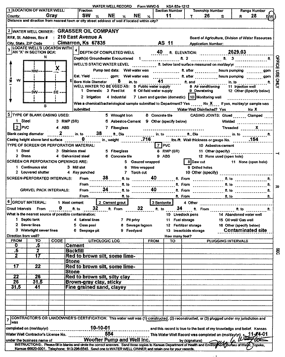
Grasser Oil Co. | 40 ft. | Environmental Remediation, Air Sparge | AS 12 | Constructed | 10-Oct-2001 | Scan | ||
|
T26S, R28W, Sec. 11 NW SE NE |
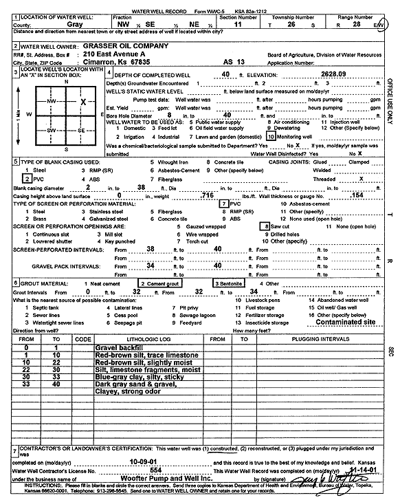
Grasser Oil Co. | 40 ft. | Environmental Remediation, Air Sparge | AS 13 | Constructed | 09-Oct-2001 | Scan | ||
|
T26S, R28W, Sec. 11 NW SE NE |
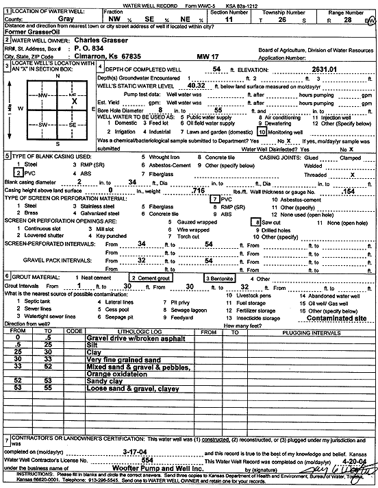
Grasser, Charles | 54 ft. | 40.32 ft. | Monitoring well/observation/piezometer | MW 17 | Constructed | 17-Mar-2004 | Scan | |
|
T26S, R28W, Sec. 11 NW SE NE |
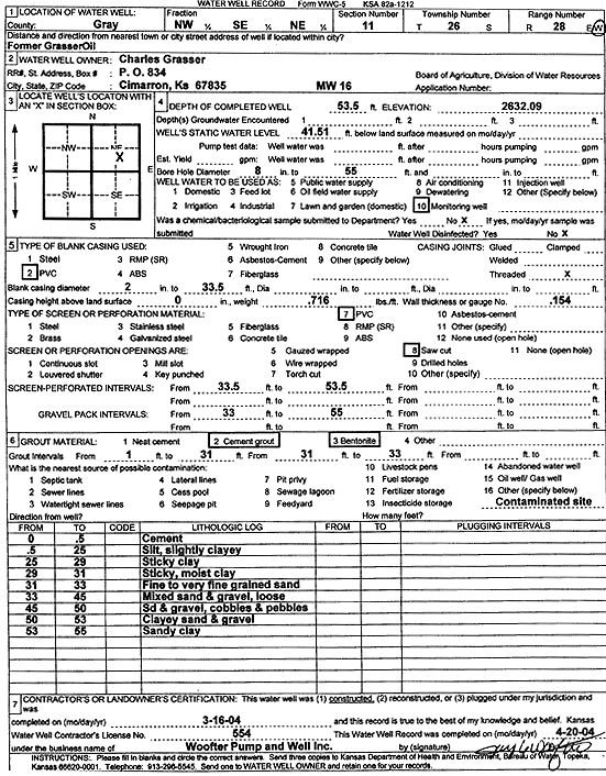
Grasser, Charles | 53.5 ft. | 41.51 ft. | Monitoring well/observation/piezometer | MW 16 | Constructed | 16-Mar-2004 | Scan | |
|
T26S, R28W, Sec. 11 NW SE NE |
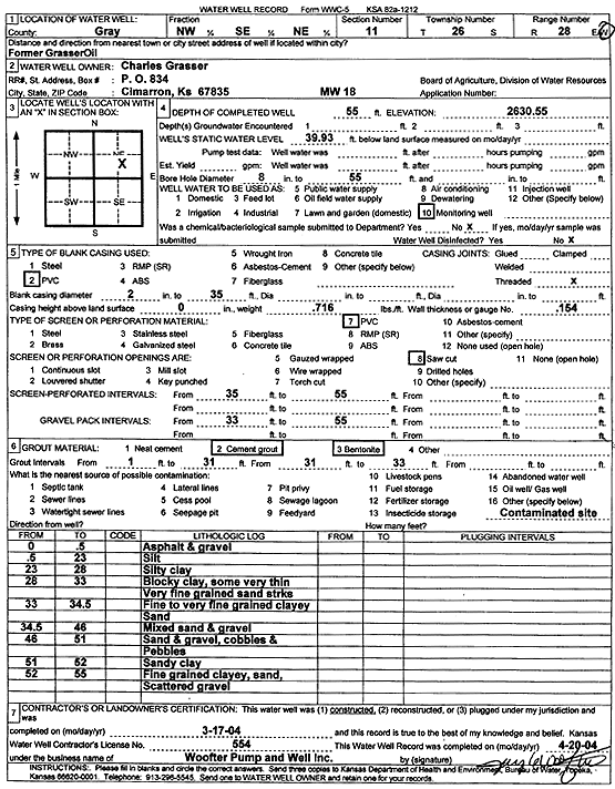
Grasser, Charles | 55 ft. | 39.93 ft. | Monitoring well/observation/piezometer | MW 18 | Constructed | 17-Mar-2004 | Scan | |
|
T26S, R28W, Sec. 11 SE SW NE |
Gray Co Court House | 174 ft. | 50 ft. | 100 gpm. | Irrigation | Plugged | 29-Jun-2004 | ||
|
T26S, R28W, Sec. 11 SW SW NE |
Gray County | Irrigation | CIM 33 | Reconstructed | 07-Dec-1989 | ||||
|
T26S, R28W, Sec. 11 SE NE NE |
Hale, Norma | 9 ft. | Domestic | CIM 179 | Plugged | 27-Mar-1990 | |||
|
T26S, R28W, Sec. 11 NE NW NW SW |
Hanna, Vernon | 55 ft. | Irrigation | Plugged | 03-Sep-2009 | ||||
|
T26S, R28W, Sec. 11 NE NW SW |
Hanna, Vernon | 46 ft. | 18 ft. | Irrigation | CIM 065 | Reconstructed | 22-Apr-1989 | ||
|
T26S, R28W, Sec. 11 NW SE NW |
Hanna, Vernon | 55 ft. | Irrigation | Plugged | 03-Sep-2009 | ||||
|
T26S, R28W, Sec. 11 NE NW SW |
Hanna, Vernon | 28 ft. | 18 ft. | Domestic | Plugged | 27-Mar-1990 | |||
|
T26S, R28W, Sec. 11 SW SE NW |
Hanna, Vernon | Domestic | Plugged | 01-Mar-1990 | |||||
|
T26S, R28W, Sec. 11 NE SE NW |
Herron, Ralph | 32 ft. | Domestic, Lawn and Garden | Plugged | 26-Mar-1990 | ||||
|
T26S, R28W, Sec. 11 NW SE NW |
Hilker, John | 23 ft. | Domestic, Lawn and Garden | CIM 69 | Plugged | 15-Mar-1990 | |||
|
T26S, R28W, Sec. 11 SE NE NE |
Hunt, Edna | 125 ft. | 38 ft. | Domestic, Lawn and Garden | CIM 40 | Plugged | 26-Mar-1990 | ||
|
T26S, R28W, Sec. 11 SE NE NW |
Immroth, Madge | Domestic | CIM 42 | Plugged | 27-Mar-1990 | ||||
|
T26S, R28W, Sec. 11 SE NE NW |
Jake Osborn 66 Service, Inc. | 60 ft. | Monitoring well/observation/piezometer | MW 12 | Constructed | 24-Mar-2005 | |||
|
T26S, R28W, Sec. 11 SE NE NW |
Jake Osborn 66 Service, Inc. | 60 ft. | Monitoring well/observation/piezometer | MW 11 | Constructed | 24-Mar-2005 | |||
|
T26S, R28W, Sec. 11 SE NE NW |
Jake Osborn 66 Service, Inc. | 60 ft. | Monitoring well/observation/piezometer | MW 14 | Constructed | 24-Mar-2005 | |||
|
T26S, R28W, Sec. 11 SE NE NW |
Jake Osborn 66 Service, Inc. | 60 ft. | Monitoring well/observation/piezometer | MW 16 | Constructed | 04-Apr-2005 | |||
|
T26S, R28W, Sec. 11 SE NE NW |
Jake Osborn 66 Service, Inc. | 60 ft. | Monitoring well/observation/piezometer | MW 15 | Constructed | 24-Mar-2005 | |||
|
T26S, R28W, Sec. 11 SE NE NW |
Jake Osborn 66 Service, Inc. | 60 ft. | Monitoring well/observation/piezometer | MW 13 | Constructed | 24-Mar-2005 | |||
|
T26S, R28W, Sec. 11 SE NE NW |
Koehn, Mary B. | Other | Plugged | 14-Jun-1990 | |||||
|
T26S, R28W, Sec. 11 SE SW NE |
Lacy, Janet | 26 ft. | 13 ft. | Domestic, Lawn and Garden | CIM 170 | Plugged | 28-Feb-1990 | ||
|
T26S, R28W, Sec. 11 NE SW NW |
Lee, Clarence | 170 ft. | 50 ft. | Irrigation | Reconstructed | 29-Nov-2007 | |||
|
T26S, R28W, Sec. 11 NW SW NE |
Litton, Kurt | 17 ft. | 17 ft. | Domestic, Lawn and Garden | CIM 31 | Plugged | 05-May-1989 | ||
|
T26S, R28W, Sec. 11 NE NE SE |
McAdam, Eugene | 30 ft. | 17 ft. | Domestic | Plugged | 17-May-1988 | |||
|
T26S, R28W, Sec. 11 SW SE SW |
McElreath, Mr. R. T. | 120 ft. | 5 ft. | 20 gpm. | Domestic | Constructed | 27-Apr-1987 | ||
|
T26S, R28W, Sec. 11 NW SW SE SW |
McElreath, Randy | 465 ft. | 145 ft. | 16 gpm. | Domestic | Reconstructed | 06-Aug-2021 |
KOLAR |
|
|
T26S, R28W, Sec. 11 NE SE SE |
McFarland, Barbara | Domestic, Lawn and Garden | CIM 138 | Reconstructed | 25-May-1989 | ||||
|
T26S, R28W, Sec. 11 SE SE NE |
McFarland, Wiley | 200 ft. | 56 ft. | Domestic | Constructed | 17-Feb-2012 | |||
|
T26S, R28W, Sec. 11 SW SW NW NW |
Nash, Trevor | 195 ft. | 104 ft. | 200 gpm. | Domestic | Constructed | 26-Apr-2019 | ||
|
T26S, R28W, Sec. 11 NW NW NE |
Omo, Ben | 60 ft. | 39 ft. | 30 gpm. | Domestic, Livestock | Constructed | 23-Nov-1982 | ||
|
T26S, R28W, Sec. 11 SE NE NW |
Osborn 66 | 43 ft. | Monitoring well/observation/piezometer | MW 4 | Plugged | 04-Apr-2005 | |||
|
T26S, R28W, Sec. 11 SE NE NW |
Osborn 66 | 35 ft. | Monitoring well/observation/piezometer | MW 8 | Plugged | 04-Apr-2005 | |||
|
T26S, R28W, Sec. 11 SE NE NW |
Osborn 66 | 74 ft. | 30.71 ft. | Monitoring well/observation/piezometer | MW 9 | Constructed | 18-Dec-2001 | Scan | |
|
T26S, R28W, Sec. 11 NE SE NW |
Osborn 66 | 35 ft. | 29.9 ft. | Monitoring well/observation/piezometer | MW 8 | Constructed | 18-Dec-2001 | Scan | |
|
T26S, R28W, Sec. 11 SE NE NW |
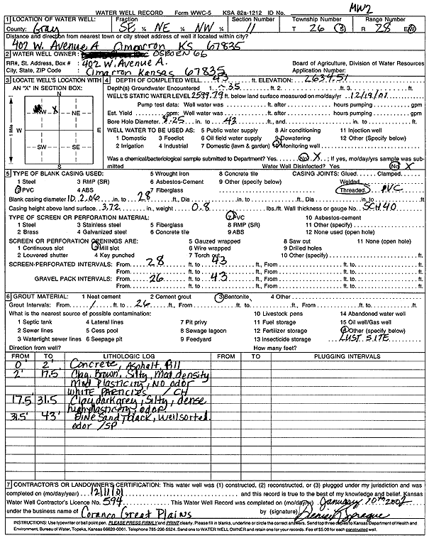
Osborn 66 | 40 ft. | 32.13 ft. | Monitoring well/observation/piezometer | MW 7 | Constructed | 13-Dec-2001 | Scan | |
|
T26S, R28W, Sec. 11 SE NE NW |
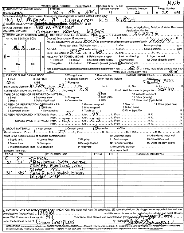
Osborn 66 | 45 ft. | 36.05 ft. | Monitoring well/observation/piezometer | MW 6 | Constructed | 13-Dec-2001 | Scan | |
|
T26S, R28W, Sec. 11 SE NE NW |
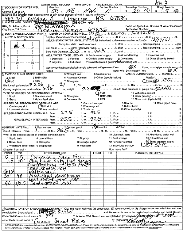
Osborn 66 | 42.5 ft. | 33.05 ft. | Monitoring well/observation/piezometer | MW 3 | Constructed | 11-Dec-2001 | Scan | |
|
T26S, R28W, Sec. 11 SE NE NW |
Osborn 66 | 42 ft. | 33.91 ft. | Monitoring well/observation/piezometer | MW 5 | Constructed | 13-Dec-2001 | Scan | |
|
T26S, R28W, Sec. 11 SE NE NW |
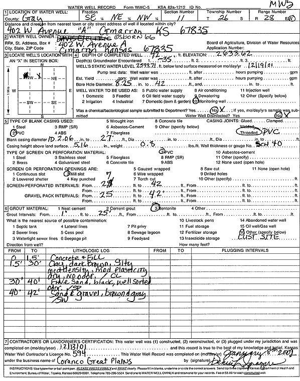
Osborn 66 | 43 ft. | 34.72 ft. | Monitoring well/observation/piezometer | MW 2 | Constructed | 11-Dec-2001 | Scan | |
| View page: < Prev || 21 || 22 || 23 || 24 || 25 || 26 || 27 || 28 || 29 || 30 || Next > | |||||||||