Select location of well to view details.
Click on column heading to sort.
|
|
|
County: Gray Select location of well to view details. Click on column heading to sort. |
|
|
|
| View page: < Prev || 41 || 42 || 43 || 44 || 45 || 46 || 47 || 48 || 49 || 50 || Next > | |||||||||
| T-R-S | Owner | Well Depth Ascend. Desc. |
Static Water Level Ascend. Desc. |
Est. Yield Ascend. Desc. |
Well Use | Other ID | Action Taken | Completion Date Ascend. Desc. |
Scan? |
|
T28S, R28W, Sec. 16 SW SW SW |
Elson, Charlres | Domestic, Livestock | Constructed | 25-Nov-1977 | |||||
|
T28S, R28W, Sec. 20 SW SW SW |
Bindley, Mrs. Lyle | 175 ft. | 150 ft. | 10 gpm. | Domestic | Constructed | 24-Aug-1990 | ||
|
T28S, R28W, Sec. 20 SW SW SW |
Bindley, Mrs. Lyle | 150 ft. | 149 ft. | Domestic | Plugged | 24-Aug-1990 | |||
|
T28S, R28W, Sec. 21 NW NW SW |
Koehn, Evan | 200 ft. | 120 ft. | Domestic | Constructed | 24-Jul-1997 | |||
|
T28S, R28W, Sec. 24 NW SW SW |
Bryant, Gary | 460 ft. | 267 ft. | 35 gpm. | Domestic, Livestock | Constructed | 15-Jun-2022 | ||
|
T28S, R28W, Sec. 25 NE SW SE SE |
Blattner Feedlot Construction | 165 ft. | 108 ft. | 20 gpm. | Domestic, Livestock | Reconstructed | 10-Nov-2021 |
KOLAR |
|
|
T28S, R28W, Sec. 25 SW SW SE NE |
Blattner, Rick | 190 ft. | 166 ft. | 3 gpm. | Domestic, Livestock | Constructed | 05-Feb-2012 |
KOLAR |
|
|
T28S, R28W, Sec. 26 SW NW NW |
Johnson, Norval | 160 ft. | 143 ft. | Domestic | Constructed | 02-Apr-1991 | |||
|
T28S, R28W, Sec. 27 NE SW SE |
Scroggins, Art | 291 ft. | 61 ft. | 1100 gpm. | Irrigation | Constructed | 01-Aug-1975 | ||
|
T28S, R28W, Sec. 29 SW NW NW |
Hendrickson, Roy | 163 ft. | 128 ft. | 4 gpm. | Domestic | Constructed | 12-Mar-1980 | ||
|
T28S, R28W, Sec. 30 NW NW NE |
Nichols, Mark | 465 ft. | 141 ft. | Domestic | Constructed | 03-May-2024 |
KOLAR |
||
|
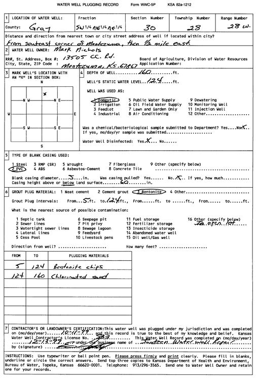
T28S, R28W, Sec. 30 SW NW NE |
Nichols, Mark | 160 ft. | 124 ft. | Domestic | Plugged | 11-Oct-1999 | Scan | ||
|
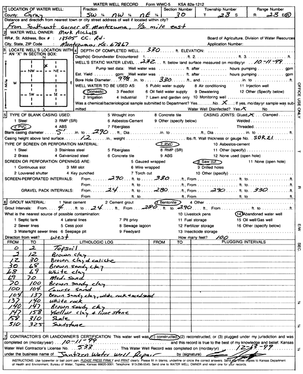
T28S, R28W, Sec. 30 SW NW NE |
Nichols, Mark | 330 ft. | 232 ft. | Domestic | Constructed | 11-Oct-1999 | Scan | ||
|
T28S, R28W, Sec. 34 SE NE SW NW |
Unruh, Ross | 180 ft. | 121 ft. | 18 gpm. | Domestic | Constructed | 14-Apr-2018 | ||
|
T28S, R29W, Sec. 2 SE SE SE SW |
Koehn, Earl | 295 ft. | 167 ft. | Domestic | Reconstructed | 21-Jun-2016 | |||
|
T28S, R29W, Sec. 2 NE |
Koehn, William P | 196 ft. | 153 ft. | Irrigation | Plugged | 27-Aug-1990 | |||
|
T28S, R29W, Sec. 2 SW SW SW NE |
Love, Gregory C | 140 ft. | Environmental Remediation, Soil Vapor Extraction | SVE 3 | Constructed | 07-Jul-2017 | |||
|
T28S, R29W, Sec. 3 SE SE SW |
Koehn Jr, Henry | 153 ft. | 134 ft. | Domestic | Plugged | 12-Sep-1994 | |||
|
T28S, R29W, Sec. 3 SE SE SW |
Koehn Jr, Henry | 101 ft. | Domestic | Plugged | 12-Sep-1994 | ||||
|
T28S, R29W, Sec. 3 SE SE SE |
Toews, Rod | 440 ft. | 210 ft. | Domestic | Constructed | 12-May-2004 | |||
|
T28S, R29W, Sec. 3 SE SE SE |
Toews, Rod | 175 ft. | 162 ft. | Domestic | Plugged | 13-May-2004 | |||
|
T28S, R29W, Sec. 3 SW SW SW SE |
Toews, Rodney | 590 ft. | 285 ft. | Domestic | Reconstructed | 12-Sep-2018 | |||
|
T28S, R29W, Sec. 3 SW NE NE |
Unruh, Denton | 197 ft. | 124 ft. | 1425 gpm. | Irrigation | Constructed | 29-Mar-1976 | ||
|
T28S, R29W, Sec. 3 SE NW NW |
Unruh, Denton | 195 ft. | 121 ft. | 30 gpm. | Domestic | Constructed | 28-Apr-1981 | ||
|
T28S, R29W, Sec. 3 NW SW NW |
Unruh, Denton | 188 ft. | 127 ft. | 5 gpm. | Domestic | Constructed | 15-May-1981 | ||
|
T28S, R29W, Sec. 5 SE SE SE |
Banach, Glenn | 292 ft. | 155 ft. | 15 gpm. | Domestic | Constructed | 12-Sep-1980 | ||
|
T28S, R29W, Sec. 5 SW SE SW |
Yost, Walter | 335 ft. | 138 ft. | 1600 gpm. | Irrigation | Constructed | 31-Jul-1980 | ||
|
T28S, R29W, Sec. 6 SW NE NE |
Koehn, Alvin B | 360 ft. | 241 ft. | 40 gpm. | Domestic | Constructed | 13-Jul-1994 | ||
|
T28S, R29W, Sec. 6 SW SW NE |
Koehn, Alvin B | 358 ft. | 120 ft. | 1400 gpm. | Irrigation | Constructed | 10-Nov-1975 | ||
|
T28S, R29W, Sec. 6 SE SE SW |
Koehn, Roy | 505 ft. | 198 ft. | Domestic | Constructed | 08-Aug-2006 | |||
|
T28S, R29W, Sec. 6 NE NE NE SE |
Nichols, Carrie | 335 ft. | 185 ft. | 16 gpm. | Domestic | Reconstructed | 01-Nov-2017 | ||
|
T28S, R29W, Sec. 6 SE NE SW NW |
Yost, Robbie | 380 ft. | 260 ft. | 903 gpm. | Irrigation | Constructed | 22-May-2013 |
KOLAR |
|
|
T28S, R29W, Sec. 7 NW SW SE |
Koehn, Calvin C | 321 ft. | 134 ft. | 560 gpm. | Irrigation | Plugged | 26-Dec-1991 | ||
|
T28S, R29W, Sec. 7 SW SE SW |
Smith, Dave | 240 ft. | 145 ft. | 100 gpm. | Domestic | Constructed | 10-May-1976 | ||
|
T28S, R29W, Sec. 8 SE SE SW |
Buller, Vernon | 381 ft. | 185 ft. | 25 gpm. | Domestic | Constructed | 22-Sep-1995 | ||
|
T28S, R29W, Sec. 8 NW NW SE |
Koehn, John Mark | 308 ft. | 198 ft. | 450 gpm. | Irrigation | Constructed | 02-Jul-2024 |
KOLAR |
|
|
T28S, R29W, Sec. 8 NW NW SE |
Koehn, John Mark | 167 ft. | Irrigation | Plugged | 20-Jan-2026 |
KOLAR |
|||
|
T28S, R29W, Sec. 8 NE |
Schmidt, Melvin | 335 ft. | 135 ft. | 900 gpm. | Irrigation | Constructed | 22-Apr-1975 | ||
|
T28S, R29W, Sec. 8 NW NW NW |
Wiley, Charles | 430 ft. | 149 ft. | 18 gpm. | Domestic | Constructed | 12-Nov-1982 | ||
|
T28S, R29W, Sec. 9 SE SE NE |
Banach, Glenn | 195 ft. | 164 ft. | Domestic | Constructed | 31-Mar-1995 | |||
|
T28S, R29W, Sec. 10 NE NE SW |
Jantz, Max | 430 ft. | 180 ft. | 25 gpm. | Domestic | Constructed | 07-Jun-2004 | Scan | |
|
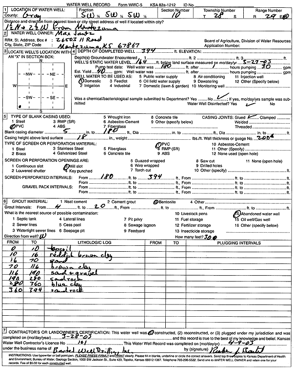
T28S, R29W, Sec. 10 SW SW SW |
Jantz, Max | 394 ft. | 164 ft. | 40 gpm. | Domestic | Constructed | 28-Mar-2003 | Scan | |
|
T28S, R29W, Sec. 10 NW SW NE |
Jantz, Max | 183 ft. | 181 ft. | Irrigation | Plugged | 04-Apr-1991 | |||
|
T28S, R29W, Sec. 10 NE NE SW |
Jantz, Max | 520 ft. | 198 ft. | Domestic | Constructed | 07-Jul-2005 | |||
|
T28S, R29W, Sec. 10 NE NE SW |
Jantz, Max | 430 ft. | 198 ft. | Domestic | Plugged | 07-Jul-2005 | |||
|
T28S, R29W, Sec. 10 SE SW NE |
Max Jantz Excavating LLC | 520 ft. | 308 ft. | Domestic | Constructed | 14-May-2026 |
KOLAR |
||
|
T28S, R29W, Sec. 10 SW SW SW |
Max Jantz Excavating LLC | 545 ft. | 227 ft. | Domestic | Constructed | 17-Oct-2007 | |||
|
T28S, R29W, Sec. 10 SE SE SW |
Mennonite Church | 264 ft. | 165 ft. | 11 gpm. | Domestic | Constructed | 15-Jul-1976 | ||
|
T28S, R29W, Sec. 10 SW SW SW SE |
Montezuma Church | 545 ft. | 280 ft. | Domestic | Reconstructed | 15-Dec-2012 | |||
|
T28S, R29W, Sec. 10 NE SE SW |
Montezuma Mennonite Church | 485 ft. | 280 ft. | Domestic | Plugged | 25-Nov-2012 | |||
| View page: < Prev || 41 || 42 || 43 || 44 || 45 || 46 || 47 || 48 || 49 || 50 || Next > | |||||||||