Select location of well to view details.
Click on column heading to sort.
|
|
|
County: Barber Select location of well to view details. Click on column heading to sort. |
|
|
|
| View page: < Prev || 11 || 12 || 13 || 14 || 15 || 16 || 17 || 18 || 19 || 20 || Next > | |||||||||
| T-R-S | Owner | Well Depth Ascend. Desc. |
Static Water Level Ascend. Desc. |
Est. Yield Ascend. Desc. |
Well Use | Other ID | Action Taken | Completion Date Ascend. Desc. |
Scan? |
|
T31S, R11W, Sec. 15 SE SW SW |
Globe Operating/Ralph Dick | 100 ft. | 41 ft. | Oil Field Water Supply | Constructed | 09-Feb-2007 | |||
|
T31S, R11W, Sec. 15 NE NW |
Hellman, Steve | 120 ft. | 56 ft. | 75 gpm. | Domestic, Livestock | Constructed | 17-Apr-2017 | ||
|
T31S, R11W, Sec. 16 NE SW SE |
Globe Operating | 142 ft. | 89 ft. | 40 gpm. | Oil Field Water Supply | Constructed | 01-Mar-2006 | ||
|
T31S, R11W, Sec. 16 SE NW SE |
Watkins, Ivan | 110 ft. | 86 ft. | Domestic | Plugged | 11-Apr-2007 | |||
|
T31S, R11W, Sec. 17 NW SW NE |
Chain Ranch | 150 ft. | 90 ft. | 10 gpm. | Domestic | Constructed | 15-Aug-1986 | ||
|
T31S, R11W, Sec. 18 NE NE SW |
Chain Ranch | 52 ft. | 11 ft. | 25 gpm. | Domestic | Constructed | 22-Jul-1983 | ||
|
T31S, R11W, Sec. 19 SE SW NW |
Chain Ranch | 58 ft. | 16 ft. | 8 gpm. | Domestic | Constructed | 20-Nov-1989 | ||
|
T31S, R11W, Sec. 19 NW NW NE |
City of Medicine Lodge | 40 ft. | 6 ft. | 50 gpm. | Monitoring well/observation/piezometer | Constructed | 10-Jan-1984 | ||
|
T31S, R11W, Sec. 19 NW NW NW |
City of Medicine Lodge | 52 ft. | 5 ft. | 25 gpm. | Monitoring well/observation/piezometer | Constructed | 26-Oct-1983 | ||
|
T31S, R11W, Sec. 19 NE SW SE |
Lawrence, Dallas | 82 ft. | 52 ft. | 10 gpm. | Domestic | Constructed | 02-Jan-1982 | ||
|
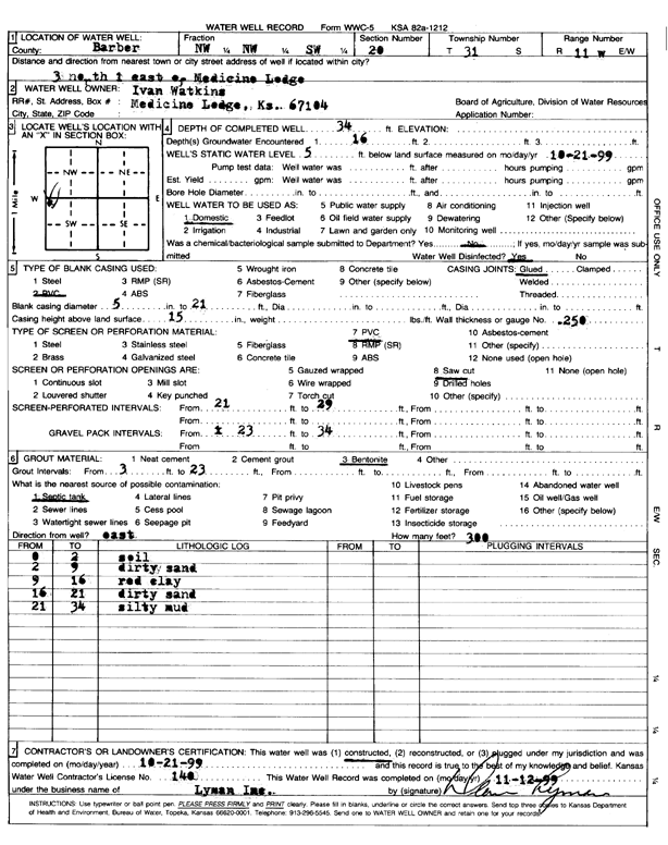
T31S, R11W, Sec. 20 NW NW SW |
Watkins, Ivan | 34 ft. | 5 ft. | Domestic | Constructed | 21-Oct-1999 | Scan | ||
|
T31S, R11W, Sec. 20 NW NW SW |
Watkins, Ivan | 63 ft. | 8.5 ft. | 20 gpm. | Domestic | Constructed | 05-Sep-2012 | ||
|
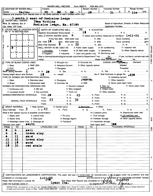
T31S, R11W, Sec. 20 NE NW SW |
Watkins, Ivan | 32 ft. | 4 ft. | 10 gpm. | Domestic | Constructed | 11-Jan-1999 | Scan | |
|
T31S, R11W, Sec. 20 SE SE NW |
Watkins, Ivan M. | 30 ft. | 4 ft. | 4 gpm. | Feedlot | Constructed | 05-Oct-1988 | ||
|
T31S, R11W, Sec. 21 NE NW NE |
DaMac Drilling Inc. | 125 ft. | 75 ft. | 60 gpm. | Oil Field Water Supply | Constructed | 05-Sep-1980 | ||
|
T31S, R11W, Sec. 27 SW SW |
Cally, Dennis | 30 ft. | 15 ft. | Domestic | Constructed | 20-Jan-1976 | |||
|
T31S, R11W, Sec. 27 SE NW SW |
Colle, Dennis | 62 ft. | 37 ft. | 10 gpm. | Domestic, Livestock | Constructed | 20-May-2014 | ||
|
T31S, R11W, Sec. 27 NW NW SW |
Stephenson, H.M. | 62 ft. | 32.5 ft. | 20 gpm. | Domestic | Constructed | 14-Aug-1998 | ||
|
T31S, R11W, Sec. 30 NE NE NE |
Chapin, Ted | 40 ft. | 18 ft. | 25 gpm. | Domestic, Livestock | Constructed | 08-Jul-1977 | ||
|
T31S, R11W, Sec. 30 C SW SW |
Gabbert-Jones, Inc. | 65 ft. | 10 ft. | 60 gpm. | Oil Field Water Supply | Constructed | 27-Nov-1978 | ||
|
T31S, R11W, Sec. 30 SE NE SW |
Indian Oil Co., Inc. | 75 ft. | 14 ft. | Oil Field Water Supply | Constructed | 15-Mar-2014 | |||
|
T31S, R11W, Sec. 30 NW SW SE |
Lario Oil and Gas | 70 ft. | 10 ft. | Oil Field Water Supply | Plugged | 14-Oct-2013 | |||
|
T31S, R11W, Sec. 30 NW SW SE |
Lario Oil and Gas | 70 ft. | 9 ft. | Oil Field Water Supply | Plugged | 16-Jan-2013 | |||
|
T31S, R11W, Sec. 30 SW SW SE |
Lario Oil and Gas | 52 ft. | 11 ft. | Oil Field Water Supply | Constructed | 05-Dec-2014 | |||
|
T31S, R11W, Sec. 30 NW SW SE |
Lario Oil and Gas | 70 ft. | 10 ft. | Oil Field Water Supply | Constructed | 10-Aug-2012 | |||
|
T31S, R11W, Sec. 30 SW SW NE |
Lawrence, Dallas | 32 ft. | 13 ft. | 15 gpm. | Domestic | Constructed | 07-Jun-2007 | ||
|
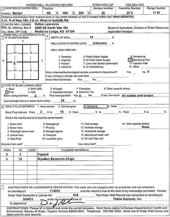
T31S, R11W, Sec. 30 NE NW SW |
Lawrence, Dallas | 15 ft. | Monitoring well/observation/piezometer | Well 2000702 | Plugged | 06-Nov-2002 | Scan | ||
|
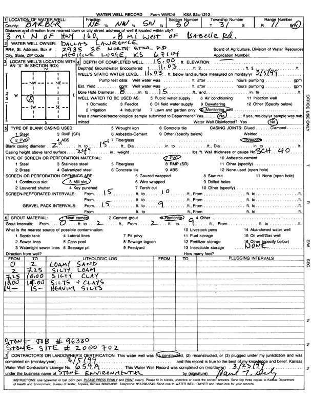
T31S, R11W, Sec. 30 NE NW SW |
Lawrence, Dallas | 15 ft. | 11.03 ft. | Monitoring well/observation/piezometer | Well 2000702 | Constructed | 05-Mar-1999 | Scan | |
|
T31S, R11W, Sec. 31 NW SE NE |
Swartz Fern Trust | 30 ft. | 4 ft. | 3 gpm. | Domestic, Livestock | Constructed | 06-Apr-2019 | ||
|
T31S, R11W, Sec. 31 SE NE SE |
Swartz, Fern | 52 ft. | 5 ft. | 10 gpm. | Domestic, Livestock | Constructed | 30-Oct-2018 | ||
|
T31S, R12W, Sec. 2 SW NW NE |
Broce Construction | 32 ft. | 7 ft. | 50 gpm. | Industrial | Constructed | 03-Jul-1984 | ||
|
T31S, R12W, Sec. 5 NW SE SE |
Clark, Charles | 35 ft. | 9.5 ft. | 200 gpm. | Irrigation | Constructed | 06-Aug-1977 | ||
|
T31S, R12W, Sec. 6 NE SE NE |
Keller Ranch | 76 ft. | 57 ft. | 7 gpm. | Domestic, Livestock | Constructed | 30-Mar-2016 | ||
|
T31S, R12W, Sec. 8 NW NW NW |
Coss, Cliff | 36 ft. | 5 ft. | 25 gpm. | Domestic | Constructed | 16-Feb-1977 | ||
|
T31S, R12W, Sec. 12 SE NE SE |
Graves Drilling Co./Bill Wiscaver | 59 ft. | 25 ft. | 25 gpm. | Oil Field Water Supply | Wiscaver 1 | Constructed | 30-Oct-1991 | |
|
T31S, R12W, Sec. 12 C NW SE |
H-30 Drilling, Inc. | 38 ft. | 28 ft. | 50 gpm. | Oil Field Water Supply | Constructed | 16-Feb-1981 | ||
|
T31S, R12W, Sec. 12 NE NW |
Parr, T.J. | 132 ft. | Test hole/well | Plugged | 01-Dec-1974 | ||||
|
T31S, R12W, Sec. 13 C NE NW |
H-30 Drilling, Inc. | 33 ft. | 5 ft. | 60 gpm. | Oil Field Water Supply | Chain Ranch B 1 | Constructed | 01-Jul-1981 | |
|
T31S, R12W, Sec. 13 SE SE NW |
Mott, Jackson | 22 ft. | 5 ft. | 20 gpm. | Domestic | Constructed | 13-May-1989 | ||
|
T31S, R12W, Sec. 15 NE SE SE NW |
Cargill Ranch | 220 ft. | 142 ft. | 1.5 gpm. | Domestic, Livestock | Constructed | 24-Jul-2013 |
KOLAR |
|
|
T31S, R12W, Sec. 20 NW |
Calloway, E.B. and T.J. Parr | 26 ft. | 9 ft. | 3 gpm. | Domestic | Constructed | |||
|
T31S, R12W, Sec. 21 SE SE NE NW |
Cargill Ranch | 200 ft. | 107 ft. | 2 gpm. | Domestic, Livestock | Constructed | 24-Jul-2013 |
KOLAR |
|
|
T31S, R12W, Sec. 23 NE SW SE |
Cargill, Chad | Domestic, changed from Oil Field Water Supply | Pike/Updegraff 2 | Reconstructed | 19-Apr-2011 | ||||
|
T31S, R12W, Sec. 23 NE SW SE |
Cargill, Chad | Domestic, changed from Oil Field Water Supply | Pike/Updegraff 2 | Reconstructed | 19-Apr-2011 | ||||
|
T31S, R12W, Sec. 23 NW SE NE SW |
Cargill, Chad | 197 ft. | 90 ft. | 5 gpm. | Domestic | Constructed | 08-Apr-2011 | ||
|
T31S, R12W, Sec. 23 SE SE NW |
Cargill, Chad and Patrica | 199 ft. | 100 ft. | 10 gpm. | Domestic | Constructed | 14-Apr-2011 | ||
|
T31S, R12W, Sec. 23 SE NE NW SW |
Kelley, Evan | 369 ft. | 17 ft. | 7 gpm. | Domestic, Lawn and Garden | Reconstructed | 13-Aug-2013 |
KOLAR |
|
|
T31S, R12W, Sec. 24 SW NE |
Barber Co. Highway Dept. | 31 ft. | Test Hole, Uncased | 3 | Constructed | 06-Feb-1965 | |||
|
T31S, R12W, Sec. 24 SW NE |
Barber Co. Highway Dept. | 21 ft. | Test Hole, Uncased | 4 | Constructed | 06-Feb-1965 | |||
|
T31S, R12W, Sec. 24 SW NE |
Barber Co. Highway Dept. | 42 ft. | Test Hole, Uncased | 2 | Constructed | 06-Feb-1965 | |||
| View page: < Prev || 11 || 12 || 13 || 14 || 15 || 16 || 17 || 18 || 19 || 20 || Next > | |||||||||