Select location of well to view details.
Click on column heading to sort.
|
|
|
County: Barber Select location of well to view details. Click on column heading to sort. |
|
|
|
| View page: < Prev || 11 || 12 || 13 || 14 || 15 || 16 || 17 || 18 || 19 || 20 || Next > | |||||||||
| T-R-S | Owner | Well Depth Ascend. Desc. |
Static Water Level Ascend. Desc. |
Est. Yield Ascend. Desc. |
Well Use | Other ID | Action Taken | Completion Date Ascend. Desc. |
Scan? |
|
T31S, R12W, Sec. 24 SW NE |
Barber Co. Highway Dept. | 21 ft. | Test Hole, Uncased | 1 | Constructed | 06-Feb-1965 | |||
|
T31S, R12W, Sec. 24 SW SW SE |
City of Medicine Lodge | 32 ft. | 15 ft. | 30 gpm. | Dewatering | Plugged | 01-Apr-2010 | ||
|
T31S, R12W, Sec. 24 SW SW SE |
City of Medicine Lodge | 32 ft. | 15 ft. | 30 gpm. | Dewatering | Constructed | 07-Mar-2010 | ||
|
T31S, R12W, Sec. 24 SW SW SE |
City of Medicine Lodge | 32 ft. | 15 ft. | 30 gpm. | Dewatering | Constructed | 07-Mar-2010 | ||
|
T31S, R12W, Sec. 24 SW SW SE |
City of Medicine Lodge | 32 ft. | 15 ft. | 30 gpm. | Dewatering | Plugged | 01-Apr-2010 | ||
|
T31S, R12W, Sec. 24 SW SW SE |
City of Medicine Lodge | 32 ft. | 15 ft. | 30 gpm. | Dewatering | Constructed | 07-Mar-2010 | ||
|
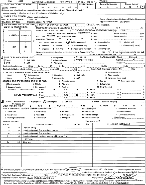
T31S, R12W, Sec. 24 SE SW SE |
City of Medicine Lodge | 27 ft. | 6 ft. | Public Water Supply | Well 12 | Constructed | 18-Nov-2002 | Scan | |
|
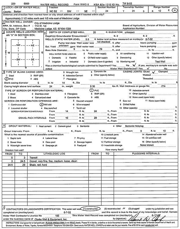
T31S, R12W, Sec. 24 S2 SW SE |
City of Medicine Lodge | 26 ft. | 5.5 ft. | Test hole/well | TW 8-02 | Constructed | 07-Jun-2002 | Scan | |
|
T31S, R12W, Sec. 24 SW SW SE |
City of Medicine Lodge | 32 ft. | 15 ft. | 30 gpm. | Dewatering | Plugged | 01-Apr-2010 | ||
|
T31S, R12W, Sec. 24 SW SW SE |
City of Medicine Lodge | 32 ft. | 15 ft. | 30 gpm. | Dewatering | Plugged | 01-Apr-2010 | ||
|
T31S, R12W, Sec. 24 C S2 SW SE |
City of Medicine Lodge | 24 ft. | 11.21 ft. | Test hole/well | TW 8-02 | Plugged | 20-Feb-2003 | ||
|
T31S, R12W, Sec. 24 SE SW NW SE |
City of Medicine Lodge | 40 ft. | 6 ft. | Public Water Supply | Water Well 6 C 14 | Plugged | 06-Sep-2017 | ||
|
T31S, R12W, Sec. 24 SE SW NW SE |
City of Medicine Lodge | 41 ft. | 6 ft. | Public Water Supply | Water Well 6 A 16 | Plugged | 06-Sep-2017 | ||
|
T31S, R12W, Sec. 24 SE NW NE SE |
City of Medicine Lodge | 51 ft. | 8 ft. | 400 gpm. | Public Water Supply | 17 | Constructed | 03-Apr-2017 | |
|
T31S, R12W, Sec. 24 NW NW SE SE |
City of Medicine Lodge | 45 ft. | 4 ft. | 400 gpm. | Public Water Supply | 18 | Constructed | 26-Apr-2017 | |
|
T31S, R12W, Sec. 24 SE SW NW SE |
City of Medicine Lodge | 40 ft. | 6 ft. | Public Water Supply | Water Well 6 D 15 | Plugged | 06-Sep-2017 | ||
|
T31S, R12W, Sec. 24 SW NW SE |
City of Medicine Lodge | 35 ft. | 7 ft. | 150 gpm. | Public Water Supply | Well 3 | Constructed | 04-Feb-1990 | |
|
T31S, R12W, Sec. 24 NE SW SE |
City of Medicine Lodge | 26 ft. | 8 ft. | Public Water Supply | Well 4 replacement | Constructed | 16-Jul-1986 | ||
|
T31S, R12W, Sec. 24 SW NW SE |
City of Medicine Lodge | 32 ft. | 8 ft. | 100 gpm. | Public Water Supply | Well 1 | Constructed | 01-Feb-1990 | |
|
T31S, R12W, Sec. 24 SW NW SE |
City of Medicine Lodge | 34 ft. | 8.2 ft. | 125 gpm. | Public Water Supply | Well 2 | Constructed | 03-Feb-1990 | |
|
T31S, R12W, Sec. 24 SW NW SE |
City of Medicine Lodge | 32 ft. | 7 ft. | 100 gpm. | Public Water Supply | Well 4 | Constructed | 02-Feb-1990 | |
|
T31S, R12W, Sec. 24 SE SW NW SE |
City of Medicine Lodge | 40 ft. | 6.5 ft. | Public Water Supply | Water Well 6 B 13 | Plugged | 06-Sep-2017 | ||
|
T31S, R12W, Sec. 24 SE SW SW NE |
City of Medicine Lodge | 21 ft. | 6 ft. | Public Water Supply | Water Well 7 | Plugged | 06-Sep-2017 | ||
|
T31S, R12W, Sec. 24 SW SW SE |
City of Medicine Lodge | 32 ft. | 15 ft. | 30 gpm. | Dewatering | Constructed | 07-Mar-2010 | ||
|
T31S, R12W, Sec. 24 SW SW SE |
City of Medicine Lodge | 32 ft. | 15 ft. | 30 gpm. | Monitoring well/observation/piezometer | OBS | Constructed | 07-Mar-2010 | |
|
T31S, R12W, Sec. 25 NW SW NW |
Borden, Frank | 152 ft. | 37 ft. | 4 gpm. | Domestic | Constructed | 27-Oct-1992 | ||
|
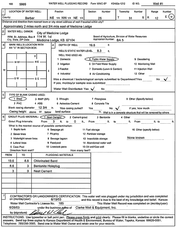
T31S, R12W, Sec. 25 NE NW NE |
City of Medicine Lodge | 19.6 ft. | 8.3 ft. | Public Water Supply | Well 1 | Plugged | 19-Jun-2003 | Scan | |
|
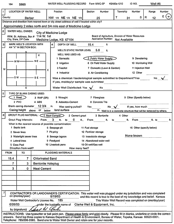
T31S, R12W, Sec. 25 NW NE NE |
City of Medicine Lodge | 15.4 ft. | 5.6 ft. | Public Water Supply | Well 5 | Plugged | 19-Jun-2003 | Scan | |
|
T31S, R12W, Sec. 25 NW NE NE |
City of Medicine Lodge | 28 ft. | 5.25 ft. | Public Water Supply | Well 5 replacement | Constructed | 18-Jul-1986 | ||
|
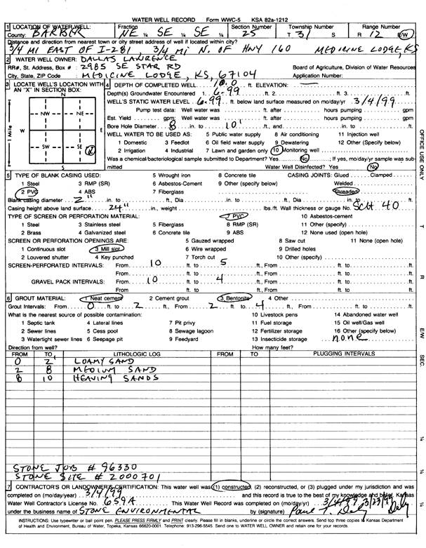
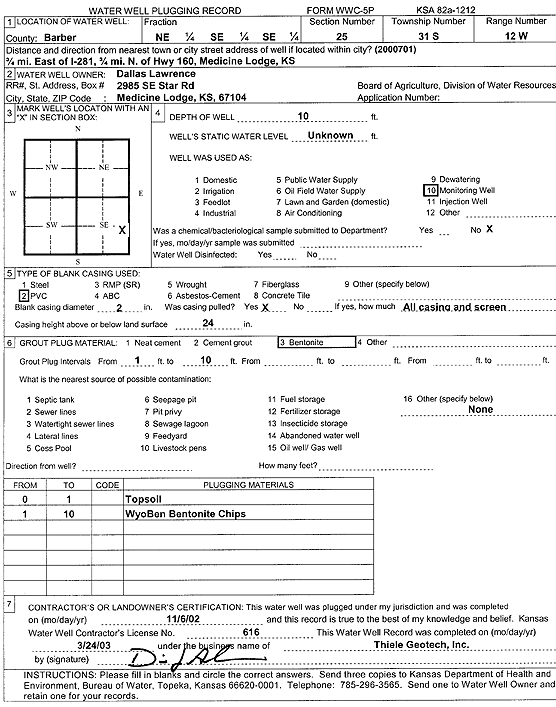
T31S, R12W, Sec. 25 NE SE SE |
Lawrence, Dallas | 10 ft. | 6.99 ft. | Monitoring well/observation/piezometer | Constructed | 04-Mar-1999 | Scan | ||
|
T31S, R12W, Sec. 25 NE SE SE |
Lawrence, Dallas | 10 ft. | Monitoring well/observation/piezometer | Plugged | 06-Nov-2002 | Scan | |||
|
T31S, R12W, Sec. 25 SW SW NW |
Rider, Joyce | 154 ft. | 32 ft. | 4 gpm. | Domestic | Constructed | 06-Nov-1992 | ||
|
T31S, R12W, Sec. 25 NE NE NW NW |
Southern Pioneer Electric | 200 ft. | Geothermal, Closed Loop, Vertical | Constructed | 30-Jun-2015 |
KOLAR |
|||
|
T31S, R12W, Sec. 27 NE NE NE |
Strickland, Fred | 43 ft. | 22 ft. | 20 gpm. | Domestic | Constructed | 03-Jun-1976 | ||
|
T31S, R12W, Sec. 29 NE SE SW |
Frieden, Clarence | 42 ft. | 9 ft. | Domestic | Constructed | 11-Dec-1987 | |||
|
T31S, R12W, Sec. 29 SE NW SE |
Gress and Dawson | 38 ft. | 12 ft. | 10 gpm. | Domestic | Constructed | 03-Jun-1983 | ||
|
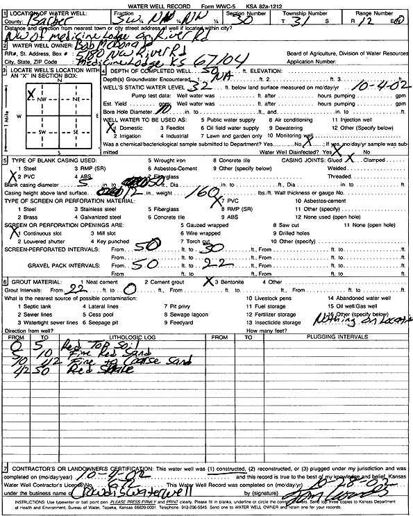
T31S, R12W, Sec. 30 SW NW NW |
McDonald, Bob | 50 ft. | 32 ft. | Domestic | Constructed | 04-Oct-2002 | Scan | ||
|
T31S, R12W, Sec. 30 SW NW SE |
McDonald, Luke | 95 ft. | 44 ft. | Domestic | Constructed | 06-May-2013 | |||
|
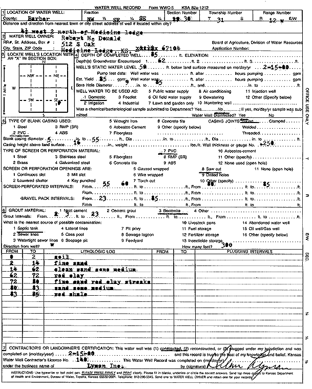
T31S, R12W, Sec. 30 NW SE SE |
McDonald, Robert | 85 ft. | 50 ft. | 25 gpm. | Domestic | Constructed | 15-Feb-2000 | Scan | |
|
T31S, R12W, Sec. 31 SE SE |
Bedwell, Tom | 64 ft. | 6.5 ft. | Test Hole, Uncased | 1 | Constructed | 02-Aug-1971 | ||
|
T31S, R12W, Sec. 31 SE SE |
Bedwell, Tom | 62 ft. | 6.5 ft. | Test Hole, Uncased | 7 | Constructed | 02-Aug-1971 | ||
|
T31S, R12W, Sec. 31 SE SE |
Bedwell, Tom | 63 ft. | 7.5 ft. | Test Hole, Uncased | 2 | Constructed | 02-Aug-1971 | ||
|
T31S, R12W, Sec. 31 SE SE |
Bedwell, Tom | 66 ft. | 9.25 ft. | Test Hole, Uncased | 3 | Constructed | 02-Aug-1971 | ||
|
T31S, R12W, Sec. 31 SE SE |
Bedwell, Tom | 68 ft. | 12 ft. | Test Hole, Uncased | 4 | Constructed | 02-Aug-1971 | ||
|
T31S, R12W, Sec. 31 SE SE |
Bedwell, Tom | 68 ft. | 13 ft. | Test Hole, Uncased | 5 | Constructed | 02-Aug-1971 | ||
|
T31S, R12W, Sec. 31 SE SE |
Bedwell, Tom | 63 ft. | 11 ft. | Test Hole, Uncased | 6 | Constructed | 02-Aug-1971 | ||
|
T31S, R12W, Sec. 31 SE SE |
Bedwell, Tom | 63 ft. | 7 ft. | Test Hole, Uncased | 8 | Constructed | 02-Aug-1971 | ||
|
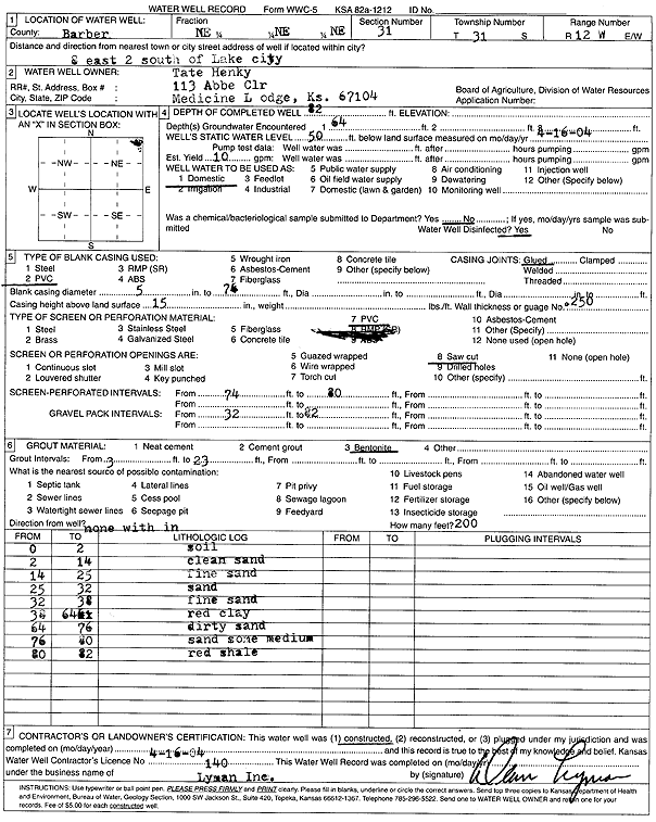
T31S, R12W, Sec. 31 NE NE NE |
Henky, Tate | 82 ft. | 50 ft. | 10 gpm. | Domestic | Constructed | 16-Apr-2004 | Scan | |
|
T31S, R12W, Sec. 31 NE NE NE |
Raleigh, Richard | 44 ft. | 30 ft. | 15 gpm. | Domestic | Constructed | 17-Jul-2007 | ||
|
T31S, R12W, Sec. 31 SE SE SE |
Simpson, Roger | 60 ft. | 10 ft. | 20 gpm. | Domestic, Livestock | Constructed | 18-May-1978 | ||
| View page: < Prev || 11 || 12 || 13 || 14 || 15 || 16 || 17 || 18 || 19 || 20 || Next > | |||||||||