Select location of well to view details.
Click on column heading to sort.
|
|
|
County: Barber Select location of well to view details. Click on column heading to sort. |
|
|
|
| View page: < Prev || 21 || 22 || 23 || 24 || 25 || 26 || 27 || 28 || 29 || 30 || Next > | |||||||||
| T-R-S | Owner | Well Depth Ascend. Desc. |
Static Water Level Ascend. Desc. |
Est. Yield Ascend. Desc. |
Well Use | Other ID | Action Taken | Completion Date Ascend. Desc. |
Scan? |
|
T32S, R12W, Sec. 11 SE NE NE |
Crescent Oil Co. | 20 ft. | 17.35 ft. | Monitoring well/observation/piezometer | MW 2 | Plugged | 08-Apr-2024 |
KOLAR |
|
|
T32S, R12W, Sec. 11 SE NE NE |
Crescent Oil Co. | 23 ft. | Monitoring well/observation/piezometer | MW 9 | Constructed | 24-Apr-2008 | |||
|
T32S, R12W, Sec. 11 NW NE NE |
Farmers Co-op Exchange | 95 ft. | 27 ft. | 5 gpm. | Monitoring well/observation/piezometer | Constructed | 23-Jul-2013 | ||
|
T32S, R12W, Sec. 11 NW NE NW |
Fortune, Ray | 32 ft. | 9 ft. | 10 gpm. | Domestic | Constructed | 14-Apr-1981 | ||
|
T32S, R12W, Sec. 11 C SW |
Garten, Frank/Graves Drilling Co. | 35 ft. | 20 ft. | 60 gpm. | Oil Field Water Supply | Garten 4 | Constructed | 18-Nov-1985 | |
|
T32S, R12W, Sec. 11 SE NW NE |
Graves Drilling Co., Inc. | 50 ft. | 12 ft. | 60 gpm. | Oil Field Water Supply | Constructed | 29-Dec-1981 | ||
|
T32S, R12W, Sec. 11 NE NE SW |
Graves Drilling Co., Inc. | 54 ft. | 8 ft. | 60 gpm. | Oil Field Water Supply | Constructed | 14-Nov-1981 | ||
|
T32S, R12W, Sec. 11 SW SW NE |
Graves Drilling Co., Inc. | 44 ft. | 4 ft. | 60 gpm. | Oil Field Water Supply | Constructed | 02-Feb-1982 | ||
|
T32S, R12W, Sec. 11 E2 W2 NW |
Graves Drilling Co., Inc. | 50 ft. | 8 ft. | 60 gpm. | Oil Field Water Supply | Constructed | 04-May-1981 | ||
|
T32S, R12W, Sec. 11 C N2 NW SE |
Graves Drilling Co., Inc. | 26 ft. | 5 ft. | 60 gpm. | Oil Field Water Supply | Constructed | 26-Aug-1981 | ||
|
T32S, R12W, Sec. 11 SE SE NE |
Graves Drilling Co., Inc. | 35 ft. | 6 ft. | 60 gpm. | Oil Field Water Supply | Constructed | 07-Aug-1981 | ||
|
T32S, R12W, Sec. 11 C NW NW |
Graves Drilling Co., Inc. | 40 ft. | 7 ft. | 60 gpm. | Oil Field Water Supply | Constructed | 17-Feb-1981 | ||
|
T32S, R12W, Sec. 11 NE NE SW |
Graves Drilling Co., Inc. | 45 ft. | 7 ft. | Oil Field Water Supply | Constructed | 03-Sep-1992 | |||
|
T32S, R12W, Sec. 11 SE NE NE |
High Sierra | 80 ft. | 22 ft. | Oil Field Water Supply | Constructed | 08-Oct-2010 | |||
|
T32S, R12W, Sec. 11 SW SW NE |
Kansas Dept. of Transportation | 59.5 ft. | 13.5 ft. | 10 gpm. | Public Water Supply | Constructed | 02-Mar-1977 | ||
|
T32S, R12W, Sec. 11 SW SW NE |
Krable, Ferren/Graves Drilling Co. | 40 ft. | 3 ft. | 60 gpm. | Oil Field Water Supply | Smith | Constructed | 22-Jun-1992 | |
|
T32S, R12W, Sec. 11 C NE NW |
Krehbiel, Theron/Graves Drilling Co. | 50 ft. | 5 ft. | Oil Field Water Supply | Theron 5 | Plugged | 06-Mar-1986 | ||
|
T32S, R12W, Sec. 11 SW SW NE |
Krehbiel, Theron/Graves Drilling Co. | 50 ft. | 5 ft. | Oil Field Water Supply | Smith 3 | Plugged | 06-Mar-1986 | ||
|
T32S, R12W, Sec. 11 C N2 NW SE |
Krehbiel, Theron/Graves Drilling Co. | 50 ft. | 5 ft. | Oil Field Water Supply | Smith B 5 | Plugged | 06-Mar-1986 | ||
|
T32S, R12W, Sec. 11 SE SE SW |
Sears, Paul | 33 ft. | 6 ft. | 25 gpm. | Domestic | Constructed | 29-Sep-1982 | ||
|
T32S, R12W, Sec. 11 SE SE SW |
Sears, Paul | 40 ft. | 10 ft. | 400 gpm. | Industrial | Constructed | 22-Oct-1981 | ||
|
T32S, R12W, Sec. 11 SE SW NW |
Sears, Paul | 35 ft. | 4 ft. | 30 gpm. | Domestic | Constructed | 04-Apr-1984 | ||
|
T32S, R12W, Sec. 11 NE NW NE |
Southern Wellpoint Co., Inc. | 25 ft. | Dewatering | Constructed | 12-Mar-1982 | ||||
|
T32S, R12W, Sec. 11 NE NW NE |
Southern Wellpoint Co., Inc. | 13 ft. | Dewatering | Constructed | 12-Mar-1982 | ||||
|
T32S, R12W, Sec. 11 NE NE |
Strong, Richard | 46 ft. | 12 ft. | 10 gpm. | Domestic | Constructed | 03-May-2003 | Scan | |
|
T32S, R12W, Sec. 11 C NE NW |
Theran, Frank/Graves Drilling Co. | 28 ft. | 3 ft. | 60 gpm. | Oil Field Water Supply | Theran 3 | Constructed | 28-Nov-1984 | |
|
T32S, R12W, Sec. 11 SW NE NW |
Wheelock Ranch | 30 ft. | 4 ft. | 50 gpm. | Domestic, Livestock | Constructed | 01-Feb-2024 | ||
|
T32S, R12W, Sec. 12 SW NW SW |
Bailey, Bill | 50 ft. | 4 ft. | 15 gpm. | Domestic | Constructed | 13-Apr-1988 | ||
|
T32S, R12W, Sec. 12 NE NW NW SW |
Brandon, Boor | 46 ft. | 17 ft. | 7 gpm. | Domestic, Lawn and Garden | Constructed | 06-Apr-2015 |
KOLAR |
|
|
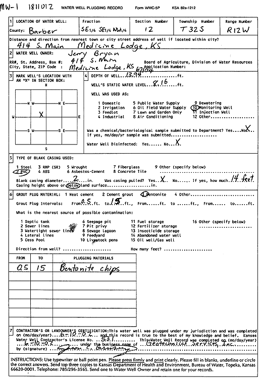
T32S, R12W, Sec. 12 SE SE NW |
Bryan, Jerry | 13.94 ft. | 8.16 ft. | Monitoring well/observation/piezometer | MW 1 | Plugged | 10-Jun-2002 | Scan | |
|
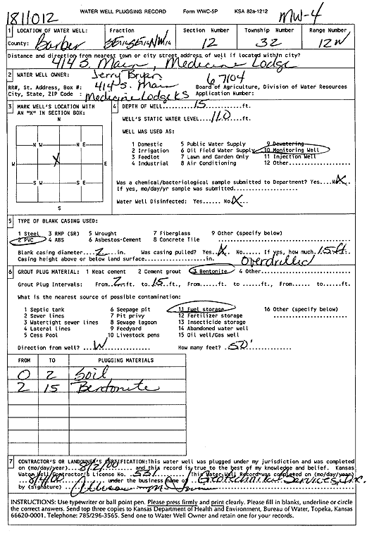
T32S, R12W, Sec. 12 SE SE NW |
Bryan, Jerry | 15 ft. | 11 ft. | Monitoring well/observation/piezometer | MW 4 | Plugged | 02-Aug-2000 | Scan | |
|
T32S, R12W, Sec. 12 SE SE NW |
Bryan, Jerry | 16 ft. | 6.29 ft. | Monitoring well/observation/piezometer | MW 5 | Reconstructed | 31-May-1995 | ||
|
T32S, R12W, Sec. 12 SE SE NW |
Bryan, Jerry | 10 ft. | Test hole/well | BH 4 | Plugged | 30-Apr-1991 | |||
|
T32S, R12W, Sec. 12 SE SE NW |
Bryan, Jerry | 10 ft. | Test hole/well | BH 3 | Plugged | 29-Apr-1991 | |||
|
T32S, R12W, Sec. 12 SE SE NW |
Bryan, Jerry | 10 ft. | Test hole/well | BH 1 | Plugged | 29-Apr-1992 | |||
|
T32S, R12W, Sec. 12 SE SE NW |
Bryan, Jerry | 15 ft. | 8.31 ft. | Monitoring well/observation/piezometer | MW 3 | Constructed | 30-Apr-1991 | ||
|
T32S, R12W, Sec. 12 SE SE NW |
Bryan, Jerry | 15 ft. | 7.87 ft. | Monitoring well/observation/piezometer | MW 1 - BH 2 | Constructed | 29-Apr-1991 | ||
|
T32S, R12W, Sec. 12 SE SE NW |
Bryan, Jerry | 15 ft. | 6.8 ft. | Monitoring well/observation/piezometer | MW 6 | Constructed | 30-Apr-1991 | ||
|
T32S, R12W, Sec. 12 SE SE NW |
Bryan, Jerry | 15 ft. | Monitoring well/observation/piezometer | MW 7 | Constructed | 04-May-1992 | |||
|
T32S, R12W, Sec. 12 SE SE NW |
Bryan, Jerry | 15 ft. | 8.44 ft. | Monitoring well/observation/piezometer | MW 2 | Constructed | 30-Apr-1991 | ||
|
T32S, R12W, Sec. 12 SE SE NW |
Bryan, Jerry | 15 ft. | 9.4 ft. | Monitoring well/observation/piezometer | MW 4 | Constructed | 30-Apr-1991 | ||
|
T32S, R12W, Sec. 12 SE SE NW |
Bryan, Jerry | 18 ft. | 10.93 ft. | Monitoring well/observation/piezometer | MW 5 | Constructed | 30-Apr-1991 | ||
|
T32S, R12W, Sec. 12 SE SE NW |
Bryan, Jerry | 14.5 ft. | Monitoring well/observation/piezometer | MW 1 R | Constructed | 08-Jun-2004 | |||
|
T32S, R12W, Sec. 12 NE NE NW |
Bryan, Jerry | 20.4 ft. | Monitoring well/observation/piezometer | MW 5R | Constructed | 08-Jun-2004 | |||
|
T32S, R12W, Sec. 12 NE NE SW |
Bryan, Jerry | 14 ft. | Monitoring well/observation/piezometer | MW 6R | Constructed | 08-Jun-2004 | |||
|
T32S, R12W, Sec. 12 NE NE SW |
Bryan, Jerry | 14 ft. | Monitoring well/observation/piezometer | MW 7R | Constructed | 08-Jun-2004 | |||
|
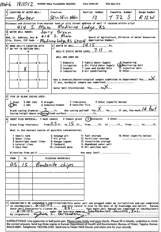
T32S, R12W, Sec. 12 SE SE NW |
Bryan, Jerry | 14.15 ft. | 7.11 ft. | Monitoring well/observation/piezometer | MW 6 | Plugged | 10-Jun-2002 | Scan | |
|
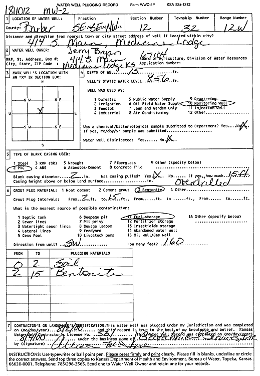
T32S, R12W, Sec. 12 SE SE NW |
Bryan, Jerry | 15 ft. | 8.56 ft. | Monitoring well/observation/piezometer | MW 2 | Plugged | 02-Aug-2000 | Scan | |
|
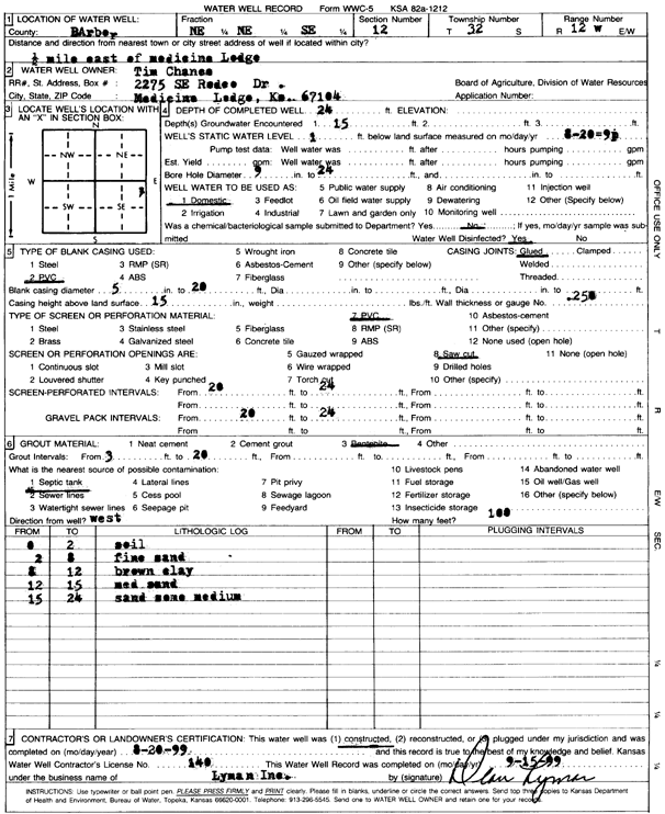
T32S, R12W, Sec. 12 NE NE SE |
Chance, Tim | 25 ft. | 1 ft. | Domestic | Constructed | 20-Aug-1999 | Scan | ||
|
T32S, R12W, Sec. 12 NE NE SW |
City of Medicine Lodge | 15.3 ft. | 7.52 ft. | Monitoring well/observation/piezometer | MW 2 | Constructed | 13-Jun-1994 | ||
| View page: < Prev || 21 || 22 || 23 || 24 || 25 || 26 || 27 || 28 || 29 || 30 || Next > | |||||||||