Select location of well to view details.
Click on column heading to sort.
|
|
|
County: Barber Select location of well to view details. Click on column heading to sort. |
|
|
|
| View page: < Prev || 21 || 22 || 23 || 24 || 25 || 26 || 27 || 28 || 29 || 30 || Next > | |||||||||
| T-R-S | Owner | Well Depth Ascend. Desc. |
Static Water Level Ascend. Desc. |
Est. Yield Ascend. Desc. |
Well Use | Other ID | Action Taken | Completion Date Ascend. Desc. |
Scan? |
|
T32S, R12W, Sec. 12 NW NE SW |
City of Medicine Lodge | 15.3 ft. | 10.11 ft. | Monitoring well/observation/piezometer | MW 5 | Constructed | 14-Jun-1994 | ||
|
T32S, R12W, Sec. 12 SE NE SW |
City of Medicine Lodge | 15.3 ft. | 4.8 ft. | Monitoring well/observation/piezometer | MW 8 | Constructed | 13-Jun-1994 | ||
|
T32S, R12W, Sec. 12 NE NE SW |
Clarke Corp. | 15.3 ft. | 7.15 ft. | Monitoring well/observation/piezometer | MW 1 | Constructed | 13-Jun-1994 | ||
|
T32S, R12W, Sec. 12 NW NE SW |
Clarke Corp. | 15.3 ft. | 8.62 ft. | Monitoring well/observation/piezometer | MW 3 | Constructed | 14-Jun-1994 | ||
|
T32S, R12W, Sec. 12 NE NE SW |
Clarke Corp. | 15.3 ft. | 4.31 ft. | Monitoring well/observation/piezometer | MW 7 | Constructed | 14-Jun-1994 | ||
|
T32S, R12W, Sec. 12 NE NE SW |
Clarke Corp. | 15.3 ft. | 8.6 ft. | Monitoring well/observation/piezometer | MW 6 | Constructed | 13-Jun-1994 | ||
|
T32S, R12W, Sec. 12 SE NE SW |
Clarke Corp. | 15.3 ft. | 6.63 ft. | Monitoring well/observation/piezometer | MW 9 | Constructed | 13-Jun-1994 | ||
|
T32S, R12W, Sec. 12 NE NE SW |
Dick, Larry | 15.3 ft. | 4.5 ft. | Monitoring well/observation/piezometer | MW 4 | Constructed | 14-Jun-1994 | ||
|
T32S, R12W, Sec. 12 SW SW NW |
Domino Food and Fuel 3/Elmer Smith Oil Co | 14.7 ft. | 9.5 ft. | Monitoring well/observation/piezometer | Domino MW 2 | Plugged | 25-Jul-2005 | ||
|
T32S, R12W, Sec. 12 SW SW NW |
Domino Food and Fuel 3/Elmer Smith Oil Co | 15 ft. | 10.8 ft. | Monitoring well/observation/piezometer | Domino MW 4 | Plugged | 25-Jul-2005 | ||
|
T32S, R12W, Sec. 12 SW SW NW |
Domino Food and Fuel 3/Elmer Smith Oil Co | 14.2 ft. | 10.6 ft. | Monitoring well/observation/piezometer | Domino MW 5 | Plugged | 25-Jul-2005 | ||
|
T32S, R12W, Sec. 12 SW SW NW |
Domino Food and Fuel 3/Elmer Smith Oil Co | 17 ft. | 10.65 ft. | Monitoring well/observation/piezometer | Domino MW 1 | Plugged | 25-Jul-2005 | ||
|
T32S, R12W, Sec. 12 SW SW NW |
Domino Food and Fuel 3/Elmer Smith Oil Co | 14.3 ft. | 9.3 ft. | Monitoring well/observation/piezometer | Domino MW 3 | Plugged | 25-Jul-2005 | ||
|
T32S, R12W, Sec. 12 SW SW NW |
Elmer Smith Oil Co. | 12.5 ft. | 6.8 ft. | Monitoring well/observation/piezometer | MW 6 | Constructed | 18-Aug-1995 | ||
|
T32S, R12W, Sec. 12 SW SW NW |
Elmer Smith Oil Co. | 14 ft. | 6.75 ft. | Monitoring well/observation/piezometer | MW 3 | Constructed | 18-Aug-1995 | ||
|
T32S, R12W, Sec. 12 SW SW NW |
Elmer Smith Oil Co. | 12.5 ft. | 7 ft. | Monitoring well/observation/piezometer | MW 2 | Constructed | 18-Aug-1995 | ||
|
T32S, R12W, Sec. 12 SW SW NW |
Elmer Smith Oil Co. | 12.5 ft. | 6.65 ft. | Monitoring well/observation/piezometer | MW 1 | Constructed | 18-Aug-1995 | ||
|
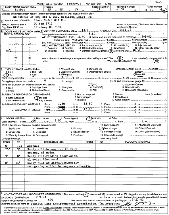
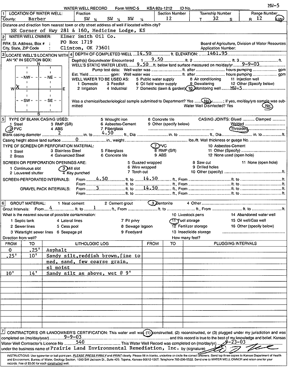
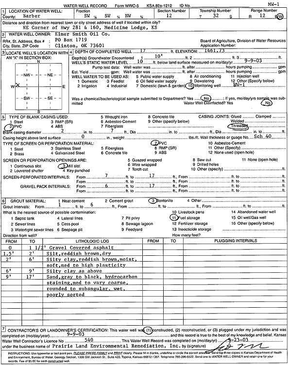
T32S, R12W, Sec. 12 SW SW NW |
Elmer Smith Oil Co. | 13.8 ft. | 8.8 ft. | Monitoring well/observation/piezometer | Domino MW 3 | Constructed | 09-Sep-2003 | Scan | |
|
T32S, R12W, Sec. 12 SW SW NW |
Elmer Smith Oil Co. | 12.5 ft. | 5.28 ft. | Monitoring well/observation/piezometer | MW 4 | Constructed | 18-Aug-1995 | ||
|
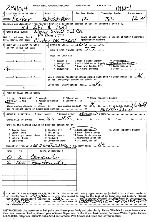
T32S, R12W, Sec. 12 SW SW NW |
Elmer Smith Oil Co. | 12.5 ft. | 7.7 ft. | Monitoring well/observation/piezometer | MW 1 | Plugged | 03-May-2000 | Scan | |
|
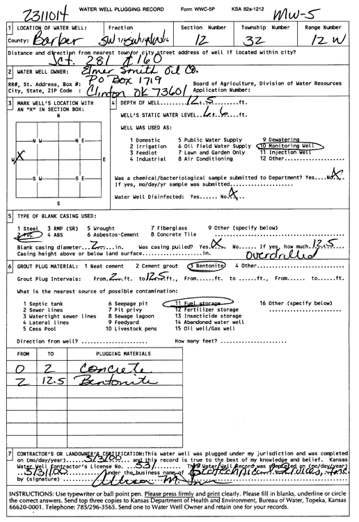
T32S, R12W, Sec. 12 SW SW NW |
Elmer Smith Oil Co. | 12.5 ft. | 6.6 ft. | Monitoring well/observation/piezometer | MW 5 | Plugged | 03-May-2000 | Scan | |
|
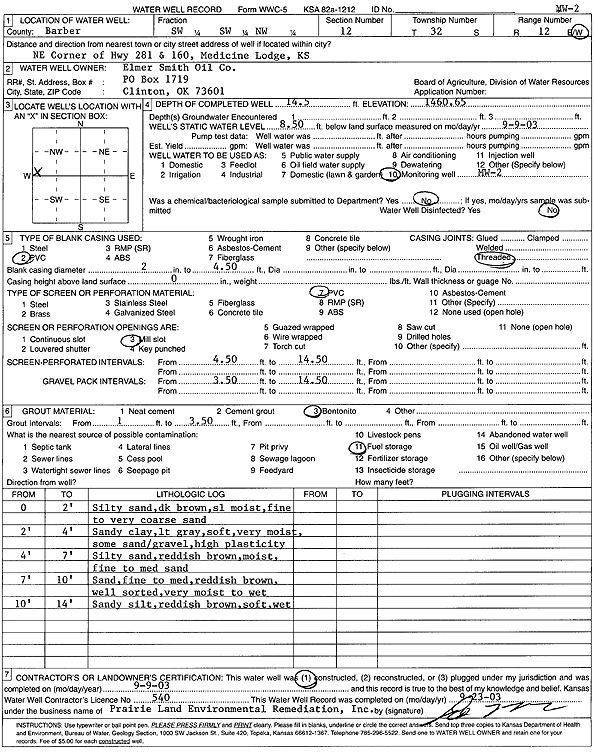
T32S, R12W, Sec. 12 SW SW NW |
Elmer Smith Oil Co. | 14.5 ft. | 8.5 ft. | Monitoring well/observation/piezometer | Domino MW 2 | Constructed | 09-Sep-2003 | Scan | |
|
T32S, R12W, Sec. 12 SW SW NW |
Elmer Smith Oil Co. | 12.5 ft. | 6.62 ft. | Monitoring well/observation/piezometer | MW 5 | Constructed | 18-Aug-1995 | ||
|
T32S, R12W, Sec. 12 SW SW NW |
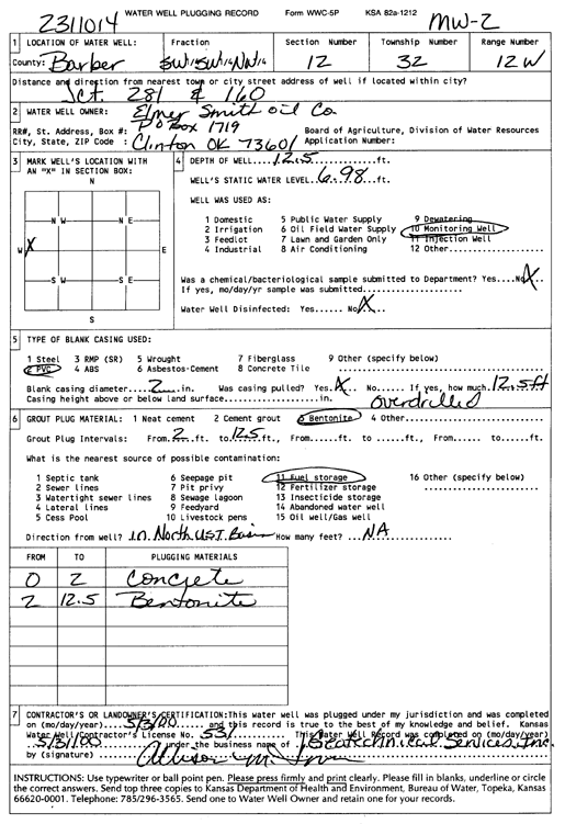
Elmer Smith Oil Co. | 12.5 ft. | 6.98 ft. | Monitoring well/observation/piezometer | MW 2 | Plugged | 03-May-2000 | Scan | |
|
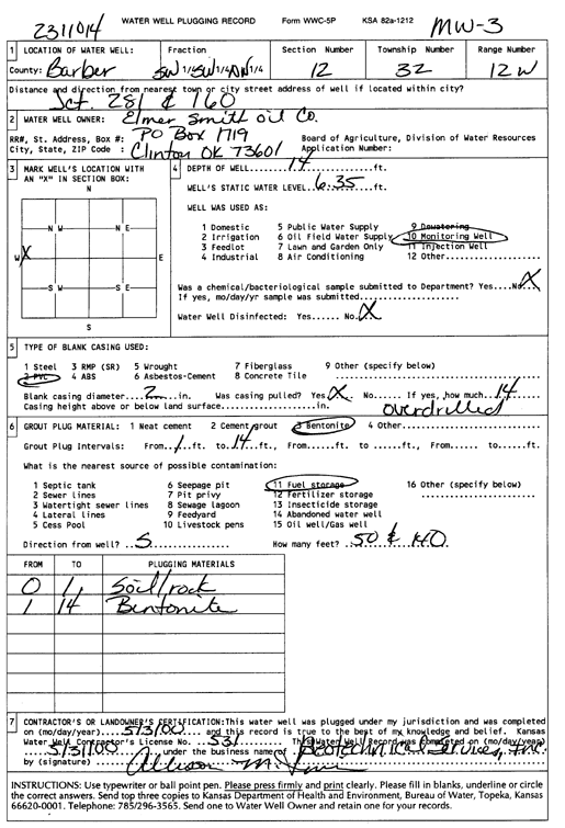
T32S, R12W, Sec. 12 SW SW NW |
Elmer Smith Oil Co. | 14 ft. | 6.35 ft. | Monitoring well/observation/piezometer | MW 3 | Plugged | 03-May-2000 | Scan | |
|
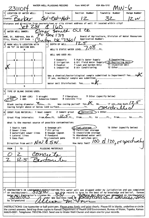
T32S, R12W, Sec. 12 SW SW NW |
Elmer Smith Oil Co. | 12.5 ft. | 7.08 ft. | Monitoring well/observation/piezometer | MW 6 | Plugged | 03-May-2000 | Scan | |
|
T32S, R12W, Sec. 12 SW SW NW |
Elmer Smith Oil Co. | 15 ft. | 10 ft. | Monitoring well/observation/piezometer | Domino MW 4 | Constructed | 09-Sep-2003 | Scan | |
|
T32S, R12W, Sec. 12 SW SW NW |
Elmer Smith Oil Co. | 14.5 ft. | 9.5 ft. | Monitoring well/observation/piezometer | Domino MW 5 | Constructed | 09-Sep-2003 | Scan | |
|
T32S, R12W, Sec. 12 SW SW NW |
Elmer Smith Oil Co. | 17 ft. | 10 ft. | Monitoring well/observation/piezometer | Domino MW 1 | Constructed | 09-Sep-2003 | Scan | |
|
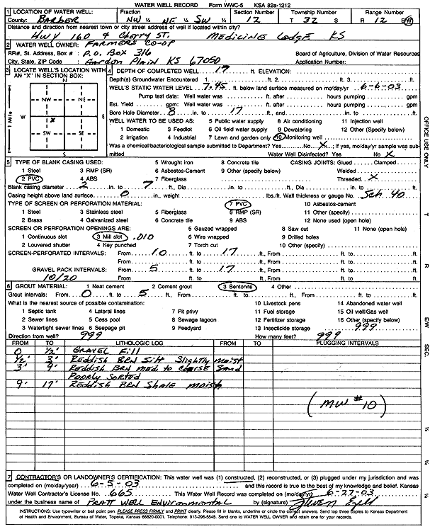
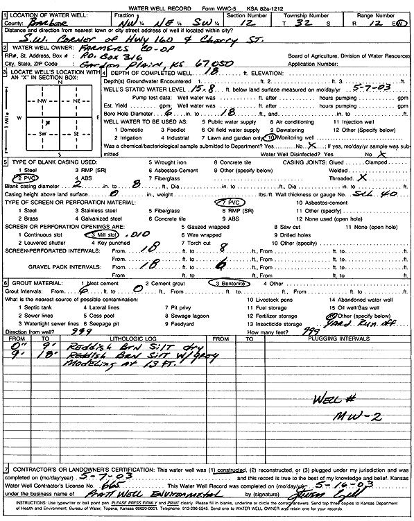
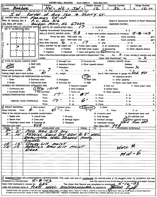
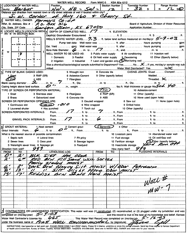
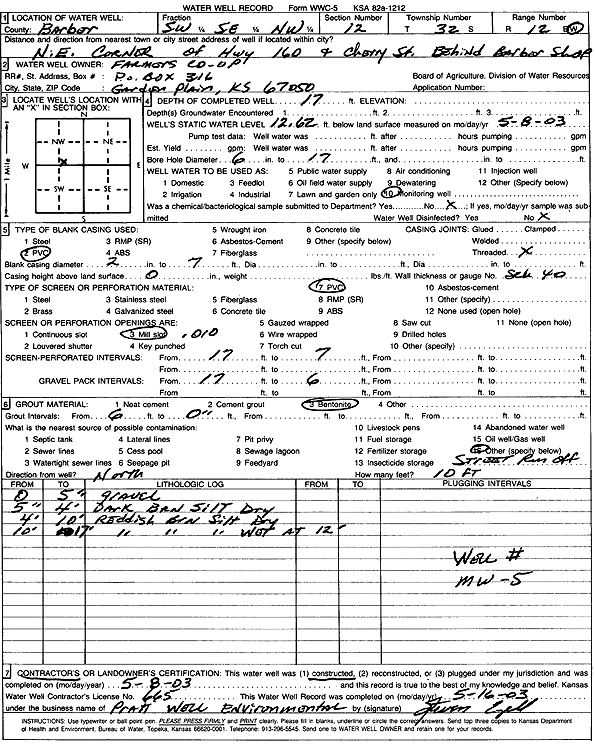
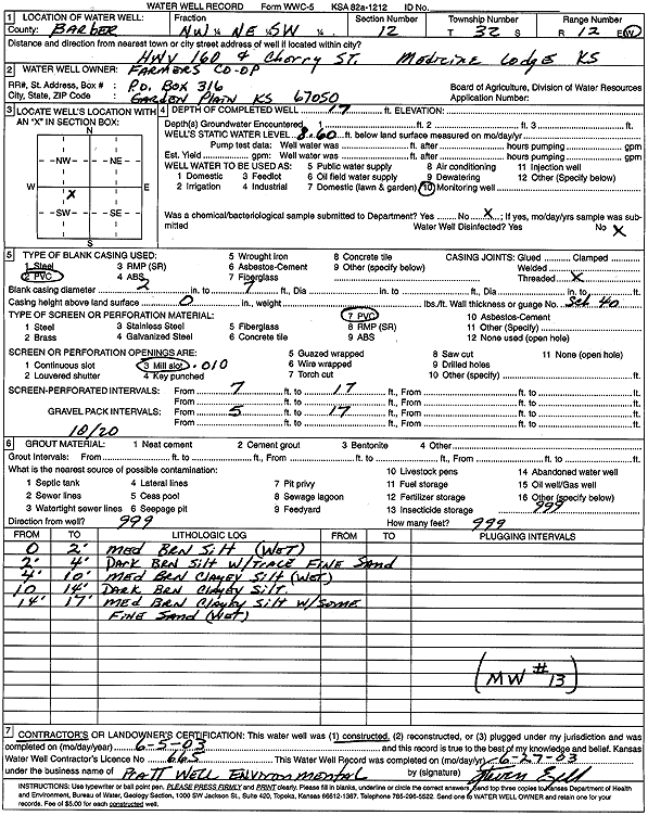
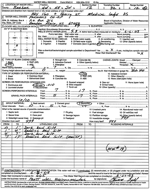
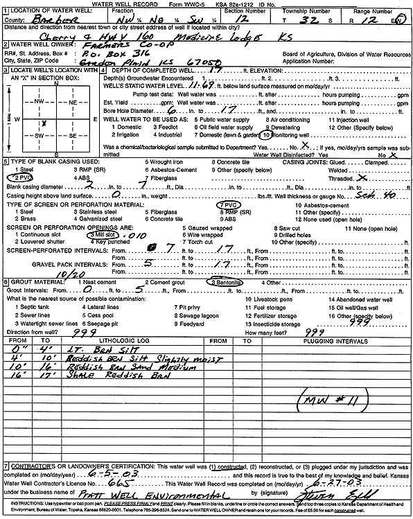
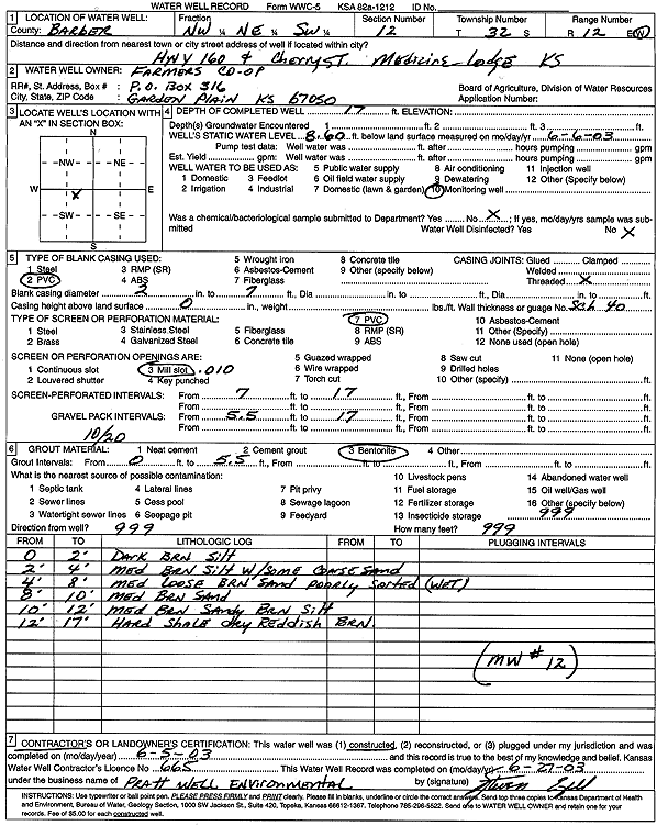
T32S, R12W, Sec. 12 NW NE SW |
Farmers Co-op | 17 ft. | 7.45 ft. | Monitoring well/observation/piezometer | MW 10 | Constructed | 05-Jun-2003 | Scan | |
|
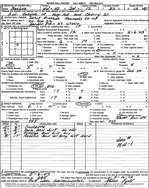
T32S, R12W, Sec. 12 NW NE SW |
Farmers Co-op | 17 ft. | 15.64 ft. | Monitoring well/observation/piezometer | MW 3 | Constructed | 08-May-2003 | Scan | |
|
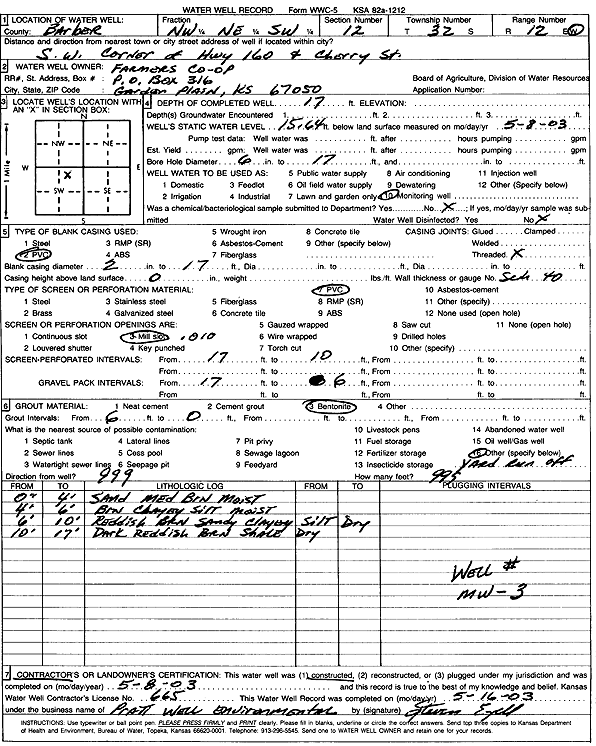
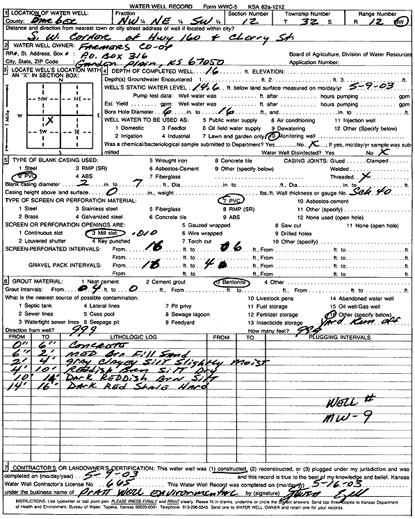
T32S, R12W, Sec. 12 NW NE SW |
Farmers Co-op | 16 ft. | 14.6 ft. | Monitoring well/observation/piezometer | MW 9 | Constructed | 09-May-2003 | Scan | |
|
T32S, R12W, Sec. 12 NW NE SW |
Farmers Co-op | 18 ft. | 15.8 ft. | Monitoring well/observation/piezometer | MW 2 | Constructed | 07-May-2003 | Scan | |
|
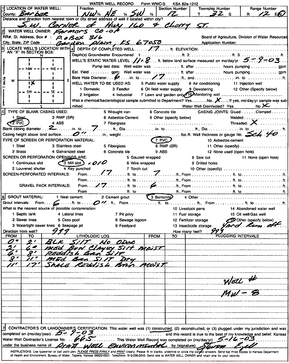
T32S, R12W, Sec. 12 NW NE SW |
Farmers Co-op | 17 ft. | 7.8 ft. | Monitoring well/observation/piezometer | MW 6 | Constructed | 08-May-2003 | Scan | |
|
T32S, R12W, Sec. 12 NW NE SW |
Farmers Co-op | 17 ft. | 7.3 ft. | Monitoring well/observation/piezometer | MW 7 | Constructed | 09-May-2003 | Scan | |
|
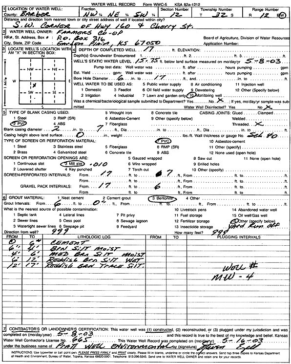
T32S, R12W, Sec. 12 SW SE NW |
Farmers Co-op | 17 ft. | 12.62 ft. | Monitoring well/observation/piezometer | MW 5 | Constructed | 08-May-2003 | Scan | |
|
T32S, R12W, Sec. 12 NW NE SW |
Farmers Co-op | 17 ft. | 8.6 ft. | Monitoring well/observation/piezometer | MW 13 | Constructed | 05-Jun-2003 | Scan | |
|
T32S, R12W, Sec. 12 NW NE SW |
Farmers Co-op | 17 ft. | 12 ft. | Monitoring well/observation/piezometer | MW 1 | Constructed | 06-May-2003 | Scan | |
|
T32S, R12W, Sec. 12 NW NE SW |
Farmers Co-op | 17 ft. | 15.75 ft. | Monitoring well/observation/piezometer | MW 4 | Constructed | 08-May-2003 | Scan | |
|
T32S, R12W, Sec. 12 NW NE SW |
Farmers Co-op | 17 ft. | 11.8 ft. | Monitoring well/observation/piezometer | MW 8 | Constructed | 09-May-2003 | Scan | |
|
T32S, R12W, Sec. 12 NW NE SW |
Farmers Co-op | 17 ft. | 9.8 ft. | Monitoring well/observation/piezometer | MW 14 | Constructed | 05-Jun-2003 | Scan | |
|
T32S, R12W, Sec. 12 NW NE SW |
Farmers Co-op | 17 ft. | 11.69 ft. | Monitoring well/observation/piezometer | MW 11 | Constructed | 05-Jun-2003 | Scan | |
|
T32S, R12W, Sec. 12 NW NE SW |
Farmers Co-op | 17 ft. | 8.6 ft. | Monitoring well/observation/piezometer | MW 12 | Constructed | 05-Jun-2003 | Scan | |
|
T32S, R12W, Sec. 12 SW NE SE NW |
Former FFP 671 | 23.89 ft. | 17.98 ft. | Monitoring well/observation/piezometer | MW 2 | Plugged | 16-Nov-2011 | ||
|
T32S, R12W, Sec. 12 SW NE SE NW |
Former FFP 671 | 25 ft. | 19.02 ft. | Monitoring well/observation/piezometer | MW 4 | Constructed | 08-Dec-2009 | ||
|
T32S, R12W, Sec. 12 SW NE SE NW |
Former FFP 671 | 22 ft. | 14.89 ft. | Monitoring well/observation/piezometer | MW 6 | Constructed | 08-Dec-2009 | ||
|
T32S, R12W, Sec. 12 SW NE SE NW |
Former FFP 671 | 25 ft. | 17.41 ft. | Monitoring well/observation/piezometer | MW 3 | Constructed | 19-Nov-2009 | ||
|
T32S, R12W, Sec. 12 SW NE SE NW |
Former FFP 671 | 25 ft. | 17.31 ft. | Monitoring well/observation/piezometer | MW 2 | Constructed | 19-Nov-2009 | ||
|
T32S, R12W, Sec. 12 SW NE SE NW |
Former FFP 671 | 25 ft. | 20.45 ft. | Monitoring well/observation/piezometer | MW 5 | Constructed | 08-Dec-2009 | ||
|
T32S, R12W, Sec. 12 SW NE SE NW |
Former FFP 671 | 24.55 ft. | 19.51 ft. | Monitoring well/observation/piezometer | MW 4 | Plugged | 16-Nov-2011 | ||
| View page: < Prev || 21 || 22 || 23 || 24 || 25 || 26 || 27 || 28 || 29 || 30 || Next > | |||||||||