Select location of well to view details.
Click on column heading to sort.
|
|
|
County: Haskell Select location of well to view details. Click on column heading to sort. |
|
|
|
| View page: < Prev || 21 || 22 || 23 || 24 || 25 || 26 || 27 || 28 || 29 || 30 || Next > | |||||||||
| T-R-S | Owner | Well Depth Ascend. Desc. |
Static Water Level Ascend. Desc. |
Est. Yield Ascend. Desc. |
Well Use | Other ID | Action Taken | Completion Date Ascend. Desc. |
Scan? |
|
T29S, R32W, Sec. 31 NW NW NW |
SW Windmill/Guenther, Isaac | 460 ft. | 340 ft. | Domestic | Constructed | 04-Aug-2008 | |||
|
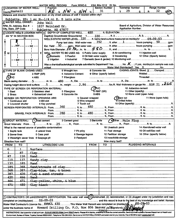
T29S, R32W, Sec. 31 NE NW NW |
Wall, John | 480 ft. | 330 ft. | 50 gpm. | Domestic | Constructed | 09-Aug-2003 | Scan | |
|
T29S, R32W, Sec. 31 NW NW NW NE |
Webber, C. H. | 705 ft. | 386 ft. | 500 gpm. | Irrigation | Constructed | 16-Feb-2022 |
KOLAR |
|
|
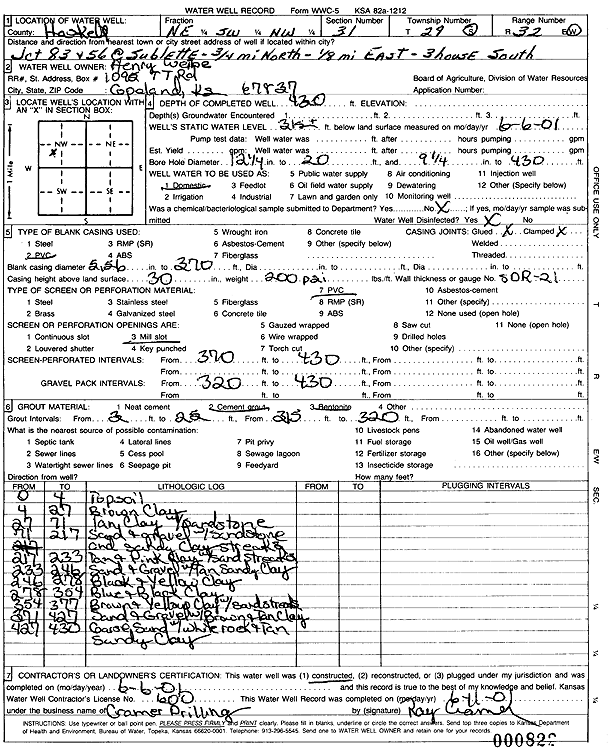
T29S, R32W, Sec. 31 NE SW NW |
Weibe, Henry | 430 ft. | 315 ft. | Domestic | Constructed | 06-Jun-2001 | Scan | ||
|
T29S, R32W, Sec. 32 NW NW NE |
City of Sublette | 403 ft. | Public Water Supply | Plugged | 15-Mar-2012 | ||||
|
T29S, R32W, Sec. 32 SE SE SE |
City of Sublette | 451 ft. | 315 ft. | Public Water Supply | Constructed | 01-Oct-1998 | |||
|
T29S, R32W, Sec. 32 SW NW NW |
City of Sublette | 705 ft. | 346 ft. | 50 gpm. | Monitoring well/observation/piezometer | Constructed | 05-Nov-2010 | ||
|
T29S, R32W, Sec. 32 SW SW NW NW |
City of Sublette | 725 ft. | 348 ft. | 517 gpm. | Public Water Supply | Morris | Constructed | 15-Dec-2012 |
KOLAR |
|
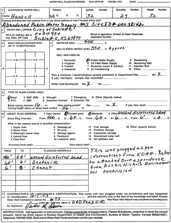
T29S, R32W, Sec. 32 SE |
City of Sublette | 400 ft. | 350 ft. | Public Water Supply | Plugged | 01-Oct-2003 | Scan | ||
|
T29S, R32W, Sec. 32 NW NE NW |
City of Sublette | 685 ft. | 255 ft. | 1300 gpm. | Public Water Supply | Constructed | 18-Oct-1977 | ||
|
T29S, R32W, Sec. 32 SW NW NE |
City of Sublette | 718 ft. | 350 ft. | Public Water Supply | Constructed | 11-Oct-2011 | |||
|
T29S, R32W, Sec. 32 SW SW SW |
Collingwood Grain ADM | 369 ft. | Monitoring well/observation/piezometer | MW 7 | Plugged | 20-Nov-2007 | |||
|
T29S, R32W, Sec. 32 SW SW SW |
Collingwood Grain ADM | 380 ft. | 369.48 ft. | Monitoring well/observation/piezometer | MW 6 | Plugged | 20-Nov-2007 | ||
|
T29S, R32W, Sec. 32 SW SW SW |
Collingwood Grain ADM | 56.94 ft. | Monitoring well/observation/piezometer | VOBW 2 | Plugged | 20-Nov-2007 | |||
|
T29S, R32W, Sec. 32 NW SW NE |
Collingwood Grain ADM | 57 ft. | Recovery/Soil Vapor Extraction/Soil Vent | VEW 1 | Plugged | 03-Aug-2004 | |||
|
T29S, R32W, Sec. 32 NW SW NE |
Collingwood Grain ADM | 127 ft. | Monitoring well/observation/piezometer | VOBW 5 | Plugged | 03-Aug-2004 | |||
|
T29S, R32W, Sec. 32 NW SW SW |
Collingwood Grain ADM | 380 ft. | Monitoring well/observation/piezometer | MW 6 | Constructed | 15-Mar-2006 | |||
|
T29S, R32W, Sec. 32 SW SW SW |
Collingwood Grain ADM | 380 ft. | 368.94 ft. | Monitoring well/observation/piezometer | MW 5 | Plugged | 20-Nov-2007 | ||
|
T29S, R32W, Sec. 32 NW SW SW |
Collingwood Grain ADM | 369 ft. | Monitoring well/observation/piezometer | MW 7 | Constructed | 10-Mar-2006 | |||
|
T29S, R32W, Sec. 32 NW SW NE |
Collingwood Grain ADM | 57 ft. | Monitoring well/observation/piezometer | VOBW 1 | Plugged | 03-Aug-2004 | |||
|
T29S, R32W, Sec. 32 NW SW NE |
Collingwood Grain ADM | 125 ft. | Monitoring well/observation/piezometer | VOBW 4 | Plugged | 03-Aug-2004 | |||
|
T29S, R32W, Sec. 32 NW SW NE |
Collingwood Grain ADM | 126 ft. | Recovery/Soil Vapor Extraction/Soil Vent | VEW 2 | Plugged | 03-Aug-2004 | |||
|
T29S, R32W, Sec. 32 NW SW NE |
Collingwood Grain ADM | 126 ft. | Monitoring well/observation/piezometer | VOBW 3 | Plugged | 03-Aug-2004 | |||
|
T29S, R32W, Sec. 32 NW SW SW |
Collingwood Grain ADM | 380 ft. | Monitoring well/observation/piezometer | MW 5 | Constructed | 10-Mar-2006 | |||
|
T29S, R32W, Sec. 32 SW SW NE |
Collingwood Grain Facility | 369 ft. | Monitoring well/observation/piezometer | MW 7 | Constructed | 06-Mar-2006 | |||
|
T29S, R32W, Sec. 32 SW SW NE |
Collingwood Grain Facility | 380 ft. | Monitoring well/observation/piezometer | MW 6 | Constructed | 13-Mar-2006 | |||
|
T29S, R32W, Sec. 32 SW SW NE |
Collingwood Grain Facility | 380 ft. | Monitoring well/observation/piezometer | MW 5 | Constructed | 08-Mar-2006 | |||
|
T29S, R32W, Sec. 32 SE SE SE NW |
Convenience Plus | 391 ft. | Monitoring well/observation/piezometer | MW 3 | Constructed | 15-Oct-2007 | |||
|
T29S, R32W, Sec. 32 SE SE SE NW |
Convenience Plus | 365 ft. | Monitoring well/observation/piezometer | MW 1 | Constructed | 22-Oct-2007 | |||
|
T29S, R32W, Sec. 32 SE SE SE NW |
Convenience Plus | 350 ft. | Monitoring well/observation/piezometer | MW 2 | Constructed | 18-Oct-2007 | |||
|
T29S, R32W, Sec. 32 SW NW SW SE |
Shotton, Brad | 240 ft. | Geothermal, Closed Loop, Vertical | Constructed | 23-Dec-2015 | ||||
|
T29S, R32W, Sec. 32 NWSWNW |
Sparke, Mrs. James | 389 ft. | 250 ft. | 40 gpm. | Domestic | Constructed | 14-Sep-1977 | ||
|
T29S, R32W, Sec. 32 NE NE SW |
Sublette Cooperative | 330 ft. | 300 ft. | Monitoring well/observation/piezometer | MW 1 | Plugged | 13-Dec-2007 | ||
|
T29S, R32W, Sec. 32 NE NE SW |
Sublette Cooperative | 330 ft. | 308 ft. | Monitoring well/observation/piezometer | MW 2 | Plugged | 13-Dec-2007 | ||
|
T29S, R32W, Sec. 32 NW SW SW |
Thunder Striks Bowling LLC/Schneider, Steve | 406 ft. | Domestic | Plugged | 19-Feb-2010 | ||||
|
T29S, R32W, Sec. 32 SE SE NE |
Watson, Marshall | 467 ft. | 50 gpm. | Domestic, Livestock | Constructed | 22-Nov-2016 | |||
|
T29S, R32W, Sec. 32 SE SE NW |
Wes-Kan Oil Company | 367 ft. | 339.88 ft. | Monitoring well/observation/piezometer | MW 1 | Plugged | 28-Jul-2009 | ||
|
T29S, R32W, Sec. 32 SE SE NW |
Wes-Kan Oil Company | 367 ft. | 336.32 ft. | Monitoring well/observation/piezometer | MW 1 | Constructed | 22-Oct-2007 | ||
|
T29S, R32W, Sec. 32 SE SE NW |
Wes-Kan Oil Company | 350 ft. | 336.35 ft. | Monitoring well/observation/piezometer | MW 2 | Constructed | 18-Oct-2007 | ||
|
T29S, R32W, Sec. 32 SE SE NW |
Wes-Kan Oil Company | 350 ft. | 339.95 ft. | Monitoring well/observation/piezometer | MW 2 | Plugged | 28-Jul-2009 | ||
|
T29S, R32W, Sec. 32 SW SW NE |
Wes-Kan Oil Company | 391 ft. | 335.62 ft. | Monitoring well/observation/piezometer | MW 3 | Constructed | 16-Oct-2007 | ||
|
T29S, R32W, Sec. 32 SE SE NW |
Wes-Kan Oil Company | 391 ft. | 339.24 ft. | Monitoring well/observation/piezometer | MW 3 | Plugged | 29-Jul-2009 | ||
|
T29S, R32W, Sec. 33 NW NW NW |
Haskell County | 344 ft. | 300 ft. | Monitoring well/observation/piezometer | MW 2 | Constructed | 14-Sep-1993 | ||
|
T29S, R32W, Sec. 33 NW NW NW |
Haskell County | 344 ft. | 300 ft. | Monitoring well/observation/piezometer | Constructed | 26-Oct-1993 | |||
|
T29S, R32W, Sec. 33 NW NW NW |
Haskell County | 340 ft. | 310 ft. | Monitoring well/observation/piezometer | MW 1 | Constructed | 28-Oct-1993 | ||
|
T29S, R32W, Sec. 33 NW NW NW |
Haskell County | 340 ft. | 310 ft. | Monitoring well/observation/piezometer | Constructed | 28-Oct-1993 | |||
|
T29S, R32W, Sec. 33 NE NE NW |
Haskell County Grain Company | 671 ft. | 314 ft. | Domestic | Constructed | 29-Aug-1990 | |||
|
T29S, R32W, Sec. 33 NW NW NW |
Haskell County Landfill | 400 ft. | 340 ft. | 20 gpm. | Monitoring well/observation/piezometer | Well 1 A | Constructed | 01-Nov-2006 | |
|
T29S, R32W, Sec. 33 NE NW NW |
Haskell County Landfill | 400 ft. | 333 ft. | 20 gpm. | Monitoring well/observation/piezometer | Well 2 A | Constructed | 01-Nov-2006 | |
|
T29S, R32W, Sec. 33 NE NW NW |
Haskell County Landfill | 400 ft. | 331 ft. | 20 gpm. | Monitoring well/observation/piezometer | Well 5 A | Constructed | 01-Nov-2006 | |
| View page: < Prev || 21 || 22 || 23 || 24 || 25 || 26 || 27 || 28 || 29 || 30 || Next > | |||||||||