Select location of well to view details.
Click on column heading to sort.
|
|
|
County: Haskell Select location of well to view details. Click on column heading to sort. |
|
|
|
| View page: < Prev || 31 || 32 || 33 || 34 || 35 || 36 || 37 || 38 || 39 || 40 || Next > | |||||||||
| T-R-S | Owner | Well Depth Ascend. Desc. |
Static Water Level Ascend. Desc. |
Est. Yield Ascend. Desc. |
Well Use | Other ID | Action Taken | Completion Date Ascend. Desc. |
Scan? |
|
T29S, R32W, Sec. 33 NE NE NE NE |
Hessman, Bill | 490 ft. | 250 ft. | 15 gpm. | Domestic | Constructed | 28-Jun-2013 |
KOLAR |
|
|
T29S, R32W, Sec. 33 SE SE NW |
Murphy Family L.P. | 484 ft. | 333 ft. | Irrigation | Constructed | 18-Oct-2006 | |||
|
T29S, R32W, Sec. 33 NW NE SW |
Murphy Family Partnership | 498 ft. | 350 ft. | Irrigation | Constructed | 15-Jul-2004 | |||
|
T29S, R32W, Sec. 34 NW NW SW NW |
Premier Land and Cattle | 510 ft. | 356 ft. | 45 gpm. | Domestic, Livestock | Constructed | 10-Dec-2019 | ||
|
T29S, R32W, Sec. 34 NE NE SW |
Redd, Gayle | 407 ft. | 235 ft. | 1800 gpm. | Irrigation | Constructed | 21-May-1976 | ||
|
T29S, R32W, Sec. 34 SW NW NW |
Redd, Norman | 462 ft. | 302 ft. | Domestic | Constructed | 31-Dec-1991 | |||
|
T29S, R32W, Sec. 34 SW NE SW SE |
Redd, Rick | 665 ft. | 340 ft. | 841 gpm. | Irrigation | Constructed | 17-Jan-2013 |
KOLAR |
|
|
T29S, R32W, Sec. 35 SW SW NE |
Green, Marvin | 471 ft. | 230 ft. | 1451 gpm. | Irrigation | Constructed | 10-Nov-1976 | ||
|
T29S, R32W, Sec. 35 NW NW SW |
Green, Michael | 494 ft. | 252 ft. | 1350 gpm. | Irrigation | Constructed | 12-Jul-1984 | ||
|
T29S, R32W, Sec. 35 SW SW SW |
Green, Mike | 460 ft. | 255 ft. | 30 gpm. | Domestic | Constructed | 30-Aug-2022 |
KOLAR |
|
|
T29S, R32W, Sec. 35 NW NW SW |
Green, Mike | 435 ft. | 310 ft. | Irrigation | Plugged | 06-Oct-2003 | |||
|
T29S, R32W, Sec. 35 NW NW NW |
Michael A. and Carla J. Green Rev. Trust | 680 ft. | 390 ft. | 600 gpm. | Irrigation | Constructed | 18-Jan-2023 |
KOLAR |
|
|
T29S, R32W, Sec. 36 SW SW SE |
Burgess, Mrs. Floyd | 376 ft. | 260 ft. | 40 gpm. | Domestic | Constructed | 22-Aug-1994 | ||
|
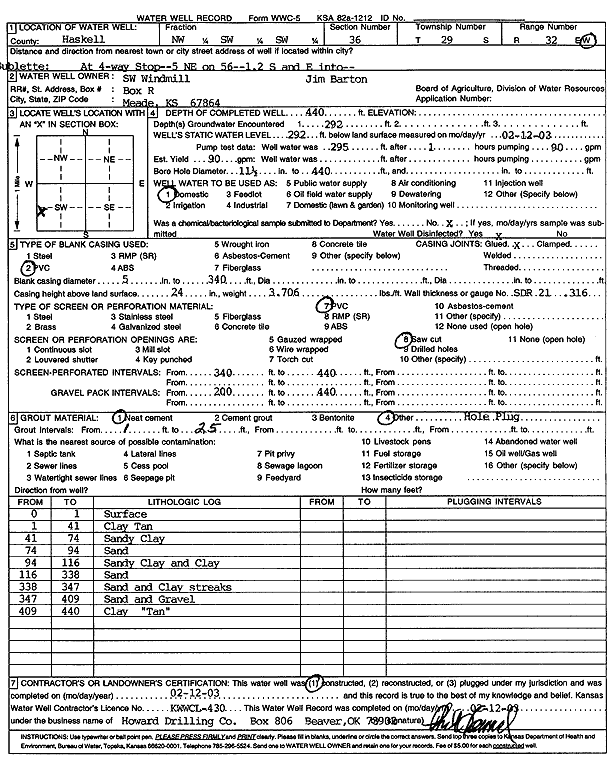
T29S, R32W, Sec. 36 NW SW SW |
Southwest Windmill | 440 ft. | 292 ft. | 90 gpm. | Domestic | Constructed | 12-Feb-2003 | Scan | |
|
T29S, R32W, Sec. 36 SE SE NE |
White Exploration Inc | 300 ft. | 300 ft. | 90 gpm. | Oil Field Water Supply | Phoenix Farms 1 | Constructed | 12-Jan-2009 | |
|
T29S, R33W, Sec. 1 SW NE SE NW |
Bartlett Cattle Co. | 617 ft. | 425 ft. | 1003 gpm. | Irrigation | Constructed | 06-Nov-2014 |
KOLAR |
|
|
T29S, R33W, Sec. 1 SE SE NE |
Haskell County Cemetary | 458 ft. | Domestic | Constructed | 23-Aug-1975 | ||||
|
T29S, R33W, Sec. 2 SE NW NW |
Beredco Inc | 540 ft. | 340 ft. | 100 gpm. | Oil Field Water Supply | Dennis 3-2 | Constructed | 10-Apr-1993 | |
|
T29S, R33W, Sec. 2 NE NE NE |
BP America Production Co. | 605 ft. | 370 ft. | 45 gpm. | Domestic | Constructed | 03-Nov-2004 | ||
|
T29S, R33W, Sec. 2 NE SE NE NE |
BP America Production Company | 250 ft. | Oil Field Water Supply | Plugged | 17-Aug-2007 | ||||
|
T29S, R33W, Sec. 2 SE NE NE |
BP America Production Company | 380 ft. | Oil Field Water Supply | Plugged | 17-Aug-2007 | ||||
|
T29S, R33W, Sec. 2 SW SW NW |
Brown Enterprises | 560 ft. | 380 ft. | Irrigation | Plugged | 20-Sep-2000 | |||
|
T29S, R33W, Sec. 2 C W2 SW |
Diaden Farms | 703 ft. | 367 ft. | Irrigation | Constructed | 27-Mar-1999 | Scan | ||
|
T29S, R33W, Sec. 2 SE SE NW |
Diaden Farms | 323 ft. | 300 ft. | Irrigation | Irrigation Well 1958 | Plugged | 22-Nov-1993 | ||
|
T29S, R33W, Sec. 2 NW SE NW |
Diaden Farms | 323 ft. | 300 ft. | Irrigation | Plugged | 22-Nov-1993 | |||
|
T29S, R33W, Sec. 2 SW SW NE |
Jordan Hefner AG Inc. | 764 ft. | 431 ft. | 600 gpm. | Irrigation | Constructed | 20-Apr-2022 |
KOLAR |
|
|
T29S, R33W, Sec. 2 SW SW NE |
Jordan Hefner AG Inc. | 460 ft. | 368 ft. | Irrigation | Plugged | 29-Mar-2023 |
KOLAR |
||
|
T29S, R33W, Sec. 2 NE NW |
Presco Western LLC | 550 ft. | 370 ft. | 100 gpm. | Oil Field Water Supply | Diaden Farms 1 B | Constructed | 21-May-2007 | |
|
T29S, R33W, Sec. 3 NE SE SE |
Longwood Farms | 415 ft. | 355 ft. | Irrigation | Plugged | 23-Nov-1993 | |||
|
T29S, R33W, Sec. 3 SW SE SE |
O. W. Longwood | 607 ft. | 308 ft. | 1800 gpm. | Irrigation | Constructed | 04-Apr-1978 | ||
|
T29S, R33W, Sec. 3 SE NW NE |
Oxy USA, Inc. | 560 ft. | 360 ft. | 110 gpm. | Oil Field Water Supply | Longwood A 2 | Constructed | 12-Feb-1993 | |
|
T29S, R33W, Sec. 3 NW NE SE |
Oxy USA, Inc. | 540 ft. | 360 ft. | 110 gpm. | Oil Field Water Supply | Longwood A 1 | Constructed | 15-Mar-1993 | |
|
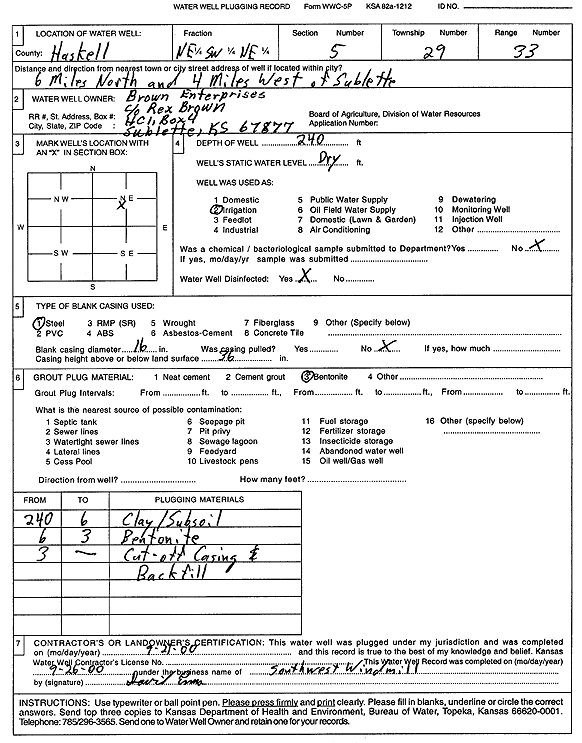
T29S, R33W, Sec. 5 NE SW NE |
Brown Enterprises | 240 ft. | Irrigation | Plugged | 21-Sep-2000 | Scan | |||
|
T29S, R33W, Sec. 5 NE SW NE |
Brown, Inc. | 595 ft. | 356 ft. | Irrigation | Constructed | 14-Jan-1999 | Scan | ||
|
T29S, R33W, Sec. 5 NE NE NE |
Desbien, Ed | 580 ft. | 312 ft. | 25 gpm. | Domestic | Constructed | 24-Aug-1979 | ||
|
T29S, R33W, Sec. 6 NW NW NW SE |
Clawson Land Partnership | 681 ft. | 422 ft. | 1690 gpm. | Irrigation | Constructed | 07-Apr-2018 |
KOLAR |
|
|
T29S, R33W, Sec. 6 NW NW SE |
Clawson, Mary R. | 668 ft. | 363 ft. | Irrigation | Constructed | 11-Oct-2002 | Scan | ||
|
T29S, R33W, Sec. 6 SW SW |
Zenith Drilling Corp. Inc. | 360 ft. | 270 ft. | 50 gpm. | Oil Field Water Supply | Wheatley 2-5 | Constructed | 16-Dec-1977 | |
|
T29S, R33W, Sec. 7 NW SW |
Clawson, Kenby | 643 ft. | 356 ft. | Irrigation | Constructed | 18-Jul-2007 | |||
|
T29S, R33W, Sec. 7 SW SE SW NE |
Kelman Farms | 780 ft. | 366 ft. | 1081 gpm. | Irrigation | Constructed | 19-Feb-2014 |
KOLAR |
|
|
T29S, R33W, Sec. 7 NW SE SE |
Ricker, Leonard | 510 ft. | 248 ft. | 1200 gpm. | Irrigation | Constructed | 30-Jun-1977 | ||
|
T29S, R33W, Sec. 8 SW SW SE |
Lowe, Archie | 685 ft. | 420 ft. | 800 gpm. | Irrigation | Constructed | 13-Mar-2023 |
KOLAR |
|
|
T29S, R33W, Sec. 8 SE NE SW |
Trimpa, Nick | 546 ft. | 248 ft. | 1373 gpm. | Irrigation | Constructed | 26-Dec-1975 | ||
|
T29S, R33W, Sec. 9 NW SW SW |
Lemon and Sons | 471 ft. | 337 ft. | Irrigation | Plugged | 27-Mar-1990 | |||
|
T29S, R33W, Sec. 11 SE SE NW |
Dixit, Myrtipse | 412 ft. | 342 ft. | Irrigation | Plugged | 22-Nov-1993 | |||
|
T29S, R33W, Sec. 11 SW NW NW |
Elliot, Merton | 629 ft. | 309 ft. | 1400 gpm. | Irrigation | Constructed | 25-Jun-1980 | ||
|
T29S, R33W, Sec. 12 SE NE NW NE |
4S Farms LLC | 741 ft. | 379 ft. | 230 gpm. | Irrigation | Constructed | 15-Apr-2015 |
KOLAR |
|
|
T29S, R33W, Sec. 12 SE NE NW NE |
4S Farms LLC | 741 ft. | 381 ft. | Irrigation | Plugged | 10-May-2017 | |||
|
T29S, R33W, Sec. 12 NE NE NE NE |
4S Farms LLC | 573 ft. | 384 ft. | Irrigation | Plugged | 09-May-2017 | |||
|
T29S, R33W, Sec. 12 SW NW NW NE |
4S Farms LLC | 768 ft. | 378 ft. | 535 gpm. | Irrigation | Constructed | 20-Jun-2016 |
KOLAR |
|
| View page: < Prev || 31 || 32 || 33 || 34 || 35 || 36 || 37 || 38 || 39 || 40 || Next > | |||||||||