Select location of well to view details.
Click on column heading to sort.
|
|
|
County: Haskell Select location of well to view details. Click on column heading to sort. |
|
|
|
| View page: < Prev || 41 || 42 || 43 || 44 || 45 || 46 | |||||||||
| T-R-S | Owner | Well Depth Ascend. Desc. |
Static Water Level Ascend. Desc. |
Est. Yield Ascend. Desc. |
Well Use | Other ID | Action Taken | Completion Date Ascend. Desc. |
Scan? |
|
T30S, R34W, Sec. 2 SW SW NE |
C. M. Light Estate/Murfin Drilling | 440 ft. | 285 ft. | Oil Field Water Supply | Plugged | 20-Apr-1998 | |||
|
T30S, R34W, Sec. 2 NE |
Foster, Don | 527 ft. | Irrigation | Constructed | 20-Nov-1979 | ||||
|
T30S, R34W, Sec. 2 NE NE SW |
KP Land Company LLC | 696 ft. | 384 ft. | 1256 gpm. | Irrigation | Constructed | 22-Dec-2024 |
KOLAR |
|
|
T30S, R34W, Sec. 2 NE NE NE |
Light Investments LLC | 664 ft. | 355 ft. | Irrigation | Constructed | 22-Jan-2003 | Scan | ||
|
T30S, R34W, Sec. 3 NW SE NE SW |
Clawson Land Partnership | 626 ft. | 358 ft. | 700 gpm. | Irrigation | Constructed | 13-Feb-2014 |
KOLAR |
|
|
T30S, R34W, Sec. 3 SE NE SW |
Clawson, Kirby/ Murfin Drilling Inc | 420 ft. | 330 ft. | Oil Field Water Supply | Constructed | 17-Dec-1996 | |||
|
T30S, R34W, Sec. 3 NW NW NW |
Clawson, Kirby/ Murfin Drilling Inc | 410 ft. | 295 ft. | Oil Field Water Supply | Constructed | 29-Jul-1996 | |||
|
T30S, R34W, Sec. 3 NW NW NW |
Mesa Petroleum | 360 ft. | 275 ft. | Monitoring well/observation/piezometer | Constructed | 13-Feb-1987 | |||
|
T30S, R34W, Sec. 3 NW NW SW |
Pioneer Natural Resources | 360 ft. | 333 ft. | Monitoring well/observation/piezometer | Well 87-16 | Plugged | 13-Nov-2009 | ||
|
T30S, R34W, Sec. 5 C NE SE |
Hugoton Energy | 420 ft. | 300 ft. | 80 gpm. | Oil Field Water Supply | MLP Rooney 1-5 | Constructed | 03-Aug-1995 | |
|
T30S, R34W, Sec. 5 SW NE SW |
Marguerite Rooney Trust | 640 ft. | 327 ft. | Irrigation | Constructed | 28-Dec-2001 | Scan | ||
|
T30S, R34W, Sec. 5 NW NW |
Rooney Ranch Inc. | 632 ft. | 360 ft. | Irrigation | Constructed | 16-Oct-2009 | |||
|
T30S, R34W, Sec. 5 C NE SE |
Rooney, Archie/Murfin Drilling Inc | 580 ft. | 274 ft. | Oil Field Water Supply | Constructed | 12-Jun-1995 | |||
|
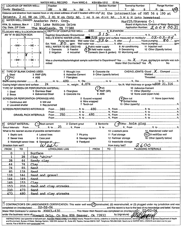
T30S, R34W, Sec. 7 NW NW SW |
Anadarko Petroleum Corp. | 480 ft. | 315 ft. | 80 gpm. | Oil Field Water Supply | Stevens C-1 | Constructed | 02-Feb-2004 | Scan |
|
T30S, R34W, Sec. 7 NE SE SW |
Stevens, Jim | 350 ft. | 247 ft. | Domestic | Constructed | 30-Dec-1976 | |||
|
T30S, R34W, Sec. 9 NE NW SW |
Rooney Ranch | 500 ft. | 210 ft. | 1400 gpm. | Irrigation | Constructed | 03-Mar-1977 | ||
|
T30S, R34W, Sec. 10 C NE |
Doris, Sig | 470 ft. | 338 ft. | 30 gpm. | Domestic | Constructed | 20-May-1991 | ||
|
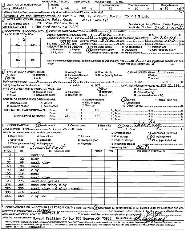
T30S, R34W, Sec. 11 E2 NE NW |
Anadarko Petroleum Corp. | 460 ft. | 262 ft. | 100 gpm. | Oil Field Water Supply | Weeks Farm A 2 | Constructed | 24-Jan-2004 | Scan |
|
T30S, R34W, Sec. 11 SW SE NW |
Hugoton Energy | 405 ft. | 230 ft. | 120 gpm. | Oil Field Water Supply | MLP Huxman 1-11 | Constructed | 15-Dec-1996 | |
|
T30S, R34W, Sec. 11 NW SW NW NW |
Leather Land Co. | 654 ft. | 366 ft. | 903 gpm. | Irrigation | Constructed | 19-Jun-2013 |
KOLAR |
|
|
T30S, R34W, Sec. 11 C NW NW |
Oxy USA, Inc. | 400 ft. | 305 ft. | 100 gpm. | Oil Field Water Supply | MLP Huxman A 1 | Constructed | 23-Jul-1993 | |
|
T30S, R34W, Sec. 11 NW NW NW |
Oxy USA, Inc. | 400 ft. | 305 ft. | Oil Field Water Supply | MLP Huxman A 1 | Plugged | 24-Feb-1994 | ||
|
T30S, R34W, Sec. 11 SE NW SW |
Weeks Farm LP | 637 ft. | 334 ft. | Irrigation | Constructed | 17-Jun-2008 | |||
|
T30S, R34W, Sec. 12 NE NE NE |
Satanta Municipal Airport | 508 ft. | 378 ft. | Domestic | Constructed | 25-Mar-2025 |
KOLAR |
||
|
T30S, R34W, Sec. 13 NW NE SE |
City of Satanta | 430 ft. | 261 ft. | 2000 gpm. | Public Water Supply | Constructed | 20-Sep-1983 | ||
|
T30S, R34W, Sec. 13 NE NE SW |
City of Satanta | Public Water Supply | Plugged | 04-Apr-1988 | |||||
|
T30S, R34W, Sec. 13 SE SE NW |
City of Satanta | 460 ft. | 326 ft. | Monitoring well/observation/piezometer | Plugged | 02-Jun-2008 | |||
|
T30S, R34W, Sec. 13 NE NE SW |
City of Satanta | Public Water Supply | Plugged | 04-Apr-1988 | |||||
|
T30S, R34W, Sec. 13 SW NW NE |
City of Satanta | 475 ft. | 328 ft. | Irrigation | Plugged | 02-Jun-2008 | |||
|
T30S, R34W, Sec. 13 SW NW NE |
City of Satanta | 480 ft. | 329 ft. | Monitoring well/observation/piezometer | Plugged | 02-Jun-2008 | |||
|
T30S, R34W, Sec. 13 SW SW NE |
City of Satanta | 390 ft. | 326 ft. | Public Water Supply | Plugged | 02-Jun-2008 | |||
|
T30S, R34W, Sec. 13 SW NW NE |
City of Satanta | 540 ft. | 329 ft. | Monitoring well/observation/piezometer | Constructed | 28-Jun-2005 | |||
|
T30S, R34W, Sec. 13 SW NW NE |
City of Satanta | 543 ft. | 328 ft. | Public Water Supply | Constructed | 16-Dec-2006 | |||
|
T30S, R34W, Sec. 13 NW |
City of Satanta | 460 ft. | 326 ft. | Monitoring well/observation/piezometer | Constructed | 13-Jan-2005 | |||
|
T30S, R34W, Sec. 13 NE |
City of Satanta | 460 ft. | 326 ft. | Monitoring well/observation/piezometer | Constructed | 08-Jan-2005 | |||
|
T30S, R34W, Sec. 13 SW SW NE |
City of Satanta | 460 ft. | 326 ft. | Monitoring well/observation/piezometer | Plugged | 02-Jun-2008 | |||
|
T30S, R34W, Sec. 13 SW NW NE |
McDonald 66 | 390 ft. | Monitoring well/observation/piezometer | MW 12 | Constructed | 20-Mar-2008 | |||
|
T30S, R34W, Sec. 13 SW NW NE |
McDonald 66 | 390 ft. | 355.23 ft. | Monitoring well/observation/piezometer | MW 12 | Plugged | 23-Aug-2016 | ||
|
T30S, R34W, Sec. 13 SW NW NE |
McDonald 66 | 487 ft. | 353.68 ft. | Monitoring well/observation/piezometer | MW 11 | Plugged | 23-Aug-2016 | ||
|
T30S, R34W, Sec. 13 SW NW NE |
McDonald 66 | 350 ft. | Monitoring well/observation/piezometer | MW 10 | Plugged | 23-Aug-2016 | |||
|
T30S, R34W, Sec. 13 SE SW NE |
McDonald 66 | 312 ft. | 276 ft. | Monitoring well/observation/piezometer | MW 2 | Constructed | 25-Feb-1997 | ||
|
T30S, R34W, Sec. 13 SE SW NE |
McDonald 66 | 314 ft. | 303.5 ft. | Monitoring well/observation/piezometer | MW 4 | Constructed | 25-Apr-1997 | ||
|
T30S, R34W, Sec. 13 SW NW NE |
McDonald 66 | 350 ft. | 330 ft. | Monitoring well/observation/piezometer | MW 10 | Constructed | 19-Mar-2008 | ||
|
T30S, R34W, Sec. 13 SW SW NE |
McDonald 66 | 320 ft. | 299.02 ft. | Monitoring well/observation/piezometer | MW 7 | Constructed | 14-May-1997 | ||
|
T30S, R34W, Sec. 13 SE SW NE |
McDonald 66 | 310.5 ft. | 304.1 ft. | Monitoring well/observation/piezometer | MW 3 | Constructed | 16-Apr-1997 | ||
|
T30S, R34W, Sec. 13 SE SW NE |
McDonald 66 | 310.5 ft. | Monitoring well/observation/piezometer | MW 3 | Plugged | 22-Dec-2005 | |||
|
T30S, R34W, Sec. 13 SW SW NE |
McDonald 66 | 320 ft. | Monitoring well/observation/piezometer | MW 7 | Plugged | 22-Dec-2005 | |||
|
T30S, R34W, Sec. 13 SE SW NE |
McDonald 66 | 314 ft. | 303.5 ft. | Monitoring well/observation/piezometer | MW 4 | Plugged | 13-Oct-1998 | Scan | |
|
T30S, R34W, Sec. 13 SW NW NE |
McDonald 66 | 487 ft. | 330 ft. | Monitoring well/observation/piezometer | MW 11 | Constructed | 19-Mar-2008 | ||
|
T30S, R34W, Sec. 13 SW SW NE |
Quick and Easy | 320 ft. | Monitoring well/observation/piezometer | MW 5 | Plugged | 22-Dec-2005 | |||
| View page: < Prev || 41 || 42 || 43 || 44 || 45 || 46 | |||||||||