Select location of well to view details.
Click on column heading to sort.
|
|
|
County: Jefferson Select location of well to view details. Click on column heading to sort. |
|
|
|
| View page: < Prev || 11 || 12 || 13 || 14 || 15 || 16 || 17 || 18 || 19 || 20 || Next > | |||||||||
| T-R-S | Owner | Well Depth Ascend. Desc. |
Static Water Level Ascend. Desc. |
Est. Yield Ascend. Desc. |
Well Use | Other ID | Action Taken | Completion Date Ascend. Desc. |
Scan? |
|
T10S, R20E, Sec. 8 SE NE NE SW |
Haag Real Estate LLC | 30.04 ft. | 4.37 ft. | Monitoring well/observation/piezometer | MW 9 | Constructed | 07-Jun-2016 | ||
|
T10S, R20E, Sec. 8 SE SE SE NW |
Haag Real Estate LLC | 35 ft. | 11.56 ft. | Monitoring well/observation/piezometer | MW 4 | Constructed | 19-Aug-2015 | ||
|
T10S, R20E, Sec. 8 NW NW NW SE |
Haag Real Estate LLC | 28.9 ft. | 5.52 ft. | Monitoring well/observation/piezometer | MW 1 | Constructed | 18-Aug-2015 | ||
|
T10S, R20E, Sec. 8 NW NW NW SE |
Haag Real Estate LLC | 14.78 ft. | 1.17 ft. | Monitoring well/observation/piezometer | MW 8 | Constructed | 20-Aug-2015 | ||
|
T10S, R20E, Sec. 8 NW NW NW SE |
Haag Real Estate LLC | 24.82 ft. | 1.3 ft. | Monitoring well/observation/piezometer | MW 2 | Constructed | 18-Aug-2015 | ||
|
T10S, R20E, Sec. 8 NW NW NW SE |
Haag Real Estate LLC | 20 ft. | 3.25 ft. | Monitoring well/observation/piezometer | MW 7 | Constructed | 20-Aug-2015 | ||
|
T10S, R20E, Sec. 8 NE NE NE SW |
Haag Real Estate LLC | 31.9 ft. | 3.1 ft. | Monitoring well/observation/piezometer | MW 6 | Constructed | 18-Aug-2015 | ||
|
T10S, R20E, Sec. 8 NW NW NW SE |
Haag Real Estate LLC | 30.09 ft. | 3.09 ft. | Monitoring well/observation/piezometer | MW 12 | Constructed | 21-Apr-2016 | ||
|
T10S, R20E, Sec. 8 SW NW NW SE |
Haag Real Estate LLC | 20.56 ft. | 2.13 ft. | Monitoring well/observation/piezometer | MW 11 | Constructed | 07-Jun-2016 | ||
|
T10S, R20E, Sec. 8 NW NW NW SE |
Haag Real Estate LLC | 30.02 ft. | 5.36 ft. | Monitoring well/observation/piezometer | MW 14 | Constructed | 21-Apr-2016 | ||
|
T10S, R20E, Sec. 8 NW NW NW SE |
Haag Real Estate LLC | 29.66 ft. | 6.97 ft. | Monitoring well/observation/piezometer | MW 13 | Constructed | 08-Jun-2016 | ||
|
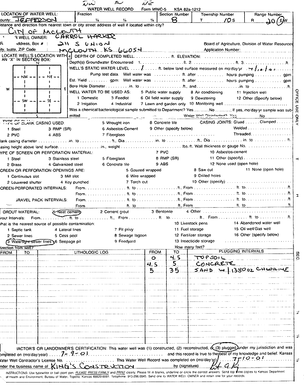
T10S, R20E, Sec. 8 NW SW NE |
Harker, Carrol | 1 ft. | (unstated)/abandoned | Plugged | 09-Jul-2001 | Scan | |||
|
T10S, R20E, Sec. 8 SW NW NW SE |
KDHE | 20.02 ft. | 2.01 ft. | Monitoring well/observation/piezometer | MW 10 | Constructed | 07-Jun-2016 | ||
|
T10S, R20E, Sec. 8 SE SE NW |
McLouth United Methodist Church | 33 ft. | 11 ft. | Domestic | Plugged | 27-Nov-1999 | Scan | ||
|
T10S, R20E, Sec. 8 NW SE NE |
Walters, Perry and Laura | 281 ft. | 14 ft. | Domestic | Plugged | 15-Apr-1998 | |||
|
T10S, R20E, Sec. 9 SW SW NW |
Kimmel, James R. | 70 ft. | 60 ft. | Feedlot | Plugged | 24-Aug-2000 | Scan | ||
|
T10S, R20E, Sec. 16 NW NE SW |
Northern, Fred | 100 ft. | 35 ft. | 1090 gpm. | Domestic | Constructed | |||
|
T10S, R20E, Sec. 21 NE |
Rollins | 125 ft. | 4.5 gpm. | Domestic | Constructed | ||||
|
T10S, R20E, Sec. 21 SW NE SW |
Theroff | 100 ft. | 38 ft. | 15 gpm. | Domestic | Constructed | 20-Feb-1966 | ||
|
T10S, R20E, Sec. 28 SE NE NW |
PODOLANKE, JOHN | 80 ft. | 11 ft. | 2 gpm. | Domestic | Constructed | 05-May-1986 | ||
|
T10S, R20E, Sec. 32 NE SW |
Doane, Eugene Skip | 60 ft. | 6 gpm. | Domestic | Constructed | 08-May-1975 | |||
|
T11S, R16E, Sec. 1 SW SW SW SE |
Lauffer, Carol | 200 ft. | 0 gpm. | Geothermal, Closed Loop, Vertical | Constructed | 28-Jul-2016 | |||
|
T11S, R16E, Sec. 13 NE SE SW |
Henderson, Cliff | 83 ft. | 28 ft. | 200 gpm. | Irrigation | Constructed | 12-Sep-1990 | ||
|
T11S, R16E, Sec. 13 SW SW SE |
Jefferson Co. RWD 1 | 79 ft. | 8 gpm. | Test hole/well | TW 2-92 | Constructed | 04-Feb-1992 | ||
|
T11S, R16E, Sec. 13 SW SW SE |
Jefferson Co. RWD 1 | 60 ft. | 29 ft. | Public Water Supply | Well 4 | Constructed | 15-Oct-1992 | ||
|
T11S, R16E, Sec. 13 SW SW SE |
Jefferson Co. RWD 1 | 79 ft. | 8 gpm. | Test hole/well | TW 2-92 | Plugged | 04-Feb-1992 | ||
|
T11S, R16E, Sec. 13 SW SE SE |
Jefferson Co. RWD 1 | 79 ft. | 30 ft. | Test hole/well | TW 1-92 | Plugged | 22-Apr-1992 | ||
|
T11S, R16E, Sec. 13 SE SW SE |
Jefferson Co. RWD 1 | 84 ft. | 30 ft. | Public Water Supply | Well 3 | Constructed | 13-Oct-1992 | ||
|
T11S, R16E, Sec. 13 SW SE SE |
Jefferson Co. RWD 1 | 79 ft. | 30 ft. | Test hole/well | TW 1-92 | Constructed | 27-Jan-1992 | ||
|
T11S, R16E, Sec. 13 SE |
Jefferson Co. RWD 1 | 80 ft. | 51 ft. | Public Water Supply | Plugged | 28-Sep-2017 | |||
|
T11S, R16E, Sec. 13 SW SW SE SE |
Jefferson Co. RWD 1 | 83.5 ft. | 29 ft. | Public Water Supply | 5 | Constructed | 14-Nov-2017 | ||
|
T11S, R16E, Sec. 13 SE SW SW |
Rees, Norris | 82 ft. | 30 ft. | 500 gpm. | Irrigation | Constructed | 26-Aug-1983 | ||
|
T11S, R16E, Sec. 24 NW NE NW SW |
Bigham, Caroline | 52 ft. | 10 ft. | 30 gpm. | Domestic | Constructed | 26-Jul-2018 |
KOLAR |
|
|
T11S, R16E, Sec. 24 SW SW NE |
Grindol, Tom | 40 ft. | 22 ft. | 40 gpm. | Domestic | Constructed | 12-Nov-1987 | ||
|
T11S, R16E, Sec. 24 NE NE SE |
J.C. Meier and Son | 45 ft. | 26 ft. | 40 gpm. | Domestic | Constructed | 26-May-1989 | ||
|
T11S, R16E, Sec. 24 SW NE SW |
Lawrence, Jerry R. | 41 ft. | 23 ft. | 65 gpm. | Domestic | Constructed | 26-Oct-2006 | ||
|
T11S, R16E, Sec. 24 SE SE SE |
Meier, Todd and Debra | 57 ft. | Domestic | Constructed | 11-Jan-2005 | ||||
|
T11S, R16E, Sec. 24 C SE |
Riverside Farms | 46 ft. | 21 ft. | 600 gpm. | Irrigation | Constructed | 11-Mar-2005 | ||
|
T11S, R16E, Sec. 24 NE NW SE SE |
Riverside Farms | 46 ft. | 26 ft. | Irrigation | Constructed | 12-Feb-2013 | |||
|
T11S, R16E, Sec. 24 NE SW NW |
Tucker, Merril | 40 ft. | 25 ft. | 20 gpm. | Irrigation | Constructed | 26-Apr-1977 | ||
|
T11S, R16E, Sec. 25 NE SW NE |
Hook Bros. | 53 ft. | 11 ft. | 750 gpm. | Irrigation | Constructed | 10-Oct-1993 | ||
|
T11S, R16E, Sec. 25 NE SE NW |
Hook Farms | 57 ft. | 21 ft. | 1000 gpm. | Irrigation | Constructed | 16-Jan-1992 | ||
|
T11S, R16E, Sec. 25 C SW |
Hook, Maynard | 51 ft. | 23 ft. | 1000 gpm. | Irrigation | Constructed | 03-Apr-1977 | ||
|
T11S, R16E, Sec. 25 NE SW NE |
Hook, Robert M. | 53 ft. | 32 ft. | Irrigation | Reconstructed | 31-May-1998 | |||
|
T11S, R16E, Sec. 25 NE NE NW NW |
Ingenthron Family Farm, LLC | 58 ft. | 23 ft. | Irrigation | Constructed | 07-Mar-2014 | |||
|
T11S, R16E, Sec. 25 SE SW NW |
Ingenthron, Tom | 45 ft. | 27 ft. | 30 gpm. | Domestic | Constructed | 25-Apr-1989 | ||
|
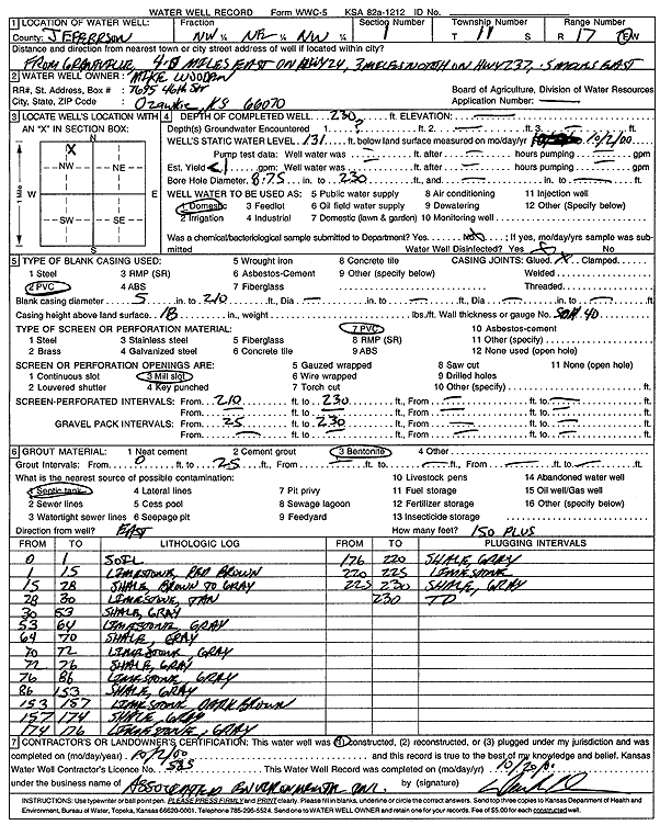
T11S, R17E, Sec. 1 NW NE NW |
Wooden, Mike | 230 ft. | 131 ft. | 1 gpm. | Domestic | Constructed | 02-Oct-2000 | Scan | |
|
T11S, R17E, Sec. 2 NE NE NE |
Clark, Bob | 288 ft. | 172 ft. | 70 gpm. | Domestic | Constructed | 04-Mar-1996 | ||
|
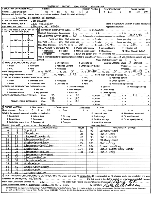
T11S, R17E, Sec. 2 NE NE NE |
DeLapp, Jim | 160 ft. | 62 ft. | 6 gpm. | Domestic | Constructed | 15-Sep-1999 | Scan | |
|
T11S, R17E, Sec. 2 SE SE SE |
Wade, William D. | 50 ft. | 15 ft. | 4 gpm. | Domestic, Lawn and Garden | Constructed | 03-Jul-1985 | ||
| View page: < Prev || 11 || 12 || 13 || 14 || 15 || 16 || 17 || 18 || 19 || 20 || Next > | |||||||||