Select location of well to view details.
Click on column heading to sort.
|
|
|
County: Coffey Select location of well to view details. Click on column heading to sort. |
|
|
|
| View page: 1 || 2 || 3 || 4 || 5 || 6 || 7 || 8 || 9 || 10 || Next > | |||||||||
| T-R-S | Owner | Well Depth Ascend. Desc. |
Static Water Level Ascend. Desc. |
Est. Yield Ascend. Desc. |
Well Use | Other ID | Action Taken | Completion Date Ascend. Desc. |
Scan? |
|
T19S, R14E, Sec. 4 NE SE NE SE |
Casey's Retail Co. | 19.5 ft. | 6.3 ft. | Monitoring well/observation/piezometer | MW 7 | Constructed | 09-Feb-2023 | ||
|
T19S, R14E, Sec. 4 NE SE NE SE |
Casey's Retail Co. | 15.5 ft. | 4.85 ft. | Monitoring well/observation/piezometer | MW 8 | Constructed | 10-Feb-2023 | ||
|
T19S, R14E, Sec. 4 NE SE NE SE |
Casey's Retail Co. | 19 ft. | 11.75 ft. | Monitoring well/observation/piezometer | MW 6 | Constructed | 09-Feb-2023 | ||
|
T19S, R14E, Sec. 4 NE SE NE SE |
Casey's Retail Co. | 15 ft. | 4.35 ft. | Monitoring well/observation/piezometer | MW 5 | Constructed | 10-Feb-2023 | ||
|
T19S, R14E, Sec. 4 SE SE NE SE |
Casey's Retail Co. | 15.5 ft. | 4.27 ft. | Monitoring well/observation/piezometer | MW 4 | Constructed | 23-Jan-2023 | ||
|
T19S, R14E, Sec. 4 SE SE NE SE |
Casey's Retail Co. | 15.5 ft. | 3.95 ft. | Monitoring well/observation/piezometer | MW 3 | Constructed | 09-Feb-2023 | ||
|
T19S, R14E, Sec. 4 SE SE NE SE |
Casey's Retail Co. | 15.5 ft. | 5 ft. | Monitoring well/observation/piezometer | MW 2 | Constructed | 08-Feb-2023 | ||
|
T19S, R14E, Sec. 4 NE SE NE SE |
Casey's Retail Co. | 24.5 ft. | .1 ft. | Monitoring well/observation/piezometer | MW 1 | Constructed | 23-Jan-2023 | ||
|
T19S, R14E, Sec. 4 SE NE SE |
Casey's Retail Co. | 20 ft. | 7.6 ft. | Monitoring well/observation/piezometer | MW 9 | Plugged | 26-Jun-2025 |
KOLAR |
|
|
T19S, R14E, Sec. 4 SE NE SE |
Casey's Retail Co. | 14.7 ft. | 2.9 ft. | Monitoring well/observation/piezometer | MW 2 | Plugged | 26-Jun-2025 |
KOLAR |
|
|
T19S, R14E, Sec. 4 SE NE SE |
Casey's Retail Co. | 14.2 ft. | 4.2 ft. | Monitoring well/observation/piezometer | MW 5 | Plugged | 26-Jun-2025 |
KOLAR |
|
|
T19S, R14E, Sec. 4 SE NE SE |
Casey's Retail Co. | 18.3 ft. | 5.3 ft. | Monitoring well/observation/piezometer | MW 6 | Plugged | 26-Jun-2025 |
KOLAR |
|
|
T19S, R14E, Sec. 4 SE NE SE |
Casey's Retail Co. | 15 ft. | 4.7 ft. | Monitoring well/observation/piezometer | MW 8 | Plugged | 26-Jun-2025 |
KOLAR |
|
|
T19S, R14E, Sec. 4 NE SE NE SE |
Casey's Retail Co. | 20.5 ft. | 9.57 ft. | Monitoring well/observation/piezometer | MW 9 | Constructed | 08-Feb-2023 | ||
|
T19S, R14E, Sec. 4 SE NE SE |
Casey's Retail Co. | 14.8 ft. | 2.9 ft. | Monitoring well/observation/piezometer | MW 4 | Plugged | 26-Jun-2025 |
KOLAR |
|
|
T19S, R14E, Sec. 4 SE NE SE |
Casey's Retail Co. | 14.8 ft. | 4.2 ft. | Monitoring well/observation/piezometer | MW 3 | Plugged | 26-Jun-2025 |
KOLAR |
|
|
T19S, R14E, Sec. 4 SE NE SE |
Casey's Retail Co. | 23.8 ft. | 2.5 ft. | Monitoring well/observation/piezometer | MW 1 | Plugged | 26-Jun-2025 |
KOLAR |
|
|
T19S, R14E, Sec. 4 SE NE SE |
Casey's Retail Co. | 18.6 ft. | 4.7 ft. | Monitoring well/observation/piezometer | MW 7 | Plugged | 26-Jun-2025 |
KOLAR |
|
|
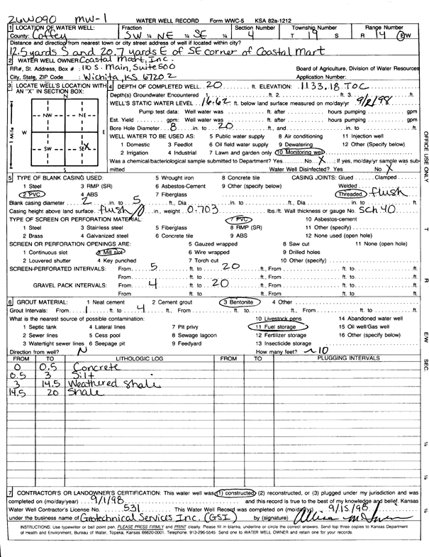
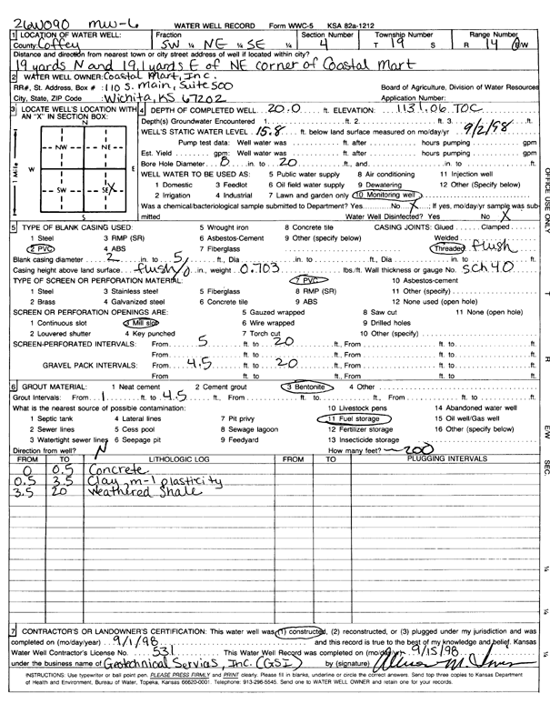
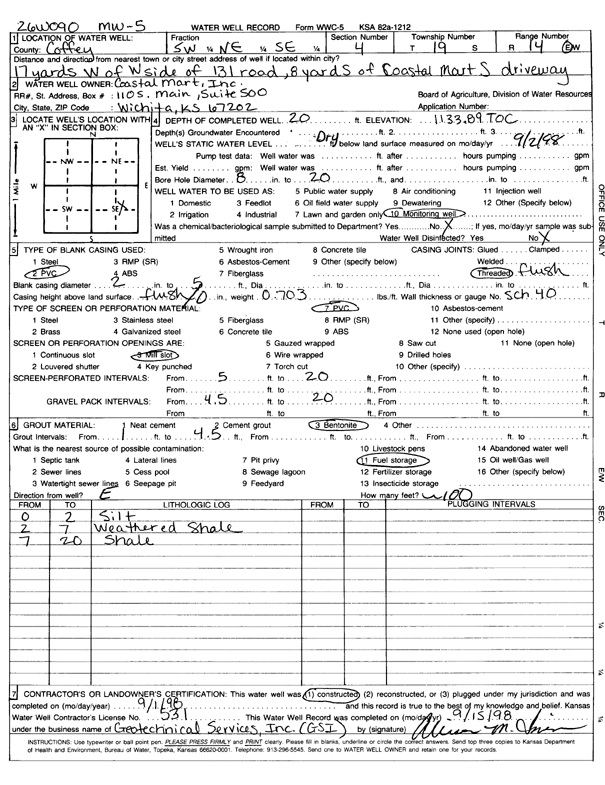
T19S, R14E, Sec. 4 SW NE SE |
Coastal Mart | 20 ft. | 16.62 ft. | Monitoring well/observation/piezometer | MW 1 | Constructed | 01-Sep-1998 | Scan | |
|
T19S, R14E, Sec. 4 SW NE SE |
Coastal Mart | 18.45 ft. | 4.45 ft. | Monitoring well/observation/piezometer | MW 4 | Plugged | 23-Sep-2005 | ||
|
T19S, R14E, Sec. 4 SW NE SE |
Coastal Mart | 19.63 ft. | 4.48 ft. | Monitoring well/observation/piezometer | MW 5 | Plugged | 23-Sep-2005 | ||
|
T19S, R14E, Sec. 4 SW NE SE |
Coastal Mart | 14.17 ft. | 6.23 ft. | Monitoring well/observation/piezometer | MW 3 | Plugged | 23-Sep-2005 | ||
|
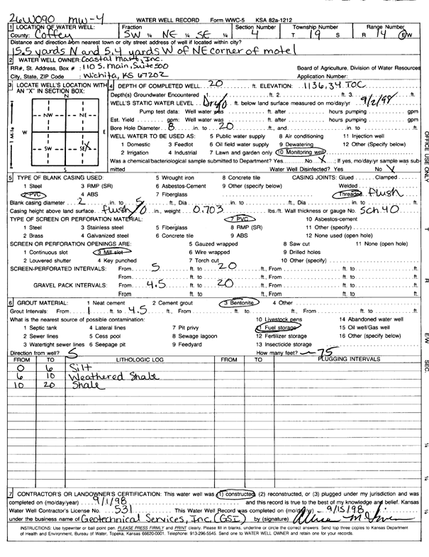
T19S, R14E, Sec. 4 SW NE SE |
Coastal Mart | 20 ft. | Monitoring well/observation/piezometer | MW 4 | Constructed | 01-Sep-1998 | Scan | ||
|
T19S, R14E, Sec. 4 NE NE SE |
Coastal Mart | 18.34 ft. | 7.68 ft. | Monitoring well/observation/piezometer | MW 2 | Plugged | 23-Sep-2005 | ||
|
T19S, R14E, Sec. 4 SW NE SE |
Coastal Mart | 19.74 ft. | 6.25 ft. | Monitoring well/observation/piezometer | MW 6 | Plugged | 23-Sep-2005 | ||
|
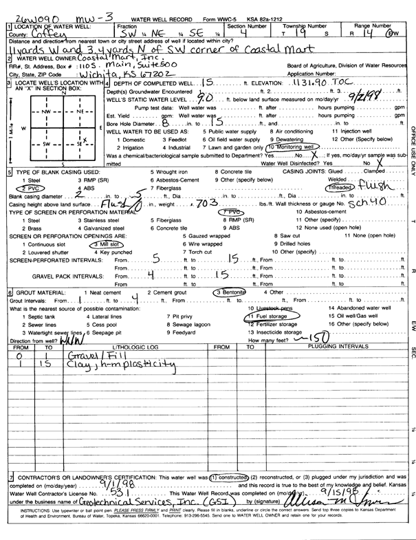
T19S, R14E, Sec. 4 SW NE SE |
Coastal Mart | 15 ft. | 9 ft. | Monitoring well/observation/piezometer | MW 3 | Constructed | 01-Sep-1998 | Scan | |
|
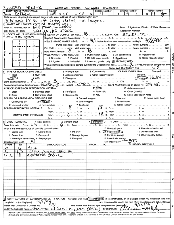
T19S, R14E, Sec. 4 NE NE SE |
Coastal Mart | 18 ft. | 13.1 ft. | Monitoring well/observation/piezometer | MW 2 | Constructed | 01-Sep-1998 | Scan | |
|
T19S, R14E, Sec. 4 SW NE SE |
Coastal Mart | 20.12 ft. | 3.48 ft. | Monitoring well/observation/piezometer | MW 1 | Plugged | 23-Sep-2005 | ||
|
T19S, R14E, Sec. 4 SW NE SE |
Coastal Mart | 20 ft. | 15.8 ft. | Monitoring well/observation/piezometer | MW 6 | Constructed | 01-Sep-1998 | Scan | |
|
T19S, R14E, Sec. 4 SW NE SE |
Coastal Mart | 20 ft. | Monitoring well/observation/piezometer | MW 5 | Constructed | 01-Sep-1998 | Scan | ||
|
T19S, R14E, Sec. 6 SW SE SE |
Traylor, David | 30 ft. | 10 ft. | Domestic | Plugged | 07-Sep-1996 | |||
|
T19S, R14E, Sec. 6 SW SE SE |
Traylor, David | 25.5 ft. | 8 ft. | Domestic | Plugged | 07-Sep-1996 | |||
|
T19S, R14E, Sec. 8 NE SE NE |
Krause, Keith | 200 ft. | Geothermal, Closed Loop, Vertical | Constructed | 01-Jun-2011 | ||||
|
T19S, R14E, Sec. 9 SE SE NE |
City of Lebo | 68 ft. | Public Water Supply | well 1 | Constructed | 01-Mar-1954 | |||
|
T19S, R14E, Sec. 9 SE SE NE |
City of Lebo | 75 ft. | Public Water Supply | well 2 | Constructed | 01-Mar-1954 | |||
|
T19S, R14E, Sec. 9 NE NW NE |
Criqui, Rodney | 30 ft. | 25 ft. | Domestic | Plugged | 26-Nov-1997 | |||
|
T19S, R14E, Sec. 9 SE NE SE NE |
D and S Service | 19 ft. | 1.15 ft. | Monitoring well/observation/piezometer | DMW 13 | Constructed | 30-Apr-2013 | ||
|
T19S, R14E, Sec. 9 SE NE SE NE |
D and S Service | 15 ft. | 3.25 ft. | Monitoring well/observation/piezometer | DMW 15 | Constructed | 29-Apr-2013 | ||
|
T19S, R14E, Sec. 9 NE NE SE NE |
D and S Service | 11 ft. | Environmental Remediation, Air Sparge | ASOW 1 | Constructed | 01-May-2013 | |||
|
T19S, R14E, Sec. 9 SE NE SE NE |
D and S Service | 7 ft. | Environmental Remediation, Soil Vapor Extraction | VOBW 4 | Constructed | 02-May-2013 | |||
|
T19S, R14E, Sec. 9 SE NE SE NE |
D and S Service | 20 ft. | 2.26 ft. | Monitoring well/observation/piezometer | DMW 14 | Constructed | 30-Apr-2013 | ||
|
T19S, R14E, Sec. 9 SE NE SE NE |
D and S Service | 20 ft. | 1.15 ft. | Monitoring well/observation/piezometer | DMW 12 | Constructed | 01-May-2013 | ||
|
T19S, R14E, Sec. 9 NE NE SE NE |
D and S Service | 7 ft. | Environmental Remediation, Soil Vapor Extraction | VOBW 3 | Constructed | 02-May-2013 | |||
|
T19S, R14E, Sec. 9 NE NE SE NE |
D and S Service | 7 ft. | Environmental Remediation, Soil Vapor Extraction | VOBW 2 | Constructed | 02-May-2013 | |||
|
T19S, R14E, Sec. 9 NE NE SE NE |
D and S Service | 13 ft. | Environmental Remediation, Soil Vapor Extraction | VOBW 1 | Constructed | 01-May-2013 | |||
|
T19S, R14E, Sec. 9 NE NE SE NE |
D and S Service | 7 ft. | Environmental Remediation, Soil Vapor Extraction | SVE 1 | Constructed | 01-May-2013 | |||
|
T19S, R14E, Sec. 9 NE NE SE NE |
D and S Service | 20 ft. | 3.92 ft. | Monitoring well/observation/piezometer | DMW 16 | Constructed | 03-May-2013 | ||
|
T19S, R14E, Sec. 9 NE NE SE NE |
D and S Service | 11 ft. | Environmental Remediation, Air Sparge | AS 1 | Constructed | 01-May-2013 | |||
|
T19S, R14E, Sec. 9 SE NE SE NE |
D and S Service Station, LLC | 15 ft. | 5.14 ft. | Monitoring well/observation/piezometer | DMW 9 | Constructed | 11-Dec-2012 | ||
|
T19S, R14E, Sec. 9 NE NE SE NE |
D and S Service Station, LLC | 20 ft. | 6.84 ft. | Monitoring well/observation/piezometer | DMW 7 | Constructed | 12-Dec-2012 | ||
| View page: 1 || 2 || 3 || 4 || 5 || 6 || 7 || 8 || 9 || 10 || Next > | |||||||||