Select location of well to view details.
Click on column heading to sort.
|
|
|
County: Linn Select location of well to view details. Click on column heading to sort. |
|
|
|
| View page: 1 || 2 || 3 || 4 || 5 || 6 || 7 || 8 || 9 || 10 || Next > | |||||||||
| T-R-S | Owner | Well Depth Ascend. Desc. |
Static Water Level Ascend. Desc. |
Est. Yield Ascend. Desc. |
Well Use | Other ID | Action Taken | Completion Date Ascend. Desc. |
Scan? |
|
T20S, R22E, Sec. 3 NW |
Magellan Pipeline Company L.P. | 7.4 ft. | Monitoring well/observation/piezometer | MW 10 | Constructed | 06-Apr-2005 | |||
|
T20S, R22E, Sec. 4 NE NW NW |
Williamson, Ken | 100 ft. | .25 gpm. | Domestic | Plugged | 23-Sep-1996 | |||
|
T20S, R22E, Sec. 15 E2 NW |
Dunlop, Raymond | 40 ft. | Domestic | Plugged | 30-Mar-1993 | ||||
|
T20S, R22E, Sec. 24 NE NW NW |
Isenhower, B.J. | 15 ft. | 5 ft. | Domestic | Plugged | Scan | |||
|
T20S, R22E, Sec. 29 NW NW |
Magellan Midstream Partners, LP | 15 ft. | Monitoring well/observation/piezometer | MW 2 | Constructed | 05-Apr-2013 | |||
|
T20S, R22E, Sec. 29 NW NW |
Magellan Midstream Partners, LP | 15 ft. | Monitoring well/observation/piezometer | MW 2 | Plugged | 30-Nov-2016 | |||
|
T20S, R22E, Sec. 29 NW NW |
Magellan Midstream Partners, LP | 14 ft. | Monitoring well/observation/piezometer | MW 3 | Constructed | 05-Apr-2013 | |||
|
T20S, R22E, Sec. 29 NW NW |
Magellan Midstream Partners, LP | 14 ft. | Monitoring well/observation/piezometer | MW 3 | Plugged | 30-Nov-2016 | |||
|
T20S, R22E, Sec. 29 NW NW |
Magellan Midstream Partners, LP | 12 ft. | Monitoring well/observation/piezometer | MW 1 | Constructed | 05-Apr-2013 | |||
|
T20S, R22E, Sec. 29 NW NW |
Magellan Midstream Partners, LP | 12 ft. | Monitoring well/observation/piezometer | MW 1 | Plugged | 30-Nov-2016 | |||
|
T20S, R22E, Sec. 29 NE NE NE |
Miller, Freda | 15 ft. | 14 ft. | (unstated)/abandoned | Plugged | 17-May-1999 | |||
|
T20S, R22E, Sec. 29 NE NE NE |
Miller, Freda | 12 ft. | 11 ft. | Other | Plugged | 17-May-1999 | |||
|
T20S, R22E, Sec. 34 NE NE NE |
Ringey, C.W. | 18 ft. | 9 ft. | Domestic | Plugged | 01-Sep-2007 | |||
|
T20S, R22E, Sec. 36 SE SE SE |
Garrelts, Greg and Linda Wilkerson | 210 ft. | 70 ft. | 2 gpm. | Domestic | Constructed | 09-May-2010 | ||
|
T20S, R23E, Sec. 8 W2 SW |
Shelton, Robert | 150 ft. | Geothermal, Closed Loop, Vertical | Constructed | 11-Jun-1996 | ||||
|
T20S, R23E, Sec. 19 SE SW SW |
Markley, Karen | 300 ft. | 70 ft. | 3 gpm. | Geothermal, Closed Loop, Vertical | Constructed | 07-Oct-2025 |
KOLAR |
|
|
T20S, R23E, Sec. 22 SE NE NE |
Carothers, Clayton | 13 ft. | 12 ft. | Domestic | Plugged | 01-Jun-1995 | |||
|
T20S, R23E, Sec. 23 SW SW NW |
Carothers, Clayton | 6 ft. | 5.25 ft. | Domestic | Plugged | 01-Jun-1995 | |||
|
T20S, R23E, Sec. 26 NW SW NE |
Deveo, Jack | 350 ft. | 130 ft. | 5 gpm. | Domestic | Constructed | 03-Dec-2009 | ||
|
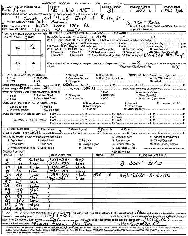
T20S, R23E, Sec. 31 SE NW NE |
Salmon, Mike | 350 ft. | Geothermal, Closed Loop, Vertical | Constructed | 17-Nov-2003 | Scan | |||
|
T20S, R23E, Sec. 34 NW NW SE |
Fountain, Mary Sue | 150 ft. | Test Hole, Uncased | Plugged | 29-May-2006 | ||||
|
T20S, R23E, Sec. 34 SE SW SW |
Sawyer, John | 120 ft. | Test Hole, Uncased | Plugged | 13-Aug-1996 | ||||
|
T20S, R23E, Sec. 35 NW SE SW |
EuDaly, Lon | 180 ft. | Heat Pump (Closed Loop/Disposal), Geothermal | Constructed | 18-Oct-2004 | ||||
|
T20S, R23E, Sec. 35 NW SE SW |
EuDaly, Lon | 360 ft. | Heat Pump (Closed Loop/Disposal), Geothermal | Constructed | 24-Sep-2004 | ||||
|
T20S, R24E, Sec. 3 SW NW |
Linn County | 34 ft. | 12 ft. | Domestic | Plugged | 06-Jul-1998 | |||
|
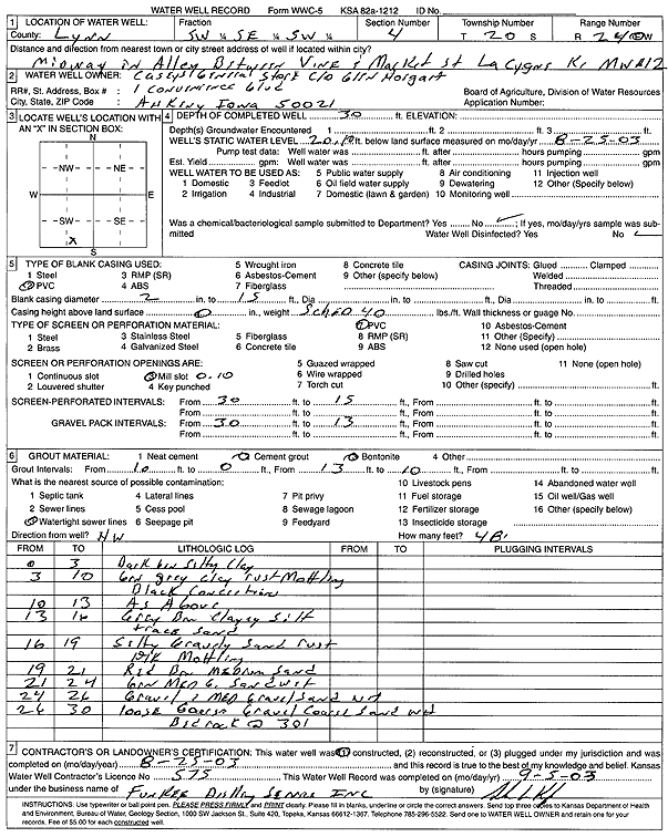
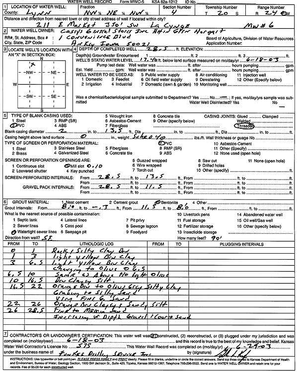
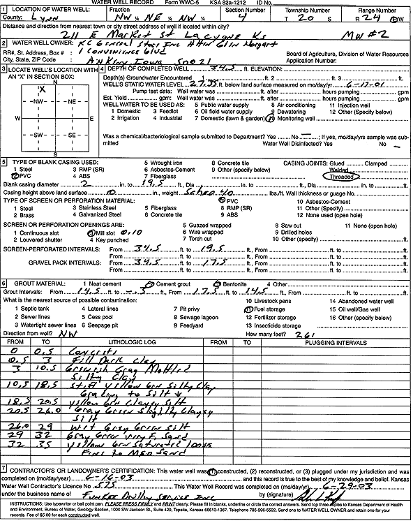
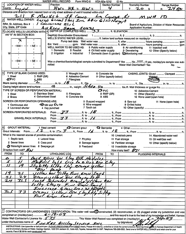
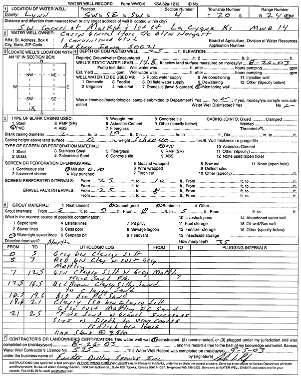
T20S, R24E, Sec. 4 SW SE SW |
Casey's General Store | 30 ft. | 20.1 ft. | Monitoring well/observation/piezometer | MW 12 | Constructed | 25-Aug-2003 | Scan | |
|
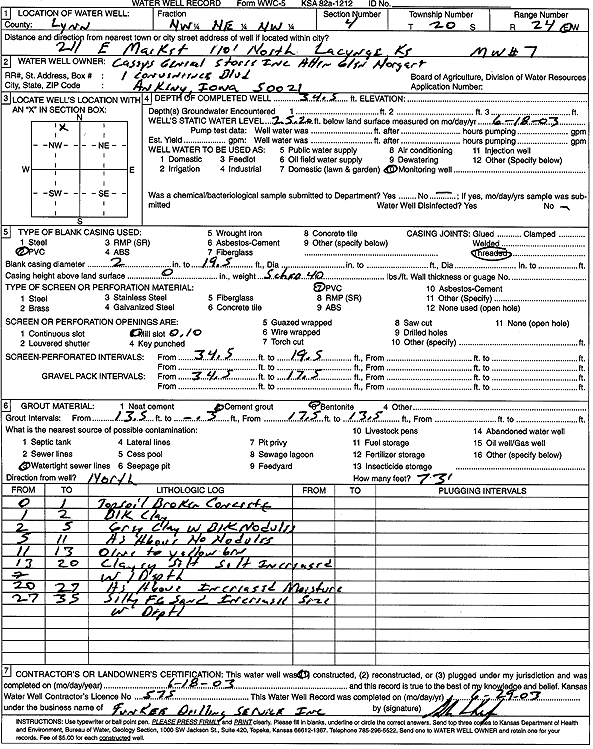
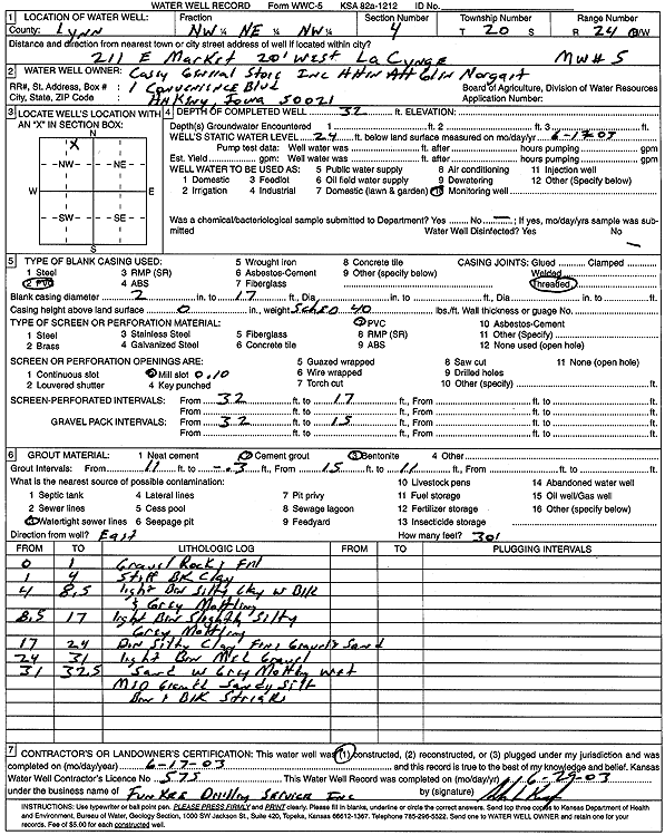
T20S, R24E, Sec. 4 NW NE NW |
Casey's General Store | 34.5 ft. | 30.5 ft. | Monitoring well/observation/piezometer | MW 8 | Constructed | 18-Jun-2003 | Scan | |
|
T20S, R24E, Sec. 4 NW NE NW |
Casey's General Store | 34.5 ft. | 25.2 ft. | Monitoring well/observation/piezometer | MW 7 | Constructed | 18-Jun-2003 | Scan | |
|
T20S, R24E, Sec. 4 NW NE NW |
Casey's General Store | 28.5 ft. | 17.4 ft. | Monitoring well/observation/piezometer | MW 6 | Constructed | 18-Jun-2003 | Scan | |
|
T20S, R24E, Sec. 4 NW NE NW |
Casey's General Store | 32 ft. | 24 ft. | Monitoring well/observation/piezometer | MW 5 | Constructed | 17-Jun-2003 | Scan | |
|
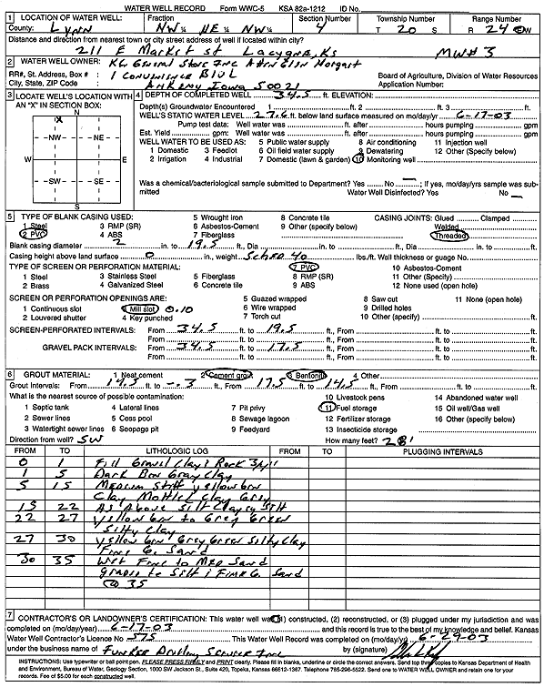
T20S, R24E, Sec. 4 NW NE NW |
Casey's General Store | 32.5 ft. | 21.7 ft. | Monitoring well/observation/piezometer | MW 4 | Constructed | 17-Jun-2003 | Scan | |
|
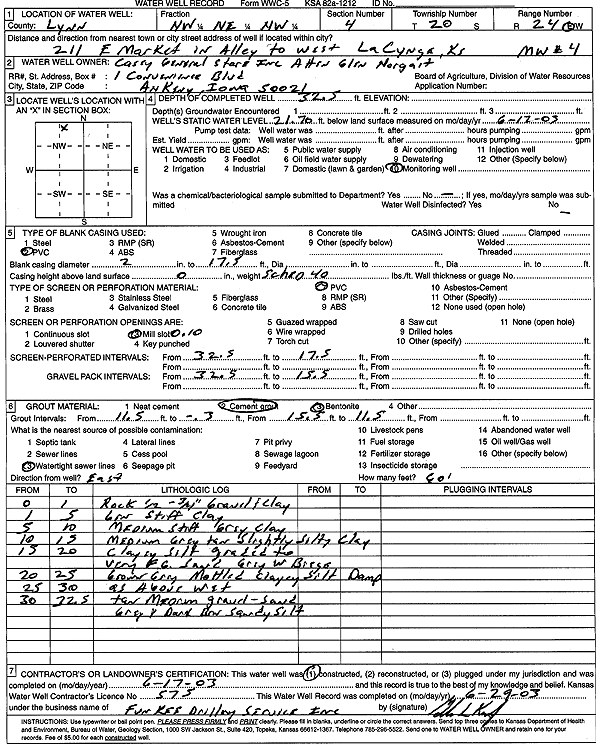
T20S, R24E, Sec. 4 NW NE NW |
Casey's General Store | 34.5 ft. | 27.6 ft. | Monitoring well/observation/piezometer | MW 3 | Constructed | 17-Jun-2003 | Scan | |
|
T20S, R24E, Sec. 4 NW NE NW |
Casey's General Store | 34.5 ft. | 27.35 ft. | Monitoring well/observation/piezometer | MW 2 | Constructed | 16-Jun-2003 | Scan | |
|
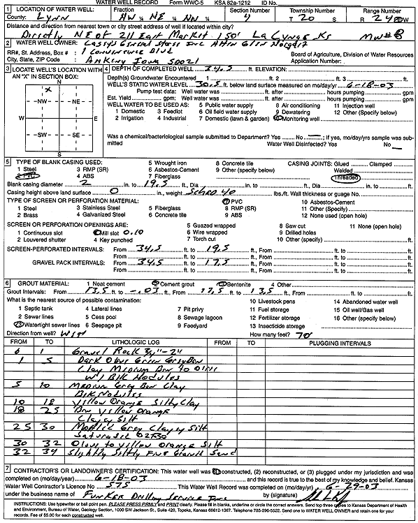
T20S, R24E, Sec. 4 NW NE NW |
Casey's General Store | 33 ft. | Monitoring well/observation/piezometer | MW 10 | Constructed | 19-Jun-2003 | Scan | ||
|
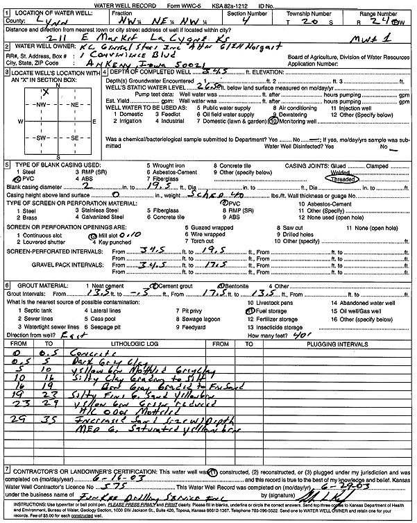
T20S, R24E, Sec. 4 NW NE NW |
Casey's General Store | 34.5 ft. | 26.5 ft. | Monitoring well/observation/piezometer | MW 1 | Constructed | 16-Jun-2003 | Scan | |
|
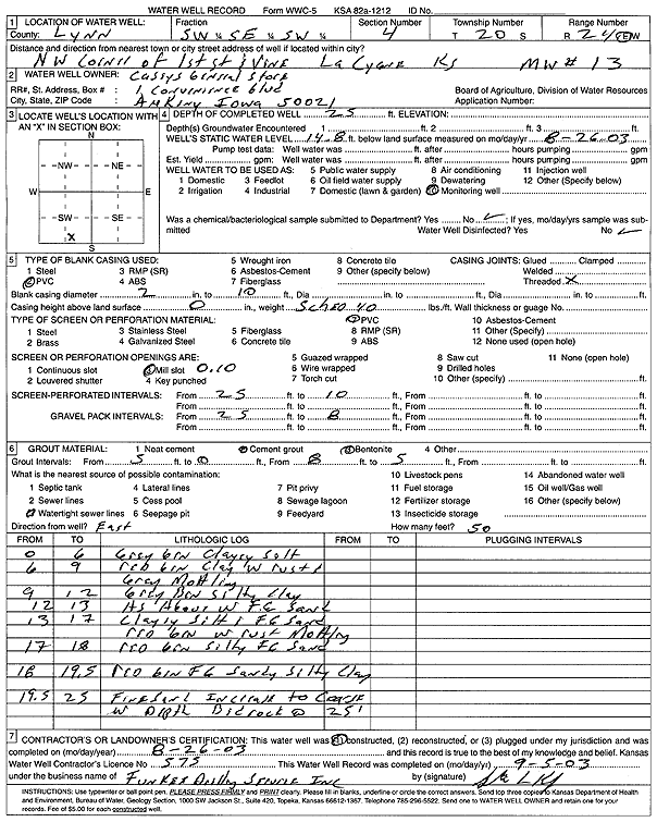
T20S, R24E, Sec. 4 SW SE SW |
Casey's General Store | 25 ft. | 14.8 ft. | Monitoring well/observation/piezometer | MW 13 | Constructed | 26-Aug-2003 | Scan | |
|
T20S, R24E, Sec. 4 SW SE SW |
Casey's General Store | 25 ft. | 14.8 ft. | Monitoring well/observation/piezometer | MW 14 | Constructed | 26-Aug-2003 | Scan | |
|
T20S, R24E, Sec. 4 SE SW NE |
Reed Minerals Division | 80 ft. | 29 ft. | Industrial | Constructed | 26-Apr-1985 | |||
|
T20S, R24E, Sec. 5 NW NE SE |
McClintic, Edith | 29 ft. | 13 ft. | 6 gpm. | Domestic | Constructed | 16-Nov-2007 | ||
|
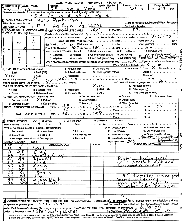
T20S, R24E, Sec. 11 SE SE NW |
Pemberton, Herb | 100 ft. | 20 ft. | 10 gpm. | Industrial | Reconstructed | 14-Jun-2000 | Scan | |
|
T20S, R24E, Sec. 11 SE SE SW |
Pemberton, Herb | 100 ft. | 20 ft. | 10 gpm. | Domestic, Lawn and Garden | Constructed | 21-Aug-1980 | ||
|
T20S, R24E, Sec. 12 SE SE SE |
Stinner, James A. and Kim G. | 10 ft. | 9 ft. | Domestic | Plugged | 11-Jun-1997 | |||
|
T20S, R24E, Sec. 13 SW SW NW NE |
Keller, Charles | 100 ft. | 40 ft. | 4 gpm. | Domestic | Constructed | 22-Apr-2020 | ||
|
T20S, R24E, Sec. 13 NE NE NW SE |
Kern, Jon | 200 ft. | Geothermal, Closed Loop, Vertical | Constructed | 30-Aug-2013 | ||||
|
T20S, R24E, Sec. 14 SE SE NW |
Jackson, David | 24 ft. | 19 ft. | Domestic | Plugged | 22-Jun-2002 | Scan | ||
|
T20S, R24E, Sec. 14 NW NE |
Wolfenberger, Robert | 80 ft. | 20 ft. | 15 gpm. | Domestic | Constructed | 08-Sep-1992 | ||
|
T20S, R24E, Sec. 15 SE NE NW SW |
Manning, Tom | 80 ft. | 20 ft. | .5 gpm. | Domestic | Constructed | 22-Aug-2018 |
KOLAR |
|
|
T20S, R24E, Sec. 15 NE SW SW |
W.D. Oil Co. | 102 ft. | 40 ft. | 2 gpm. | Oil Field Water Supply | Constructed | 30-Jun-1981 | ||
|
T20S, R24E, Sec. 16 NW |
Fry Family Enterprises | 18 ft. | 11 ft. | Other | Plugged | 01-Mar-2006 | |||
|
T20S, R24E, Sec. 16 NW |
Fry Family Enterprises | 10 ft. | 8 ft. | Other | Plugged | 01-Mar-2006 | |||
| View page: 1 || 2 || 3 || 4 || 5 || 6 || 7 || 8 || 9 || 10 || Next > | |||||||||